
Pike of Blisco
Encyclopedia
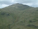
Pike of Blisco, or Pike o' Blisco, is a mountain
in the Lake District
in Cumbria
, England
. Located between the valleys of Great Langdale
and Little Langdale
, its relative isolation from neighbouring fell
s together with slopes falling away immediately from the summit in all directions mean it has excellent views: the view of the Langdale Pikes across Great Langdale is particularly arresting.
The name Pike of Blisco is the form used on Ordnance Survey
maps. The influential guidebook writer A. Wainwright preferred Pike o' Blisco (he refers to Pike of Blisco as its "Sunday name"), and wrote, "the man has no blood in his veins who does not respond eagerly to its fine-sounding, swashbuckling
name".
. The ridge incorporates Esk Pike
, Bow Fell, Crinkle Crags
and Cold Pike
before turning sharply north-eastward to Pike of Blisco; it then makes a further abrupt northerly diversion around Blea Tarn to connect to Lingmoor Fell
. To the north of Pike of Blisco is the Oxendale branch of Great Langdale
, while Little Langdale
stands to the south east. The two valleys drain eastward, joining beyond Lingmoor Fell. To the south of Pike of Blisco is the 393 m (1,290 ft) summit of Wrynose Pass
, which links Little Langdale with the Duddon Valley
, and beyond the pass lies Swirl How
and the Coniston Fells.
Between Cold Pike and Pike of Blisco is a wide grassy depression at 528 m (1,740 ft). On the southern side is the source of the River Duddon
, while to the north is Red Tarn, a feeder of Great Langdale Beck. Red Tarn is an elongated pool whose stony bed can be seen through clear shallow waters, reputed to hold trout. Its name comes from the colour of the surrounding soil rather than the water itself. The tarn
forms a focal point for walkers, as the wide path from the summit of Wrynose Pass to Great Langdale runs beside it, with a further path branching off across its outflow towards Crinkle Crags. The main path was originally made to serve Red Crag Mine
, which now consists of a series of pits and trial borings for iron ore, concentrated about 300 metres north of the tarn. The mine was worked from 1860 to 1875 but never achieved commercial success.
Pike of Blisco itself consists of the steep, conical summit area above Red Tarn along with a swathe of hilly country speading out to the south and east. The summit is defended by Kettle Crag to the north and Black Wars to the west, with Black Crag abreast the ridge descending southward to Wrynose Pass. The eastern part of the fell is centred upon the subsidiary top of Blake Rigg at around 530 m (1,740 ft) in an area of rocky outcrops and small tarns. From Blake Rigg a ridge runs north east to cross the summit of the Blea Tarn road at 224 m (735 ft). This pass, narrow and steep even by Lakeland standards, links the two Langdales and is named for the large tarn which sits beneath the eastern crags of Blake Rigg. Its waters hold trout, perch and pike, and the easily accessible shoreline features in many a photograph of the Langdale Pikes.
, tuff
and lapilli
-tuff
of the Blisco Member predominate, with an intrusion of rhyolite
running across the eastern slopes.
. (Consequently, a good view of the valley may be obtained from the summit.) Before 1959 the summit was crowned with a tall, conical cairn
which could be seen from the valley, but between 1958 and 1959 it was apparently vandalised
. It has subsequently been rebuilt, although it does not appear as tall today as it does in Wainwright's 1958 drawing.
; from here it follows the public footpath over the Oxendale Beck and up to Red Tarn, at around 525 m above sea level, before ascending Pike of Blisco's steep west face. The other route, which takes a generally more even gradient, climbs the mountain's east face using a path that starts from the Little Langdale road.
It is also possible to climb Pike of Blisco from Little Langdale, via a public footpath from Wrynose Bridge on the road to Wrynose Pass
, about 2 km (1.2 mi) from the head of the valley. An alternative route from this direction, recommended by Wainwright, involves scrambling
up a gully in the crags
above the valley head, then walking across pathless terrain to the summit. The easiest route of ascent, however, is from the Three Shire Stone
at the head of the Wrynose Pass, where vehicles may be parked at 393 metres.
Pike of Blisco is often climbed as a circuit around the head of Great Langdale incorporating Crinkle Crags
and Bowfell
, sometimes extended to include Rossett Pike
and even the Langdale Pikes.
Mountain
Image:Himalaya_annotated.jpg|thumb|right|The Himalayan mountain range with Mount Everestrect 58 14 160 49 Chomo Lonzorect 200 28 335 52 Makalurect 378 24 566 45 Mount Everestrect 188 581 920 656 Tibetan Plateaurect 250 406 340 427 Rong River...
in the Lake District
Lake District
The Lake District, also commonly known as The Lakes or Lakeland, is a mountainous region in North West England. A popular holiday destination, it is famous not only for its lakes and its mountains but also for its associations with the early 19th century poetry and writings of William Wordsworth...
in Cumbria
Cumbria
Cumbria , is a non-metropolitan county in North West England. The county and Cumbria County Council, its local authority, came into existence in 1974 after the passage of the Local Government Act 1972. Cumbria's largest settlement and county town is Carlisle. It consists of six districts, and in...
, England
England
England is a country that is part of the United Kingdom. It shares land borders with Scotland to the north and Wales to the west; the Irish Sea is to the north west, the Celtic Sea to the south west, with the North Sea to the east and the English Channel to the south separating it from continental...
. Located between the valleys of Great Langdale
Great Langdale
Great Langdale is a valley in the Lake District National Park in the county of Cumbria, in the northwest of England. It is often simply referred to as Langdale, the epithet Great distinguishing it from the neighbouring valley of Little Langdale....
and Little Langdale
Little Langdale
Little Langdale is a valley in the Lake District, England containing Little Langdale Tarn and a hamlet also called Little Langdale. A second tarn, Blea Tarn, is in a hanging valley between Little Langdale and the larger Great Langdale to the north...
, its relative isolation from neighbouring fell
Fell
“Fell” is a word used to refer to mountains, or certain types of mountainous landscape, in Scandinavia, the Isle of Man, and parts of northern England.- Etymology :...
s together with slopes falling away immediately from the summit in all directions mean it has excellent views: the view of the Langdale Pikes across Great Langdale is particularly arresting.
The name Pike of Blisco is the form used on Ordnance Survey
Ordnance Survey
Ordnance Survey , an executive agency and non-ministerial government department of the Government of the United Kingdom, is the national mapping agency for Great Britain, producing maps of Great Britain , and one of the world's largest producers of maps.The name reflects its creation together with...
maps. The influential guidebook writer A. Wainwright preferred Pike o' Blisco (he refers to Pike of Blisco as its "Sunday name"), and wrote, "the man has no blood in his veins who does not respond eagerly to its fine-sounding, swashbuckling
Swashbuckler
Swashbuckler or swasher is a term that emerged in the 16th century and has been used for rough, noisy and boastful swordsmen ever since. A possible explanation for this term is that it derives from a fighting style using a side-sword with a buckler in the off-hand, which was applied with much...
name".
Topography
Pike of Blisco stands on the complex ridge of high ground descending south-eastward from the Scafell massifScafell Pike
Scafell Pike is the highest mountain in England at . It is located in Lake District National Park sometimes confused with the neighbouring Sca Fell, to which it is connected by the col of Mickledore...
. The ridge incorporates Esk Pike
Esk Pike
Esk Pike is a fell in the English Lake District, one of the great cirque of hills forming the head of Eskdale.-Topography:The Southern Fells include the highest ground in England, a horseshoe which begins with Scafell and Scafell Pike in the west and then curves around the north of Upper Eskdale to...
, Bow Fell, Crinkle Crags
Crinkle Crags
Crinkle Crags is a fell in the English Lake District in the county of Cumbria. It forms part of two major rings of mountains, surrounding the valleys of Great Langdale and Upper Eskdale. The name reflects the fell's physical appearance as its summit ridge is a series of five rises and depressions ...
and Cold Pike
Cold Pike
Cold Pike is a fell in the English Lake District. It is a satellite of Crinkle Crags and stands above the Upper Duddon Valley.-Topography:...
before turning sharply north-eastward to Pike of Blisco; it then makes a further abrupt northerly diversion around Blea Tarn to connect to Lingmoor Fell
Lingmoor Fell
Lingmoor Fell is a fell in the English Lake District, situated eight kilometres west of Ambleside. The fell reaches a modest height of 469 m and divides the valleys of Great Langdale and Little Langdale. The fell's name originates from the Old Norse word lyng meaning “heather covered”...
. To the north of Pike of Blisco is the Oxendale branch of Great Langdale
Great Langdale
Great Langdale is a valley in the Lake District National Park in the county of Cumbria, in the northwest of England. It is often simply referred to as Langdale, the epithet Great distinguishing it from the neighbouring valley of Little Langdale....
, while Little Langdale
Little Langdale
Little Langdale is a valley in the Lake District, England containing Little Langdale Tarn and a hamlet also called Little Langdale. A second tarn, Blea Tarn, is in a hanging valley between Little Langdale and the larger Great Langdale to the north...
stands to the south east. The two valleys drain eastward, joining beyond Lingmoor Fell. To the south of Pike of Blisco is the 393 m (1,290 ft) summit of Wrynose Pass
Wrynose Pass
The Wrynose Pass is a mountain pass in the Lake District National Park in Cumbria, England between the Duddon Valley and Little Langdale.-Road:...
, which links Little Langdale with the Duddon Valley
Duddon Valley
The Duddon Valley is a valley in the Lake District National Park in Cumbria, England. The River Duddon flows through the valley, rising in the mountains between Eskdale and Langdale, before flowing into the Irish Sea near Broughton in Furness...
, and beyond the pass lies Swirl How
Swirl How
Swirl How is a fell in the English Lake District. It stands between Coniston and the Duddon Valley in the southern part of the District.The Coniston Fells form the watershed between Coniston Water and the Duddon valley to the west. The range begins at Wrynose Pass and runs south for around...
and the Coniston Fells.
Between Cold Pike and Pike of Blisco is a wide grassy depression at 528 m (1,740 ft). On the southern side is the source of the River Duddon
River Duddon
The Duddon is a river of north-west England. It rises at a point above sea level near the Three Shire Stone at the highest point of Wrynose Pass . The river descends to the sea over a course of about before entering the Irish Sea at the Duddon Sands. For its entire length the Duddon forms the...
, while to the north is Red Tarn, a feeder of Great Langdale Beck. Red Tarn is an elongated pool whose stony bed can be seen through clear shallow waters, reputed to hold trout. Its name comes from the colour of the surrounding soil rather than the water itself. The tarn
Tarn (lake)
A tarn is a mountain lake or pool, formed in a cirque excavated by a glacier. A moraine may form a natural dam below a tarn. A corrie may be called a cirque.The word is derived from the Old Norse word tjörn meaning pond...
forms a focal point for walkers, as the wide path from the summit of Wrynose Pass to Great Langdale runs beside it, with a further path branching off across its outflow towards Crinkle Crags. The main path was originally made to serve Red Crag Mine
Mining
Mining is the extraction of valuable minerals or other geological materials from the earth, from an ore body, vein or seam. The term also includes the removal of soil. Materials recovered by mining include base metals, precious metals, iron, uranium, coal, diamonds, limestone, oil shale, rock...
, which now consists of a series of pits and trial borings for iron ore, concentrated about 300 metres north of the tarn. The mine was worked from 1860 to 1875 but never achieved commercial success.
Pike of Blisco itself consists of the steep, conical summit area above Red Tarn along with a swathe of hilly country speading out to the south and east. The summit is defended by Kettle Crag to the north and Black Wars to the west, with Black Crag abreast the ridge descending southward to Wrynose Pass. The eastern part of the fell is centred upon the subsidiary top of Blake Rigg at around 530 m (1,740 ft) in an area of rocky outcrops and small tarns. From Blake Rigg a ridge runs north east to cross the summit of the Blea Tarn road at 224 m (735 ft). This pass, narrow and steep even by Lakeland standards, links the two Langdales and is named for the large tarn which sits beneath the eastern crags of Blake Rigg. Its waters hold trout, perch and pike, and the easily accessible shoreline features in many a photograph of the Langdale Pikes.
Geology
The interbedded volcaniclastic sandstoneSandstone
Sandstone is a sedimentary rock composed mainly of sand-sized minerals or rock grains.Most sandstone is composed of quartz and/or feldspar because these are the most common minerals in the Earth's crust. Like sand, sandstone may be any colour, but the most common colours are tan, brown, yellow,...
, tuff
Tuff
Tuff is a type of rock consisting of consolidated volcanic ash ejected from vents during a volcanic eruption. Tuff is sometimes called tufa, particularly when used as construction material, although tufa also refers to a quite different rock. Rock that contains greater than 50% tuff is considered...
and lapilli
Lapilli
Lapilli is a size classification term for tephra, which is material that falls out of the air during a volcanic eruption or during some meteorite impacts. Lapilli means "little stones" in Latin. They are in some senses similar to ooids or pisoids in calcareous sediments.By definition lapilli range...
-tuff
Tuff
Tuff is a type of rock consisting of consolidated volcanic ash ejected from vents during a volcanic eruption. Tuff is sometimes called tufa, particularly when used as construction material, although tufa also refers to a quite different rock. Rock that contains greater than 50% tuff is considered...
of the Blisco Member predominate, with an intrusion of rhyolite
Rhyolite
This page is about a volcanic rock. For the ghost town see Rhyolite, Nevada, and for the satellite system, see Rhyolite/Aquacade.Rhyolite is an igneous, volcanic rock, of felsic composition . It may have any texture from glassy to aphanitic to porphyritic...
running across the eastern slopes.
Summit and view
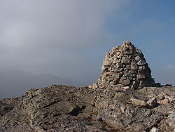
Unusually for Lake District fells, Pike of Blisco's summit is clearly visible from the valley below, in this case Great LangdaleGreat Langdale
Great Langdale is a valley in the Lake District National Park in the county of Cumbria, in the northwest of England. It is often simply referred to as Langdale, the epithet Great distinguishing it from the neighbouring valley of Little Langdale....
. (Consequently, a good view of the valley may be obtained from the summit.) Before 1959 the summit was crowned with a tall, conical cairn
Cairn
Cairn is a term used mainly in the English-speaking world for a man-made pile of stones. It comes from the or . Cairns are found all over the world in uplands, on moorland, on mountaintops, near waterways and on sea cliffs, and also in barren desert and tundra areas...
which could be seen from the valley, but between 1958 and 1959 it was apparently vandalised
Vandalism
Vandalism is the behaviour attributed originally to the Vandals, by the Romans, in respect of culture: ruthless destruction or spoiling of anything beautiful or venerable...
. It has subsequently been rebuilt, although it does not appear as tall today as it does in Wainwright's 1958 drawing.
Ascent routes
There are two distinct routes to the summit from the popular walkers' resort of Dungeon Ghyll at the head of Great Langdale. One goes via Stool End farm at the foot of BowfellBowfell
Bowfell is a pyramid-shaped mountain lying at the heart of the English Lake District, in the Southern Fells area. It is the sixth highest mountain in the lakes and one of the most popular of the Lake District fells...
; from here it follows the public footpath over the Oxendale Beck and up to Red Tarn, at around 525 m above sea level, before ascending Pike of Blisco's steep west face. The other route, which takes a generally more even gradient, climbs the mountain's east face using a path that starts from the Little Langdale road.
It is also possible to climb Pike of Blisco from Little Langdale, via a public footpath from Wrynose Bridge on the road to Wrynose Pass
Wrynose Pass
The Wrynose Pass is a mountain pass in the Lake District National Park in Cumbria, England between the Duddon Valley and Little Langdale.-Road:...
, about 2 km (1.2 mi) from the head of the valley. An alternative route from this direction, recommended by Wainwright, involves scrambling
Scrambling
Scrambling is a method of ascending rocky faces and ridges. It is an ambiguous term that lies somewhere between hillwalking and rock climbing. It is often distinguished from hillwalking by defining a scramble as a route where hands must be used in the ascent...
up a gully in the crags
Cliff
In geography and geology, a cliff is a significant vertical, or near vertical, rock exposure. Cliffs are formed as erosion landforms due to the processes of erosion and weathering that produce them. Cliffs are common on coasts, in mountainous areas, escarpments and along rivers. Cliffs are usually...
above the valley head, then walking across pathless terrain to the summit. The easiest route of ascent, however, is from the Three Shire Stone
Three Shire Stone (Lake District)
The Three Shire Stone is a boundary stone that marks the location where the historic English counties of Lancashire, Cumberland and Westmorland meet...
at the head of the Wrynose Pass, where vehicles may be parked at 393 metres.
Pike of Blisco is often climbed as a circuit around the head of Great Langdale incorporating Crinkle Crags
Crinkle Crags
Crinkle Crags is a fell in the English Lake District in the county of Cumbria. It forms part of two major rings of mountains, surrounding the valleys of Great Langdale and Upper Eskdale. The name reflects the fell's physical appearance as its summit ridge is a series of five rises and depressions ...
and Bowfell
Bowfell
Bowfell is a pyramid-shaped mountain lying at the heart of the English Lake District, in the Southern Fells area. It is the sixth highest mountain in the lakes and one of the most popular of the Lake District fells...
, sometimes extended to include Rossett Pike
Rossett Pike
Rossett Pike is a fell in the English Lake District. It is located at the head of Mickleden, one of two tributary valleys of Great Langdale.-Topography:...
and even the Langdale Pikes.