
Pico de Orizaba
Encyclopedia
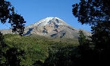
The Pico de Orizaba, or Citlaltépetl (from Nahuatl citlal(in) = star, and tepētl = mountain), is a stratovolcano
, the highest mountain
in Mexico
and the third highest
in North America
. It rises 5636 metres (18,490.8 ft) above sea level in the eastern end of the Trans-Mexican Volcanic Belt
, on the border between the states of Veracruz
and Puebla
. The volcano is currently dormant but not extinct with the last eruption taking place during the 19th century. It is the second most prominent
volcanic peak
in the world after Africa's Mount Kilimanjaro
.
, from which it gets its name. The name Citlaltépetl is not used by Nahuatl speakers of the Orizaba area, who instead call it Istaktepetl (Iztactépetl in the traditional orthography for Classical Nahuatl
) 'White Mountain'. The earliest mention of the volcano was referred to by the natives during the Pre-Columbian
Era as Poyautécatl which means, "The ground that reaches the clouds".
Citlaltépetl was the common name in the Náhuatl language when the Spanish arrived in Mexico. Citlaltépetl comes from the Náhuatl citialli (star) and tepētl (mountain) meaning "star mountain". Star mountain is thought to refer to the snow covered peak that can be seen year round for hundreds of kilometers around the region. A legend arises from the city of Coscomatepec which tells the story of how the planet Venus
can be seen settling into the crater of Citlaltépetl. During the colonial era, the volcano was also known as Cerro de San Andrés due to the close settlement of San Andrés Chalchicomula located at the base.
of 4922 m (16,148.3 ft). Regionally dominant, Pico de Orizaba is the highest peak in Mexico and the highest volcano in North America; it is also the third highest peak in North America after Mount McKinley
and Mount Logan
. Orizaba is ranked 7th in the world in topographic prominence
. It is the second most prominent volcanic peak
in the world after Africa's Mount Kilimanjaro
. About 110 km (68.4 mi) to the west of the port of Veracruz, its peak is visible to ships approaching the port in the Gulf of Mexico
, and at dawn rays of sunlight strike the Pico while Veracruz still lies in shadow. The volcano is also ranked 16th in the world for topographic isolation
.
The topography of Pico de Orizaba is asymmetrical
from the center of the crater; the eastern face is the steepest side of the volcano and the northwestern face the most gradual side. The gradual slopes of the northwestern face of the volcano allows for the presence of large glaciers and is the most traveled route to take for hikers traveling to the summit.
(ELA) is not known for Orizaba. Snow on the south and southeast sides of the volcano melts quickly because of solar radiation, but colder temperatures on the northwest and north sides allow for glaciers. The insolation angle and wind redeposition on the northwest and north sides allow for constant accumulation of snow providing a source for the outlet glaciers. On the north side of Orizaba, the Gran Glaciar Norte fills the elongated highland basin and is the source for seven outlet glaciers. The main glacier extends 3.5 kilometres (2.2 mi) north of the crater rim, has a surface area of about 9.08 square kilometres (3.5 sq mi) descending from 5650 metres (18,536.7 ft) to about 5000 metres (16,404.2 ft). It has a slightly irregular and stepped profile that is caused in part by the configuration of the bedrock. Most crevasses show an ice thickness of approximately 50 metres (164 ft).
Below the 5000 m (16,404.2 ft) in elevation on the north side of the volcano, the outlet glaciers Lengua del Chichimeco and Jamapa extend north and northwest another 1.5 km (0.93205910497471 mi) and 2 km (1.2 mi), respectively. The terminal lobe of Lengua del Chichimeco at 4740 metres (15,551.2 ft), having a gradient of only 140 m km−1 (26.5 ft/mi), is a low, broad ice fan that has a convex-upward profile, a front typical of almost all Mexican glaciers. The most distinct glacier is Glaciar de Jamapa, which leaves Gran Glaciar Norte at about 4975 m (16,322.2 ft) and, after 2 kilometres (1.2 mi) with a gradient of 145 m km− 1 (27.5 ft/mi), divides into two small tongues that end at 4650 m (15,255.9 ft) and 4640 m (15,223.1 ft). Both tongues terminate in broad convex-upward ice fans thinning along their edges.The retreat of these tongues prior to 1994 produced much erosion downstream and buried their edges by ablation rock debris.
The west side of Gran Glaciar Norte generates five outlet glaciers. From north to south, the first two, Glaciar del Toro and Glaciar dela Barba, are hanging cliff or icefall glaciers, reaching the tops of giant lava steps at 4930 m (16,174.5 ft) and 5090 m (16,699.5 ft), respectively. They then descend 200 to 300 m (656.2 to 984.3 ft) farther down into the heads of stream valleys as huge ice blocks but are not regenerated there. About 1 km (0.621372736649807 mi), Glaciar Noroccidental, a small outlet glacier 300 m (984.3 ft) long, drains away from the side of Gran Glaciar Norte at about 5100 m (16,732.3 ft) and draws down the ice surface a few tens of meters over a distance of 500 m (1,640.4 ft), descending to 4920 m (16,141.7 ft) with a gradient of 255 m km− 1 (48.3 ft/mi). Another 1 km (0.621372736649807 mi) still farther south, Glaciar Occidental breaks away from Gran Glaciar Norte west of the summit crater at about 5175 m (16,978.3 ft) as a steep, 1 km (0.621372736649807 mi) long glacier having a gradient of 270 m km− 1 (51.1 ft/mi) that ends at 4930 m (16,174.5 ft). From the southwest corner of the mountain, another outlet glacier, Glaciar Suroccidental, 1.6 km (0.994196378639691 mi) long, flows from Gran Glaciar Norte at 5250 m (17,224.4 ft) with a gradient of 200 m km− 1 (37.8 ft/mi), which also ends at 4930 m (16,174.5 ft) in a long smooth surface.
East of the summit cone, a separate steep niche glacier, Glaciar Oriental, 1.2 km (0.745647283979768 mi) long and having a gradient of 440 m km− 1 (83.3 ft/mi), flows down the mountainside from about 5600 to 5070 m (18,372.7 to 16,633.9 ft); it contains many crevasses and seracs and is the most difficult glacier to climb. Glacier Oriental had a surface area of about 420000 m² (4,520,842.4 sq ft) in 1958, which makes the total area of glaciers and firn field on Citlaltépetl about 9.5 km² (3.7 sq mi). No earlier historical record of glacier tongue activity (advance or recession) is known for Citlaltépetl’s glaciers. Although the Gran Glaciar Norte ice cap is covered with snow, it is possible to see the seven outlet glaciers on the irregular west margin of the ice cap, especially Glaciar de Jamapa and Glaciar Occidental.
, varies greatly due to the change of elevation and prevailing winds
. Due to the latitude and the extreme rugged terrain the volcano experiences many microclimates. Vegetation varies from tropical at the lower elevations on the eastern face to alpine forests in the higher elevations.
Large amounts of precipitation fall on the eastern face of the volcano due to adiabatic cooling and condensation from the trade winds that bring moisture off the Gulf of Mexico. The eastern face is frequently covered by fog and low cloud cover. The climate of the eastern face varies from tropical (Af)
at the lower elevations to subtropical highland (Cwb) at the higher elevations, with mild variation in temperatures and an average annual rainfall of 1600 mm (63 in).
Subtropical climates are found between 2200 – above sea level with a regular rainfall all year long. Autumn and winter come with frequent freezes and light snow, but the snow on the south and southeast sides melt quickly due to solar radiation. The northern face is dominated by subtropical highland (Cwb). The southern face mostly experiences humid subtropical climate Cfa
which experiences the highest annual temperatures in the month of April.
Due to katabatic wind
s the western side is dominated by steppe (BSk) creating a rain shadow below 2600 m (8,530.2 ft) above sea level. Although there are some areas on the western side that experience (Cfa)
most of the area is semi-dry with temperate to warm temperatures and an annual precipitation average of 550 mm (21.7 in). Vegetation that is mainly observed here is grass and shrubs with few alpine species.
Between 3200 – where temperatures usually are between 2 to 5 °C (35.6 to 41 F), continental subarctic climate (Dfc)
predominates. Over 4300 m (14,107.6 ft) with an annual average low of -2 C, alpine tundra
(ET)
prevails to the summit; heavy snowfalls and blizzards are common throughout the year. Snow on the south and southeast melts due to solar radiation, but continually remains on the north and northwestern faces. Extreme cold dominates a surface area of approximately 31 km² (12 sq mi).
and Holocene
. Citlaltépetl consists of three superimposed stratovolcanoes and dome intrusions which are: Torrecillas (650–250 ka), Espolón de Oro (210– 16 ka), and Citlaltépetl (16 ka to present). The volcano was formed by thick andesitic
and dacitic
lavas that followed repetitive explosive eruptions and lava effusions
which created the iconic cone structure. The volcano is currently dormant but not extinct. The latest eruption of the volcano occurred in 1846 with a magnitude of VEI 2. Previous eruptions occurred in: 1687, 1613, 1589–1569, 1566, 1555–1545,1539–1533, 1351, 1260, 1187, 1175, 1157, 220 CE, 140 CE, 90 CE, 40 CE, ~780 BCE, ~1500 BCE, ~2110 BCE, ~2300, ~2500, ~2780, ~4690, ~6220, ~6710, ~7030, and ~7530. The most violent eruption in the volcano's history is thought to have occurred around 6710 BCE reaching a magnitude of VEI 5 characterized by lava dome
extrusion and pyroclastic flow
.
The volcano's crater is elliptical with a transverse diameter
measuring 478 m (1,568.2 ft) and a conjugate diameter
measuring 410 m (1,345.1 ft). The crater has an estimated 154830 m² (1,666,576.2 sq ft) with a maximum depth of 300 m (984.3 ft). Pico de Orizaba is constantly covered by an ice cap consisting of several glaciers. An outlet glacier, known as Jamapa Glacier is located on the northeastern side of the peak; it has been a powerful force in shaping the volcano. The Jamapa Glacier is responsible for a significant portion of the geomorphologic
evolution of the region surrounding the volcano.
lies on the border between the states of Veracruz and Puebla. The volcano is approximately 480 kilometres (298.3 mi) south of the Tropic of Cancer
. Orizaba is found at the southeastern end of the Trans-Mexican Volcanic Belt
, a volcanic chain that runs from west to east across Central Mexico; it is the only historically active volcano in the area. A companion peak lying about six km to the southwest of the Pico de Orizaba is the Sierra Negra
, at 4640 metres (15,223 ft). This subsidiary peak is significantly lower than its massive neighbor, but is traversed by the highest road in North America passing over its summit.
Pico de Orizaba like the Sierra Madre Oriental
forms a barrier between the coastal plains of the Gulf of Mexico and the Mexican Plateau
. The volcano blocks the moisture from the Gulf of Mexico from saturating central Mexico and contributes to the climates of both areas. Both the state of Veracruz and Puebla depend on Pico de Orizaba for supplying fresh water. The largest river to be supplied by the Volcano is the Jamapa River
.
s and the Totonac
s. The volcano is part of many native mythologies. In ancient Olmec mythology, Orizaba was an eagle spirit that formed the volcano. The Olmec believed that they were to hike and pray to the god at the zenith of the volcano on a continuous basis to prevent the god from getting upset and erupting in fury.
During the Spanish Conquest of Mexico, Hernán Cortés
passed through the foothills of Pico de Orizaba; the volcano and the surrounding mountains made his journey to Tenochtitlan more difficult and delayed him for many days. During the 1600s, the Spanish Crown financed several roads to be built that would circumvent Citlaltépetl. One of the roads was routed south of the volcano through the cities of Orizaba and Fortín de las Flores, which became the main trade route between Mexico City and Veracruz on the Gulf Coast. A short road was later built by Jesuits to establish settlements at the base of Pico de Orizaba. The Spanish used the volcano as a landmark to guide themselves to the port of Veracruz. Many battles were fought near this volcano throughout Mexico's struggle for independence.
In 1839, Enrique Galeotti was the first European to explore the volcano, but did not hike to the summit. During the American occupation of Mexico in 1848, two American soldiers, F. Maynard and William F. Raynolds
, were the first known hikers to reach the summit of Pico de Orizaba. Later that year the French explorer, Alejandro Doignon also reached the summit. During the mid-19th century Citlaltépetl was explored by many scientists, of which the most famous was the German botanist, Hugo Fink; he was the first to record the numerous species of flora found on the volcano. In 1873, Martin Tritschler raised the Mexican flag at the summit.
On December 16, 1936, President Lázaro Cárdenas
, in an effort to protect the natural beauty of Pico de Orizaba, created a national park with an area of 19750 hectares (48,803.3 acre) which included the volcano with the surrounding area and the settlements of Tlachichuca, Ciudad Serdán, La Perla, Mariano Escobedo, and Calcahualco. The federal decree became federal law on January 4, 1937.
Another option as a starting point is high camp located at the base of the glacier about 4900 m (16,076.1 ft) above sea level. For a more technical challenge for the experienced climber, there is a technical ice climb called the Serpents Head which involves 10 pitches of grade 3 ice. Additionally, the southern side offers another challenging option; although the trail is shorter, it is steeper and more difficult. No glaciers are found on the southern side. The final ascent to the summit is via a normally straightforward and uncrevassed glacier route.
Stratovolcano
A stratovolcano, also known as a composite volcano, is a tall, conical volcano built up by many layers of hardened lava, tephra, pumice, and volcanic ash. Unlike shield volcanoes, stratovolcanoes are characterized by a steep profile and periodic, explosive eruptions...
, the highest mountain
Mountain
Image:Himalaya_annotated.jpg|thumb|right|The Himalayan mountain range with Mount Everestrect 58 14 160 49 Chomo Lonzorect 200 28 335 52 Makalurect 378 24 566 45 Mount Everestrect 188 581 920 656 Tibetan Plateaurect 250 406 340 427 Rong River...
in Mexico
Mexico
The United Mexican States , commonly known as Mexico , is a federal constitutional republic in North America. It is bordered on the north by the United States; on the south and west by the Pacific Ocean; on the southeast by Guatemala, Belize, and the Caribbean Sea; and on the east by the Gulf of...
and the third highest
Table of the highest major summits of North America
The following sortable table lists the 200 highest mountain peaks of greater North America with at least 500 meters of topographic prominence....
in North America
North America
North America is a continent wholly within the Northern Hemisphere and almost wholly within the Western Hemisphere. It is also considered a northern subcontinent of the Americas...
. It rises 5636 metres (18,490.8 ft) above sea level in the eastern end of the Trans-Mexican Volcanic Belt
Trans-Mexican volcanic belt
The Trans-Mexican Volcanic Belt also known as the Transvolcanic Belt and locally as the Sierra Nevada , is a volcanic belt that extends 900 km from west to east across central-southern Mexico...
, on the border between the states of Veracruz
Veracruz
Veracruz, formally Veracruz de Ignacio de la Llave officially Estado Libre y Soberano de Veracruz de Ignacio de la Llave , is one of the 31 states that, along with the Federal District, comprise the 32 federative entities of Mexico. It is divided in 212 municipalities and its capital city is...
and Puebla
Puebla
Puebla officially Estado Libre y Soberano de Puebla is one of the 31 states which, with the Federal District, comprise the 32 Federal Entities of Mexico. It is divided in 217 municipalities and its capital city is Puebla....
. The volcano is currently dormant but not extinct with the last eruption taking place during the 19th century. It is the second most prominent
Topographic prominence
In topography, prominence, also known as autonomous height, relative height, shoulder drop , or prime factor , categorizes the height of the mountain's or hill's summit by the elevation between it and the lowest contour line encircling it and no higher summit...
volcanic peak
Volcanic Seven Summits
The Volcanic Seven Summits are the highest volcanoes on each of the seven continents, just as the Seven Summits are the highest peaks on each of the seven continents...
in the world after Africa's Mount Kilimanjaro
Mount Kilimanjaro
Kilimanjaro, with its three volcanic cones, Kibo, Mawenzi, and Shira, is a dormant volcano in Kilimanjaro National Park, Tanzania and the highest mountain in Africa at above sea level .-Geology:...
.
Topography
The Pico overlooks the valley and city of OrizabaOrizaba
Orizaba is a city and municipality in the Mexican state of Veracruz. It is located 20 km west of its sister city Córdoba, and is adjacent to Río Blanco and Ixtaczoquitlán, on Federal Highways 180 and 190. The city had a 2005 census population of 117,273 and is almost coextensive with its small...
, from which it gets its name. The name Citlaltépetl is not used by Nahuatl speakers of the Orizaba area, who instead call it Istaktepetl (Iztactépetl in the traditional orthography for Classical Nahuatl
Classical Nahuatl
Classical Nahuatl is a term used to describe the variants of the Nahuatl language that were spoken in the Valley of Mexico — and central Mexico as a lingua franca — at the time of the 16th-century Spanish conquest of Mexico...
) 'White Mountain'. The earliest mention of the volcano was referred to by the natives during the Pre-Columbian
Pre-Columbian
The pre-Columbian era incorporates all period subdivisions in the history and prehistory of the Americas before the appearance of significant European influences on the American continents, spanning the time of the original settlement in the Upper Paleolithic period to European colonization during...
Era as Poyautécatl which means, "The ground that reaches the clouds".
Citlaltépetl was the common name in the Náhuatl language when the Spanish arrived in Mexico. Citlaltépetl comes from the Náhuatl citialli (star) and tepētl (mountain) meaning "star mountain". Star mountain is thought to refer to the snow covered peak that can be seen year round for hundreds of kilometers around the region. A legend arises from the city of Coscomatepec which tells the story of how the planet Venus
Venus
Venus is the second planet from the Sun, orbiting it every 224.7 Earth days. The planet is named after Venus, the Roman goddess of love and beauty. After the Moon, it is the brightest natural object in the night sky, reaching an apparent magnitude of −4.6, bright enough to cast shadows...
can be seen settling into the crater of Citlaltépetl. During the colonial era, the volcano was also known as Cerro de San Andrés due to the close settlement of San Andrés Chalchicomula located at the base.
Topology
The peak of Citlaltépetl rises dramatically from the shores of the Gulf of Mexico to an elevation of 5636 m (18,490.8 ft) above sea level; it has a topographic prominenceTopographic prominence
In topography, prominence, also known as autonomous height, relative height, shoulder drop , or prime factor , categorizes the height of the mountain's or hill's summit by the elevation between it and the lowest contour line encircling it and no higher summit...
of 4922 m (16,148.3 ft). Regionally dominant, Pico de Orizaba is the highest peak in Mexico and the highest volcano in North America; it is also the third highest peak in North America after Mount McKinley
Mount McKinley
Mount McKinley or Denali in Alaska, United States is the highest mountain peak in North America and the United States, with a summit elevation of above sea level. It is the centerpiece of Denali National Park and Preserve.- Geology and features :Mount McKinley is a granitic pluton...
and Mount Logan
Mount Logan
Mount Logan is the highest mountain in Canada and the second-highest peak in North America, after Mount McKinley . The mountain was named after Sir William Edmond Logan, a Canadian geologist and founder of the Geological Survey of Canada . Mount Logan is located within Kluane National Park and...
. Orizaba is ranked 7th in the world in topographic prominence
Topographic prominence
In topography, prominence, also known as autonomous height, relative height, shoulder drop , or prime factor , categorizes the height of the mountain's or hill's summit by the elevation between it and the lowest contour line encircling it and no higher summit...
. It is the second most prominent volcanic peak
Volcanic Seven Summits
The Volcanic Seven Summits are the highest volcanoes on each of the seven continents, just as the Seven Summits are the highest peaks on each of the seven continents...
in the world after Africa's Mount Kilimanjaro
Mount Kilimanjaro
Kilimanjaro, with its three volcanic cones, Kibo, Mawenzi, and Shira, is a dormant volcano in Kilimanjaro National Park, Tanzania and the highest mountain in Africa at above sea level .-Geology:...
. About 110 km (68.4 mi) to the west of the port of Veracruz, its peak is visible to ships approaching the port in the Gulf of Mexico
Gulf of Mexico
The Gulf of Mexico is a partially landlocked ocean basin largely surrounded by the North American continent and the island of Cuba. It is bounded on the northeast, north and northwest by the Gulf Coast of the United States, on the southwest and south by Mexico, and on the southeast by Cuba. In...
, and at dawn rays of sunlight strike the Pico while Veracruz still lies in shadow. The volcano is also ranked 16th in the world for topographic isolation
Topographic isolation
The topographic isolation of a summit is the minimum horizontal distance to the nearest point of higher elevation. Topographic isolation represents a radius of dominance in which the summit is the highest point. Topographic isolation can be calculated for small hills and islands as well as for...
.
The topography of Pico de Orizaba is asymmetrical
Asymmetry
Asymmetry is the absence of, or a violation of, symmetry.-In organisms:Due to how cells divide in organisms, asymmetry in organisms is fairly usual in at least one dimension, with biological symmetry also being common in at least one dimension....
from the center of the crater; the eastern face is the steepest side of the volcano and the northwestern face the most gradual side. The gradual slopes of the northwestern face of the volcano allows for the presence of large glaciers and is the most traveled route to take for hikers traveling to the summit.
Glaciers
Pico de Orizaba is one of only three volcanoes in México that continue to support glaciers and is home to the largest glacier in Mexico, Gran Glaciar Norte . Orizaba has nine known glaciers: Gran Glaciar Norte, Lengua del Chichimeco, Jamapa, Toro, Glaciar de la Barba, Noroccidental, Occidental, Suroccidental, and Oriental. The equilibrium line altitudeSnow line
The climatic snow line is the point above which snow and ice cover the ground throughout the year. The actual snow line may seasonally be significantly lower....
(ELA) is not known for Orizaba. Snow on the south and southeast sides of the volcano melts quickly because of solar radiation, but colder temperatures on the northwest and north sides allow for glaciers. The insolation angle and wind redeposition on the northwest and north sides allow for constant accumulation of snow providing a source for the outlet glaciers. On the north side of Orizaba, the Gran Glaciar Norte fills the elongated highland basin and is the source for seven outlet glaciers. The main glacier extends 3.5 kilometres (2.2 mi) north of the crater rim, has a surface area of about 9.08 square kilometres (3.5 sq mi) descending from 5650 metres (18,536.7 ft) to about 5000 metres (16,404.2 ft). It has a slightly irregular and stepped profile that is caused in part by the configuration of the bedrock. Most crevasses show an ice thickness of approximately 50 metres (164 ft).
Below the 5000 m (16,404.2 ft) in elevation on the north side of the volcano, the outlet glaciers Lengua del Chichimeco and Jamapa extend north and northwest another 1.5 km (0.93205910497471 mi) and 2 km (1.2 mi), respectively. The terminal lobe of Lengua del Chichimeco at 4740 metres (15,551.2 ft), having a gradient of only 140 m km−1 (26.5 ft/mi), is a low, broad ice fan that has a convex-upward profile, a front typical of almost all Mexican glaciers. The most distinct glacier is Glaciar de Jamapa, which leaves Gran Glaciar Norte at about 4975 m (16,322.2 ft) and, after 2 kilometres (1.2 mi) with a gradient of 145 m km− 1 (27.5 ft/mi), divides into two small tongues that end at 4650 m (15,255.9 ft) and 4640 m (15,223.1 ft). Both tongues terminate in broad convex-upward ice fans thinning along their edges.The retreat of these tongues prior to 1994 produced much erosion downstream and buried their edges by ablation rock debris.
The west side of Gran Glaciar Norte generates five outlet glaciers. From north to south, the first two, Glaciar del Toro and Glaciar dela Barba, are hanging cliff or icefall glaciers, reaching the tops of giant lava steps at 4930 m (16,174.5 ft) and 5090 m (16,699.5 ft), respectively. They then descend 200 to 300 m (656.2 to 984.3 ft) farther down into the heads of stream valleys as huge ice blocks but are not regenerated there. About 1 km (0.621372736649807 mi), Glaciar Noroccidental, a small outlet glacier 300 m (984.3 ft) long, drains away from the side of Gran Glaciar Norte at about 5100 m (16,732.3 ft) and draws down the ice surface a few tens of meters over a distance of 500 m (1,640.4 ft), descending to 4920 m (16,141.7 ft) with a gradient of 255 m km− 1 (48.3 ft/mi). Another 1 km (0.621372736649807 mi) still farther south, Glaciar Occidental breaks away from Gran Glaciar Norte west of the summit crater at about 5175 m (16,978.3 ft) as a steep, 1 km (0.621372736649807 mi) long glacier having a gradient of 270 m km− 1 (51.1 ft/mi) that ends at 4930 m (16,174.5 ft). From the southwest corner of the mountain, another outlet glacier, Glaciar Suroccidental, 1.6 km (0.994196378639691 mi) long, flows from Gran Glaciar Norte at 5250 m (17,224.4 ft) with a gradient of 200 m km− 1 (37.8 ft/mi), which also ends at 4930 m (16,174.5 ft) in a long smooth surface.
East of the summit cone, a separate steep niche glacier, Glaciar Oriental, 1.2 km (0.745647283979768 mi) long and having a gradient of 440 m km− 1 (83.3 ft/mi), flows down the mountainside from about 5600 to 5070 m (18,372.7 to 16,633.9 ft); it contains many crevasses and seracs and is the most difficult glacier to climb. Glacier Oriental had a surface area of about 420000 m² (4,520,842.4 sq ft) in 1958, which makes the total area of glaciers and firn field on Citlaltépetl about 9.5 km² (3.7 sq mi). No earlier historical record of glacier tongue activity (advance or recession) is known for Citlaltépetl’s glaciers. Although the Gran Glaciar Norte ice cap is covered with snow, it is possible to see the seven outlet glaciers on the irregular west margin of the ice cap, especially Glaciar de Jamapa and Glaciar Occidental.
Climate
The climate of Pico de Orizaba, like the Sierra Madre OrientalSierra Madre Oriental
The Sierra Madre Oriental is a mountain range in northeastern Mexico.-Setting:Spanning the Sierra Madre Oriental runs from Coahuila south through Nuevo León, southwest Tamaulipas, San Luis Potosí, Querétaro, and Hidalgo to northern Puebla, where it joins with the east-west running Eje Volcánico...
, varies greatly due to the change of elevation and prevailing winds
Prevailing winds
Prevailing winds are winds that blow predominantly from a single general direction over a particular point on Earth's surface. The dominant winds are the trends in direction of wind with the highest speed over a particular point on the Earth's surface. A region's prevailing and dominant winds...
. Due to the latitude and the extreme rugged terrain the volcano experiences many microclimates. Vegetation varies from tropical at the lower elevations on the eastern face to alpine forests in the higher elevations.
Large amounts of precipitation fall on the eastern face of the volcano due to adiabatic cooling and condensation from the trade winds that bring moisture off the Gulf of Mexico. The eastern face is frequently covered by fog and low cloud cover. The climate of the eastern face varies from tropical (Af)
Tropical rainforest climate
A tropical rainforest climate, also known as an equatorial climate, is a tropical climate usually found along the equator...
at the lower elevations to subtropical highland (Cwb) at the higher elevations, with mild variation in temperatures and an average annual rainfall of 1600 mm (63 in).
Subtropical climates are found between 2200 – above sea level with a regular rainfall all year long. Autumn and winter come with frequent freezes and light snow, but the snow on the south and southeast sides melt quickly due to solar radiation. The northern face is dominated by subtropical highland (Cwb). The southern face mostly experiences humid subtropical climate Cfa
Humid subtropical climate
A humid subtropical climate is a climate zone characterized by hot, humid summers and mild to cool winters...
which experiences the highest annual temperatures in the month of April.
Due to katabatic wind
Katabatic wind
A katabatic wind, from the Greek word katabatikos meaning "going downhill", is the technical name for a drainage wind, a wind that carries high density air from a higher elevation down a slope under the force of gravity. Such winds are sometimes also called fall winds...
s the western side is dominated by steppe (BSk) creating a rain shadow below 2600 m (8,530.2 ft) above sea level. Although there are some areas on the western side that experience (Cfa)
Humid subtropical climate
A humid subtropical climate is a climate zone characterized by hot, humid summers and mild to cool winters...
most of the area is semi-dry with temperate to warm temperatures and an annual precipitation average of 550 mm (21.7 in). Vegetation that is mainly observed here is grass and shrubs with few alpine species.
Between 3200 – where temperatures usually are between 2 to 5 °C (35.6 to 41 F), continental subarctic climate (Dfc)
Subarctic climate
The subarctic climate is a climate characterized by long, usually very cold winters, and short, cool to mild summers. It is found on large landmasses, away from the moderating effects of an ocean, generally at latitudes from 50° to 70°N poleward of the humid continental climates...
predominates. Over 4300 m (14,107.6 ft) with an annual average low of -2 C, alpine tundra
Alpine tundra
Alpine tundra is a natural region that does not contain trees because it is at high altitude. Alpine tundra is distinguished from arctic tundra, because alpine soils are generally better drained than arctic soils...
(ET)
Polar climate
Regions with a polar climate are characterized by a lack of warm summers . Regions with polar climate cover over 20% of the Earth. The sun shines 24 hours in the summer, and barely ever shines at all in the winter...
prevails to the summit; heavy snowfalls and blizzards are common throughout the year. Snow on the south and southeast melts due to solar radiation, but continually remains on the north and northwestern faces. Extreme cold dominates a surface area of approximately 31 km² (12 sq mi).
Geology
Pico de Orizaba evolved in three stages, the most recent initiating about 16,000 years ago during the late PleistocenePleistocene
The Pleistocene is the epoch from 2,588,000 to 11,700 years BP that spans the world's recent period of repeated glaciations. The name pleistocene is derived from the Greek and ....
and Holocene
Holocene
The Holocene is a geological epoch which began at the end of the Pleistocene and continues to the present. The Holocene is part of the Quaternary period. Its name comes from the Greek words and , meaning "entirely recent"...
. Citlaltépetl consists of three superimposed stratovolcanoes and dome intrusions which are: Torrecillas (650–250 ka), Espolón de Oro (210– 16 ka), and Citlaltépetl (16 ka to present). The volcano was formed by thick andesitic
Andesite
Andesite is an extrusive igneous, volcanic rock, of intermediate composition, with aphanitic to porphyritic texture. In a general sense, it is the intermediate type between basalt and dacite. The mineral assemblage is typically dominated by plagioclase plus pyroxene and/or hornblende. Magnetite,...
and dacitic
Dacite
Dacite is an igneous, volcanic rock. It has an aphanitic to porphyritic texture and is intermediate in composition between andesite and rhyolite. The relative proportions of feldspars and quartz in dacite, and in many other volcanic rocks, are illustrated in the QAPF diagram...
lavas that followed repetitive explosive eruptions and lava effusions
Effusive eruption
An effusive eruption is a volcanic eruption characterized by the outpouring of lava onto the ground...
which created the iconic cone structure. The volcano is currently dormant but not extinct. The latest eruption of the volcano occurred in 1846 with a magnitude of VEI 2. Previous eruptions occurred in: 1687, 1613, 1589–1569, 1566, 1555–1545,1539–1533, 1351, 1260, 1187, 1175, 1157, 220 CE, 140 CE, 90 CE, 40 CE, ~780 BCE, ~1500 BCE, ~2110 BCE, ~2300, ~2500, ~2780, ~4690, ~6220, ~6710, ~7030, and ~7530. The most violent eruption in the volcano's history is thought to have occurred around 6710 BCE reaching a magnitude of VEI 5 characterized by lava dome
Lava dome
|250px|thumb|right|Image of the [[rhyolitic]] lava dome of [[Chaitén Volcano]] during its 2008–2009 eruption.In volcanology, a lava dome is a roughly circular mound-shaped protrusion resulting from the slow extrusion of viscous lava from a volcano...
extrusion and pyroclastic flow
Pyroclastic flow
A pyroclastic flow is a fast-moving current of superheated gas and rock , which reaches speeds moving away from a volcano of up to 700 km/h . The flows normally hug the ground and travel downhill, or spread laterally under gravity...
.
The volcano's crater is elliptical with a transverse diameter
Ellipse
In geometry, an ellipse is a plane curve that results from the intersection of a cone by a plane in a way that produces a closed curve. Circles are special cases of ellipses, obtained when the cutting plane is orthogonal to the cone's axis...
measuring 478 m (1,568.2 ft) and a conjugate diameter
Ellipse
In geometry, an ellipse is a plane curve that results from the intersection of a cone by a plane in a way that produces a closed curve. Circles are special cases of ellipses, obtained when the cutting plane is orthogonal to the cone's axis...
measuring 410 m (1,345.1 ft). The crater has an estimated 154830 m² (1,666,576.2 sq ft) with a maximum depth of 300 m (984.3 ft). Pico de Orizaba is constantly covered by an ice cap consisting of several glaciers. An outlet glacier, known as Jamapa Glacier is located on the northeastern side of the peak; it has been a powerful force in shaping the volcano. The Jamapa Glacier is responsible for a significant portion of the geomorphologic
Geomorphology
Geomorphology is the scientific study of landforms and the processes that shape them...
evolution of the region surrounding the volcano.
Geography
Pico de Orizaba is located at 19°1′48″N 97°16′12″W at a distance of 100 kilometres (62.1 mi) from the shores of the Gulf of Mexico. Orizaba is located 200 kilometres (124.3 mi) miles east of Mexico CityMexico City
Mexico City is the Federal District , capital of Mexico and seat of the federal powers of the Mexican Union. It is a federal entity within Mexico which is not part of any one of the 31 Mexican states but belongs to the federation as a whole...
lies on the border between the states of Veracruz and Puebla. The volcano is approximately 480 kilometres (298.3 mi) south of the Tropic of Cancer
Tropic of Cancer
The Tropic of Cancer, also referred to as the Northern tropic, is the circle of latitude on the Earth that marks the most northerly position at which the Sun may appear directly overhead at its zenith...
. Orizaba is found at the southeastern end of the Trans-Mexican Volcanic Belt
Trans-Mexican volcanic belt
The Trans-Mexican Volcanic Belt also known as the Transvolcanic Belt and locally as the Sierra Nevada , is a volcanic belt that extends 900 km from west to east across central-southern Mexico...
, a volcanic chain that runs from west to east across Central Mexico; it is the only historically active volcano in the area. A companion peak lying about six km to the southwest of the Pico de Orizaba is the Sierra Negra
Sierra Negra
Sierra Negra is an extinct volcanic companion peak of Mexico's highest mountain, the Pico de Orizaba . At up to 4,640 m above sea level it is one of Mexico's highest peaks, perhaps even the fourth highest, though it is usually listed fifth...
, at 4640 metres (15,223 ft). This subsidiary peak is significantly lower than its massive neighbor, but is traversed by the highest road in North America passing over its summit.
Pico de Orizaba like the Sierra Madre Oriental
Sierra Madre Oriental
The Sierra Madre Oriental is a mountain range in northeastern Mexico.-Setting:Spanning the Sierra Madre Oriental runs from Coahuila south through Nuevo León, southwest Tamaulipas, San Luis Potosí, Querétaro, and Hidalgo to northern Puebla, where it joins with the east-west running Eje Volcánico...
forms a barrier between the coastal plains of the Gulf of Mexico and the Mexican Plateau
Mexican Plateau
The Central Mexican Plateau, also known as the Mexican Altiplano or Altiplanicie Mexicana, is a large arid-to-semiarid plateau that occupies much of northern and central Mexico...
. The volcano blocks the moisture from the Gulf of Mexico from saturating central Mexico and contributes to the climates of both areas. Both the state of Veracruz and Puebla depend on Pico de Orizaba for supplying fresh water. The largest river to be supplied by the Volcano is the Jamapa River
Jamapa River
The Río Jamapa is located in the Mexican state of Veracruz, forming in Citlaltépetl and pouring into the Gulf of Mexico in the municipality of Boca del Río ....
.
History
Pico de Orizaba was important in pre-Hispanic cultures, such as those of the Nahuatl-speaking AztecAztec
The Aztec people were certain ethnic groups of central Mexico, particularly those groups who spoke the Nahuatl language and who dominated large parts of Mesoamerica in the 14th, 15th and 16th centuries, a period referred to as the late post-classic period in Mesoamerican chronology.Aztec is the...
s and the Totonac
Totonac
The Totonac people resided in the eastern coastal and mountainous regions of Mexico at the time of the Spanish arrival in 1519. Today they reside in the states of Veracruz, Puebla, and Hidalgo. They are one of the possible builders of the Pre-Columbian city of El Tajín, and further maintained...
s. The volcano is part of many native mythologies. In ancient Olmec mythology, Orizaba was an eagle spirit that formed the volcano. The Olmec believed that they were to hike and pray to the god at the zenith of the volcano on a continuous basis to prevent the god from getting upset and erupting in fury.
During the Spanish Conquest of Mexico, Hernán Cortés
Hernán Cortés
Hernán Cortés de Monroy y Pizarro, 1st Marquis of the Valley of Oaxaca was a Spanish Conquistador who led an expedition that caused the fall of the Aztec Empire and brought large portions of mainland Mexico under the rule of the King of Castile in the early 16th century...
passed through the foothills of Pico de Orizaba; the volcano and the surrounding mountains made his journey to Tenochtitlan more difficult and delayed him for many days. During the 1600s, the Spanish Crown financed several roads to be built that would circumvent Citlaltépetl. One of the roads was routed south of the volcano through the cities of Orizaba and Fortín de las Flores, which became the main trade route between Mexico City and Veracruz on the Gulf Coast. A short road was later built by Jesuits to establish settlements at the base of Pico de Orizaba. The Spanish used the volcano as a landmark to guide themselves to the port of Veracruz. Many battles were fought near this volcano throughout Mexico's struggle for independence.
In 1839, Enrique Galeotti was the first European to explore the volcano, but did not hike to the summit. During the American occupation of Mexico in 1848, two American soldiers, F. Maynard and William F. Raynolds
William F. Raynolds
William Franklin Raynolds was a U.S. Army Colonel, explorer, engineer, Mexican War and Civil War officer who is best known for leading the 1859-1860 Raynolds Expedition while serving as a member of the U.S. Army Corps of Topographical Engineers...
, were the first known hikers to reach the summit of Pico de Orizaba. Later that year the French explorer, Alejandro Doignon also reached the summit. During the mid-19th century Citlaltépetl was explored by many scientists, of which the most famous was the German botanist, Hugo Fink; he was the first to record the numerous species of flora found on the volcano. In 1873, Martin Tritschler raised the Mexican flag at the summit.
On December 16, 1936, President Lázaro Cárdenas
Lázaro Cárdenas
Lázaro Cárdenas del Río was President of Mexico from 1934 to 1940.-Early life:Lázaro Cárdenas was born on May 21, 1895 in a lower-middle class family in the village of Jiquilpan, Michoacán. He supported his family from age 16 after the death of his father...
, in an effort to protect the natural beauty of Pico de Orizaba, created a national park with an area of 19750 hectares (48,803.3 acre) which included the volcano with the surrounding area and the settlements of Tlachichuca, Ciudad Serdán, La Perla, Mariano Escobedo, and Calcahualco. The federal decree became federal law on January 4, 1937.
Climbing and Recreation
El Pico de Orizaba attracts large number of international climbers every year. There are many routes for approaching and climbing the volcano, and many people attempt it, mostly during the period from October to March. The most frequented route begins from the base camp Piedra Grande Hut via the Jamapa Glacier. Piedra Grande Hut Base Camp is located at an elevation of 4270 m (14,009.2 ft) above sea level; it is a great place to stay or acclimatize to the high altitude.Another option as a starting point is high camp located at the base of the glacier about 4900 m (16,076.1 ft) above sea level. For a more technical challenge for the experienced climber, there is a technical ice climb called the Serpents Head which involves 10 pitches of grade 3 ice. Additionally, the southern side offers another challenging option; although the trail is shorter, it is steeper and more difficult. No glaciers are found on the southern side. The final ascent to the summit is via a normally straightforward and uncrevassed glacier route.
See also
- 4000 meter peaks of México
- List of volcanoes in Mexico
- Mountain peaks of MéxicoMountain peaks of MexicoThis article comprises three sortable tables of the major mountain peaks of Mexico.Topographic elevation is the vertical distance above the reference geoid, a precise mathematical model of the Earth's sea level as an equipotential gravitational surface. Topographic prominence is the elevation...
- OrizabaOrizabaOrizaba is a city and municipality in the Mexican state of Veracruz. It is located 20 km west of its sister city Córdoba, and is adjacent to Río Blanco and Ixtaczoquitlán, on Federal Highways 180 and 190. The city had a 2005 census population of 117,273 and is almost coextensive with its small...
- Volcanic Seven SummitsVolcanic Seven SummitsThe Volcanic Seven Summits are the highest volcanoes on each of the seven continents, just as the Seven Summits are the highest peaks on each of the seven continents...