

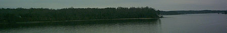
Piankatank River
Encyclopedia
River
A river is a natural watercourse, usually freshwater, flowing towards an ocean, a lake, a sea, or another river. In a few cases, a river simply flows into the ground or dries up completely before reaching another body of water. Small rivers may also be called by several other names, including...
in the U.S. state
U.S. state
A U.S. state is any one of the 50 federated states of the United States of America that share sovereignty with the federal government. Because of this shared sovereignty, an American is a citizen both of the federal entity and of his or her state of domicile. Four states use the official title of...
of Virginia
Virginia
The Commonwealth of Virginia , is a U.S. state on the Atlantic Coast of the Southern United States. Virginia is nicknamed the "Old Dominion" and sometimes the "Mother of Presidents" after the eight U.S. presidents born there...
. Located on the Middle Peninsula
Middle Peninsula
The Middle Peninsula is the second of three large peninsulas on the western shore of Chesapeake Bay in Virginia, in the United States. It lies between the Northern Neck and the Virginia Peninsula. This peninsula is bounded by the Rappahannock River on the north and the York River on the south...
, between the Rappahannock
Rappahannock River
The Rappahannock River is a river in eastern Virginia, in the United States, approximately in length. It traverses the entire northern part of the state, from the Blue Ridge Mountains in the west, across the Piedmont, to the Chesapeake Bay, south of the Potomac River.An important river in American...
and York
York River (Virginia)
The York River is a navigable estuary, approximately long, in eastern Virginia in the United States. It ranges in width from at its head to near its mouth on the west side of Chesapeake Bay. Its watershed drains an area including portions of 17 counties of the coastal plain of Virginia north...
rivers, it was the site of numerous actions during the American Civil War
American Civil War
The American Civil War was a civil war fought in the United States of America. In response to the election of Abraham Lincoln as President of the United States, 11 southern slave states declared their secession from the United States and formed the Confederate States of America ; the other 25...
.
The Piankatank is primarily a tidal river
Estuary
An estuary is a partly enclosed coastal body of water with one or more rivers or streams flowing into it, and with a free connection to the open sea....
of the Chesapeake Bay
Chesapeake Bay
The Chesapeake Bay is the largest estuary in the United States. It lies off the Atlantic Ocean, surrounded by Maryland and Virginia. The Chesapeake Bay's drainage basin covers in the District of Columbia and parts of six states: New York, Pennsylvania, Delaware, Maryland, Virginia, and West...
. The head of the river meets with the mouth of Dragon Swamp
Dragon Swamp
Dragon Swamp, also known as Dragon Run, is a stream in the U.S. state of Virginia, flowing through King and Queen, Essex, Middlesex, and Gloucester counties. It is the main freshwater tributary of the Piankatank River.-References:...
. Bordered by Mathews
Mathews County, Virginia
As of the census of 2010, there were 8,978 people, 3,932 households, and 2,823 families residing in the county. The population density was 108 people per square mile . There were 5,333 housing units at an average density of 62 per square mile...
and Gloucester
Gloucester County, Virginia
Gloucester County is within the Commonwealth of Virginia in the Hampton Roads metropolitan area in the USA. Formed in 1651 in the Virginia Colony, the county was named for Henry Stuart, Duke of Gloucester, third son of King Charles I of Great Britain. Located in the Middle Peninsula region, it...
counties to the south and Middlesex County
Middlesex County, Virginia
As of the census of 2000, there were 9,932 people, 4,253 households, and 2,913 families residing in the county. The population density was 76 people per square mile . There were 6,362 housing units at an average density of 49 per square mile...
to the north, the Piankatank is crossed only by Virginia State Route 3
Virginia State Route 3
State Route 3 is a primary state highway in the U.S. state of Virginia that extends from the town of Culpeper south and eastwardly to Gloucester in Virginia's Middle Peninsula region...
approximately 8 miles (13 km) upriver of its mouth.