

Physical impacts of climate change
Encyclopedia
This article is about the physical impacts of climate change
. For some of these physical impacts, their effect on social and economic systems are also described.
, which is predicted to weaken in the northern hemisphere as the polar region warms more than the rest of the hemisphere.
s would very likely increase. Other likely changes are listed below:
Storm strength leading to extreme weather is increasing, such as the power dissipation index of hurricane intensity. Kerry Emanuel
writes that hurricane power dissipation is highly correlated with temperature, reflecting global warming
. However, a further study by Emanuel using current model output concluded that the increase in power dissipation in recent decades cannot be completely attributed to global warming. Hurricane modeling has produced similar results, finding that hurricanes, simulated under warmer, high-CO2 conditions, are more intense, however, hurricane frequency will be reduced. Worldwide, the proportion of hurricanes reaching categories 4 or 5 – with wind speeds above 56 metres per second – has risen from 20% in the 1970s to 35% in the 1990s. Precipitation hitting the US from hurricanes has increased by 7% over the 20th century. The extent to which this is due to global warming as opposed to the Atlantic Multidecadal Oscillation
is unclear. Some studies have found that the increase in sea surface temperature
may be offset by an increase in wind shear
, leading to little or no change in hurricane activity. Hoyos et al. (2006) have linked the increasing trend in number of category 4 and 5 hurricanes for the period 1970–2004 directly to the trend in sea surface temperatures.
Increases in catastrophes resulting from extreme weather are mainly caused by increasing population densities, and anticipated future increases are similarly dominated by societal change rather than climate change. The World Meteorological Organization
explains that “though there is evidence both for and against the existence of a detectable anthropogenic signal in the tropical cyclone climate record to date, no firm conclusion can be made on this point.” They also clarified that “no individual tropical cyclone can be directly attributed to climate change.”
Thomas Knutson
and Robert E. Tuleya of NOAA stated in 2004 that warming induced by greenhouse gas
may lead to increasing occurrence of highly destructive category-5 storms. In 2008, Knutson et al. found that Atlantic hurricane and tropical storm frequencies could reduce under future greenhouse-gas-induced warming. Vecchi and Soden find that wind shear
, the increase of which acts to inhibit tropical cyclone
s, also changes in model-projections of global warming. There are projected increases of wind shear
in the tropical Atlantic and East Pacific associated with the deceleration of the Walker circulation
, as well as decreases of wind shear in the western and central Pacific. The study does not make claims about the net effect on Atlantic and East Pacific hurricanes of the warming and moistening atmospheres, and the model-projected increases in Atlantic wind shear.
A substantially higher risk of extreme weather does not necessarily mean a noticeably greater risk of slightly-above-average weather. However, the evidence is clear that severe weather and moderate rainfall are also increasing. Increases in temperature are expected to produce more intense convection over land and a higher frequency of the most severe storms.
 Over the course of the 20th century, evaporation rates have reduced worldwide; this is thought by many to be explained by global dimming
. As the climate grows warmer and the causes of global dimming are reduced, evaporation
will increase due to warmer oceans. Because the world is a closed system this will cause heavier rainfall, with more erosion
. This erosion, in turn, can in vulnerable tropical areas (especially in Africa) lead to desertification
. On the other hand, in other areas, increased rainfall lead to growth of forests in dry desert areas.
Scientists have found evidence that increased evaporation could result in more extreme weather
as global warming progresses. The IPCC Third Annual Report says: "...global average water vapor concentration and precipitation are projected to increase during the 21st century. By the second half of the 21st century, it is likely that precipitation will have increased over northern mid- to high latitudes and Antarctica in winter. At low latitudes there are both regional increases and decreases over land areas. Larger year to year variations in precipitation are very likely over most areas where an increase in mean precipitation is projected."
, is to overwhelm flood control infrastructure.
explains, “recent increase in societal impact from tropical cyclones has largely been caused by rising concentrations of population and infrastructure in coastal regions.” Pielke et al. (2008) normalized mainland U.S. hurricane damage from 1900–2005 to 2005 values and found no remaining trend of increasing absolute damage. The 1970s and 1980s were notable because of the extremely low amounts of damage compared to other decades. The decade 1996–2005 has the second most damage among the past 11 decades, with only the decade 1926–1935 surpassing its costs. The most damaging single storm is the 1926 Miami hurricane
, with $157 billion of normalized damage.
The American Insurance Journal predicted that “catastrophe losses should be expected to double roughly every 10 years because of increases in construction costs, increases in the number of structures and changes in their characteristics.” The Association of British Insurers has stated that limiting carbon emissions would avoid 80% of the projected additional annual cost of tropical cyclones by the 2080s. The cost is also increasing partly because of building in exposed areas such as coasts and floodplains. The ABI claims that reduction of the vulnerability to some inevitable effects of climate change, for example through more resilient buildings and improved flood defences, could also result in considerable cost-savings in the longterm.
observed climate change. They concluded that since the middle of the 20th century, it was likely that human influences had significantly contributed to surface temperature increases in every continent except Antarctica. The magazine Scientific American
reported http://www.scientificamerican.com/article.cfm?id=top-10-places-already-affected-by-climate-change on December 23, 2008, that the 10 places most affected by climate change were Darfur
, the Gulf Coast, Italy
, northern Europe
, the Great Barrier Reef
, island nation
s, Washington, D.C.
, the Northwest Passage
, the Alps
, and Uganda
.
region (home to 4,000,000 people) has experienced a temperature rise of 1 °C to 3 °C (1.8 °F to 5.4 °F) over the last 50 years. Canada, Alaska
and Russia are experiencing initial melting of permafrost
. This may disrupt ecosystems and by increasing bacterial activity in the soil lead to these areas becoming carbon sources instead of carbon sinks. A study (published in Science) of changes to eastern Siberia
's permafrost suggests that it is gradually disappearing in the southern regions, leading to the loss of nearly 11% of Siberia's nearly 11,000 lakes since 1971. At the same time, western Siberia is at the initial stage where melting permafrost is creating new lakes, which will eventually start disappearing as in the east. Furthermore, permafrost melting will eventually cause methane release from melting permafrost peat bogs.
but cooling in the stratosphere
and mesosphere
. In addition, a collapse of the thermosphere
has been observed as a possible result in part due to increased carbon dioxide concentrations, the strongest cooling and contraction occurring in that layer during solar minimum
. The most recent contraction in 2008-2009 was the largest such collapse since at least 1967.
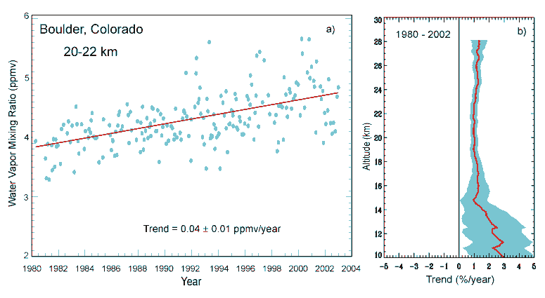
Recent evidence suggests that warming of the tropical oceans since a "tipping point
" in 2000 may have acted as a negative feedback
, reducing the observed warming during the 2000s. As warming and evaporation above the Pacific Ocean, temperatures in the lower stratosphere near the tropopause
declined due to both greenhouse gases and ozone-depleting substances, reducing water vapor
levels and removing its warming effect, with vapor concentrations below 2.2 ppmv as measured by the HALOE instrument on the Upper Atmosphere Research Satellite
, in the lower stratosphere of the tropics between 5°N - 5°S first being observed since 2001, although a reversal in this pattern is also likely. The water vapor in the stratosphere arrives through tall thunderstorm
s, while 15% of this vapor is delivered by tropical cyclone
s, and through chemical breakdown of methane
into water vapor and carbon dioxide, both of which are greenhouse gases. The vapor is frozen out of the stratosphere as more of the water is subjected to temperatures that freeze it out of the stratosphere. Water vapor concentrations in the lower stratosphere have declined by 10% (0.4 ppmv) since 2000, reducing warming during the decade by 25%. A rapid cooling of 4 °C to 6 °C also occurred in the lower stratosphere in the mid-1990s, while the rate of ocean warming increased. During the 1990s
, increased stratospheric water vapor led to a 30% increase in warming. After 2000, the sea surface temperature
s of the tropical Western Pacific, where a warm pool of water exists and where temperatures are heavily influenced by ENSO
, between 10°N - 10°S and 139° - 171° longitude became anti-correlated with temperatures at the tropopause
in the same latitudes between 171° - 200° longitude, both measured since the early 1980s
; although the correlation had been previously positive, since 2000 the SST anomalies increased while tropopause temperatures decreased. A sharp increase in average SSTs within the Western Pacific warm pool by more than 0.25 °C in 2000, which has since stabilized, occurred as the "cold point" temperature of the study area at the tropopause experienced a significant reduction. This resulted in less water vapor from tropical thunderstorms entering the stratosphere. However, prior to 2000, increases in average Western Pacific SSTs had resulted in increases in tropopause cold point temperatures. These findings potentially support the negative feedback "Iris hypothesis
".
Using the A2 SRES emissions scenario, Schneider et al. (2007:789) found that this effect led to additional warming by 2100, relative to the 1990-2000 period, of 0.1 to 1.5 °C. This estimate was made with high confidence. The climate projections made in the IPCC Forth Assessment Report of 1.1 to 6.4 °C account for this feedback effect. On the other hand, with medium confidence, Schneider et al. (2007) commented that additional releases of GHGs were possible from permafrost, peat lands, wetlands, and large stores of marine hydrates at high latitudes.
are ice-like deposits containing a mixture of water and gas, the most common gas of which is methane (Maslin, 2004:1). Gas hydrates are stable under high pressures and at relatively low temperatures and are found underneath the oceans and permafrost regions. Future warming at intermediate depths in the world's oceans, as predicted by climate models, will tend to destabilize gas hydrates resulting in the release of large quantities of methane. On the other hand, projected rapid sea level rise
in the coming centuries associated with global warming will tend to stabilize marine gas hydrate deposits.
Unanimous agreement was found among the models that future climate change will reduce the efficiency of the land and ocean carbon cycle to absorb human-induced CO2. As a result, a larger fraction of human-induced CO2 will stay airborne if climate change controls the carbon cycle. By the end of the 21st century, this additional CO2 in the atmosphere varied between 20 and 220 ppm for the two extreme models, with most models lying between 50 and 100 ppm. This additional CO2 led to a projected increase in warming of between 0.1 and 1.5 °C.
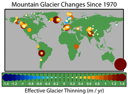 IPCC (2007a:5) found that, on average, mountain glaciers and snow cover had decreased in both the northern and southern hemispheres. This widespread decrease in glaciers and ice caps has contributed to observed sea level rise. With very high or high confidence, IPCC (2007d:11) made a number of predictions relating to future changes in glaciers:
In historic times, glaciers grew during a cool period from about 1550 to 1850 known as the Little Ice Age
. Subsequently, until about 1940, glaciers around the world retreated as the climate warmed. Glacier retreat
declined and reversed in many cases from 1950 to 1980 as a slight global cooling occurred. Since 1980, glacier retreat has become increasingly rapid and ubiquitous, and has threatened the existence of many of the glaciers of the world. This process has increased markedly since 1995.
Excluding the ice cap
s and ice sheet
s of the Arctic and Antarctic, the total surface area of glacier
s worldwide has decreased by 50% since the end of the 19th century. Currently glacier retreat rates and mass balance losses have been increasing in the Andes
, Alps
, Pyrenees
, Himalayas
, Rocky Mountains
and North Cascades
.
The loss of glaciers not only directly causes landslides, flash floods and glacial lake
overflow, but also increases annual variation in water flows in rivers. Glacier runoff declines in the summer as glaciers decrease in size, this decline is already observable in several regions. Glaciers retain water on mountains in high precipitation years, since the snow cover accumulating on glaciers protects the ice from melting. In warmer and drier years, glaciers offset the lower precipitation amounts with a higher meltwater input.
Of particular importance are the Hindu Kush
and Himalayan glacial melts that comprise the principal dry-season water source of many of the major rivers of the Central
, South
, East
and Southeast Asia
n mainland. Increased melting would cause greater flow for several decades, after which "some areas of the most populated regions on Earth are likely to 'run out of water'" as source glaciers are depleted. The Tibetan Plateau
contains the world's third-largest store of ice. Temperatures there are rising four times faster than in the rest of China, and glacial retreat is at a high speed compared to elsewhere in the world.
According to a Reuters report, the Himalayan
glaciers that are the sources of Asia's biggest rivers—Ganges, Indus, Brahmaputra, Yangtze, Mekong
, Salween and Yellow
—could diminish as temperatures rise. Approximately 2.4 billion people live in the drainage basin
of the Himalayan rivers. India, China, Pakistan
, Bangladesh
, Nepal
and Myanmar
could experience floods followed by drought
s in coming decades. In India alone, the Ganges provides water for drinking and farming for more than 500 million people. It has to be acknowledged, however, that increased seasonal runoff of Himalayan glaciers led to increased agricultural production in northern India throughout the 20th century.
The recession of mountain glaciers, notably in Western North America, Franz-Josef Land, Asia, the Alps, the Pyrenees, Indonesia and Africa, and tropical and sub-tropical regions of South America, has been used to provide qualitative support to the rise in global temperatures since the late 19th century. Many glaciers are being lost to melting further raising concerns about future local water resources in these glaciated areas. In Western North America the 47 North Cascade glaciers observed all are retreating.
 Despite their proximity and importance to human populations
, the mountain and valley glaciers of temperate latitudes amount to a small fraction of glacial ice on the earth. About 99% is in the great ice sheets of polar and subpolar Antarctica and Greenland. These continuous continental-scale ice sheets, 3 kilometres (1.9 mi) or more in thickness, cap the polar and subpolar land masses. Like rivers flowing from an enormous lake, numerous outlet glaciers transport ice from the margins of the ice sheet to the ocean.
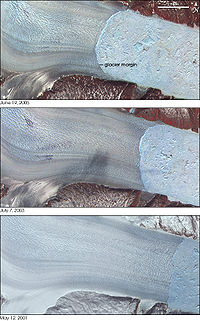
Glacier retreat has been observed in these outlet glaciers, resulting in an increase of the ice flow rate. In Greenland
the period since the year 2000 has brought retreat to several very large glaciers that had long been stable. Three glaciers that have been researched, Helheim, Jakobshavn Isbræ
and Kangerdlugssuaq Glaciers, jointly drain more than 16% of the Greenland Ice Sheet
. Satellite images and aerial photographs from the 1950s and 1970s show that the front of the glacier had remained in the same place for decades. But in 2001 it began retreating rapidly, retreating 7.2 km (4.5 mi) between 2001 and 2005. It has also accelerated from 20 m (65.6 ft)/day to 32 m (105 ft)/day. Jakobshavn Isbræ in western Greenland had been moving at speeds of over 24 m (78.7 ft)/day with a stable terminus since at least 1950. The glacier's ice tongue began to break apart in 2000, leading to almost complete disintegration in 2003, while the retreat rate increased to over 30 m (98.4 ft)/day.
. Furthermore, as the temperature of the oceans increases, they become less able to absorb excess CO2. Global warming is projected to have a number of effects on the oceans. Ongoing effects include rising sea levels due to thermal expansion and melting of glaciers and ice sheets, and warming of the ocean surface, leading to increased temperature stratification. Other possible effects include large-scale changes in ocean circulation.
IPCC (2007a:13, 14) projected sea level rise to the end of the 21st century using the SRES
emission scenarios. Across the six SRES marker scenarios, sea level was projected to rise by 18 to 59 cm (7.1 to 23.2 inches). This projection was for the time period 2090-2099, with the increase in level relative to average sea levels over the 1980-1999 period. Due to a lack of scientific understanding, this sea level rise estimate does not include all of the possible contributions of ice sheets.
With increasing average global temperature, the water
in the oceans expands in volume, and additional water enters them which had previously been locked up on land in glaciers and ice sheets. The Greenland
and the Antarctic ice sheet
s are major ice masses, and at least the former of which may suffer irreversible decline. For most glaciers worldwide, an average volume loss of 60% until 2050 is predicted. Meanwhile, the estimated total ice melting rate over Greenland is 239 +/- 23 km³ (57.3 +/- 5.5 ) per year, mostly from East Greenland. The Antarctic ice sheet, however, is expected to grow during the 21st century because of increased precipitation. Under the IPCC Special Report on Emission Scenario (SRES) A1B, by the mid-2090s global sea level will reach 0.22 to 0.44 m (8.7 to 17.3 in) above 1990 levels, and is currently rising at about 4 mm (0.15748031496063 in) per year. Since 1900, the sea level has risen at an average of 1.7 mm (0.0669291338582677 in) per year; since 1993, satellite
altimetry from TOPEX/Poseidon
indicates a rate of about 3 mm (0.118110236220472 in) per year.
The sea level has risen more than 120 metres (393.7 ft) since the Last Glacial Maximum
about 20,000 years ago. The bulk of that occurred before 7000 years ago. Global temperature declined after the Holocene Climatic Optimum
, causing a sea level lowering of 0.7 +/- 0.1 m (27.6 +/- 3.9 in) between 4000 and 2500 years before present. From 3000 years ago to the start of the 19th century, sea level was almost constant, with only minor fluctuations. However, the Medieval Warm Period
may have caused some sea level rise; evidence has been found in the Pacific Ocean for a rise to perhaps 0.9 m (3 ft) above present level in 700 BP.
In a paper published in 2007, the climatologist James E. Hansen et al. claimed that ice at the poles does not melt in a gradual and linear fashion, but that another according to the geological record, the ice sheet
s can suddenly destabilize when a certain threshold is exceeded. In this paper Hansen et al. state:
Sea level rise due to the collapse of an ice sheet would be distributed nonuniformly across the globe. The loss of mass in the region around the ice sheet would decrease the gravitational potential there, reducing the amount of local sea level rise or even causing local sea level fall. The loss of the localized mass would also change the moment of inertia
of the Earth, as flow in the Earth's mantle will require 10–15 thousand years to make up the mass deficit. This change in the moment of inertia results in true polar wander
, in which the Earth's rotational axis remains fixed with respect to the sun, but the rigid sphere of the Earth rotates with respect to it. This changes the location of the equatorial bulge
of the Earth and further affects the geoid
, or global potential field. A 2009 study of the effects of collapse of the West Antarctic Ice Sheet
shows the result of both of these effects. Instead of a global 5-meter sea level rise, western Antarctica would experience approximately 25 centimeters of sea level fall, while the United States, parts of Canada, and the Indian Ocean, would experience up to 6.5 meters of sea level rise.
A paper published in 2008 by a group of researchers at the University of Wisconsin led by Anders Carlson used the deglaciation of North America at 9000 years before present as an analogue to predict sea level rise of 1.3 meters in the next century, which is also much higher than the IPCC predictions. However, models of glacial flow in the smaller present-day ice sheets show that a probable maximum value for sea level rise in the next century is 80 centimeters, based on limitations on how quickly ice can flow below the equilibrium line altitude and to the sea.
rose by 0.17 °C (0.31 °F) between the 1950s and the 1980s, nearly twice the rate for the world's oceans as a whole. As well as having effects on ecosystems (e.g. by melting sea ice, affecting algae that grow on its underside), warming reduces the ocean's ability to absorb CO2.
in the atmosphere, and is not a direct consequence of global warming
. The oceans soak up much of the CO2 produced by living organisms, either as dissolved gas, or in the skeletons of tiny marine creatures that fall to the bottom to become chalk or limestone. Oceans currently absorb about one tonne of CO2 per person per year. It is estimated that the oceans have absorbed around half of all CO2 generated by human activities since 1800 (118 ± 19 petagrams of carbon from 1800 to 1994).
In water, CO2 becomes a weak carbonic acid
, and the increase in the greenhouse gas since the Industrial Revolution
has already lowered the average pH
(the laboratory measure of acidity) of seawater by 0.1 units, to 8.2. Predicted emissions could lower the pH by a further 0.5 by 2100, to a level probably not seen for hundreds of millennia and, critically, at a rate of change probably 100 times greater than at any time over this period.
There are concerns that increasing acidification could have a particularly detrimental effect on coral
s (16% of the world's coral reefs have died from bleaching caused by warm water in 1998, which coincidentally was the warmest year ever recorded) and other marine organisms with calcium carbonate
shells.
In November 2009 an article in Science
by scientists at Canada
's Department of Fisheries and Oceans reported they had found very low levels of the building blocks for the calcium chloride that forms plankton
shells in the Beaufort Sea
.
Fiona McLaughlin
, one of the DFO authors, asserted that the increasing acidification of the Arctic Ocean was close to the point it would start dissolving the walls of existing plankton: "[the] Arctic ecosystem may be risk. In actual fact, they'll dissolve the shells."
Because cold water absorbs CO2 more readily than warmer water the acidification is more severe in the polar regions. McLaughlin predicted the acidified water would travel to the North Atlantic within the next ten years.
and Britain
that are warmed by the North Atlantic drift
.
The chances of this near-term collapse of the circulation are unclear; there is some evidence for the short-term stability of the Gulf Stream and possible weakening of the North Atlantic drift. However, the degree of weakening, and whether it will be sufficient to shut down the circulation, is under debate. As yet, no cooling has been found in northern Europe or nearby seas. Lenton et al. found that "simulations clearly pass a THC tipping point this century".
IPCC (2007b:17) concluded that a slowing of the Meridional Overturning Circulation
would very likely occur this century. Due to global warming, temperatures across the Atlantic and Europe were still projected to increase.
have a significant effect on climate. One source of such aerosol
s is the sulfur cycle
, where plankton
release gases such as DMS
which eventually becomes oxidised
to sulfur dioxide
in the atmosphere. Disruption to the oceans as a result of ocean acidification
or disruptions to the thermohaline circulation
may result in disruption of the sulfur cycle
, thus reducing its cooling effect on the planet through the creation of stratospheric sulfur aerosols
.
. Reduction in ice cover reduces the confining pressure exerted on the volcano, increasing deviatoric stresses and potentially causing the volcano to erupt. This reduction of pressure can also cause decompression melting of material in the mantle, resulting in the generation of more magma. Researchers in Iceland have shown that the rate of volcanic rock production there following deglaciation (10,000 to 4500 years before present
) was 20–30 times greater than that observed after 2900 years before present. While the original study addresses the first reason for increased volcanism (reduced confining pressure), scientists have more recently shown that these lavas have unusually high trace element
concentrations, indicative of increased melting in the mantle. This work in Iceland has been corroborated by a study in California, in which scientists found a strong correlation between volcanism and periods of global deglaciation. The effects of current sea level rise
could include increased crustal
stress at the base of coastal volcanoes from a rise in the volcano's water table
(and the associated saltwater intrusion
), while the mass from extra water could activate dormant seismic faults around volcanoes. In addition, the wide-scale displacement of water from melting in places such as West Antarctica
is likely to slightly alter the Earth's rotational period and may shift its axial tilt
on the scale of hundreds of metres, inducing further crustal stress changes.
Current melting of ice is predicted to increase the size and frequency of volcanic eruptions. In particular, lateral collapse events at stratovolcano
es are likely to increase, and there are potential positive feedbacks between the removal of ice and magmatism.
Climate change
Climate change is a significant and lasting change in the statistical distribution of weather patterns over periods ranging from decades to millions of years. It may be a change in average weather conditions or the distribution of events around that average...
. For some of these physical impacts, their effect on social and economic systems are also described.
Definition of climate change
This article refers to reports produced by the IPCC. In their usage, "climate change" refers to a change in the state of the climate that can be identified by changes in the mean and/or variability of its properties, and that persists for extended periods, typically decades or longer (IPCC, 2007d:30). The climate change referred to may be due to natural causes or the result of human activity.Effects on weather
Increasing temperature is likely to lead to increasing precipitation but the effects on storms are less clear. Extratropical storms partly depend on the temperature gradientTemperature gradient
A temperature gradient is a physical quantity that describes in which direction and at what rate the temperature changes the most rapidly around a particular location. The temperature gradient is a dimensional quantity expressed in units of degrees per unit length...
, which is predicted to weaken in the northern hemisphere as the polar region warms more than the rest of the hemisphere.
Fire
Fire is a major agent for conversion of biomass and soil organic matter to CO2 (Denman et al., 2007:527). There is a large potential for future alteration in the terrestrial carbon balance through altered fire regimes. With high confidence, Schneider et al. (2007:789) predicted that:- An increase in global mean temperature of about 0 to 2 °C by 2100 relative to the 1990-2000 period would result in increased fire frequency and intensity in many areas.
- An increase in the region of 2 °C or above would lead to increased frequency and intensity of fires.
Weather
IPCC (2007a:8) predicted that in the future, over most land areas, the frequency of warm spells or heat waveHeat wave
A heat wave is a prolonged period of excessively hot weather, which may be accompanied by high humidity. There is no universal definition of a heat wave; the term is relative to the usual weather in the area...
s would very likely increase. Other likely changes are listed below:
- Increased areas will be affected by droughtDroughtA drought is an extended period of months or years when a region notes a deficiency in its water supply. Generally, this occurs when a region receives consistently below average precipitation. It can have a substantial impact on the ecosystem and agriculture of the affected region...
- There will be increased intense tropical cycloneTropical cycloneA tropical cyclone is a storm system characterized by a large low-pressure center and numerous thunderstorms that produce strong winds and heavy rain. Tropical cyclones strengthen when water evaporated from the ocean is released as the saturated air rises, resulting in condensation of water vapor...
activity - There will be increased incidences of extreme high sea level (excluding tsunamiTsunamiA tsunami is a series of water waves caused by the displacement of a large volume of a body of water, typically an ocean or a large lake...
s)
Storm strength leading to extreme weather is increasing, such as the power dissipation index of hurricane intensity. Kerry Emanuel
Kerry Emanuel
Kerry Emanuel is an American professor of meteorology currently working at the Massachusetts Institute of Technology in Cambridge. In particular he has specialized in atmospheric convection and the mechanisms acting to intensify hurricanes. He coined the term "hypercane" in 1994. In 2007, he was...
writes that hurricane power dissipation is highly correlated with temperature, reflecting global warming
Global warming
Global warming refers to the rising average temperature of Earth's atmosphere and oceans and its projected continuation. In the last 100 years, Earth's average surface temperature increased by about with about two thirds of the increase occurring over just the last three decades...
. However, a further study by Emanuel using current model output concluded that the increase in power dissipation in recent decades cannot be completely attributed to global warming. Hurricane modeling has produced similar results, finding that hurricanes, simulated under warmer, high-CO2 conditions, are more intense, however, hurricane frequency will be reduced. Worldwide, the proportion of hurricanes reaching categories 4 or 5 – with wind speeds above 56 metres per second – has risen from 20% in the 1970s to 35% in the 1990s. Precipitation hitting the US from hurricanes has increased by 7% over the 20th century. The extent to which this is due to global warming as opposed to the Atlantic Multidecadal Oscillation
Atlantic Multidecadal Oscillation
The Atlantic multidecadal oscillation is a mode of variability occurring in the North Atlantic Ocean and which has its principal expression in the sea surface temperature field...
is unclear. Some studies have found that the increase in sea surface temperature
Sea surface temperature
Sea surface temperature is the water temperature close to the oceans surface. The exact meaning of surface varies according to the measurement method used, but it is between and below the sea surface. Air masses in the Earth's atmosphere are highly modified by sea surface temperatures within a...
may be offset by an increase in wind shear
Wind shear
Wind shear, sometimes referred to as windshear or wind gradient, is a difference in wind speed and direction over a relatively short distance in the atmosphere...
, leading to little or no change in hurricane activity. Hoyos et al. (2006) have linked the increasing trend in number of category 4 and 5 hurricanes for the period 1970–2004 directly to the trend in sea surface temperatures.
Increases in catastrophes resulting from extreme weather are mainly caused by increasing population densities, and anticipated future increases are similarly dominated by societal change rather than climate change. The World Meteorological Organization
World Meteorological Organization
The World Meteorological Organization is an intergovernmental organization with a membership of 189 Member States and Territories. It originated from the International Meteorological Organization , which was founded in 1873...
explains that “though there is evidence both for and against the existence of a detectable anthropogenic signal in the tropical cyclone climate record to date, no firm conclusion can be made on this point.” They also clarified that “no individual tropical cyclone can be directly attributed to climate change.”
Thomas Knutson
Thomas Knutson
Thomas Knutson is a climate modeller at the US Geophysical Fluid Dynamics Laboratory, a division of the National Oceanic and Atmospheric Administration . In 2004, he published a paper suggesting that increases in atmospheric carbon dioxide would lead to more intense hurricanes. This finding was...
and Robert E. Tuleya of NOAA stated in 2004 that warming induced by greenhouse gas
Greenhouse gas
A greenhouse gas is a gas in an atmosphere that absorbs and emits radiation within the thermal infrared range. This process is the fundamental cause of the greenhouse effect. The primary greenhouse gases in the Earth's atmosphere are water vapor, carbon dioxide, methane, nitrous oxide, and ozone...
may lead to increasing occurrence of highly destructive category-5 storms. In 2008, Knutson et al. found that Atlantic hurricane and tropical storm frequencies could reduce under future greenhouse-gas-induced warming. Vecchi and Soden find that wind shear
Wind shear
Wind shear, sometimes referred to as windshear or wind gradient, is a difference in wind speed and direction over a relatively short distance in the atmosphere...
, the increase of which acts to inhibit tropical cyclone
Tropical cyclone
A tropical cyclone is a storm system characterized by a large low-pressure center and numerous thunderstorms that produce strong winds and heavy rain. Tropical cyclones strengthen when water evaporated from the ocean is released as the saturated air rises, resulting in condensation of water vapor...
s, also changes in model-projections of global warming. There are projected increases of wind shear
Wind shear
Wind shear, sometimes referred to as windshear or wind gradient, is a difference in wind speed and direction over a relatively short distance in the atmosphere...
in the tropical Atlantic and East Pacific associated with the deceleration of the Walker circulation
Walker circulation
The Walker circulation, also known as the Walker cell, is a conceptual model of the air flow in the tropics in the lower atmosphere . According to this model parcels of air follow a closed circulation in the zonal and vertical directions...
, as well as decreases of wind shear in the western and central Pacific. The study does not make claims about the net effect on Atlantic and East Pacific hurricanes of the warming and moistening atmospheres, and the model-projected increases in Atlantic wind shear.
A substantially higher risk of extreme weather does not necessarily mean a noticeably greater risk of slightly-above-average weather. However, the evidence is clear that severe weather and moderate rainfall are also increasing. Increases in temperature are expected to produce more intense convection over land and a higher frequency of the most severe storms.
Increased evaporation
Global dimming
Global dimming is the gradual reduction in the amount of global direct irradiance at the Earth's surface that was observed for several decades after the start of systematic measurements in the 1950s. The effect varies by location, but worldwide it has been estimated to be of the order of a 4%...
. As the climate grows warmer and the causes of global dimming are reduced, evaporation
Evaporation
Evaporation is a type of vaporization of a liquid that occurs only on the surface of a liquid. The other type of vaporization is boiling, which, instead, occurs on the entire mass of the liquid....
will increase due to warmer oceans. Because the world is a closed system this will cause heavier rainfall, with more erosion
Erosion
Erosion is when materials are removed from the surface and changed into something else. It only works by hydraulic actions and transport of solids in the natural environment, and leads to the deposition of these materials elsewhere...
. This erosion, in turn, can in vulnerable tropical areas (especially in Africa) lead to desertification
Desertification
Desertification is the degradation of land in drylands. Caused by a variety of factors, such as climate change and human activities, desertification is one of the most significant global environmental problems.-Definitions:...
. On the other hand, in other areas, increased rainfall lead to growth of forests in dry desert areas.
Scientists have found evidence that increased evaporation could result in more extreme weather
Weather
Weather is the state of the atmosphere, to the degree that it is hot or cold, wet or dry, calm or stormy, clear or cloudy. Most weather phenomena occur in the troposphere, just below the stratosphere. Weather refers, generally, to day-to-day temperature and precipitation activity, whereas climate...
as global warming progresses. The IPCC Third Annual Report says: "...global average water vapor concentration and precipitation are projected to increase during the 21st century. By the second half of the 21st century, it is likely that precipitation will have increased over northern mid- to high latitudes and Antarctica in winter. At low latitudes there are both regional increases and decreases over land areas. Larger year to year variations in precipitation are very likely over most areas where an increase in mean precipitation is projected."
Increased freshwater flow
Research based on satellite observations, published in October, 2010, shows an increase in the flow of freshwater into the world's oceans, partly from melting ice and partly from increased precipitation driven by an increase in global ocean evaporation. The increase in global freshwater flow, based on data from 1994 to 2006, was about 18%. Much of the increase is in areas which already experience high rainfall. One effect, as perhaps experienced in the 2010 Pakistan floods2010 Pakistan floods
The 2010 Pakistan floods began in late July 2010, resulting from heavy monsoon rains in the Khyber Pakhtunkhwa, Sindh, Punjab and Balochistan regions of Pakistan and affected the Indus River basin. Approximately one-fifth of Pakistan's total land area was underwater, approximately...
, is to overwhelm flood control infrastructure.
Cost of more extreme weather
As the World Meteorological OrganizationWorld Meteorological Organization
The World Meteorological Organization is an intergovernmental organization with a membership of 189 Member States and Territories. It originated from the International Meteorological Organization , which was founded in 1873...
explains, “recent increase in societal impact from tropical cyclones has largely been caused by rising concentrations of population and infrastructure in coastal regions.” Pielke et al. (2008) normalized mainland U.S. hurricane damage from 1900–2005 to 2005 values and found no remaining trend of increasing absolute damage. The 1970s and 1980s were notable because of the extremely low amounts of damage compared to other decades. The decade 1996–2005 has the second most damage among the past 11 decades, with only the decade 1926–1935 surpassing its costs. The most damaging single storm is the 1926 Miami hurricane
1926 Miami Hurricane
The 1926 Miami hurricane was a Category 4 hurricane that devastated Miami in September 1926. The storm also caused significant damage in the Florida Panhandle, the U.S. state of Alabama, and the Bahamas...
, with $157 billion of normalized damage.
The American Insurance Journal predicted that “catastrophe losses should be expected to double roughly every 10 years because of increases in construction costs, increases in the number of structures and changes in their characteristics.” The Association of British Insurers has stated that limiting carbon emissions would avoid 80% of the projected additional annual cost of tropical cyclones by the 2080s. The cost is also increasing partly because of building in exposed areas such as coasts and floodplains. The ABI claims that reduction of the vulnerability to some inevitable effects of climate change, for example through more resilient buildings and improved flood defences, could also result in considerable cost-savings in the longterm.
General effects
In a literature assessment, Hegerl et al. (2007) assessed evidence for attributingAttribution of recent climate change
Attribution of recent climate change is the effort to scientifically ascertain mechanisms responsible for recent changes observed in the Earth's climate...
observed climate change. They concluded that since the middle of the 20th century, it was likely that human influences had significantly contributed to surface temperature increases in every continent except Antarctica. The magazine Scientific American
Scientific American
Scientific American is a popular science magazine. It is notable for its long history of presenting science monthly to an educated but not necessarily scientific public, through its careful attention to the clarity of its text as well as the quality of its specially commissioned color graphics...
reported http://www.scientificamerican.com/article.cfm?id=top-10-places-already-affected-by-climate-change on December 23, 2008, that the 10 places most affected by climate change were Darfur
Darfur
Darfur is a region in western Sudan. An independent sultanate for several hundred years, it was incorporated into Sudan by Anglo-Egyptian forces in 1916. The region is divided into three federal states: West Darfur, South Darfur, and North Darfur...
, the Gulf Coast, Italy
Italy
Italy , officially the Italian Republic languages]] under the European Charter for Regional or Minority Languages. In each of these, Italy's official name is as follows:;;;;;;;;), is a unitary parliamentary republic in South-Central Europe. To the north it borders France, Switzerland, Austria and...
, northern Europe
Northern Europe
Northern Europe is the northern part or region of Europe. Northern Europe typically refers to the seven countries in the northern part of the European subcontinent which includes Denmark, Estonia, Latvia, Lithuania, Norway, Finland and Sweden...
, the Great Barrier Reef
Great Barrier Reef
The Great Barrier Reef is the world'slargest reef system composed of over 2,900 individual reefs and 900 islands stretching for over 2,600 kilometres over an area of approximately...
, island nation
Island nation
An island country is a state whose primary territory consists of one or more islands or parts of islands. As of 2011, 47 of the 193 UN member states are island countries.-Politics:...
s, Washington, D.C.
Washington, D.C.
Washington, D.C., formally the District of Columbia and commonly referred to as Washington, "the District", or simply D.C., is the capital of the United States. On July 16, 1790, the United States Congress approved the creation of a permanent national capital as permitted by the U.S. Constitution....
, the Northwest Passage
Northwest Passage
The Northwest Passage is a sea route through the Arctic Ocean, along the northern coast of North America via waterways amidst the Canadian Arctic Archipelago, connecting the Atlantic and Pacific Oceans...
, the Alps
Alps
The Alps is one of the great mountain range systems of Europe, stretching from Austria and Slovenia in the east through Italy, Switzerland, Liechtenstein and Germany to France in the west....
, and Uganda
Uganda
Uganda , officially the Republic of Uganda, is a landlocked country in East Africa. Uganda is also known as the "Pearl of Africa". It is bordered on the east by Kenya, on the north by South Sudan, on the west by the Democratic Republic of the Congo, on the southwest by Rwanda, and on the south by...
.
Northern hemisphere
In the northern hemisphere, the southern part of the ArcticArctic
The Arctic is a region located at the northern-most part of the Earth. The Arctic consists of the Arctic Ocean and parts of Canada, Russia, Greenland, the United States, Norway, Sweden, Finland, and Iceland. The Arctic region consists of a vast, ice-covered ocean, surrounded by treeless permafrost...
region (home to 4,000,000 people) has experienced a temperature rise of 1 °C to 3 °C (1.8 °F to 5.4 °F) over the last 50 years. Canada, Alaska
Alaska
Alaska is the largest state in the United States by area. It is situated in the northwest extremity of the North American continent, with Canada to the east, the Arctic Ocean to the north, and the Pacific Ocean to the west and south, with Russia further west across the Bering Strait...
and Russia are experiencing initial melting of permafrost
Permafrost
In geology, permafrost, cryotic soil or permafrost soil is soil at or below the freezing point of water for two or more years. Ice is not always present, as may be in the case of nonporous bedrock, but it frequently occurs and it may be in amounts exceeding the potential hydraulic saturation of...
. This may disrupt ecosystems and by increasing bacterial activity in the soil lead to these areas becoming carbon sources instead of carbon sinks. A study (published in Science) of changes to eastern Siberia
Siberia
Siberia is an extensive region constituting almost all of Northern Asia. Comprising the central and eastern portion of the Russian Federation, it was part of the Soviet Union from its beginning, as its predecessor states, the Tsardom of Russia and the Russian Empire, conquered it during the 16th...
's permafrost suggests that it is gradually disappearing in the southern regions, leading to the loss of nearly 11% of Siberia's nearly 11,000 lakes since 1971. At the same time, western Siberia is at the initial stage where melting permafrost is creating new lakes, which will eventually start disappearing as in the east. Furthermore, permafrost melting will eventually cause methane release from melting permafrost peat bogs.
Polar regions
Anisimov et al. (2007) assessed the literature on impacts of climate change in Polar regions. Model projections showed that Arctic terrestrial ecosystems and the active layer (the top layer of soil or rock in permafrost that is subjected to seasonal freezing and thawing) would be a small sink for carbon (i.e., net uptake of carbon) over this century (p. 662). These projections were viewed as being uncertain. It was judged that increased emissions of carbon from thawing of permafrost could occur. This would lead to an amplification of warming.Upper atmosphere
Increased CO2 levels cause warming in the troposphereTroposphere
The troposphere is the lowest portion of Earth's atmosphere. It contains approximately 80% of the atmosphere's mass and 99% of its water vapor and aerosols....
but cooling in the stratosphere
Stratosphere
The stratosphere is the second major layer of Earth's atmosphere, just above the troposphere, and below the mesosphere. It is stratified in temperature, with warmer layers higher up and cooler layers farther down. This is in contrast to the troposphere near the Earth's surface, which is cooler...
and mesosphere
Mesosphere
The mesosphere is the layer of the Earth's atmosphere that is directly above the stratosphere and directly below the thermosphere. In the mesosphere temperature decreases with increasing height. The upper boundary of the mesosphere is the mesopause, which can be the coldest naturally occurring...
. In addition, a collapse of the thermosphere
Thermosphere
The thermosphere is the biggest of all the layers of the Earth's atmosphere directly above the mesosphere and directly below the exosphere. Within this layer, ultraviolet radiation causes ionization. The International Space Station has a stable orbit within the middle of the thermosphere, between...
has been observed as a possible result in part due to increased carbon dioxide concentrations, the strongest cooling and contraction occurring in that layer during solar minimum
Solar minimum
Solar minimum is the period of least solar activity in the solar cycle of the sun. During this time, sunspot and solar flare activity diminishes, and often does not occur for days at a time...
. The most recent contraction in 2008-2009 was the largest such collapse since at least 1967.
Recent evidence suggests that warming of the tropical oceans since a "tipping point
Tipping point (climatology)
A climate tipping point is a point when global climate changes from one stable state to another stable state, in a similar manner to a wine glass tipping over. After the tipping point has been passed, a transition to a new state occurs...
" in 2000 may have acted as a negative feedback
Negative feedback
Negative feedback occurs when the output of a system acts to oppose changes to the input of the system, with the result that the changes are attenuated. If the overall feedback of the system is negative, then the system will tend to be stable.- Overview :...
, reducing the observed warming during the 2000s. As warming and evaporation above the Pacific Ocean, temperatures in the lower stratosphere near the tropopause
Tropopause
The tropopause is the atmospheric boundary between the troposphere and the stratosphere.-Definition:Going upward from the surface, it is the point where air ceases to cool with height, and becomes almost completely dry...
declined due to both greenhouse gases and ozone-depleting substances, reducing water vapor
Water vapor
Water vapor or water vapour , also aqueous vapor, is the gas phase of water. It is one state of water within the hydrosphere. Water vapor can be produced from the evaporation or boiling of liquid water or from the sublimation of ice. Under typical atmospheric conditions, water vapor is continuously...
levels and removing its warming effect, with vapor concentrations below 2.2 ppmv as measured by the HALOE instrument on the Upper Atmosphere Research Satellite
Upper Atmosphere Research Satellite
The Upper Atmosphere Research Satellite was a NASA-operated orbital observatory whose mission was to study the Earth’s atmosphere, particularly the protective ozone layer. The satellite was deployed from Space Shuttle Discovery during the STS-48 mission on September 15, 1991...
, in the lower stratosphere of the tropics between 5°N - 5°S first being observed since 2001, although a reversal in this pattern is also likely. The water vapor in the stratosphere arrives through tall thunderstorm
Thunderstorm
A thunderstorm, also known as an electrical storm, a lightning storm, thundershower or simply a storm is a form of weather characterized by the presence of lightning and its acoustic effect on the Earth's atmosphere known as thunder. The meteorologically assigned cloud type associated with the...
s, while 15% of this vapor is delivered by tropical cyclone
Tropical cyclone
A tropical cyclone is a storm system characterized by a large low-pressure center and numerous thunderstorms that produce strong winds and heavy rain. Tropical cyclones strengthen when water evaporated from the ocean is released as the saturated air rises, resulting in condensation of water vapor...
s, and through chemical breakdown of methane
Methane
Methane is a chemical compound with the chemical formula . It is the simplest alkane, the principal component of natural gas, and probably the most abundant organic compound on earth. The relative abundance of methane makes it an attractive fuel...
into water vapor and carbon dioxide, both of which are greenhouse gases. The vapor is frozen out of the stratosphere as more of the water is subjected to temperatures that freeze it out of the stratosphere. Water vapor concentrations in the lower stratosphere have declined by 10% (0.4 ppmv) since 2000, reducing warming during the decade by 25%. A rapid cooling of 4 °C to 6 °C also occurred in the lower stratosphere in the mid-1990s, while the rate of ocean warming increased. During the 1990s
1990s
File:1990s decade montage.png|From left, clockwise: The Hubble Space Telescope floats in space after it was taken up in 1990; American F-16s and F-15s fly over burning oil fields and the USA Lexie in Operation Desert Storm, also known as the 1991 Gulf War; The signing of the Oslo Accords on...
, increased stratospheric water vapor led to a 30% increase in warming. After 2000, the sea surface temperature
Sea surface temperature
Sea surface temperature is the water temperature close to the oceans surface. The exact meaning of surface varies according to the measurement method used, but it is between and below the sea surface. Air masses in the Earth's atmosphere are highly modified by sea surface temperatures within a...
s of the tropical Western Pacific, where a warm pool of water exists and where temperatures are heavily influenced by ENSO
Enso
Ensō is a Japanese word meaning "circle" and a concept strongly associated with Zen. Ensō is one of the most common subjects of Japanese calligraphy even though it is a symbol and not a character. It symbolizes the Absolute enlightenment, strength, elegance, the Universe, and the void; it can...
, between 10°N - 10°S and 139° - 171° longitude became anti-correlated with temperatures at the tropopause
Tropopause
The tropopause is the atmospheric boundary between the troposphere and the stratosphere.-Definition:Going upward from the surface, it is the point where air ceases to cool with height, and becomes almost completely dry...
in the same latitudes between 171° - 200° longitude, both measured since the early 1980s
1980s
File:1980s decade montage.png|thumb|400px|From left, clockwise: The first Space Shuttle, Columbia, lifted off in 1981; American President Ronald Reagan and Soviet leader Mikhail Gorbachev eased tensions between the two superpowers, leading to the end of the Cold War; The Fall of the Berlin Wall in...
; although the correlation had been previously positive, since 2000 the SST anomalies increased while tropopause temperatures decreased. A sharp increase in average SSTs within the Western Pacific warm pool by more than 0.25 °C in 2000, which has since stabilized, occurred as the "cold point" temperature of the study area at the tropopause experienced a significant reduction. This resulted in less water vapor from tropical thunderstorms entering the stratosphere. However, prior to 2000, increases in average Western Pacific SSTs had resulted in increases in tropopause cold point temperatures. These findings potentially support the negative feedback "Iris hypothesis
Iris hypothesis
The iris hypothesis is a hypothesis proposed by Professor Richard Lindzen in 2001 that suggested increased sea surface temperature in the tropics would result in reduced cirrus clouds and thus more infrared radiation leakage from Earth's atmosphere...
".
Biogeochemical cycles
Climate change can have an effect on the carbon cycle in an interactive "feedback" process . A feedback exists where an initial process triggers changes in a second process that in turn influences the initial process. A positive feedback intensifies the original process, and a negative feedback reduces it (IPCC, 2007d:78). Models suggest that the interaction of the climate system and the carbon cycle is one where the feedback effect is positive (Schneider et al., 2007:792).Using the A2 SRES emissions scenario, Schneider et al. (2007:789) found that this effect led to additional warming by 2100, relative to the 1990-2000 period, of 0.1 to 1.5 °C. This estimate was made with high confidence. The climate projections made in the IPCC Forth Assessment Report of 1.1 to 6.4 °C account for this feedback effect. On the other hand, with medium confidence, Schneider et al. (2007) commented that additional releases of GHGs were possible from permafrost, peat lands, wetlands, and large stores of marine hydrates at high latitudes.
Gas hydrates
Gas hydratesClathrate hydrate
Clathrate hydrates are crystalline water-based solids physically resembling ice, in which small non-polar molecules or polar molecules with large hydrophobic moieties are trapped inside "cages" of hydrogen bonded water molecules...
are ice-like deposits containing a mixture of water and gas, the most common gas of which is methane (Maslin, 2004:1). Gas hydrates are stable under high pressures and at relatively low temperatures and are found underneath the oceans and permafrost regions. Future warming at intermediate depths in the world's oceans, as predicted by climate models, will tend to destabilize gas hydrates resulting in the release of large quantities of methane. On the other hand, projected rapid sea level rise
Current sea level rise
Current sea level rise potentially impacts human populations and the wider natural environment . Global average sea level rose at an average rate of around 1.8 mm per year over 1961 to 2003 and at an average rate of about 3.1 mm per year from 1993 to 2003...
in the coming centuries associated with global warming will tend to stabilize marine gas hydrate deposits.
Carbon cycle
Models have been used to assess the effect that climate change will have on the carbon cycle (Meehl et al., 2007:789-790). In the Coupled Climate-Carbon Cycle Model Intercomparison Project, eleven climate models were used. Observed emissions were used in the models and future emission projections were based on the IPCC SRES A2 emissions scenario.Unanimous agreement was found among the models that future climate change will reduce the efficiency of the land and ocean carbon cycle to absorb human-induced CO2. As a result, a larger fraction of human-induced CO2 will stay airborne if climate change controls the carbon cycle. By the end of the 21st century, this additional CO2 in the atmosphere varied between 20 and 220 ppm for the two extreme models, with most models lying between 50 and 100 ppm. This additional CO2 led to a projected increase in warming of between 0.1 and 1.5 °C.
Glacier retreat and disappearance
- Mountainous areas in Europe will face glacier retreat
- In Latin America, changes in precipitation patterns and the disappearance of glaciers will significantly affect water availability for human consumption, agriculture, and energy production
- In Polar regions, there will be reductions in glacier extent and the thickness of glaciers.
In historic times, glaciers grew during a cool period from about 1550 to 1850 known as the Little Ice Age
Little Ice Age
The Little Ice Age was a period of cooling that occurred after the Medieval Warm Period . While not a true ice age, the term was introduced into the scientific literature by François E. Matthes in 1939...
. Subsequently, until about 1940, glaciers around the world retreated as the climate warmed. Glacier retreat
Retreat of glaciers since 1850
The retreat of glaciers since 1850 affects the availability of fresh water for irrigation and domestic use, mountain recreation, animals and plants that depend on glacier-melt, and in the longer term, the level of the oceans...
declined and reversed in many cases from 1950 to 1980 as a slight global cooling occurred. Since 1980, glacier retreat has become increasingly rapid and ubiquitous, and has threatened the existence of many of the glaciers of the world. This process has increased markedly since 1995.
Excluding the ice cap
Ice cap
An ice cap is an ice mass that covers less than 50 000 km² of land area . Masses of ice covering more than 50 000 km² are termed an ice sheet....
s and ice sheet
Ice sheet
An ice sheet is a mass of glacier ice that covers surrounding terrain and is greater than 50,000 km² , thus also known as continental glacier...
s of the Arctic and Antarctic, the total surface area of glacier
Glacier
A glacier is a large persistent body of ice that forms where the accumulation of snow exceeds its ablation over many years, often centuries. At least 0.1 km² in area and 50 m thick, but often much larger, a glacier slowly deforms and flows due to stresses induced by its weight...
s worldwide has decreased by 50% since the end of the 19th century. Currently glacier retreat rates and mass balance losses have been increasing in the Andes
Andes
The Andes is the world's longest continental mountain range. It is a continual range of highlands along the western coast of South America. This range is about long, about to wide , and of an average height of about .Along its length, the Andes is split into several ranges, which are separated...
, Alps
Alps
The Alps is one of the great mountain range systems of Europe, stretching from Austria and Slovenia in the east through Italy, Switzerland, Liechtenstein and Germany to France in the west....
, Pyrenees
Pyrenees
The Pyrenees is a range of mountains in southwest Europe that forms a natural border between France and Spain...
, Himalayas
Himalayas
The Himalaya Range or Himalaya Mountains Sanskrit: Devanagari: हिमालय, literally "abode of snow"), usually called the Himalayas or Himalaya for short, is a mountain range in Asia, separating the Indian subcontinent from the Tibetan Plateau...
, Rocky Mountains
Rocky Mountains
The Rocky Mountains are a major mountain range in western North America. The Rocky Mountains stretch more than from the northernmost part of British Columbia, in western Canada, to New Mexico, in the southwestern United States...
and North Cascades
North Cascades
The North Cascades are a section of the Cascade Range of western North America. They span the border between the Canadian province of British Columbia and the U.S. state of Washington and are officially named in Canada as the Cascade Mountains...
.
The loss of glaciers not only directly causes landslides, flash floods and glacial lake
Glacial lake
A glacial lake is a lake with origins in a melted glacier. Near the end of the last glacial period, roughly 10,000 years ago, glaciers began to retreat. A retreating glacier often left behind large deposits of ice in hollows between drumlins or hills. As the ice age ended, these melted to create...
overflow, but also increases annual variation in water flows in rivers. Glacier runoff declines in the summer as glaciers decrease in size, this decline is already observable in several regions. Glaciers retain water on mountains in high precipitation years, since the snow cover accumulating on glaciers protects the ice from melting. In warmer and drier years, glaciers offset the lower precipitation amounts with a higher meltwater input.
Of particular importance are the Hindu Kush
Hindu Kush
The Hindu Kush is an mountain range that stretches between central Afghanistan and northern Pakistan. The highest point in the Hindu Kush is Tirich Mir in the Chitral region of Khyber-Pakhtunkhwa, Pakistan.It is the westernmost extension of the Pamir Mountains, the Karakoram Range, and is a...
and Himalayan glacial melts that comprise the principal dry-season water source of many of the major rivers of the Central
Central Asia
Central Asia is a core region of the Asian continent from the Caspian Sea in the west, China in the east, Afghanistan in the south, and Russia in the north...
, South
South Asia
South Asia, also known as Southern Asia, is the southern region of the Asian continent, which comprises the sub-Himalayan countries and, for some authorities , also includes the adjoining countries to the west and the east...
, East
East Asia
East Asia or Eastern Asia is a subregion of Asia that can be defined in either geographical or cultural terms...
and Southeast Asia
Southeast Asia
Southeast Asia, South-East Asia, South East Asia or Southeastern Asia is a subregion of Asia, consisting of the countries that are geographically south of China, east of India, west of New Guinea and north of Australia. The region lies on the intersection of geological plates, with heavy seismic...
n mainland. Increased melting would cause greater flow for several decades, after which "some areas of the most populated regions on Earth are likely to 'run out of water'" as source glaciers are depleted. The Tibetan Plateau
Tibetan Plateau
The Tibetan Plateau , also known as the Qinghai–Tibetan Plateau is a vast, elevated plateau in Central Asia covering most of the Tibet Autonomous Region and Qinghai, in addition to smaller portions of western Sichuan, southwestern Gansu, and northern Yunnan in Western China and Ladakh in...
contains the world's third-largest store of ice. Temperatures there are rising four times faster than in the rest of China, and glacial retreat is at a high speed compared to elsewhere in the world.
According to a Reuters report, the Himalayan
Himalayas
The Himalaya Range or Himalaya Mountains Sanskrit: Devanagari: हिमालय, literally "abode of snow"), usually called the Himalayas or Himalaya for short, is a mountain range in Asia, separating the Indian subcontinent from the Tibetan Plateau...
glaciers that are the sources of Asia's biggest rivers—Ganges, Indus, Brahmaputra, Yangtze, Mekong
Mekong
The Mekong is a river that runs through China, Burma, Laos, Thailand, Cambodia and Vietnam. It is the world's 10th-longest river and the 7th-longest in Asia. Its estimated length is , and it drains an area of , discharging of water annually....
, Salween and Yellow
Yellow
Yellow is the color evoked by light that stimulates both the L and M cone cells of the retina about equally, with no significant stimulation of the S cone cells. Light with a wavelength of 570–590 nm is yellow, as is light with a suitable mixture of red and green...
—could diminish as temperatures rise. Approximately 2.4 billion people live in the drainage basin
Drainage basin
A drainage basin is an extent or an area of land where surface water from rain and melting snow or ice converges to a single point, usually the exit of the basin, where the waters join another waterbody, such as a river, lake, reservoir, estuary, wetland, sea, or ocean...
of the Himalayan rivers. India, China, Pakistan
Pakistan
Pakistan , officially the Islamic Republic of Pakistan is a sovereign state in South Asia. It has a coastline along the Arabian Sea and the Gulf of Oman in the south and is bordered by Afghanistan and Iran in the west, India in the east and China in the far northeast. In the north, Tajikistan...
, Bangladesh
Bangladesh
Bangladesh , officially the People's Republic of Bangladesh is a sovereign state located in South Asia. It is bordered by India on all sides except for a small border with Burma to the far southeast and by the Bay of Bengal to the south...
, Nepal
Nepal
Nepal , officially the Federal Democratic Republic of Nepal, is a landlocked sovereign state located in South Asia. It is located in the Himalayas and bordered to the north by the People's Republic of China, and to the south, east, and west by the Republic of India...
and Myanmar
Myanmar
Burma , officially the Republic of the Union of Myanmar , is a country in Southeast Asia. Burma is bordered by China on the northeast, Laos on the east, Thailand on the southeast, Bangladesh on the west, India on the northwest, the Bay of Bengal to the southwest, and the Andaman Sea on the south....
could experience floods followed by drought
Drought
A drought is an extended period of months or years when a region notes a deficiency in its water supply. Generally, this occurs when a region receives consistently below average precipitation. It can have a substantial impact on the ecosystem and agriculture of the affected region...
s in coming decades. In India alone, the Ganges provides water for drinking and farming for more than 500 million people. It has to be acknowledged, however, that increased seasonal runoff of Himalayan glaciers led to increased agricultural production in northern India throughout the 20th century.
The recession of mountain glaciers, notably in Western North America, Franz-Josef Land, Asia, the Alps, the Pyrenees, Indonesia and Africa, and tropical and sub-tropical regions of South America, has been used to provide qualitative support to the rise in global temperatures since the late 19th century. Many glaciers are being lost to melting further raising concerns about future local water resources in these glaciated areas. In Western North America the 47 North Cascade glaciers observed all are retreating.
World population
The world population is the total number of living humans on the planet Earth. As of today, it is estimated to be billion by the United States Census Bureau...
, the mountain and valley glaciers of temperate latitudes amount to a small fraction of glacial ice on the earth. About 99% is in the great ice sheets of polar and subpolar Antarctica and Greenland. These continuous continental-scale ice sheets, 3 kilometres (1.9 mi) or more in thickness, cap the polar and subpolar land masses. Like rivers flowing from an enormous lake, numerous outlet glaciers transport ice from the margins of the ice sheet to the ocean.
Glacier retreat has been observed in these outlet glaciers, resulting in an increase of the ice flow rate. In Greenland
Greenland
Greenland is an autonomous country within the Kingdom of Denmark, located between the Arctic and Atlantic Oceans, east of the Canadian Arctic Archipelago. Though physiographically a part of the continent of North America, Greenland has been politically and culturally associated with Europe for...
the period since the year 2000 has brought retreat to several very large glaciers that had long been stable. Three glaciers that have been researched, Helheim, Jakobshavn Isbræ
Jakobshavn Isbræ
Jakobshavn Isbræ, also known as the Jakobshavn Glacier and Sermeq Kujalleq is a large outlet glacier in West Greenland. It is located near the Greenlandic town of Ilulissat and ends at the sea in the Ilulissat Icefjord....
and Kangerdlugssuaq Glaciers, jointly drain more than 16% of the Greenland Ice Sheet
Greenland ice sheet
The Greenland ice sheet is a vast body of ice covering , roughly 80% of the surface of Greenland. It is the second largest ice body in the world, after the Antarctic Ice Sheet. The ice sheet is almost long in a north-south direction, and its greatest width is at a latitude of 77°N, near its...
. Satellite images and aerial photographs from the 1950s and 1970s show that the front of the glacier had remained in the same place for decades. But in 2001 it began retreating rapidly, retreating 7.2 km (4.5 mi) between 2001 and 2005. It has also accelerated from 20 m (65.6 ft)/day to 32 m (105 ft)/day. Jakobshavn Isbræ in western Greenland had been moving at speeds of over 24 m (78.7 ft)/day with a stable terminus since at least 1950. The glacier's ice tongue began to break apart in 2000, leading to almost complete disintegration in 2003, while the retreat rate increased to over 30 m (98.4 ft)/day.
Oceans
The role of the oceans in global warming is a complex one. The oceans serve as a sink for carbon dioxide, taking up much that would otherwise remain in the atmosphere, but increased levels of CO2 have led to ocean acidificationOcean acidification
Ocean acidification is the name given to the ongoing decrease in the pH and increase in acidity of the Earth's oceans, caused by the uptake of anthropogenic carbon dioxide from the atmosphere....
. Furthermore, as the temperature of the oceans increases, they become less able to absorb excess CO2. Global warming is projected to have a number of effects on the oceans. Ongoing effects include rising sea levels due to thermal expansion and melting of glaciers and ice sheets, and warming of the ocean surface, leading to increased temperature stratification. Other possible effects include large-scale changes in ocean circulation.
Sea ice
As the climate warms, snow cover and sea ice extent decrease. In a literature assessment, Meehl et al. (2007:750) found that model projections for the 21st century showed a reduction of sea ice in both the Arctic and Antarctic. The range of model responses was large. Projected reductions were accelerated in the Arctic. Using the high-emission A2 SRES scenario, some models projected that summer sea ice cover in the Arctic would disappear entirely by the latter part of the 21st century.Sea level rise
IPCC (2007a:5) reported that since 1961, global average sea level had risen at an average rate of 1.8 [1.3 to 2.3] mm/yr. Between 1993 and 2003, the rate increased above the previous period to 3.1 [2.4 to 3.8] mm/yr. IPCC (2007a) were uncertain whether the increase in rate from 1993 to 2003 was due to natural variations in sea level over the time period, or whether it reflected an increase in the underlying long-term trend.IPCC (2007a:13, 14) projected sea level rise to the end of the 21st century using the SRES
Special Report on Emissions Scenarios
The Special Report on Emissions Scenarios was prepared by the Intergovernmental Panel on Climate Change in 2000, based on data developed at the Earth Institute at Columbia University. The emissions scenarios described in the Report have been used to make projections of possible future climate...
emission scenarios. Across the six SRES marker scenarios, sea level was projected to rise by 18 to 59 cm (7.1 to 23.2 inches). This projection was for the time period 2090-2099, with the increase in level relative to average sea levels over the 1980-1999 period. Due to a lack of scientific understanding, this sea level rise estimate does not include all of the possible contributions of ice sheets.
With increasing average global temperature, the water
Water
Water is a chemical substance with the chemical formula H2O. A water molecule contains one oxygen and two hydrogen atoms connected by covalent bonds. Water is a liquid at ambient conditions, but it often co-exists on Earth with its solid state, ice, and gaseous state . Water also exists in a...
in the oceans expands in volume, and additional water enters them which had previously been locked up on land in glaciers and ice sheets. The Greenland
Greenland ice sheet
The Greenland ice sheet is a vast body of ice covering , roughly 80% of the surface of Greenland. It is the second largest ice body in the world, after the Antarctic Ice Sheet. The ice sheet is almost long in a north-south direction, and its greatest width is at a latitude of 77°N, near its...
and the Antarctic ice sheet
Antarctic ice sheet
The Antarctic ice sheet is one of the two polar ice caps of the Earth. It covers about 98% of the Antarctic continent and is the largest single mass of ice on Earth. It covers an area of almost 14 million square km and contains 30 million cubic km of ice...
s are major ice masses, and at least the former of which may suffer irreversible decline. For most glaciers worldwide, an average volume loss of 60% until 2050 is predicted. Meanwhile, the estimated total ice melting rate over Greenland is 239 +/- 23 km³ (57.3 +/- 5.5 ) per year, mostly from East Greenland. The Antarctic ice sheet, however, is expected to grow during the 21st century because of increased precipitation. Under the IPCC Special Report on Emission Scenario (SRES) A1B, by the mid-2090s global sea level will reach 0.22 to 0.44 m (8.7 to 17.3 in) above 1990 levels, and is currently rising at about 4 mm (0.15748031496063 in) per year. Since 1900, the sea level has risen at an average of 1.7 mm (0.0669291338582677 in) per year; since 1993, satellite
Satellite
In the context of spaceflight, a satellite is an object which has been placed into orbit by human endeavour. Such objects are sometimes called artificial satellites to distinguish them from natural satellites such as the Moon....
altimetry from TOPEX/Poseidon
TOPEX/Poseidon
Launched in 1992, TOPEX/Poseidon was a joint satellite mission between NASA, the U.S. space agency, and CNES, the French space agency, to map ocean surface topography. The first major oceanographic research vessel to sail into space, TOPEX/Poseidon helped revolutionize oceanography by proving the...
indicates a rate of about 3 mm (0.118110236220472 in) per year.
The sea level has risen more than 120 metres (393.7 ft) since the Last Glacial Maximum
Last Glacial Maximum
The Last Glacial Maximum refers to a period in the Earth's climate history when ice sheets were at their maximum extension, between 26,500 and 19,000–20,000 years ago, marking the peak of the last glacial period. During this time, vast ice sheets covered much of North America, northern Europe and...
about 20,000 years ago. The bulk of that occurred before 7000 years ago. Global temperature declined after the Holocene Climatic Optimum
Holocene climatic optimum
The Holocene Climate Optimum was a warm period during roughly the interval 9,000 to 5,000 years B.P.. This event has also been known by many other names, including: Hypsithermal, Altithermal, Climatic Optimum, Holocene Optimum, Holocene Thermal Maximum, and Holocene Megathermal.This warm period...
, causing a sea level lowering of 0.7 +/- 0.1 m (27.6 +/- 3.9 in) between 4000 and 2500 years before present. From 3000 years ago to the start of the 19th century, sea level was almost constant, with only minor fluctuations. However, the Medieval Warm Period
Medieval Warm Period
The Medieval Warm Period , Medieval Climate Optimum, or Medieval Climatic Anomaly was a time of warm climate in the North Atlantic region, that may also have been related to other climate events around the world during that time, including in China, New Zealand, and other countries lasting from...
may have caused some sea level rise; evidence has been found in the Pacific Ocean for a rise to perhaps 0.9 m (3 ft) above present level in 700 BP.
In a paper published in 2007, the climatologist James E. Hansen et al. claimed that ice at the poles does not melt in a gradual and linear fashion, but that another according to the geological record, the ice sheet
Ice sheet
An ice sheet is a mass of glacier ice that covers surrounding terrain and is greater than 50,000 km² , thus also known as continental glacier...
s can suddenly destabilize when a certain threshold is exceeded. In this paper Hansen et al. state:
Our concern that BAU GHG scenarios would cause large sealevel rise this century (Hansen 2005) differs from estimates of IPCC (2001, 2007), which foresees little or no contribution to twentyfirst century sealevel rise from Greenland and Antarctica. However, the IPCC analyses and projections do not well account for the nonlinear physics of wet ice sheet disintegration, ice streams and eroding ice shelves, nor are they consistent with the palaeoclimate evidence we have presented for the absence of discernible lag between ice sheet forcing and sealevel rise.
Sea level rise due to the collapse of an ice sheet would be distributed nonuniformly across the globe. The loss of mass in the region around the ice sheet would decrease the gravitational potential there, reducing the amount of local sea level rise or even causing local sea level fall. The loss of the localized mass would also change the moment of inertia
Moment of inertia
In classical mechanics, moment of inertia, also called mass moment of inertia, rotational inertia, polar moment of inertia of mass, or the angular mass, is a measure of an object's resistance to changes to its rotation. It is the inertia of a rotating body with respect to its rotation...
of the Earth, as flow in the Earth's mantle will require 10–15 thousand years to make up the mass deficit. This change in the moment of inertia results in true polar wander
True polar wander
True polar wander is a solid-body rotation of a planet or moon with respect to its spin axis, causing the geographic locations of the North and South Poles to change, or "wander". In a stable state, the largest moments of inertia axis is aligned with the spin axis, with the smaller two moment of...
, in which the Earth's rotational axis remains fixed with respect to the sun, but the rigid sphere of the Earth rotates with respect to it. This changes the location of the equatorial bulge
Equatorial bulge
An equatorial bulge is a difference between the equatorial and polar diameters of a planet, due to the centrifugal force of its rotation. A rotating body tends to form an oblate spheroid rather than a sphere...
of the Earth and further affects the geoid
Geoid
The geoid is that equipotential surface which would coincide exactly with the mean ocean surface of the Earth, if the oceans were in equilibrium, at rest , and extended through the continents . According to C.F...
, or global potential field. A 2009 study of the effects of collapse of the West Antarctic Ice Sheet
West Antarctic Ice Sheet
The West Antarctic Ice Sheet is the segment of the continental ice sheet that covers West Antarctica, the portion of Antarctica on the side of the Transantarctic Mountains which lies in the Western Hemisphere. The WAIS is classified as a marine-based ice sheet, meaning that its bed lies well...
shows the result of both of these effects. Instead of a global 5-meter sea level rise, western Antarctica would experience approximately 25 centimeters of sea level fall, while the United States, parts of Canada, and the Indian Ocean, would experience up to 6.5 meters of sea level rise.
A paper published in 2008 by a group of researchers at the University of Wisconsin led by Anders Carlson used the deglaciation of North America at 9000 years before present as an analogue to predict sea level rise of 1.3 meters in the next century, which is also much higher than the IPCC predictions. However, models of glacial flow in the smaller present-day ice sheets show that a probable maximum value for sea level rise in the next century is 80 centimeters, based on limitations on how quickly ice can flow below the equilibrium line altitude and to the sea.
Temperature rise
From 1961 to 2003, the global ocean temperature has risen by 0.10 °C from the surface to a depth of 700 m. There is variability both year-to-year and over longer time scales, with global ocean heat content observations showing high rates of warming for 1991 to 2003, but some cooling from 2003 to 2007. The temperature of the Antarctic Southern OceanSouthern Ocean
The Southern Ocean comprises the southernmost waters of the World Ocean, generally taken to be south of 60°S latitude and encircling Antarctica. It is usually regarded as the fourth-largest of the five principal oceanic divisions...
rose by 0.17 °C (0.31 °F) between the 1950s and the 1980s, nearly twice the rate for the world's oceans as a whole. As well as having effects on ecosystems (e.g. by melting sea ice, affecting algae that grow on its underside), warming reduces the ocean's ability to absorb CO2.
Acidification
Ocean acidification is an effect of rising concentrations of CO2Carbon dioxide
Carbon dioxide is a naturally occurring chemical compound composed of two oxygen atoms covalently bonded to a single carbon atom...
in the atmosphere, and is not a direct consequence of global warming
Global warming
Global warming refers to the rising average temperature of Earth's atmosphere and oceans and its projected continuation. In the last 100 years, Earth's average surface temperature increased by about with about two thirds of the increase occurring over just the last three decades...
. The oceans soak up much of the CO2 produced by living organisms, either as dissolved gas, or in the skeletons of tiny marine creatures that fall to the bottom to become chalk or limestone. Oceans currently absorb about one tonne of CO2 per person per year. It is estimated that the oceans have absorbed around half of all CO2 generated by human activities since 1800 (118 ± 19 petagrams of carbon from 1800 to 1994).
In water, CO2 becomes a weak carbonic acid
Carbonic acid
Carbonic acid is the inorganic compound with the formula H2CO3 . It is also a name sometimes given to solutions of carbon dioxide in water, because such solutions contain small amounts of H2CO3. Carbonic acid forms two kinds of salts, the carbonates and the bicarbonates...
, and the increase in the greenhouse gas since the Industrial Revolution
Industrial Revolution
The Industrial Revolution was a period from the 18th to the 19th century where major changes in agriculture, manufacturing, mining, transportation, and technology had a profound effect on the social, economic and cultural conditions of the times...
has already lowered the average pH
PH
In chemistry, pH is a measure of the acidity or basicity of an aqueous solution. Pure water is said to be neutral, with a pH close to 7.0 at . Solutions with a pH less than 7 are said to be acidic and solutions with a pH greater than 7 are basic or alkaline...
(the laboratory measure of acidity) of seawater by 0.1 units, to 8.2. Predicted emissions could lower the pH by a further 0.5 by 2100, to a level probably not seen for hundreds of millennia and, critically, at a rate of change probably 100 times greater than at any time over this period.
There are concerns that increasing acidification could have a particularly detrimental effect on coral
Coral
Corals are marine animals in class Anthozoa of phylum Cnidaria typically living in compact colonies of many identical individual "polyps". The group includes the important reef builders that inhabit tropical oceans and secrete calcium carbonate to form a hard skeleton.A coral "head" is a colony of...
s (16% of the world's coral reefs have died from bleaching caused by warm water in 1998, which coincidentally was the warmest year ever recorded) and other marine organisms with calcium carbonate
Calcium carbonate
Calcium carbonate is a chemical compound with the formula CaCO3. It is a common substance found in rocks in all parts of the world, and is the main component of shells of marine organisms, snails, coal balls, pearls, and eggshells. Calcium carbonate is the active ingredient in agricultural lime,...
shells.
In November 2009 an article in Science
Science (journal)
Science is the academic journal of the American Association for the Advancement of Science and is one of the world's top scientific journals....
by scientists at Canada
Canada
Canada is a North American country consisting of ten provinces and three territories. Located in the northern part of the continent, it extends from the Atlantic Ocean in the east to the Pacific Ocean in the west, and northward into the Arctic Ocean...
's Department of Fisheries and Oceans reported they had found very low levels of the building blocks for the calcium chloride that forms plankton
Plankton
Plankton are any drifting organisms that inhabit the pelagic zone of oceans, seas, or bodies of fresh water. That is, plankton are defined by their ecological niche rather than phylogenetic or taxonomic classification...
shells in the Beaufort Sea
Beaufort Sea
The Beaufort Sea is a marginal sea of the Arctic Ocean, located north of the Northwest Territories, the Yukon, and Alaska, west of Canada's Arctic islands. The sea is named after hydrographer Sir Francis Beaufort...
.
Fiona McLaughlin
Fiona McLaughlin
Fiona McLaughlin is a senior Oceanographer, employed by Canada's Department of Fisheries and Oceans.McLaughlin joined government service in 1972.Since 1994 she has concentrated on the ecology of the Arctic Ocean....
, one of the DFO authors, asserted that the increasing acidification of the Arctic Ocean was close to the point it would start dissolving the walls of existing plankton: "[the] Arctic ecosystem may be risk. In actual fact, they'll dissolve the shells."
Because cold water absorbs CO2 more readily than warmer water the acidification is more severe in the polar regions. McLaughlin predicted the acidified water would travel to the North Atlantic within the next ten years.
Shutdown of thermohaline circulation
There is some speculation that global warming could, via a shutdown or slowdown of the thermohaline circulation, trigger localized cooling in the North Atlantic and lead to cooling, or lesser warming, in that region. This would affect in particular areas like ScandinaviaScandinavia
Scandinavia is a cultural, historical and ethno-linguistic region in northern Europe that includes the three kingdoms of Denmark, Norway and Sweden, characterized by their common ethno-cultural heritage and language. Modern Norway and Sweden proper are situated on the Scandinavian Peninsula,...
and Britain
United Kingdom
The United Kingdom of Great Britain and Northern IrelandIn the United Kingdom and Dependencies, other languages have been officially recognised as legitimate autochthonous languages under the European Charter for Regional or Minority Languages...
that are warmed by the North Atlantic drift
North Atlantic Drift
North Atlantic Drift is:* An ocean current that continues from the North Atlantic Current* An album by Ocean Colour Scene: North Atlantic Drift this doesn't make any goddamn sense....
.
The chances of this near-term collapse of the circulation are unclear; there is some evidence for the short-term stability of the Gulf Stream and possible weakening of the North Atlantic drift. However, the degree of weakening, and whether it will be sufficient to shut down the circulation, is under debate. As yet, no cooling has been found in northern Europe or nearby seas. Lenton et al. found that "simulations clearly pass a THC tipping point this century".
IPCC (2007b:17) concluded that a slowing of the Meridional Overturning Circulation
Thermohaline circulation
The term thermohaline circulation refers to a part of the large-scale ocean circulation that is driven by global density gradients created by surface heat and freshwater fluxes....
would very likely occur this century. Due to global warming, temperatures across the Atlantic and Europe were still projected to increase.
Oxygen depletion
The amount of oxygen dissolved in the oceans may decline, with adverse consequences for ocean life.Sulfur aerosols
Sulfur aerosols, especially stratospheric sulfur aerosolsStratospheric sulfur aerosols
Stratospheric sulfur aerosols are sulfur-rich particles which exist in the stratosphere region of the Earth's atmosphere. The layer of the atmosphere in which they exist is known as the Junge layer, or simply the stratospheric aerosol layer. These particles consist of a mixture of sulfuric acid...
have a significant effect on climate. One source of such aerosol
Aerosol
Technically, an aerosol is a suspension of fine solid particles or liquid droplets in a gas. Examples are clouds, and air pollution such as smog and smoke. In general conversation, aerosol usually refers to an aerosol spray can or the output of such a can...
s is the sulfur cycle
Sulfur cycle
The sulfur cycle are the collection of processes by which sulfur moves to and from minerals and living systems. Such biogeochemical cycles are important in geology because they affect many minerals...
, where plankton
Plankton
Plankton are any drifting organisms that inhabit the pelagic zone of oceans, seas, or bodies of fresh water. That is, plankton are defined by their ecological niche rather than phylogenetic or taxonomic classification...
release gases such as DMS
Dimethyl sulfide
Dimethyl sulfide or methylthiomethane is an organosulfur compound with the formula 2S. Dimethyl sulfide is a water-insoluble flammable liquid that boils at and has a characteristic disagreeable odor. It is a component of the smell produced from cooking of certain vegetables, notably maize,...
which eventually becomes oxidised
Redox
Redox reactions describe all chemical reactions in which atoms have their oxidation state changed....
to sulfur dioxide
Sulfur dioxide
Sulfur dioxide is the chemical compound with the formula . It is released by volcanoes and in various industrial processes. Since coal and petroleum often contain sulfur compounds, their combustion generates sulfur dioxide unless the sulfur compounds are removed before burning the fuel...
in the atmosphere. Disruption to the oceans as a result of ocean acidification
Ocean acidification
Ocean acidification is the name given to the ongoing decrease in the pH and increase in acidity of the Earth's oceans, caused by the uptake of anthropogenic carbon dioxide from the atmosphere....
or disruptions to the thermohaline circulation
Thermohaline circulation
The term thermohaline circulation refers to a part of the large-scale ocean circulation that is driven by global density gradients created by surface heat and freshwater fluxes....
may result in disruption of the sulfur cycle
Sulfur cycle
The sulfur cycle are the collection of processes by which sulfur moves to and from minerals and living systems. Such biogeochemical cycles are important in geology because they affect many minerals...
, thus reducing its cooling effect on the planet through the creation of stratospheric sulfur aerosols
Stratospheric sulfur aerosols
Stratospheric sulfur aerosols are sulfur-rich particles which exist in the stratosphere region of the Earth's atmosphere. The layer of the atmosphere in which they exist is known as the Junge layer, or simply the stratospheric aerosol layer. These particles consist of a mixture of sulfuric acid...
.
Volcanoes
The retreat of glaciers and ice caps can cause increased volcanismVolcanism
Volcanism is the phenomenon connected with volcanoes and volcanic activity. It includes all phenomena resulting from and causing magma within the crust or mantle of a planet to rise through the crust and form volcanic rocks on the surface....
. Reduction in ice cover reduces the confining pressure exerted on the volcano, increasing deviatoric stresses and potentially causing the volcano to erupt. This reduction of pressure can also cause decompression melting of material in the mantle, resulting in the generation of more magma. Researchers in Iceland have shown that the rate of volcanic rock production there following deglaciation (10,000 to 4500 years before present
Before Present
Before Present years is a time scale used in archaeology, geology, and other scientific disciplines to specify when events in the past occurred. Because the "present" time changes, standard practice is to use AD 1950 as the origin of the age scale, reflecting the fact that radiocarbon...
) was 20–30 times greater than that observed after 2900 years before present. While the original study addresses the first reason for increased volcanism (reduced confining pressure), scientists have more recently shown that these lavas have unusually high trace element
Trace element
In analytical chemistry, a trace element is an element in a sample that has an average concentration of less than 100 parts per million measured in atomic count, or less than 100 micrograms per gram....
concentrations, indicative of increased melting in the mantle. This work in Iceland has been corroborated by a study in California, in which scientists found a strong correlation between volcanism and periods of global deglaciation. The effects of current sea level rise
Current sea level rise
Current sea level rise potentially impacts human populations and the wider natural environment . Global average sea level rose at an average rate of around 1.8 mm per year over 1961 to 2003 and at an average rate of about 3.1 mm per year from 1993 to 2003...
could include increased crustal
Crust (geology)
In geology, the crust is the outermost solid shell of a rocky planet or natural satellite, which is chemically distinct from the underlying mantle...
stress at the base of coastal volcanoes from a rise in the volcano's water table
Water table
The water table is the level at which the submarine pressure is far from atmospheric pressure. It may be conveniently visualized as the 'surface' of the subsurface materials that are saturated with groundwater in a given vicinity. However, saturated conditions may extend above the water table as...
(and the associated saltwater intrusion
Saltwater intrusion
Saltwater intrusion is the movement of saline water into freshwater aquifers. Most often, it is caused by ground-water pumping from coastal wells, or from construction of navigation channels or oil field canals. The channels and canals provide conduits for salt water to be brought into fresh...
), while the mass from extra water could activate dormant seismic faults around volcanoes. In addition, the wide-scale displacement of water from melting in places such as West Antarctica
West Antarctica
West Antarctica, or Lesser Antarctica, one of the two major regions of Antarctica, is the part of the continent that lies within the Western Hemisphere including the Antarctic Peninsula.-Location and description:...
is likely to slightly alter the Earth's rotational period and may shift its axial tilt
Axial tilt
In astronomy, axial tilt is the angle between an object's rotational axis, and a line perpendicular to its orbital plane...
on the scale of hundreds of metres, inducing further crustal stress changes.
Current melting of ice is predicted to increase the size and frequency of volcanic eruptions. In particular, lateral collapse events at stratovolcano
Stratovolcano
A stratovolcano, also known as a composite volcano, is a tall, conical volcano built up by many layers of hardened lava, tephra, pumice, and volcanic ash. Unlike shield volcanoes, stratovolcanoes are characterized by a steep profile and periodic, explosive eruptions...
es are likely to increase, and there are potential positive feedbacks between the removal of ice and magmatism.
Earthquakes
A numerical modeling study has demonstrated that seismicity increases during unloading, such as that due to the removal of ice.See also
- Environmental Security and PeaceEnvironmental Security and PeaceEnvironmental Security and Peace is one of the one-year master's programs offered at the University for Peace. The Master of Arts Degree Programme in Environmental Security and Peace allows students to analyze the impacts of environmental stress and climate change on human livelihoods, health and...
(university program) - Effects of global warmingEffects of global warmingThis article is about the effects of global warming and climate change. The effects, or impacts, of climate change may be physical, ecological, social or economic. Evidence of observed climate change includes the instrumental temperature record, rising sea levels, and decreased snow cover in the...
Scientific
- "Climate Change". World Meteorological OrganizationWorld Meteorological OrganizationThe World Meteorological Organization is an intergovernmental organization with a membership of 189 Member States and Territories. It originated from the International Meteorological Organization , which was founded in 1873...
. - The IPCC Working Group I (WG I) website. This body assesses the physical scientific aspects of the climate system and climate change.
- Climate Change at the National Academies - US National Academy of SciencesUnited States National Academy of SciencesThe National Academy of Sciences is a corporation in the United States whose members serve pro bono as "advisers to the nation on science, engineering, and medicine." As a national academy, new members of the organization are elected annually by current members, based on their distinguished and...
Specific topics
- Royal SocietyRoyal SocietyThe Royal Society of London for Improving Natural Knowledge, known simply as the Royal Society, is a learned society for science, and is possibly the oldest such society in existence. Founded in November 1660, it was granted a Royal Charter by King Charles II as the "Royal Society of London"...
, June 30, 2005, "Ocean acidification due to increasing atmospheric carbon dioxide" - American Meteorological SocietyAmerican Meteorological SocietyThe American Meteorological Society promotes the development and dissemination of information and education on the atmospheric and related oceanic and hydrologic sciences and the advancement of their professional applications. Founded in 1919, the American Meteorological Society has a membership...
's Environmental Science Seminar Series (Oct 2005): "Hurricanes: Are They Changing and Are We Adequately Prepared for the Future?"- "How are hurricanes changing with global warming?" (Kevin E. TrenberthKevin E. TrenberthKevin E. Trenberth is head of the Climate Analysis Section at the USA National Center for Atmospheric Research. He was a lead author of the 2001 and 2007 IPCC Scientific Assessment of Climate Change and serves on the Scientific Steering Group for the Climate Variability and Predictability program...
) - "Changes in hurricane intensity in a warming environment" (Judith CurryJudith CurryJudith A. Curry is an American climatologist and chair of the School of Earth and Atmospheric Sciences at the Georgia Institute of Technology. Her research interests include hurricanes, remote sensing, atmospheric modeling, polar climates, air-sea interactions, and the use of unmanned aerial...
) - "Hurricanes and Climate" (Kerry EmanuelKerry EmanuelKerry Emanuel is an American professor of meteorology currently working at the Massachusetts Institute of Technology in Cambridge. In particular he has specialized in atmospheric convection and the mechanisms acting to intensify hurricanes. He coined the term "hypercane" in 1994. In 2007, he was...
)
- "How are hurricanes changing with global warming?" (Kevin E. Trenberth
- Videos:
- "Certainty and Uncertainty in Climate Science – Framing a Basis for Decisions". A lecture given by Susan SolomonSusan SolomonSusan Solomon is an atmospheric chemist working for the National Oceanic and Atmospheric Administration. Solomon was one of the first to propose chlorofluorocarbons as the cause of the Antarctic ozone hole.Solomon is a member of the U.S...
, NOAA, at the "Summit on America's Climate Choices: Developing the Framework for a National Response to Climate Change", US National Academy of Sciences, 2101 Constitution Avenue NW, Washington, DC. March 30, 2009. - Grantham Institute for Climate Change Annual Lecture, 11 June 2009, "Shifting rainfall patterns: lessons from the past", presented by Professor Wally Broecker. Available as a Realplayer stream or video podcast (116mb). Imperial College LondonImperial College LondonImperial College London is a public research university located in London, United Kingdom, specialising in science, engineering, business and medicine...
website.
- "Certainty and Uncertainty in Climate Science – Framing a Basis for Decisions". A lecture given by Susan Solomon
Popular media
- "The Climate of Man", The New YorkerThe New YorkerThe New Yorker is an American magazine of reportage, commentary, criticism, essays, fiction, satire, cartoons and poetry published by Condé Nast...
(2005): Part 1, Part 2, Part 3