
Philippine Institute of Volcanology and Seismology
Encyclopedia
The Philippine Institute of Volcanology and Seismology is a Philippine
national institution dedicated to provide information on the activities of volcano
es, earthquake
s and tsunami
s, as well as other specialized information and services primarily for the protection of life and property and in support of economic, productivity and sustainable development. It is one of the service agencies of the Department of Science and Technology
.
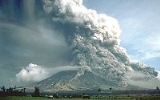
Phivolcs monitors volcano, earthquake, and tsunami activity, and issues warnings as necessary. It is mandated to mitigate disasters that may arise from such volcanic eruptions, earthquake
s, tsunami
and other related geotectonic phenomena.
Under Executive Order no. 784 of March 17, 1982, the umbrella department of COMVOL, the National Science Development Board (NSDB) was reorganized into the National Science and Technology Authority (NSTA), and COMVOL was restructured to become the Philippine Institute of Volcanology or PHILVOLC.
The seismological division of the PAGASA, the successor to the Philippine Weather Bureau created in 1907, was transferred to PHILVOLC on September 17, 1984, renaming the institute as the Philippines Institute of Volcanology and Seismology or PHILVOCS.
NSTA, the umbrella department for PHILVOCS and PAG-ASA became the Department of Science and Technology
(DOST) in 1987.
PHILVOCS was headed by Raymundo Punongbayan
from 1982 to 2003, and it is currently headed by Renato U. Solidum Jr. from 2003 to the present.
 The Philippine Institute of Volcanology and Seismology provides a classification system for the volcanoes of the country.
Philippines
The Philippines , officially known as the Republic of the Philippines , is a country in Southeast Asia in the western Pacific Ocean. To its north across the Luzon Strait lies Taiwan. West across the South China Sea sits Vietnam...
national institution dedicated to provide information on the activities of volcano
Volcano
2. Bedrock3. Conduit 4. Base5. Sill6. Dike7. Layers of ash emitted by the volcano8. Flank| 9. Layers of lava emitted by the volcano10. Throat11. Parasitic cone12. Lava flow13. Vent14. Crater15...
es, earthquake
Earthquake
An earthquake is the result of a sudden release of energy in the Earth's crust that creates seismic waves. The seismicity, seismism or seismic activity of an area refers to the frequency, type and size of earthquakes experienced over a period of time...
s and tsunami
Tsunami
A tsunami is a series of water waves caused by the displacement of a large volume of a body of water, typically an ocean or a large lake...
s, as well as other specialized information and services primarily for the protection of life and property and in support of economic, productivity and sustainable development. It is one of the service agencies of the Department of Science and Technology
Department of Science and Technology (Philippines)
The Philippines' Department of Science and Technology , abbreviated as the DOST, is the executive department of the Philippine Government responsible for the coordination of science and technology-related projects in the Philippines and to formulate policies and projects in the fields of science...
.
Phivolcs monitors volcano, earthquake, and tsunami activity, and issues warnings as necessary. It is mandated to mitigate disasters that may arise from such volcanic eruptions, earthquake
Earthquake
An earthquake is the result of a sudden release of energy in the Earth's crust that creates seismic waves. The seismicity, seismism or seismic activity of an area refers to the frequency, type and size of earthquakes experienced over a period of time...
s, tsunami
Tsunami
A tsunami is a series of water waves caused by the displacement of a large volume of a body of water, typically an ocean or a large lake...
and other related geotectonic phenomena.
History
The predecessor to PHILVOCS, the Commission on Volcanology (COMVOL) was created on June 20, 1952 by Republic Act no. 766 after the disastrous eruption of Hibok-Hibok Volcano in 1952.Under Executive Order no. 784 of March 17, 1982, the umbrella department of COMVOL, the National Science Development Board (NSDB) was reorganized into the National Science and Technology Authority (NSTA), and COMVOL was restructured to become the Philippine Institute of Volcanology or PHILVOLC.
The seismological division of the PAGASA, the successor to the Philippine Weather Bureau created in 1907, was transferred to PHILVOLC on September 17, 1984, renaming the institute as the Philippines Institute of Volcanology and Seismology or PHILVOCS.
NSTA, the umbrella department for PHILVOCS and PAG-ASA became the Department of Science and Technology
Department of Science and Technology (Philippines)
The Philippines' Department of Science and Technology , abbreviated as the DOST, is the executive department of the Philippine Government responsible for the coordination of science and technology-related projects in the Philippines and to formulate policies and projects in the fields of science...
(DOST) in 1987.
PHILVOCS was headed by Raymundo Punongbayan
Raymundo Punongbayan
Dr. Raymundo Santiago Punongbayan was the former director of the Philippine Institute of Volcanology and Seismology . SHe served from 1983 to 2002. Punongbayan became popular after handling two well-known calamities, the July 16, 1990, Luzon earthquake and the 1991 Pinatubo eruption...
from 1982 to 2003, and it is currently headed by Renato U. Solidum Jr. from 2003 to the present.
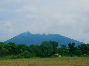
Classification of volcanoes in the Philippines
Active
- Eruption in historic times
- Historical record within 500 years
- Radiocarbon datingRadiocarbon datingRadiocarbon dating is a radiometric dating method that uses the naturally occurring radioisotope carbon-14 to estimate the age of carbon-bearing materials up to about 58,000 to 62,000 years. Raw, i.e. uncalibrated, radiocarbon ages are usually reported in radiocarbon years "Before Present" ,...
(C14) dating to 10,000 years - Local seismic activity
- Oral or folkloric history
Potentially Active
- Active solfataras, fumaroleFumaroleA fumarole is an opening in a planet's crust, often in the neighborhood of volcanoes, which emits steam and gases such as carbon dioxide, sulfur dioxide, hydrochloric acid, and hydrogen sulfide. The steam is created when superheated water turns to steam as its pressure drops when it emerges from...
s or steaming activity - Geologically young, possibly erupted < 10,000 years and for calderas and large systems, possibly < 25,000 years.
- Young-looking geomorphologyGeomorphologyGeomorphology is the scientific study of landforms and the processes that shape them...
(thin soil cover or sparse vegetation; low degree of erosion and dissection; young vent features; with or without vegetation cover). - Suspected seismic activity.
- Documented local ground deformation.
- Geochemical indicators of magmaMagmaMagma is a mixture of molten rock, volatiles and solids that is found beneath the surface of the Earth, and is expected to exist on other terrestrial planets. Besides molten rock, magma may also contain suspended crystals and dissolved gas and sometimes also gas bubbles. Magma often collects in...
tic involvement. - Geophysical proof of magma bodies.
- Strong connection with subductionSubductionIn geology, subduction is the process that takes place at convergent boundaries by which one tectonic plate moves under another tectonic plate, sinking into the Earth's mantle, as the plates converge. These 3D regions of mantle downwellings are known as "Subduction Zones"...
zones and external tectonic settings.
Inactive
- No record of eruption and its form is beginning to change by the agents of weathering and erosionErosionErosion is when materials are removed from the surface and changed into something else. It only works by hydraulic actions and transport of solids in the natural environment, and leads to the deposition of these materials elsewhere...
via formation of deep and long gullies.
Phivolcs Listings
- Philippine Institute of Volcanology and Seismology (PHIVOLCS) Active Volcano list
- Philippine Institute of Volcanology and Seismology (PHIVOLCS) Potentially Active Volcano list
- Philippine Institute of Volcanology and Seismology (PHIVOLCS) Inactive Volcano list
- Phivolcs Volcanic Classifications page
See also
- Geography of the PhilippinesGeography of the PhilippinesThe Philippines is an archipelago comprising 7,107 islands with a total land area of 300,000 km2. The 11 largest islands contain 94% of the total land area. The largest of these islands is Luzon at about 105,000 km2. The next largest island is Mindanao at about 95,000 km2...
- List of volcanoes in the Philippines
- Manila ObservatoryManila ObservatoryThe Manila Observatory is a non-profit research institute housed in the campus of the Ateneo de Manila University in Quezon City, Philippines.Founded in 1865 by the Jesuits, it has served many purposes over the years including weather...