
Petrovaradin
Encyclopedia

Agglomeration
In the study of human settlements, an urban agglomeration is an extended city or town area comprising the built-up area of a central place and any suburbs linked by continuous urban area. In France, INSEE the French Statistical Institute, translate it as "Unité urbaine" which means continuous...
of Novi Sad
Novi Sad
Novi Sad is the capital of the northern Serbian province of Vojvodina, and the administrative centre of the South Bačka District. The city is located in the southern part of Pannonian Plain on the Danube river....
in Serbia
Serbia
Serbia , officially the Republic of Serbia , is a landlocked country located at the crossroads of Central and Southeast Europe, covering the southern part of the Carpathian basin and the central part of the Balkans...
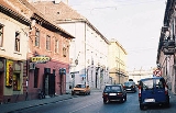
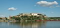
(population 13,917 in 2002). Lying across the river Danube
Danube
The Danube is a river in the Central Europe and the Europe's second longest river after the Volga. It is classified as an international waterway....
from the main part of Novi Sad, it is built around the Petrovaradin Fortress
Petrovaradin fortress
Petrovaradin Fortress is a fortress in Novi Sad, Serbia. It is located in the province of Vojvodina, on the right bank of the Danube river. The cornerstone of the present-day southern part of the fortress was laid on October 18, 1692, by Charles Eugène de Croÿ...
, known as the "Gibraltar
Gibraltar
Gibraltar is a British overseas territory located on the southern end of the Iberian Peninsula at the entrance of the Mediterranean. A peninsula with an area of , it has a northern border with Andalusia, Spain. The Rock of Gibraltar is the major landmark of the region...
of the Danube".
Name
Petrovaradin was founded as RomanRoman Empire
The Roman Empire was the post-Republican period of the ancient Roman civilization, characterised by an autocratic form of government and large territorial holdings in Europe and around the Mediterranean....
Cusum after the Romans conquered the region from the Celtic tribe of Scordisci
Scordisci
The Scordisci were an Iron Age tribe centered in the territory of present-day Serbia, at the confluence of the Savus , Dravus and Danube rivers. They were historically notable from the beginning of the third century BC until the turn of the common era...
, the Romans built the Cusum fortress where present Petrovaradin Fortress
Petrovaradin fortress
Petrovaradin Fortress is a fortress in Novi Sad, Serbia. It is located in the province of Vojvodina, on the right bank of the Danube river. The cornerstone of the present-day southern part of the fortress was laid on October 18, 1692, by Charles Eugène de Croÿ...
now stands. In addition, the town received its name from the Byzantines
Byzantine Empire
The Byzantine Empire was the Eastern Roman Empire during the periods of Late Antiquity and the Middle Ages, centred on the capital of Constantinople. Known simply as the Roman Empire or Romania to its inhabitants and neighbours, the Empire was the direct continuation of the Ancient Roman State...
, who called it Petrikòn (Πετρικον) named after Saint Peter
Saint Peter
Saint Peter or Simon Peter was an early Christian leader, who is featured prominently in the New Testament Gospels and the Acts of the Apostles. The son of John or of Jonah and from the village of Bethsaida in the province of Galilee, his brother Andrew was also an apostle...
.
In documents from 1237, the town was first mentioned under the name Petrovaradin (Pétervárad). Petrovaradin was known under the name Pétervárad under Hungarian rule, Varadin (Petervaradin) under Ottoman
Ottoman Empire
The Ottoman EmpireIt was usually referred to as the "Ottoman Empire", the "Turkish Empire", the "Ottoman Caliphate" or more commonly "Turkey" by its contemporaries...
rule, and Peterwardein under Habsburg
Habsburg
The House of Habsburg , also found as Hapsburg, and also known as House of Austria is one of the most important royal houses of Europe and is best known for being an origin of all of the formally elected Holy Roman Emperors between 1438 and 1740, as well as rulers of the Austrian Empire and...
rule.
Today, the town is known in Serbian
Serbian language
Serbian is a form of Serbo-Croatian, a South Slavic language, spoken by Serbs in Serbia, Bosnia and Herzegovina, Montenegro, Croatia and neighbouring countries....
as Петроварадин or Petrovaradin and in Hungarian
Hungarian language
Hungarian is a Uralic language, part of the Ugric group. With some 14 million speakers, it is one of the most widely spoken non-Indo-European languages in Europe....
as Pétervárad.
History
Human settlement in the territory of present-day Petrovaradin has been traced as far back as the Stone AgeStone Age
The Stone Age is a broad prehistoric period, lasting about 2.5 million years , during which humans and their predecessor species in the genus Homo, as well as the earlier partly contemporary genera Australopithecus and Paranthropus, widely used exclusively stone as their hard material in the...
(about 4500 BC). This region was conquered by Celts (in the 4th century BC) and Romans
Ancient Rome
Ancient Rome was a thriving civilization that grew on the Italian Peninsula as early as the 8th century BC. Located along the Mediterranean Sea and centered on the city of Rome, it expanded to one of the largest empires in the ancient world....
(in the 1st century BC).
The Celts founded the first fortress at this location, and during the Roman rule, a larger fortress was built (in the 1st century) with the name Cusum and was included into Roman Pannonia
Pannonia
Pannonia was an ancient province of the Roman Empire bounded north and east by the Danube, coterminous westward with Noricum and upper Italy, and southward with Dalmatia and upper Moesia....
. In the 5th century, Cusum was devastated by the invasion of the Huns
Huns
The Huns were a group of nomadic people who, appearing from east of the Volga River, migrated into Europe c. AD 370 and established the vast Hunnic Empire there. Since de Guignes linked them with the Xiongnu, who had been northern neighbours of China 300 years prior to the emergence of the Huns,...
.
The town was then conquered by Ostrogoths, Gepids, and Lombards
Lombards
The Lombards , also referred to as Longobards, were a Germanic tribe of Scandinavian origin, who from 568 to 774 ruled a Kingdom in Italy...
. By the end of the 5th century, Byzantines
Byzantine Empire
The Byzantine Empire was the Eastern Roman Empire during the periods of Late Antiquity and the Middle Ages, centred on the capital of Constantinople. Known simply as the Roman Empire or Romania to its inhabitants and neighbours, the Empire was the direct continuation of the Ancient Roman State...
had reconstructed the town and called it by the names Cusum and Petrikon. Subsequently it passed into the hands of Avars
Eurasian Avars
The Eurasian Avars or Ancient Avars were a highly organized nomadic confederacy of mixed origins. They were ruled by a khagan, who was surrounded by a tight-knit entourage of nomad warriors, an organization characteristic of Turko-Mongol groups...
, Franks
Franks
The Franks were a confederation of Germanic tribes first attested in the third century AD as living north and east of the Lower Rhine River. From the third to fifth centuries some Franks raided Roman territory while other Franks joined the Roman troops in Gaul. Only the Salian Franks formed a...
, Pannonian Croats
Pannonian Croatia
Pannonian Croatia was a medieval duchy from the 7th to the 10th century located in the Pannonian Plain approximately between the rivers Drava and Sava in today's Croatia, but at times also considerably to the south of the Sava. Its capital was Sisak...
, Pannonian Slavs, Bulgarians
Bulgarians
The Bulgarians are a South Slavic nation and ethnic group native to Bulgaria and neighbouring regions. Emigration has resulted in immigrant communities in a number of other countries.-History and ethnogenesis:...
, and by Byzantines again.
Kingdom of Hungary
The Kingdom of Hungary comprised present-day Hungary, Slovakia and Croatia , Transylvania , Carpatho Ruthenia , Vojvodina , Burgenland , and other smaller territories surrounding present-day Hungary's borders...
(in the 12th century), by the Ottoman Empire
Ottoman Empire
The Ottoman EmpireIt was usually referred to as the "Ottoman Empire", the "Turkish Empire", the "Ottoman Caliphate" or more commonly "Turkey" by its contemporaries...
(in 1526), and by the Habsburg Monarchy
Habsburg Monarchy
The Habsburg Monarchy covered the territories ruled by the junior Austrian branch of the House of Habsburg , and then by the successor House of Habsburg-Lorraine , between 1526 and 1867/1918. The Imperial capital was Vienna, except from 1583 to 1611, when it was moved to Prague...
(in 1687).
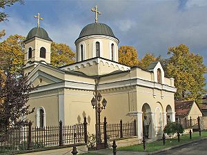
During the Ottoman rule, Petrovaradin had 200 houses, and three mosques. There was also a Christian
Christian
A Christian is a person who adheres to Christianity, an Abrahamic, monotheistic religion based on the life and teachings of Jesus of Nazareth as recorded in the Canonical gospels and the letters of the New Testament...
quarter with 35 houses populated with ethnic Serbs
Serbs
The Serbs are a South Slavic ethnic group of the Balkans and southern Central Europe. Serbs are located mainly in Serbia, Montenegro and Bosnia and Herzegovina, and form a sizable minority in Croatia, the Republic of Macedonia and Slovenia. Likewise, Serbs are an officially recognized minority in...
.
Petrovaradin was the site of a major battle on August 5, 1716
Battle of Petrovaradin
The Battle of Petrovaradin or Battle of Peterwardein was a decisive victory for Austrian forces in the war between Austria and the Ottoman Empire , at Petrovaradin, now part of Novi Sad, Vojvodina, in Serbia.-History:...
in which Prince Eugene of Savoy
Prince Eugene of Savoy
Prince Eugene of Savoy , was one of the most successful military commanders in modern European history, rising to the highest offices of state at the Imperial court in Vienna. Born in Paris to aristocratic Italian parents, Eugene grew up around the French court of King Louis XIV...
defeated the forces of the Ottomans. Eugène later defeated the Ottomans at Belgrade
Belgrade
Belgrade is the capital and largest city of Serbia. It is located at the confluence of the Sava and Danube rivers, where the Pannonian Plain meets the Balkans. According to official results of Census 2011, the city has a population of 1,639,121. It is one of the 15 largest cities in Europe...
before the Turks sued for peace at Požarevac
Požarevac
Požarevac is a city and municipality in eastern Serbia. It is the administrative center of the Braničevo District of Serbia...
.
Military Frontier
The Military Frontier was a borderland of Habsburg Austria and later the Austro-Hungarian Monarchy, which acted as the cordon sanitaire against incursions from the Ottoman Empire...
(Slavonia general command - Petrovaradin regiment). In 1848/1849, the town was part of Serbian Vojvodina
Serbian Vojvodina
The Serbian Vojvodina was a Serbian autonomous region within the Austrian Empire...
, but in 1849, it was returned under the administration of the Military Frontier. With the abolishment of the Military Frontier in 1881, the town was included into Croatia-Slavonia, the autonomous kingdom within Austria-Hungary
Austria-Hungary
Austria-Hungary , more formally known as the Kingdoms and Lands Represented in the Imperial Council and the Lands of the Holy Hungarian Crown of Saint Stephen, was a constitutional monarchic union between the crowns of the Austrian Empire and the Kingdom of Hungary in...
.
In 1918, the town became part of the Kingdom of Serbs, Croats and Slovenes. From 1918 to 1936, Yugoslav Royal Air Force
Yugoslav Royal Air Force
The Yugoslav Royal Air Force was formed in 1918 in the Kingdom of Serbs, Croats and Slovenes and existed until Yugoslavia's surrender to the Axis powers in 1941 following the Invasion of Yugoslavia during World War II....
was based in Petrovaradin. Between 1929 and 1941, the town was part of Danube Banovina
Danube Banovina
The Danube Banovina or Danube Banate was a province of the Kingdom of Yugoslavia between 1929 and 1941. This province consisted of the geographical regions of Syrmia, Bačka, Banat, Baranja, Šumadija, and Braničevo. The capital city of the Danube Banovina was Novi Sad...
, a province of the Kingdom of Yugoslavia
Kingdom of Yugoslavia
The Kingdom of Yugoslavia was a state stretching from the Western Balkans to Central Europe which existed during the often-tumultuous interwar era of 1918–1941...
. During World War 2 (1941–1944), the town was occupied by the Axis Powers and it was attached to the Independent State of Croatia
Independent State of Croatia
The Independent State of Croatia was a World War II puppet state of Nazi Germany, established on a part of Axis-occupied Yugoslavia. The NDH was founded on 10 April 1941, after the invasion of Yugoslavia by the Axis powers. All of Bosnia and Herzegovina was annexed to NDH, together with some parts...
. Since the end of the war, the town is part of the Autonomous Province of Vojvodina
Vojvodina
Vojvodina, officially called Autonomous Province of Vojvodina is an autonomous province of Serbia. Its capital and largest city is Novi Sad...
.
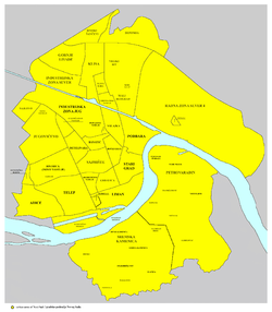
Geography
Petrovaradin is one of the two city municipalitiesMunicipalities of Serbia
Serbia is divided into 150 municipalities and 24 cities , which are the basic units of local self-government. The city may and may not be divided into city municipalities . Five cities, Belgrade, Novi Sad, Niš, Kragujevac and Požarevac comprise several city municipalities, divided into "urban" ...
of the City of Novi Sad City and it is located in the northern Serbia
Serbia
Serbia , officially the Republic of Serbia , is a landlocked country located at the crossroads of Central and Southeast Europe, covering the southern part of the Carpathian basin and the central part of the Balkans...
n province of Vojvodina
Vojvodina
Vojvodina, officially called Autonomous Province of Vojvodina is an autonomous province of Serbia. Its capital and largest city is Novi Sad...
. Approximately 25-30% of total area of City of Novi Sad
Novi Sad
Novi Sad is the capital of the northern Serbian province of Vojvodina, and the administrative centre of the South Bačka District. The city is located in the southern part of Pannonian Plain on the Danube river....
(699 km²) is an area of Petrovaradin municipality, which is approximately 100–130 km²; of which approximately 30% is a part of urban area of Novi Sad. Much of land outside of urban area is part of National Park of Fruška Gora
Fruška Gora
Fruška Gora is a mountain in north Syrmia. Most part of the territory is located within Vojvodina, Serbia, but a smaller part on its western side overlaps the territory of Croatia...
.
Petrovaradin municipality is located in the Syrmia
Syrmia
Syrmia is a fertile region of the Pannonian Plain in Europe, between the Danube and Sava rivers. It is divided between Serbia in the east and Croatia in the west....
region, on the Danube
Danube
The Danube is a river in the Central Europe and the Europe's second longest river after the Volga. It is classified as an international waterway....
river and Fruška Gora
Fruška Gora
Fruška Gora is a mountain in north Syrmia. Most part of the territory is located within Vojvodina, Serbia, but a smaller part on its western side overlaps the territory of Croatia...
, a horst mountain with elevation of 78–220 m (municipality up to 451 m). The northern part of Fruška Gora consists of massive landslide
Landslide
A landslide or landslip is a geological phenomenon which includes a wide range of ground movement, such as rockfalls, deep failure of slopes and shallow debris flows, which can occur in offshore, coastal and onshore environments...
zones, but they are not active, except in Ribnjak
Ribnjak
Ribnjak is a small neighborhood of Novi Sad, situated in the Serbian province of Vojvodina.-Name:Its name is derived from the Serbian word "riba"...
neighborhood (between Sremska Kamenica
Sremska Kamenica
Sremska Kamenica is a town and urban neighborhood of Novi Sad, in Serbia.-Name:In Serbian, the town is known as Sremska Kamenica , in Croatian as Srijemska Kamenica, in Hungarian as Kamanc, and in German as Kamenitz.-Geography:The town is located in the Syrmia region, on the northern slopes of the...
and Petrovaradin fortress
Petrovaradin fortress
Petrovaradin Fortress is a fortress in Novi Sad, Serbia. It is located in the province of Vojvodina, on the right bank of the Danube river. The cornerstone of the present-day southern part of the fortress was laid on October 18, 1692, by Charles Eugène de Croÿ...
).
Politics
The town of Petrovaradin is the seat of Petrovaradin municipality. Since 2002, when the new statute of the City of Novi Sad came into effect, it has been divided into two urban municipalities, Petrovaradin and Novi SadNovi Sad municipality
City Municipality of Novi Sad is one of two city municipalities which comprise the City of Novi Sad in Serbia. The population of the municipality include approximately 335,000 people.-Politics:...
. Between 1980 and 1989, Petrovaradin also had municipality status within Novi Sad. From 1989 to 2002, Novi Sad's municipalities were abolished and territory of the former Petrovaradin municipality was part of Novi Sad municipality, which included the whole territory of the present-day City of Novi Sad.
City municipalities of Novi Sad were formally established in 2002, for the sole reason that Novi Sad could get a city status. In 2007, after the update of the law of local government, the requirement for multiple municipalities for city status was lifted (and 20 additional cities were proclaimed). However, the renewed 2008 city statute also foresaw formation of two separate municipalities, but as of 2009 none of them exist, and the city is ran only by the city administration. Today, Petrovaradin municipality does not have its own offices.
Settlements and neighborhoods
- town of Petrovaradin
- town of Sremska KamenicaSremska KamenicaSremska Kamenica is a town and urban neighborhood of Novi Sad, in Serbia.-Name:In Serbian, the town is known as Sremska Kamenica , in Croatian as Srijemska Kamenica, in Hungarian as Kamanc, and in German as Kamenitz.-Geography:The town is located in the Syrmia region, on the northern slopes of the...
- village of BukovacBukovacBukovac is a village in Serbia. It is situated in the Petrovaradin urban municipality , in the Vojvodina province. The village has a Serb ethnic majority and its population is 3,595 .-The name:The name Bukovac is thought to be derived from the word for a tree - 'bukva'...
- village of LedinciLedinciLedinci , also known as Novi Ledinci , is a village located in the Petrovaradin municipality, one of two municipalities of Novi Sad City, in Serbia. It is situated in the Autonomous Province of Vojvodina...
- village of Stari LedinciStari LedinciStari Ledinci , also known simply as Ledinci , is a village located in the Petrovaradin municipality, one of two municipalities of Novi Sad City in Serbia, in the Autonomous Province of Vojvodina. The population of Stari Ledinci numbered 823 people in the 2002 census...
Neighborhoods and parts of the Petrovaradin town are: Petrovaradin Fortress
Petrovaradin fortress
Petrovaradin Fortress is a fortress in Novi Sad, Serbia. It is located in the province of Vojvodina, on the right bank of the Danube river. The cornerstone of the present-day southern part of the fortress was laid on October 18, 1692, by Charles Eugène de Croÿ...
, Podgrađe Tvrđave (which is a fortified part of Petrovaradin and part of Petrovaradin Fortress
Petrovaradin fortress
Petrovaradin Fortress is a fortress in Novi Sad, Serbia. It is located in the province of Vojvodina, on the right bank of the Danube river. The cornerstone of the present-day southern part of the fortress was laid on October 18, 1692, by Charles Eugène de Croÿ...
complex), Stari Majur (which is part of Petrovaradin where offices of Petrovaradin municipality and local community are located), Novi Majur, Bukovački Plato (Bukovački Put), Sadovi, Široka Dolina, Širine
Širine
Širine is a settlement in the region of Baranja, Croatia. Administratively, it is located in the Petlovac municipality within the Osijek-Baranja County. Population is 86 people.-See also:*Osijek-Baranja county*Baranja...
, Vezirac, Trandžament, Ribnjak
Ribnjak
Ribnjak is a small neighborhood of Novi Sad, situated in the Serbian province of Vojvodina.-Name:Its name is derived from the Serbian word "riba"...
, Mišeluk
Mišeluk
Mišeluk is a neighborhood of the city of Novi Sad in Serbia.-Geography:Mišeluk is located in Syrmian part of Novi Sad, between Petrovaradin and Sremska Kamenica. Administratively, Mišeluk is regarded as part of Petrovaradin...
, Alibegovac, Radna Zona Istok, Marija Snežna (Radna Zona Istok), and Petrovaradinska Ada (Ribarska Ada).
Ethnic groups in the municipality
According to the 2002 censusCensus
A census is the procedure of systematically acquiring and recording information about the members of a given population. It is a regularly occurring and official count of a particular population. The term is used mostly in connection with national population and housing censuses; other common...
, the total population of the territory of present-day Petrovaradin municipality was 31,227, of whom 24,026 (76.94%) were ethnic Serbs
Serbs
The Serbs are a South Slavic ethnic group of the Balkans and southern Central Europe. Serbs are located mainly in Serbia, Montenegro and Bosnia and Herzegovina, and form a sizable minority in Croatia, the Republic of Macedonia and Slovenia. Likewise, Serbs are an officially recognized minority in...
. All settlements in the municipality have an ethnic Serb majority.
Ethnic groups in the town
| Ethnic group | 1991 | % | 2002 | % |
| Serbs Serbs The Serbs are a South Slavic ethnic group of the Balkans and southern Central Europe. Serbs are located mainly in Serbia, Montenegro and Bosnia and Herzegovina, and form a sizable minority in Croatia, the Republic of Macedonia and Slovenia. Likewise, Serbs are an officially recognized minority in... |
5,643 | 50% | 9,708 | 69.47% |
| Croats Croats Croats are a South Slavic ethnic group mostly living in Croatia, Bosnia and Herzegovina and nearby countries. There are around 4 million Croats living inside Croatia and up to 4.5 million throughout the rest of the world. Responding to political, social and economic pressure, many Croats have... |
2,196 | 19.45% | 1,364 | 9.76% |
| Yugoslavs Yugoslavs Yugoslavs is a national designation used by a minority of South Slavs across the countries of the former Yugoslavia and in the diaspora... |
1,893 | 16.77% | 779 | 5.58% |
| Hungarians | 431 | 3.82% | 396 | 2.83% |
| Montenegrins | 250 | 2.22% | 228 | 1.63% |
| Ukrainians Ukrainians Ukrainians are an East Slavic ethnic group native to Ukraine, which is the sixth-largest nation in Europe. The Constitution of Ukraine applies the term 'Ukrainians' to all its citizens... |
219 | 1.94% | n/a | - |
| Ruthenians Pannonian Rusyns Rusyns in Pannonia, or simply Rusyns or Ruthenians , are a Slavic minority in Serbia and Croatia... |
n/a | - | 141 | 1.01% |
| Other | 653 | 5.79% | 1,357 | 9.71% |
| Total | 11,285 | - | 13,973 | - |
During the Ottoman rule, Petrovaradin was mostly populated by Muslims, while some Serbs lived there as well in the Christian quarter. During the Habsburg rule and in the first half of the 20th century, the largest ethnic group in the Petrovaradin town were ethnic Croats
Croats
Croats are a South Slavic ethnic group mostly living in Croatia, Bosnia and Herzegovina and nearby countries. There are around 4 million Croats living inside Croatia and up to 4.5 million throughout the rest of the world. Responding to political, social and economic pressure, many Croats have...
. Today, there are a couple of Croat-inhabited neighborhoods in Petrovaradin, like Stari Majur and Podgrađe Tvrđave.
Historical population of the town
In 1961 Petrovaradin had 8,408 inhabitants; in 1971 10,477; in 1981 10,338; in 1991 11,285; and in 2002 13,973. By city's registry estimation, from mid-2005, Petrovaradin town had 15,266 inhabitants.Culture
EXITEXIT (festival)
Exit is an annual summer music festival in the Petrovaradin Fortress of Novi Sad, Serbia. It is staged annually since 2000 and usually lasts four days ....
(also known as State of EXIT) is an annual summer music festival in Petrovaradin fortress. It is staged annually since 2000 and usually lasts for 4 days.