

Petitcodiac River
Encyclopedia
The Petitcodiac River is a Canadian
river in south-eastern New Brunswick
. The river runs about 79 kilometres (49.1 mi) through the province's Westmorland
, Albert
, and Kings
counties, draining a watershed area
of about 2071 square kilometres (799.6 sq mi). The region around the river features valleys, ridges, and rolling hills, and is home to a diverse population of terrestrial and aquatic species. Ten named tributaries
join the river in its course toward its mouth in Shepody Bay
. Before the construction of a causeway
in 1968, the river had one of the world's largest tidal bore
s, which ranged from 1 to 2 m (3.3 to 6.6 ft) in height and moved at 5 to 13 km/h (3.1 to 8.1 mph).
The Mi'kmaq were the first to settle near the river, and used it as part of a portage route between Shubenacadie
and the village of Petitcodiac
, where they had a winter camp. Acadians from Port Royal, Nova Scotia
colonised the region in 1698, but were expelled in 1755 during the French and Indian War
. Acadian resistance fighters in Village-des-Blanchard (now Hillsborough
) fought under the command of French leader Charles Deschamps de Boishébert in the Battle of Petitcodiac
to fend off British troops and suffered the destruction of most of their settlement. In the 1840s, the Greater Moncton
area saw a shipbuilding boom, but this was halted following the arrival of the steam train, and forced the town to unincorporate. These changes eventually marginalised the Petitcodiac River.
In 1968, a controversial rock-and-earth fill causeway was built between Moncton and Riverview
to prevent agricultural flooding and to carry a crossing between the two communities. The causeway caused many problems for the river and its surrounding ecosystem. An estimated of silt was deposited in the 4.7 km (2.9 mi) of river downstream from the causeway in the first three years following construction. The causeway restricted the movement of fish and reduced the region's salmon catches by 82 percent. Water quality has also dropped thanks to industrial expansion around the area. In 2003, Earthwild International designated the Petitcodiac River as the most endangered river in Canada because of these problems. On April 14, 2010, the causeway's gates were opened permanently as part of a $68 million three-phase project designed to restore the river, to be completed by 2015.
term Epetkutogoyek, meaning "the river that bends like a bow", a reference to the right angle bend near Moncton. Acadians transformed this to Petcoudiac or Petitcoudiac, which was modified to Petitcodiac by British settlers. The river's heavy sedimentation led to the nickname "Chocolate River", due to the resulting brown tint. When the Petitcodiac River Causeway was built, an additional of this sediment began to accumulate in the 4.7 km (2.9 mi) of river downstream from it.
of the Anagance and North rivers in western Westmorland County
. The Anagance River arises from its tributaries, Hayward Brook and Holmes Brook, and drains 81 km² (31.3 sq mi) from the south-east of the Petitcodiac River, while the North River drains 264 km² (101.9 sq mi) from the north. From the confluence, the river passes under the bridge on Route 106
in Petitcodiac, The road then follows the river to Moncton on the left side of the river. Route 1
crosses the river a few kilometres downstream to join Trans-Canada Highway 2
. The community of River Glade precedes Petitcodiac River's right tributary, Pollett River, with a watershed of 314 km² (121.2 sq mi). As the waterway runs past Salisbury, its final major right tributary, Little River (formerly known as Coverdale River), joins it. Little River's watershed is 275 km² (106.2 sq mi). The river passes Coverdale and is joined by Turtle Creek before widening as it approaches Moncton.
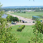
The causeway, built in 1968, formed a wall blocking all but 100 m (328.1 ft) of water as the river flowed downstream toward the Gunningsville Bridge
. Before the causeway's construction, the river's area would expand through Moncton, attaining a width of 1.6 km (one mile). A series of banks to both sides precede the 90 degree turn to the south, a feature that gave Moncton its original name, Le Coude (The Elbow). The river passes Dieppe on its eastern side and Hillsborough on its western side before it approaches its mouth.
The Memramcook River, which has a watershed area of 412 km² (159.1 sq mi) joins the Petitcodiac River near its mouth. The Petitcodiac River then widens and drains into Shepody Bay, where there is a 122 km² (47.1 sq mi) wetland. Once past the Hopewell Rocks
, Shepody Bay merges with the Cumberland Basin, which runs south-west toward Chignecto Bay
. Chignecto Bay drains into the Bay of Fundy, which flows into the Gulf of Maine
, which proceeds south-east into the Atlantic Ocean
through the Northeast Channel.
to the south. Although the Petitcodiac River's watershed is geographically distinct from that of the nearby Memramcook River, some groups merge the two for categorisational purposes.
The area has been occupied by Europeans since the late 17th century. Moncton's population has grown rapidly since the 19th century, rising from fewer than 100 people in 1825, to over 15,000 people in 1917, and to 126,000 people in 2006. In spite of this growth, most of the area remains relatively undisturbed: 80 percent of the watershed is covered with forest, a tenth is used for agriculture and three percent is occupied by wetland
s. Only four percent of the area is used for commercial, residential, or private usage. Nevertheless, the Petitcodiac Watershed Monitoring Group noted in 2001 that this growth is one of the main factors for the ongoing "environmental degradation" of the river.
's Rupert River
, in 2002. The causeway was cited as one of the major factors behind the river's degraded health. The Canadian Council of Ministers of the Environment
's Water Quality Index gave two study sites an "excellent" rating, 20 sites a "good" rating, 27 sites a "fair" rating, and five sites a "marginal" rating.
Since 1999, the Petitcodiac Watershed Alliance (known as the Petitcodiac Watershed Monitoring Group at the time) has collected water samples from May to October to study bacteria, nutrient, pH
, dissolved oxygen
(DO), and sediment levels. Two sampling sites, one upstream from the causeway and one downstream, were used during the 2009 study. The river had an average temperature of 27 °C (80.6 °F) in August at the upstream location, in contrast to the average of 20.1 °C (68.2 °F) at the same site over the total period of the study. E. coli
levels were high upstream, and above recreationally safe levels downstream in June, July, and August. Nitrate
s and phosphate
s failed to meet the safe quality threshold on occasion. A publication by the New Brunswick Department of Environment in 2007 showed that the watershed did not meet the quality guidelines for E. coli in 10 percent of samples, for dissolved oxygen in 5 percent of samples, and pH in 3 percent of samples; in contrast, the river was always within safe nitrate levels.
During their 2001 study, the Petitcodiac Watershed Alliance noted the effects of agriculture on the river's water quality, and recommended to work with local farmers to install cattle fencing
around streams which run through their properties, and "eventually phase out" cosmetic pesticide usage. The Petitcodiac Riverkeeper holds a stronger position on the issue: the organisation notes that pesticides "find their way into the surface and ground water by leaching into the soil or as part of stormwater runoff." They request that, while measures have been taken in 2009 by the provincial government to regulate cosmetic pesticide usage, the province must forbid its usage altogether and require chemical manufacturers to disclose health warnings and all ingredients on labels. The New Brunswick Department of Environment also warned of the erosion caused by the removal of the river's riparian zone
s, which is a common "land use practice".
Although mining around the area essentially stopped with the closure of the gypsum mines in 1982, uranium mining has surfaced as a potential problem for the river. The province was the subject of a controversy in 2007 when it gave Vale Limited (formerly known as CVRD Inco) the right to mine for uranium at Turtle Creek
, where the Greater Moncton water reservoir is maintained. Environmentalists warned of the dangers related to the move, fearing that contaminants could be pushed into the surrounding water. The Petitcodiac Riverkeeper also noted uranium mining's "irreversible effects to the health of ecosystems, watersheds, wildlife, agriculture, recreation, and public health", and joined 30 other environmental groups in asking the provincial government to establish a ban on the act. The province would later restrict uranium mining to 300 m (984.3 ft) from residential areas and ban it from protected drinking water areas. Another controversy in 2006 involved exploration for oil and gas deposits in the same area, but access was blocked by the municipal government.
Shortly after the building of the causeway, a 35 ha (86.5 acre) landfill was built near the river. Various materials were disposed of in the area, including petroleum waste oil, pipe and foam insulation, sewage sludge, and medical waste. While the landfill was shut down in 1992, samples by the Environmental Bureau of Investigation and the Petitcodiac Riverkeeper showed that ammonium levels around the leachate
exceeded Canadian quality guidelines by as much as 15 times, and contained heavy metals, petroleum hydrocarbons, and PCBs. A mortality rate of 100 percent was found for test trout and daphnia
when exposed to water samples. Gemtec Limited, the company responsible for planning and closing the landfill, and the City of Moncton were charged on March 12, 2002, for offences relating to the Canadian Environmental Protection Act (1999) and the Fisheries Act. The city pleaded guilty on September 23, 2003, paid a $35,000 fine, and was ordered to help reduce the leachate flow from the landfill. Three years later, Gemtec Limited was fined a total of $6,000 and was ordered to contribute a total of $22,000 to the federal Environmental Damages Fund and the Jonathan Creek Committee.
of 27.3 m3/s into its mouth yearly, with a recorded high of 730 m3/s in 1962 and a low of 0.36 m3/s in 1966. The same report estimated mean values for the minimum and maximum discharges for every two-year, 10-year, and 100-year flood
events, and minimum discharges for every two-year, five-year, and 100-year "drought" events:
referred to the tidal bore in a hydrographic chart published in 1861, observing that "[after] its passage the rise of the tide is very rapid until high water is attained", and that "[during the lowest tides] the Bore still appears but its broken front usually is only a few inches high."
The bores ranged from 1 to 2 m (3.3 to 6.6 ft) in height, with speeds from 5 to 13 km/h (3.1 to 8.1 mph). In 1825, Peter Fisher noted that the "noise of the Bore is heard a great distance, and animals immediately take to the highland, and manifest visible signs of terror if near it." Before the causeway (1968), values were compared with the tidal bores of the Qiantang
, Hooghly and Amazon
rivers. After the causeway was built, the bores reached heights from about 5 to 75 cm (2 to 29.5 in).
species included the brook floater, the dwarf wedgemussel
, the Eastern ellipto, the Eastern floater, the Eastern pearlshell, and the triangle floater. Many other aquatic organisms are thought to have once entered the watershed due to the low salinity of the water.
Six species have disappeared from the river since the mid-1980s. The Petitcodiac River was the only known Canadian habitat of the dwarf wedgemussel, and was later isolated to just nine American
watersheds after its elimination from the Petitcodiac. The Atlantic salmon is no longer present in the watershed, and has since been listed as an endangered species
in Canada. The American shad was a favourite with fishermen, and represented two-thirds of the entire Canadian shad landings from 1870 to 1900; catches peaked at 2 to 6 lb (0.90718474 to 2.7 kg) million kilograms (two to six million pounds) per year. Three other species have been eliminated from the river: the striped bass, the Atlantic sturgeon, and the Atlantic tomcod. However, a project of the Petitcodiac Riverkeeper, funded by the Government of Canada's Environmental Damage Fund in 2005, noted that the removal of the causeway would result in a "good" chance of bringing back the eliminated species, and an "excellent" chance of increasing the numbers of species deemed to have been reduced in numbers. No data has been released for the Atlantic salmon or the striped bass.
Various insects and arachnids reside around the Petitcodiac River. Among them is the stonefly, the mayfly, the caddisfly, the simulium
, the subfamily of tanypodinae
, and the Hydracarina. Non-native species, such as the black-footed spider, the beech scale, the white-marked tussock moth, and the mountain ash sawfly have also made their home in the Petitcodiac River watershed. At the southern extremities of the watershed, 50 to 90 percent of the world's Semipalmated Sandpiper
s feed on the mud shrimp at Shepody Bay. Around 269,445 stop there before migrating to South America, a number which accounts for at least 7.7 percent of the total population. Among others, the Semipalmated Plover (around 2 percent of the North American population), the Short-billed Dowitcher, the Red Knot, the Sanderling, and the Least Sandpiper are also known for migrating through the Important Bird Area
(IBA).
A diverse number of plant species reside in the watershed as well. Red, white, and black spruce, red maple, white birch, and trembling aspen are the most common. Jack pine is commonly found in regions that fires have repeatedly ravished, while cedar is found in bogs and areas where gypsum and limestone are present. Higher altitude slopes and ridgetops house sugar maple, beech, and yellow birch trees. Zelazny et al. note that "[the] high frequency of disturbed sites dominated by aspen stands reveals the degree of historical and recent human disturbance along the Petitcodiac River." The Petitcodiac River's riparian zone
houses a number of trees, including willows, white spruce, white pine, and speckled alder. Other trees, such as the tamarack and white pine, can also be found in the watershed. Plants such as the rufous bulrush
tend to grow near calcareous areas, and hemlock
can be found in small, pure stands. Alien plant species include the Mother-of-Thyme, the Japanese barberry, the Scotch Broom, the yellow flag, and Canada bluegrass.
In 1937, the 37,000 year-old skeleton of a mastodon
was discovered by workers near Hillsborough
. It was in near perfect condition and was transported to the New Brunswick Museum
in Saint John
, where it has been displayed ever since.
period. Non-calcareous
Pennsylvanian
(and younger) sandstones, conglomerate
s, silt, and red- to grey-tinted mudstone
now compose the majority of the bedrock. The northern shore of the Petitcodiac River, including the Anagance and North rivers, is primarily made up of shale with volcanic rocks, mixed igneous rocks, and felsic
pebble conglomerates. The southern shore, including the Little and Pollett rivers, is composed of Precambrian
or Lower-Palaeozoic sedimentary, igneous, and volcanic rocks, and limestone. Both shores include red to grey Mississippian sandstone. Red beds
, or red-tinted sedimentary rocks, have a higher occurrence around Port Elgin
. Other significant Mississippian-era rock patches appear in two areas around the watershed. The first is located near the north-western border of the watershed, near Lutes Mountain and Cornhill. The second ranges from the east of the Memramcook River to the west of Hillsborough, in Beech Hill. The Petitcodiac River watershed also features karst topography
, where gypsum
and limestone around Mississippian rocks dilute into the circulating groundwater. This creates sinkhole
s, depressions
, and caves. Examples of rare karst occurrences appear west of the village of Petitcodiac, where large sinkholes alternate between small ridges to form honeycomb-shaped patterns. Hillsborough is the home of one of the longest gypsum cave networks in eastern Canada, and is a key habitat for bats in hibernation.
The majority of the watershed's topsoil
is composed of sand, clay, and silt, under which normally lies a layer of ablation moraine
s. Fairly rich soils made of alluvium
and tidal deposits are found along the Petitcodiac and Memramcook rivers, and have often been exploited for agricultural purposes. A publication by the New Brunswick Department of Natural Resources notes that the soils in Salisbury, made from calcareous sandstone and mudstone, are fine-textured and, when properly drained, "are the most fertile glacial tills" in the watershed. In contrast, they note, soils deriving from local conglomerates are more coarse and sandy, and are less fertile.
Albertite
, a type of asphalt, was first found in Albert County in 1849 by the Canadian physicist Abraham Gesner, inventor of kerosene
. Over 200,000 tonne
s of the mineral were shipped to Boston
within 30 years. Large deposits of gypsum found eight kilometres (five miles) from the mining site were shipped around the globe as well. The Petitcodiac River was used as the primary means for transporting the minerals at the time.
(now Nova Scotia
and New Brunswick), led by the explorer Pierre Dugua de Mons and accompanied by cartographer Samuel de Champlain
and future Acadian governor Jean de Biencourt
, sailed into the Bay of Fundy. Hoping to find an ideal site for a settlement, they passed Advocate Harbour
and the Saint John River before Dugua chose to settle on Saint Croix Island in present-day Maine
. Although they did not explore the Petitcodiac region, they returned to the coasts of eastern Nova Scotia, where they founded Port Royal
. In 1676, Jacques Bourgeois, a colonist from the Nova Scotian settlement, settled in the area of Beaubassin
(now the Tantramar Marshes
). By 1685, its population had grown to 129, with 19 out of the 22 families living permanently in the region. Pierre Thibodeau, also from Port Royal, founded Chipody (now Shepody, New Brunswick
) near Shepody Bay in 1698. At this time, the inhabitants often referred to the Petitcodiac, Memramcook, and Shepody River area as "Trois-Rivières" (Three Rivers) (not to be confused with Trois-Rivières, Quebec
).
erupted in 1754 amid tensions between the British and the French over control of the Ohio Valley. Initially, the inhabitants of Acadia were uninvolved in the conflict because the French had already ceded the land to Britain under the Treaty of Utrecht
(1713). The Acadians were asked to take an oath declaring complete fidelity toward the British Monarch on several occasions, but they refused. At first, they were not punished for doing so. A declaration of neutrality was signed in 1730 and was accepted by Nova Scotia governor Richard Philipps
. This earned the Acadians the nickname the "neutral French". At the outbreak of war in 1754, the British again demanded unconditional oaths of fealty, perceiving the Acadians as a possible threat. In spite of resistance led by Jean-Louis Le Loutre
, representatives eventually agreed to sign, but their reluctance persuaded Governor Charles Lawrence to order the Acadian population expelled from British territory.
About 1,100 Acadians living around the Petitcodiac River were affected by this decision. Two hundred British troops led by Major Joseph Frye were sent to destroy the settlements of the Three Rivers, beginning with Shepody and Village-des-Blanchard (now Hillsborough). French resistance commander Charles Deschamps de Boishébert
, hoping to evacuate as many Acadians as possible, was unable to march the distance between Nerepis
and the Shepody settlement in time, but fought at the second threatened village
on August 28, 1755. Boishébert's troops, composed of inhabitants from the area and from Shepody, counter-attacked, suffering only one loss to twenty-three British casualties. This defeat is thought to have been the reason for the British abandonment of the campaign at the Three Rivers. The commander and the evacuated Acadians, whom Edward Larracey estimated to total around 700, suffered a massive famine from 1756 to 1758, largely caused by the scarce resources following the battle.
In 1758, Joseph Broussard
, also known as Beausoleil by the locals, led raids against British vessels sailing in the Bay of Fundy and the Cumberland Basin. This provoked the British into initiating two raids of their own. The first took place in February in Shediac
, where Lieutenant Colonel George Scott tried to find Boishébert. When they were returning, Boishébert ambushed them, killing two of Scott's gunmen. The second raid took place at the settlement of Shepody in March, where the British were shocked to find that the Acadians had already begun rebuilding their homes. On June 28, Scott learned of reports that cattle were stolen outside of Fort Beausejour; the British issued an order for Captain Beloni Danks
to send 75 men up the Petitcodiac River
. They arrived in Moncton the following night, and about 30 Acadians began firing at their vessel. However, Danks held his offensive position, and the British killed 19 Acadians, taking nine others prisoner. He and his troops continued to sail up the river the next day; they sent 60 men to burn a settlement 6 mi (9.7 km) west of Moncton. Historians presume that the area had already been deserted.
Acadians continued to survive in the region, overcoming the results of the raids. Scott sailed back to the region to search for Beausoleil and to weaken the Acadians before the winter. He arrived in Moncton near midnight on November 12, but the tide of the Petitcodiac River prevented him from sending more than twelve men. They came back the next morning with 16 prisoners. Scott was told that the area was virtually defenceless, so he sent three parties to La Chapelle (now Bore Park in Moncton), Silvabro (now Lewisville), and Jagersome (now Dieppe). Scott recorded no deaths or prisoners, but all buildings in sight were burned, and cattle were brought back onto the vessel. Additional raids by Scott between November 14 and November 17 captured a dozen Acadian prisoners, burned settlements, and uncovered Beausoleil's own schooner
. The crew sent an Acadian prisoner on the 17th to request the surrender of the remaining residents, but when he returned, he reported that they had all begun to flee to Cocagne
, Shediac, and the settlements around the Miramichi River
. This prompted Scott to return to Fort Frederick in Saint John.
A few of the Acadians migrating to the Miramichi River probably died of hypothermia
during the trip due to the 1758–59 winter. Those who survived joined the refugees already present, who had been persuaded by Boishébert to seek refuge there. Inadequate housing and supplies, among other reasons, led to the deterioration of the reputation of the French commander, and only 700 Acadians remained there by late 1759. Meanwhile, the raiding rapidly took its toll on the residents who stayed around the Three Rivers, as food supplies became scarce and reconstruction became impossible. The fall of Quebec City
in September of 1759 also eliminated the possibility of assistance from that area. On November 16, 1759, the 190 Acadians in the region sent a delegate to Fort Beauséjour (which had been renamed Fort Cumberland) to announce their surrender to the newly-promoted Colonel Frye. The settlements of Miramichi
, Richibucto
, and Bouctouche
surrendered the next day, with a delegate sent to the fort to represent their 700 refugees. Frye requested and received permission from Governor Lawrence to take them in for the winter. The Acadian refugees were offered land on the Isthmus of Chignecto
in early 1760, but most requested their original lands around the Three Rivers, which the governor granted.
(1763), exiled Acadians began to return to the area, but their numbers around the Three Rivers remained under 200 by 1769. Settlers from Philadelphia began to migrate to the Petitcodiac River area in 1766: the Trites, Jones and Stieff families moved to present-day Moncton, but the Stieff family (now Steeves), later moved south-east to Hillsborough. Nine families bought land up to 13 mi (20.9 km) west from the bend of the river, ranging from 1718 to 2193 acre (695.3 to 887.5 ha) per grant. In 1829, the population of Moncton reached 100, composed mainly of descendants of these settlers.
Moncton's shipbuilding
era began in 1840 with the arrival of Stewart Russell, a shipbuilder from Hopewell. Russell built the Aginora, which sailed down the Petitcodiac River to trade at the ports in Saint John and New England
. The ship and its crew sank in a storm on December 24, 1850, during a trip to Boston for Christmas. A ferry service on the Petitcodiac River was launched around 1841, thanks to a license obtained by Simon Outhouse. The Larch, built by Stephen Binney
in 1845, was another important vessel, becoming the largest to sail on the river. But it was not until the arrival of Joseph Salter in 1846 that the shipbuilding boom began: a shipyard founded by Binney and Salter produced 24 vessels from 1847 to 1859, and employed almost 500 of the 1,000 inhabitants in Moncton. Salter would become the first mayor of Moncton in April 1855, the year the town was incorporated.
The European and North American Railway
was extended to link Pointe-du-Chene
to Moncton in 1857, with an eventual goal of reaching Saint John in 1860. The move, according to Larracey, caused the town to become "but a station stop along a railway line". This coincided with the failure of Moncton's shipbuilding industry and a population drop from a peak of 2,000 to about 500. The town declared bankruptcy and was unincorporated in 1862, but it later regained its status in 1875, after it became the Intercolonial Railway's headquarters for its shops in 1871. While the Petitcodiac River continued to aid in the shipping of goods into the 20th century, shipbuilding essentially ended in the 1890s. The final vessel built in Moncton was the Woolastook II on May 14, 1980, while the final ship to sail up the Petitcodiac River was the Inox from France, which arrived on July 12, 1986, (and was, ironically, stranded in Moncton until November 3 due to the river's tidal fluctuations).
In 1924, the Petitcodiac Tidal Power Company proposed a tidal power
project. This called for a dam to be built between Hopewell Cape
and Fort Folly Point. The company sold shares to raise funds for the project and a series of on-site and airborne studies were conducted by the federal government, but the project fell through by 1928. As rail transport became more common, it displaced river transportation around the Great Depression
. In addition, the Greater Moncton International Airport
offered an airmail service
from Moncton to Montreal
by December 29, 1929. These factors further marginalised the Petitcodiac.
The Gunningsville Bridge
, which crosses the Petitcodiac River to link Moncton and Riverview, was built in 1867. It was damaged and rebuilt on four different occasions. The first was following the Saxby Gale of 1869
, which forced the town to rebuild the bridge in 1872. It went under "extensive repairs" mid-1892, but ice build-up from the Petitcodiac continued to pose a threat for the wooden structure, leading to the construction of a new steel version from 1915 to 1919. This fourth bridge would suffer through many collisions, including one with the Mayflower in September 1929, which caused the ship to capsize and drown two men. The Gunningsville Bridge would last 86 years before it would be demolished a final time, making way for a 425 metres (1,394.4 ft) four-lane bridge crossing. Covered bridges were also built over the Petitcodiac River, the final extant one being "Hasty", built in 1929.
It was not until 1978 that New Brunswick's Department of Transportation commissioned a study of the problems. The final report recommended three alternatives for action: to continue operation "as-is", to continue operation without the gates, or to eliminate gate leakage and amend the operation protocol. The third alternative was chosen two years later, but did not substantially improve fish migration as expected. The provincial government decided to open the gates between April 15 and July 7, 1988, to allow fish to migrate up the stream. This was repeated from September 26 to October 31, 1988, and in the spring of 1989 and 1990 during low tides. In 1991, New Brunswick's Department of Oceans and Fisheries recommended opening the gates from April to December each year. A provincial government committee report recommended an additional seven options for the modification of the causeway in May 1992, but the government did not act upon any of these options due to the low "cost-benefit" factor. More reports documented problems related to the passage of fish in the river until 1995, when the Department of Transportation agreed to open one gate from April to December, as suggested four years earlier. A project was then organized in December 1996 to begin a trial for the systematic opening of the gates during the year, but conditions could not be physically met, and it was terminated on June 1, 1999.
In February 2001, the Niles Report proposed an additional four modifications to the causeway project: to either replace the fishway, open the gates during peak fish migration, open the gates permanently, or replace the entire causeway with a bridge. An Environmental Impact Assessment study was commissioned in 2003 to develop and summarise these options, and on its completion in 2005, it announced the recognition of "Option 3" and "Option 4" as possible solutions. The first option had been ruled out following the evaluation of other fish passage models, which were deemed inapplicable to the river. The second, suggesting systematic gate-opening periods, was ruled out because of the inability to cater to every marine species' migration periods. Option 4 was split into three sub-options, mainly to list possible bridge lengths: 170, 280, and 315 metres (190, 310, and 344 yards). The provincial government later accepted the proposal on December 6, 2006, and selected "Option 4B" on August 7, 2007, which called for a 280 m (306.2 yd) bridge in the place of the causeway.
The project was divided into three phases, expected to cost a total of $68 million. Phase 1 consisted of the prevention of erosion along the shorelines, improvements to the nearby drainage system, and the construction of dikes and aboiteaux; the work was carried out from July 7, 2008, to April 14, 2010. Phase 2 consists of opening the gates to monitor river flow, both upstream and downstream, for two years. Phase 3, set to commence in 2012, will consist of the bridge's development and the removal of the causeway, and is anticipated to be completed in 2015. Confusion arose as to whether or not the project would be funded by the federal government. They refused, in spite of an earlier comment from the Department of Fisheries and Oceans, which had hinted at a possible negotiation. Unwilling to wait, the provincial government came forward with an initial $20 million on July 7, 2008, to begin the first phase.
The approach of Phase 2 was met with various complaints. A biology professor at the Université de Moncton
noted that $200,000–$250,000 worth of pesticide would be required to keep the mosquito population around the city of Moncton from doubling once the gates open. Flood warnings were issued by the provincial Department of Supply and Services for the town of Riverview, warning that high river tides could lead to the flooding of over 3 hectares (7.4 acre) of sport fields and structures built in low-lying areas; however, they added that the causeway's flood gates were able to descend if required, eliminating the chances of such repercussions from a possible inundation. Residents near the headpond west of the causeway criticized the project, citing the decrease in property values of about 480 homes (by approximately 30 percent, according to the EIA report), the $68 million price tag, unstable ice conditions, and a lower water quality. In spite of legal threats by the Lake Petitcodiac Preservation Association (LAPPA) and various residents, the causeway opened its gates on April 14, 2010, coinciding with the beginning of various studies.
Since the opening, the river improved significantly, surpassing original expectations for the project. An AMEC
engineer participating in the firm's studies, Jacques Paynter, said that the banks of the river had began widening "at a noticeable pace", with the tidal bore growing closer to its pre-1968 levels: "We were actually anticipating a fairly modest increase in height. It seems to be already exceeding what we might have expected." He noted that an estimated 40,000 gaspereau had returned to the river, and called for more studies to determine the impact of the causeway's opening.
as major pre-causeway activities. A fishery for Atlantic salmon existed downstream from the causeway for several years post-1968. The Moncton Naturalists' Club also publishes their Birding in the Moncton Area, a birdwatching guide covering sites from Sackville
to Mary's Point
. Other activities downstream from the causeway include boating, canoeing, kayaking, seal and harbour-porpoise viewing, and tour boating.
Before the opening of the causeway gates on April 14, 2010, the Petitcodiac River's 21 km (13 mi) headpond (west of the causeway), colloquially known as Lake Petitcodiac, was promoted by LAPPA as a recreational haven for residents in the area. According to the association, over 10,000 estimated hours of boating took place on the lake, in addition to canoeing, kayaking, motor boating, water skiing, jet skiing, sailing, and swimming. Fishing tournaments, dragon boat ragattas
, dog sledding
, and snowmobiling were popular at the time as well. However, a study by the PWMG showed that fecal coliform levels in the headpond from June, July, and September 2009 exceeded 2,419 parts per 100 millilitres; more than 12 times the 200/100 ml recommended by the Canadian Water Quality Guidelines for recreational purposes.
Bore Park, located in the area formerly known as La Chapelle, became a popular tourist location by 1907 for watching the Petitcodiac's tidal bore move up the river twice a day. The area features information about the wave, as well as a clock indicating the time of its next appearance. Bore Park is a part of Riverfront Park, Greater Moncton's 5 km (3.1 mi) section of the Trans Canada Trail
, where tourists may walk, bike, or skate along the riverfront. The trail continues west to Hillsborough and Fundy National Park
, and east to Sackville, Nova Scotia, and Prince Edward Island
. Jonathan Creek, Fox Creek, Halls Creek, and Mills Creek also offer trails that run along their streams.
Canada
Canada is a North American country consisting of ten provinces and three territories. Located in the northern part of the continent, it extends from the Atlantic Ocean in the east to the Pacific Ocean in the west, and northward into the Arctic Ocean...
river in south-eastern New Brunswick
New Brunswick
New Brunswick is one of Canada's three Maritime provinces and is the only province in the federation that is constitutionally bilingual . The provincial capital is Fredericton and Saint John is the most populous city. Greater Moncton is the largest Census Metropolitan Area...
. The river runs about 79 kilometres (49.1 mi) through the province's Westmorland
Westmorland County, New Brunswick
Westmorland County is located in southeastern New Brunswick, Canada. The county contains the fast-growing commercial centre of Moncton as well as its northern and eastern suburbs...
, Albert
Albert County, New Brunswick
Albert County is located in southeastern New Brunswick, Canada on the Chignecto Bay of the Bay of Fundy. Prior to the abolition of county government in 1967, the county seat was Hopewell Cape...
, and Kings
Kings County, New Brunswick
Kings County is located in southern New Brunswick, Canada.Both the Saint John and Kennebecasis rivers pass through the county.Dairy farming is an important industry in the area...
counties, draining a watershed area
Drainage basin
A drainage basin is an extent or an area of land where surface water from rain and melting snow or ice converges to a single point, usually the exit of the basin, where the waters join another waterbody, such as a river, lake, reservoir, estuary, wetland, sea, or ocean...
of about 2071 square kilometres (799.6 sq mi). The region around the river features valleys, ridges, and rolling hills, and is home to a diverse population of terrestrial and aquatic species. Ten named tributaries
Tributary
A tributary or affluent is a stream or river that flows into a main stem river or a lake. A tributary does not flow directly into a sea or ocean...
join the river in its course toward its mouth in Shepody Bay
Shepody Bay
Shepody Bay is a 122 km² coastal wetland in New Brunswick, Canada. It was designated a Ramsar wetland of international importance on May 27, 1987, is a globally significant Important Bird Area, and is part of the Western Hemisphere Shorebird Reserve Network...
. Before the construction of a causeway
Causeway
In modern usage, a causeway is a road or railway elevated, usually across a broad body of water or wetland.- Etymology :When first used, the word appeared in a form such as “causey way” making clear its derivation from the earlier form “causey”. This word seems to have come from the same source by...
in 1968, the river had one of the world's largest tidal bore
Tidal bore
A tidal bore is a tidal phenomenon in which the leading edge of the incoming tide forms a wave of water that travel up a river or narrow bay against the direction of the river or bay's current...
s, which ranged from 1 to 2 m (3.3 to 6.6 ft) in height and moved at 5 to 13 km/h (3.1 to 8.1 mph).
The Mi'kmaq were the first to settle near the river, and used it as part of a portage route between Shubenacadie
Shubenacadie, Nova Scotia
Shubenacadie is a community located in Hants County, in central Nova Scotia, Canada. As of 2006, the population was 2,074.In the Micmac language, Shubenacadie means "abounding in ground nuts" or "place where the red potato Shubenacadie (['ʃuːbə'nækədiː]) is a community located in Hants County, in...
and the village of Petitcodiac
Petitcodiac, New Brunswick
Petitcodiac is a Canadian village in Westmorland County, New Brunswick.It is named after the Petitcodiac River, which begins in the village at the junction of the North and Anagance rivers...
, where they had a winter camp. Acadians from Port Royal, Nova Scotia
Port Royal, Nova Scotia
Port Royal was the capital of Acadia from 1605 to 1710 and is now a town called Annapolis Royal in the western part of the Canadian province of Nova Scotia. Initially Port Royal was located on the north shore of the Annapolis Basin, Nova Scotia, at the site of the present reconstruction of the...
colonised the region in 1698, but were expelled in 1755 during the French and Indian War
French and Indian War
The French and Indian War is the common American name for the war between Great Britain and France in North America from 1754 to 1763. In 1756, the war erupted into the world-wide conflict known as the Seven Years' War and thus came to be regarded as the North American theater of that war...
. Acadian resistance fighters in Village-des-Blanchard (now Hillsborough
Hillsborough, New Brunswick
Hillsborough is a village in Albert County in the Canadian province of New Brunswick. It has a population of 1,292 . The village is situated on a hill overlooking the Petitcodiac River near Riverview, New Brunswick.- History :...
) fought under the command of French leader Charles Deschamps de Boishébert in the Battle of Petitcodiac
Battle of Petitcodiac
The Battle of Petitcodiac was fought during the Bay of Fundy Campaign of the French and Indian War. The battle was fought between the British colonial troops and Acadian resistance fighters led by French Officer Charles Deschamps de Boishébert on September 4, 1755 at the Acadian village of...
to fend off British troops and suffered the destruction of most of their settlement. In the 1840s, the Greater Moncton
Greater Moncton
Greater Moncton is the name given to the area encompassing the city of Moncton in New Brunswick, Canada and its surroundings, namely the city of Dieppe and the town of Riverview. It is sometimes taken to also include:...
area saw a shipbuilding boom, but this was halted following the arrival of the steam train, and forced the town to unincorporate. These changes eventually marginalised the Petitcodiac River.
In 1968, a controversial rock-and-earth fill causeway was built between Moncton and Riverview
Riverview, New Brunswick
Riverview is a Canadian town in Albert County, New Brunswick, Canada.Riverview is located on the south side of the Petitcodiac River, across from the cities of Moncton and Dieppe. Riverview has an area of , and a population density of...
to prevent agricultural flooding and to carry a crossing between the two communities. The causeway caused many problems for the river and its surrounding ecosystem. An estimated of silt was deposited in the 4.7 km (2.9 mi) of river downstream from the causeway in the first three years following construction. The causeway restricted the movement of fish and reduced the region's salmon catches by 82 percent. Water quality has also dropped thanks to industrial expansion around the area. In 2003, Earthwild International designated the Petitcodiac River as the most endangered river in Canada because of these problems. On April 14, 2010, the causeway's gates were opened permanently as part of a $68 million three-phase project designed to restore the river, to be completed by 2015.
Etymology
A popular belief suggests that the name derives from the French term "petit coude", meaning "little elbow". In fact, the name derives from the Mi'kmaqMi'kmaq language
The Mi'kmaq language is an Eastern Algonquian language spoken by nearly 9,100 Mi'kmaq in Canada and the United States out of a total ethnic Mi'kmaq population of roughly 20,000. The word Mi'kmaq is a plural word meaning 'my friends' ; the adjectival form is Míkmaw...
term Epetkutogoyek, meaning "the river that bends like a bow", a reference to the right angle bend near Moncton. Acadians transformed this to Petcoudiac or Petitcoudiac, which was modified to Petitcodiac by British settlers. The river's heavy sedimentation led to the nickname "Chocolate River", due to the resulting brown tint. When the Petitcodiac River Causeway was built, an additional of this sediment began to accumulate in the 4.7 km (2.9 mi) of river downstream from it.
Course
The river measures about 79 km (49.1 mi) from its source near Petitcodiac to its mouth at Shepody Bay; its source derives from the confluenceConfluence
Confluence, in geography, describes the meeting of two or more bodies of water.Confluence may also refer to:* Confluence , a property of term rewriting systems...
of the Anagance and North rivers in western Westmorland County
Westmorland County, New Brunswick
Westmorland County is located in southeastern New Brunswick, Canada. The county contains the fast-growing commercial centre of Moncton as well as its northern and eastern suburbs...
. The Anagance River arises from its tributaries, Hayward Brook and Holmes Brook, and drains 81 km² (31.3 sq mi) from the south-east of the Petitcodiac River, while the North River drains 264 km² (101.9 sq mi) from the north. From the confluence, the river passes under the bridge on Route 106
New Brunswick Route 106
Route 106 is a highway in New Brunswick, Canada; running from an intersection with Route 1 in Petitcodiac to the Trans-Canada Highway at Sackville; a distance of 91.8 kilometres....
in Petitcodiac, The road then follows the river to Moncton on the left side of the river. Route 1
New Brunswick Route 1
Route 1 is an important highway in the southern part of the Canadian province of New Brunswick. It begins in the west from the Canada-United States border at St. Stephen, and runs east for to Route 2 at River Glade....
crosses the river a few kilometres downstream to join Trans-Canada Highway 2
New Brunswick Route 2
Route 2 is a major provincial highway in the Canadian province of New Brunswick, carrying the main route of the Trans-Canada Highway in the province...
. The community of River Glade precedes Petitcodiac River's right tributary, Pollett River, with a watershed of 314 km² (121.2 sq mi). As the waterway runs past Salisbury, its final major right tributary, Little River (formerly known as Coverdale River), joins it. Little River's watershed is 275 km² (106.2 sq mi). The river passes Coverdale and is joined by Turtle Creek before widening as it approaches Moncton.
The causeway, built in 1968, formed a wall blocking all but 100 m (328.1 ft) of water as the river flowed downstream toward the Gunningsville Bridge
Gunningsville Bridge
The Gunningsville Bridge has been a name given to five different bridges that crossed the Petitcodiac River between Moncton and Riverview, New Brunswick, Canada. The latest Gunningsville Bridge opened on November 19, 2005...
. Before the causeway's construction, the river's area would expand through Moncton, attaining a width of 1.6 km (one mile). A series of banks to both sides precede the 90 degree turn to the south, a feature that gave Moncton its original name, Le Coude (The Elbow). The river passes Dieppe on its eastern side and Hillsborough on its western side before it approaches its mouth.
The Memramcook River, which has a watershed area of 412 km² (159.1 sq mi) joins the Petitcodiac River near its mouth. The Petitcodiac River then widens and drains into Shepody Bay, where there is a 122 km² (47.1 sq mi) wetland. Once past the Hopewell Rocks
Hopewell Rocks
The Hopewell Rocks, also called the Flowerpot Rocks or simply The Rocks, are rock formations caused by tidal erosion in The Hopewell Rocks Ocean Tidal Exploration Site in New Brunswick....
, Shepody Bay merges with the Cumberland Basin, which runs south-west toward Chignecto Bay
Chignecto Bay
Chignecto Bay is an inlet of the Bay of Fundy located between the Canadian provinces of New Brunswick and Nova Scotia and separated from the waters of the Northumberland Strait by the Isthmus of Chignecto. It is a unit within the greater Gulf of Maine Watershed...
. Chignecto Bay drains into the Bay of Fundy, which flows into the Gulf of Maine
Gulf of Maine
The Gulf of Maine is a large gulf of the Atlantic Ocean on the east coast of North America.It is delineated by Cape Cod at the eastern tip of Massachusetts in the southwest and Cape Sable at the southern tip of Nova Scotia in the northeast. It includes the entire coastlines of the U.S...
, which proceeds south-east into the Atlantic Ocean
Atlantic Ocean
The Atlantic Ocean is the second-largest of the world's oceanic divisions. With a total area of about , it covers approximately 20% of the Earth's surface and about 26% of its water surface area...
through the Northeast Channel.
Watershed
The Petitcodiac River watershed is about 2071 km² (799.6 sq mi). The average yearly precipitation in the watershed is 1100 millimetres (43.3 in), with average temperatures of 17.5 °C (63.5 °F) in the summer and -7.5 C in the winter. The watershed is located in the Kings, Westmorland, and Albert counties in south-east New Brunswick, with some of it crossing into the Caledonian Highlands to the south-east. It borders the Bay of Fundy and three other designated watersheds in the province: the lower Saint John River to the north-west, the Shediac Bay to the north-east, and the Kennebecasis RiverKennebecasis River
The Kennebecasis River is a tributary of the Saint John River in southern New Brunswick, Canada. The name Kennebecasis is thought to be derived from the Mi'kmaq "Kenepekachiachk", meaning "little long bay place." It runs for approximately 95 kilometres, draining an area in the Caledonia Highlands,...
to the south. Although the Petitcodiac River's watershed is geographically distinct from that of the nearby Memramcook River, some groups merge the two for categorisational purposes.
The area has been occupied by Europeans since the late 17th century. Moncton's population has grown rapidly since the 19th century, rising from fewer than 100 people in 1825, to over 15,000 people in 1917, and to 126,000 people in 2006. In spite of this growth, most of the area remains relatively undisturbed: 80 percent of the watershed is covered with forest, a tenth is used for agriculture and three percent is occupied by wetland
Wetland
A wetland is an area of land whose soil is saturated with water either permanently or seasonally. Wetlands are categorised by their characteristic vegetation, which is adapted to these unique soil conditions....
s. Only four percent of the area is used for commercial, residential, or private usage. Nevertheless, the Petitcodiac Watershed Monitoring Group noted in 2001 that this growth is one of the main factors for the ongoing "environmental degradation" of the river.
Water quality
The Petitcodiac River was listed in 2003 as the most endangered river in Canada by Earthwild International, and was listed second, behind QuebecQuebec
Quebec or is a province in east-central Canada. It is the only Canadian province with a predominantly French-speaking population and the only one whose sole official language is French at the provincial level....
's Rupert River
Rupert River
The Rupert River is one of the largest rivers in Quebec, Canada. From its headwaters in Lake Mistassini, the largest natural lake in Québec, it flows west into Rupert Bay on James Bay. The Rupert drains an area of . There is some extremely large whitewater on the river, but paddlers can avoid...
, in 2002. The causeway was cited as one of the major factors behind the river's degraded health. The Canadian Council of Ministers of the Environment
Canadian Council of Ministers of the Environment
The Canadian Council of Ministers of the Environment is an inter-governmental organization in Canada with members from the federal government, ten provincial governments and three territorial governments...
's Water Quality Index gave two study sites an "excellent" rating, 20 sites a "good" rating, 27 sites a "fair" rating, and five sites a "marginal" rating.
Since 1999, the Petitcodiac Watershed Alliance (known as the Petitcodiac Watershed Monitoring Group at the time) has collected water samples from May to October to study bacteria, nutrient, pH
PH
In chemistry, pH is a measure of the acidity or basicity of an aqueous solution. Pure water is said to be neutral, with a pH close to 7.0 at . Solutions with a pH less than 7 are said to be acidic and solutions with a pH greater than 7 are basic or alkaline...
, dissolved oxygen
Oxygen saturation
Oxygen saturation or dissolved oxygen is a relative measure of the amount of oxygen that is dissolved or carried in a given medium. It can be measured with a dissolved oxygen probe such as an oxygen sensor or an optode in liquid media, usually water.It has particular significance in medicine and...
(DO), and sediment levels. Two sampling sites, one upstream from the causeway and one downstream, were used during the 2009 study. The river had an average temperature of 27 °C (80.6 °F) in August at the upstream location, in contrast to the average of 20.1 °C (68.2 °F) at the same site over the total period of the study. E. coli
Escherichia coli
Escherichia coli is a Gram-negative, rod-shaped bacterium that is commonly found in the lower intestine of warm-blooded organisms . Most E. coli strains are harmless, but some serotypes can cause serious food poisoning in humans, and are occasionally responsible for product recalls...
levels were high upstream, and above recreationally safe levels downstream in June, July, and August. Nitrate
Nitrate
The nitrate ion is a polyatomic ion with the molecular formula NO and a molecular mass of 62.0049 g/mol. It is the conjugate base of nitric acid, consisting of one central nitrogen atom surrounded by three identically-bonded oxygen atoms in a trigonal planar arrangement. The nitrate ion carries a...
s and phosphate
Phosphate
A phosphate, an inorganic chemical, is a salt of phosphoric acid. In organic chemistry, a phosphate, or organophosphate, is an ester of phosphoric acid. Organic phosphates are important in biochemistry and biogeochemistry or ecology. Inorganic phosphates are mined to obtain phosphorus for use in...
s failed to meet the safe quality threshold on occasion. A publication by the New Brunswick Department of Environment in 2007 showed that the watershed did not meet the quality guidelines for E. coli in 10 percent of samples, for dissolved oxygen in 5 percent of samples, and pH in 3 percent of samples; in contrast, the river was always within safe nitrate levels.
During their 2001 study, the Petitcodiac Watershed Alliance noted the effects of agriculture on the river's water quality, and recommended to work with local farmers to install cattle fencing
Agricultural fencing
In agriculture, fences are used to keep animals in or out of an area. They can be made from a wide variety of materials, depending on terrain, location and animals to be confined...
around streams which run through their properties, and "eventually phase out" cosmetic pesticide usage. The Petitcodiac Riverkeeper holds a stronger position on the issue: the organisation notes that pesticides "find their way into the surface and ground water by leaching into the soil or as part of stormwater runoff." They request that, while measures have been taken in 2009 by the provincial government to regulate cosmetic pesticide usage, the province must forbid its usage altogether and require chemical manufacturers to disclose health warnings and all ingredients on labels. The New Brunswick Department of Environment also warned of the erosion caused by the removal of the river's riparian zone
Riparian zone
A riparian zone or riparian area is the interface between land and a river or stream. Riparian is also the proper nomenclature for one of the fifteen terrestrial biomes of the earth. Plant habitats and communities along the river margins and banks are called riparian vegetation, characterized by...
s, which is a common "land use practice".
Although mining around the area essentially stopped with the closure of the gypsum mines in 1982, uranium mining has surfaced as a potential problem for the river. The province was the subject of a controversy in 2007 when it gave Vale Limited (formerly known as CVRD Inco) the right to mine for uranium at Turtle Creek
Turtle Creek (New Brunswick)
Turtle Creek is a Canadian creek in Albert County, southeastern New Brunswick. The creek drains a watershed area of , and is the primary source of potable water for Moncton, Riverview, and Dieppe, thanks to the Turtle Creek reservoir and the Moncton Water Treatment Plant.Turtle Creek is one of the...
, where the Greater Moncton water reservoir is maintained. Environmentalists warned of the dangers related to the move, fearing that contaminants could be pushed into the surrounding water. The Petitcodiac Riverkeeper also noted uranium mining's "irreversible effects to the health of ecosystems, watersheds, wildlife, agriculture, recreation, and public health", and joined 30 other environmental groups in asking the provincial government to establish a ban on the act. The province would later restrict uranium mining to 300 m (984.3 ft) from residential areas and ban it from protected drinking water areas. Another controversy in 2006 involved exploration for oil and gas deposits in the same area, but access was blocked by the municipal government.
Shortly after the building of the causeway, a 35 ha (86.5 acre) landfill was built near the river. Various materials were disposed of in the area, including petroleum waste oil, pipe and foam insulation, sewage sludge, and medical waste. While the landfill was shut down in 1992, samples by the Environmental Bureau of Investigation and the Petitcodiac Riverkeeper showed that ammonium levels around the leachate
Leachate
Leachate is any liquid that, in passing through matter, extracts solutes, suspended solids or any other component of the material through which it has passed....
exceeded Canadian quality guidelines by as much as 15 times, and contained heavy metals, petroleum hydrocarbons, and PCBs. A mortality rate of 100 percent was found for test trout and daphnia
Daphnia
Daphnia are small, planktonic crustaceans, between 0.2 and 5 mm in length. Daphnia are members of the order Cladocera, and are one of the several small aquatic crustaceans commonly called water fleas because of their saltatory swimming style...
when exposed to water samples. Gemtec Limited, the company responsible for planning and closing the landfill, and the City of Moncton were charged on March 12, 2002, for offences relating to the Canadian Environmental Protection Act (1999) and the Fisheries Act. The city pleaded guilty on September 23, 2003, paid a $35,000 fine, and was ordered to help reduce the leachate flow from the landfill. Three years later, Gemtec Limited was fined a total of $6,000 and was ordered to contribute a total of $22,000 to the federal Environmental Damages Fund and the Jonathan Creek Committee.
Discharge
The river aids in the drainage of ten significant bodies of water: Weldon Creek, Fox Creek, Mill Creek, Halls Creek, Jonathan Creek, Turtle Creek, Little River, Pollett River, Anagance River, and North River. A report in 2000 showed that it handles an average dischargeDischarge (hydrology)
In hydrology, discharge is the volume rate of water flow, including any suspended solids , dissolved chemical species and/or biologic material , which is transported through a given cross-sectional area...
of 27.3 m3/s into its mouth yearly, with a recorded high of 730 m3/s in 1962 and a low of 0.36 m3/s in 1966. The same report estimated mean values for the minimum and maximum discharges for every two-year, 10-year, and 100-year flood
100-year flood
A one-hundred-year flood is calculated to be the level of flood water expected to be equaled or exceeded every 100 years on average. The 100-year flood is more accurately referred to as the 1% annual exceedance probability flood, since it is a flood that has a 1% chance of being equaled or exceeded...
events, and minimum discharges for every two-year, five-year, and 100-year "drought" events:
| Minimum | Maximum | ||||
|---|---|---|---|---|---|
| m3/s | cu ft/s | m3/s | cu ft/s | ||
| Two-year low | 1.5 | 1.5 cubic metres (53 cu ft) | 293 | 293 cubic metres (10,347.2 cu ft) | Two-year high |
| Five-year low | 0.92 | 0.92 cubic metres (32.5 cu ft) | 457 | 457 cubic metres (16,138.8 cu ft) | Ten-year high |
| 100-year low | 0.32 | 0.32 cubic metres (11.3 cu ft) | 655 | 655 cubic metres (23,131.1 cu ft) | 100-year high |
| Record low | 0.36 | 12 | 730 | 25,780 | Record high |
Tidal bore
The Petitcodiac River tidal bores—retrograde waves moving upstream over downstream waves—occur twice a day and come from the world's highest tides in the Bay of Fundy. The first European mention of the bore was by British Lieutenant Colonel George Scott on November 17, 1758, during a downstream voyage from Moncton to Fort Frederick, near Saint John. The AdmiraltyAdmiralty
The Admiralty was formerly the authority in the Kingdom of England, and later in the United Kingdom, responsible for the command of the Royal Navy...
referred to the tidal bore in a hydrographic chart published in 1861, observing that "[after] its passage the rise of the tide is very rapid until high water is attained", and that "[during the lowest tides] the Bore still appears but its broken front usually is only a few inches high."
The bores ranged from 1 to 2 m (3.3 to 6.6 ft) in height, with speeds from 5 to 13 km/h (3.1 to 8.1 mph). In 1825, Peter Fisher noted that the "noise of the Bore is heard a great distance, and animals immediately take to the highland, and manifest visible signs of terror if near it." Before the causeway (1968), values were compared with the tidal bores of the Qiantang
Qiantang River
The Qiantang River is a southeast Chinese river that originates in the borders of Anhui and Jiangxi provinces and passes through Hangzhou, the capital of Zhejiang province, before flowing into the East China Sea through Hangzhou Bay....
, Hooghly and Amazon
Amazon River
The Amazon of South America is the second longest river in the world and by far the largest by waterflow with an average discharge greater than the next seven largest rivers combined...
rivers. After the causeway was built, the bores reached heights from about 5 to 75 cm (2 to 29.5 in).
Wildlife
Before the construction of the causeway, the Petitcodiac River was home to many aquatic species. Fish originally included hundreds of thousands of Atlantic tomcod and rainbow smelt, tens of thousands of gaspereau and American shad, thousands of American eel, Atlantic salmon, brook trout, lamprey, and striped bass and hundreds of Atlantic sturgeon. Other fish include the blueback herring, the brown bullhead, the chain pickerel, the smallmouth bass, the white perch, and the white sucker. Marine mammals were uncommon, but normally consisted of pilot whales, Atlantic white-sided dolphins, harbour porpoise, harbour seals, and porbeagles. Freshwater molluscFreshwater mollusc
Freshwater molluscs are those members of the Phylum Mollusca which live in freshwater habitats, both lotic such as rivers, streams, canals, springs, and underground cave streams and lentic such as lakes, ponds , and ditches.This article is about freshwater Mollusca in general; for information on...
species included the brook floater, the dwarf wedgemussel
Dwarf wedgemussel
The dwarf wedgemussel, scientific name Alasmidonta heterodon, is an endangered species of freshwater mussel, an aquatic bivalve mollusk in the family Unionidae, the river mussels.- Distribution and conservation status :...
, the Eastern ellipto, the Eastern floater, the Eastern pearlshell, and the triangle floater. Many other aquatic organisms are thought to have once entered the watershed due to the low salinity of the water.
Six species have disappeared from the river since the mid-1980s. The Petitcodiac River was the only known Canadian habitat of the dwarf wedgemussel, and was later isolated to just nine American
United States
The United States of America is a federal constitutional republic comprising fifty states and a federal district...
watersheds after its elimination from the Petitcodiac. The Atlantic salmon is no longer present in the watershed, and has since been listed as an endangered species
Endangered species
An endangered species is a population of organisms which is at risk of becoming extinct because it is either few in numbers, or threatened by changing environmental or predation parameters...
in Canada. The American shad was a favourite with fishermen, and represented two-thirds of the entire Canadian shad landings from 1870 to 1900; catches peaked at 2 to 6 lb (0.90718474 to 2.7 kg) million kilograms (two to six million pounds) per year. Three other species have been eliminated from the river: the striped bass, the Atlantic sturgeon, and the Atlantic tomcod. However, a project of the Petitcodiac Riverkeeper, funded by the Government of Canada's Environmental Damage Fund in 2005, noted that the removal of the causeway would result in a "good" chance of bringing back the eliminated species, and an "excellent" chance of increasing the numbers of species deemed to have been reduced in numbers. No data has been released for the Atlantic salmon or the striped bass.
Various insects and arachnids reside around the Petitcodiac River. Among them is the stonefly, the mayfly, the caddisfly, the simulium
Simulium
Simulium is a genus of black flies, which may transmit diseases such as onchocerciasis . It is a large genus with several hundred species, and 41 sub-genera....
, the subfamily of tanypodinae
Tanypodinae
Tanypodinae is a subfamily of midges in the non-biting midge family .-Tribes & Genera:*Tribe Anatopyniini*Anatopynia Johannsen, 1905*Tribe Coelotanypodini*Clinotanypus Kieffer, 1913*Tribe Macropelopiini...
, and the Hydracarina. Non-native species, such as the black-footed spider, the beech scale, the white-marked tussock moth, and the mountain ash sawfly have also made their home in the Petitcodiac River watershed. At the southern extremities of the watershed, 50 to 90 percent of the world's Semipalmated Sandpiper
Semipalmated Sandpiper
The Semipalmated Sandpiper, Calidris pusilla, is a very small shorebird. It is sometimes separated with other "stints" in Erolia but although these apparently form a monophyletic group, the present species' old genus Ereunetes had been proposed before Erolia.Adults have black legs and a short stout...
s feed on the mud shrimp at Shepody Bay. Around 269,445 stop there before migrating to South America, a number which accounts for at least 7.7 percent of the total population. Among others, the Semipalmated Plover (around 2 percent of the North American population), the Short-billed Dowitcher, the Red Knot, the Sanderling, and the Least Sandpiper are also known for migrating through the Important Bird Area
Important Bird Area
An Important Bird Area is an area recognized as being globally important habitat for the conservation of bird populations. Currently there are about 10,000 IBAs worldwide. The program was developed and sites are identified by BirdLife International...
(IBA).
A diverse number of plant species reside in the watershed as well. Red, white, and black spruce, red maple, white birch, and trembling aspen are the most common. Jack pine is commonly found in regions that fires have repeatedly ravished, while cedar is found in bogs and areas where gypsum and limestone are present. Higher altitude slopes and ridgetops house sugar maple, beech, and yellow birch trees. Zelazny et al. note that "[the] high frequency of disturbed sites dominated by aspen stands reveals the degree of historical and recent human disturbance along the Petitcodiac River." The Petitcodiac River's riparian zone
Riparian zone
A riparian zone or riparian area is the interface between land and a river or stream. Riparian is also the proper nomenclature for one of the fifteen terrestrial biomes of the earth. Plant habitats and communities along the river margins and banks are called riparian vegetation, characterized by...
houses a number of trees, including willows, white spruce, white pine, and speckled alder. Other trees, such as the tamarack and white pine, can also be found in the watershed. Plants such as the rufous bulrush
Scirpus pendulus
Scirpus pendulus is a species of flowering plant in the sedge family known by the common names pendulous bulrush, rufous bulrush, and nodding bulrush. It is native to North America, where it can be found throughout the eastern United States and Canada, through the American midwest, some areas of...
tend to grow near calcareous areas, and hemlock
Cicuta
Cicuta, commonly known as water hemlock, is a small genus of four species of highly poisonous plants in the family Apiaceae. They are perennial herbaceous plants which grow up to tall, having distinctive small green or white flowers arranged in an umbrella shape . Plants in this genus may also be...
can be found in small, pure stands. Alien plant species include the Mother-of-Thyme, the Japanese barberry, the Scotch Broom, the yellow flag, and Canada bluegrass.
In 1937, the 37,000 year-old skeleton of a mastodon
Mastodon
Mastodons were large tusked mammal species of the extinct genus Mammut which inhabited Asia, Africa, Europe, North America and Central America from the Oligocene through Pleistocene, 33.9 mya to 11,000 years ago. The American mastodon is the most recent and best known species of the group...
was discovered by workers near Hillsborough
Hillsborough, New Brunswick
Hillsborough is a village in Albert County in the Canadian province of New Brunswick. It has a population of 1,292 . The village is situated on a hill overlooking the Petitcodiac River near Riverview, New Brunswick.- History :...
. It was in near perfect condition and was transported to the New Brunswick Museum
New Brunswick Museum
The New Brunswick Museum, located in Saint John, New Brunswick is Canada's oldest continuing museum. The New Brunswick Museum was officially incorporated as the "Provincial Museum" in 1929 and received its current name in 1930, but its history goes back much further. Its lineage can be traced back...
in Saint John
Saint John, New Brunswick
City of Saint John , or commonly Saint John, is the largest city in the province of New Brunswick, and the first incorporated city in Canada. The city is situated along the north shore of the Bay of Fundy at the mouth of the Saint John River. In 2006 the city proper had a population of 74,043...
, where it has been displayed ever since.
Geology
The Petitcodiac River watershed covers an area north and east of the Caledonian Highlands; a low-elevation (on average 67 m; 67 metres (219.8 ft)) region with rolling hills, valleys, and ridges. In fact, most of the region was below sea level, beneath the former DeGeer and Goldthwait seas, during the quaternaryQuaternary
The Quaternary Period is the most recent of the three periods of the Cenozoic Era in the geologic time scale of the ICS. It follows the Neogene Period, spanning 2.588 ± 0.005 million years ago to the present...
period. Non-calcareous
Calcareous
Calcareous is an adjective meaning mostly or partly composed of calcium carbonate, in other words, containing lime or being chalky. The term is used in a wide variety of scientific disciplines.-In zoology:...
Pennsylvanian
Pennsylvanian
The Pennsylvanian is, in the ICS geologic timescale, the younger of two subperiods of the Carboniferous Period. It lasted from roughly . As with most other geochronologic units, the rock beds that define the Pennsylvanian are well identified, but the exact date of the start and end are uncertain...
(and younger) sandstones, conglomerate
Conglomerate (geology)
A conglomerate is a rock consisting of individual clasts within a finer-grained matrix that have become cemented together. Conglomerates are sedimentary rocks consisting of rounded fragments and are thus differentiated from breccias, which consist of angular clasts...
s, silt, and red- to grey-tinted mudstone
Mudstone
Mudstone is a fine grained sedimentary rock whose original constituents were clays or muds. Grain size is up to 0.0625 mm with individual grains too small to be distinguished without a microscope. With increased pressure over time the platey clay minerals may become aligned, with the...
now compose the majority of the bedrock. The northern shore of the Petitcodiac River, including the Anagance and North rivers, is primarily made up of shale with volcanic rocks, mixed igneous rocks, and felsic
Felsic
The word "felsic" is a term used in geology to refer to silicate minerals, magma, and rocks which are enriched in the lighter elements such as silicon, oxygen, aluminium, sodium, and potassium....
pebble conglomerates. The southern shore, including the Little and Pollett rivers, is composed of Precambrian
Precambrian
The Precambrian is the name which describes the large span of time in Earth's history before the current Phanerozoic Eon, and is a Supereon divided into several eons of the geologic time scale...
or Lower-Palaeozoic sedimentary, igneous, and volcanic rocks, and limestone. Both shores include red to grey Mississippian sandstone. Red beds
Red beds
Red beds are sedimentary rocks, which typically consist of sandstone, siltstone, and shale that are predominantly red in color due to the presence of ferric oxides. Frequently, these red-colored sedimentary strata locally contain thin beds of conglomerate, marl, limestone, or some combination of...
, or red-tinted sedimentary rocks, have a higher occurrence around Port Elgin
Port Elgin, New Brunswick
Port Elgin is a Canadian village in Westmorland County, New Brunswick.Port Elgin is situated near the Nova Scotia border at the mouth of the Gaspareaux River where it empties into Baie Verte.-History:...
. Other significant Mississippian-era rock patches appear in two areas around the watershed. The first is located near the north-western border of the watershed, near Lutes Mountain and Cornhill. The second ranges from the east of the Memramcook River to the west of Hillsborough, in Beech Hill. The Petitcodiac River watershed also features karst topography
Karst topography
Karst topography is a geologic formation shaped by the dissolution of a layer or layers of soluble bedrock, usually carbonate rock such as limestone or dolomite, but has also been documented for weathering resistant rocks like quartzite given the right conditions.Due to subterranean drainage, there...
, where gypsum
Gypsum
Gypsum is a very soft sulfate mineral composed of calcium sulfate dihydrate, with the chemical formula CaSO4·2H2O. It is found in alabaster, a decorative stone used in Ancient Egypt. It is the second softest mineral on the Mohs Hardness Scale...
and limestone around Mississippian rocks dilute into the circulating groundwater. This creates sinkhole
Sinkhole
A sinkhole, also known as a sink, shake hole, swallow hole, swallet, doline or cenote, is a natural depression or hole in the Earth's surface caused by karst processes — the chemical dissolution of carbonate rocks or suffosion processes for example in sandstone...
s, depressions
Depression (geology)
A depression in geology is a landform sunken or depressed below the surrounding area. Depressions may be formed by various mechanisms.Structural or tectonic related:...
, and caves. Examples of rare karst occurrences appear west of the village of Petitcodiac, where large sinkholes alternate between small ridges to form honeycomb-shaped patterns. Hillsborough is the home of one of the longest gypsum cave networks in eastern Canada, and is a key habitat for bats in hibernation.
The majority of the watershed's topsoil
Topsoil
Topsoil is the upper, outermost layer of soil, usually the top to . It has the highest concentration of organic matter and microorganisms and is where most of the Earth's biological soil activity occurs.-Importance:...
is composed of sand, clay, and silt, under which normally lies a layer of ablation moraine
Moraine
A moraine is any glacially formed accumulation of unconsolidated glacial debris which can occur in currently glaciated and formerly glaciated regions, such as those areas acted upon by a past glacial maximum. This debris may have been plucked off a valley floor as a glacier advanced or it may have...
s. Fairly rich soils made of alluvium
Alluvium
Alluvium is loose, unconsolidated soil or sediments, eroded, deposited, and reshaped by water in some form in a non-marine setting. Alluvium is typically made up of a variety of materials, including fine particles of silt and clay and larger particles of sand and gravel...
and tidal deposits are found along the Petitcodiac and Memramcook rivers, and have often been exploited for agricultural purposes. A publication by the New Brunswick Department of Natural Resources notes that the soils in Salisbury, made from calcareous sandstone and mudstone, are fine-textured and, when properly drained, "are the most fertile glacial tills" in the watershed. In contrast, they note, soils deriving from local conglomerates are more coarse and sandy, and are less fertile.
Albertite
Albertite
Albertite is a type of asphalt found in Albert County, New Brunswick. It is a type of solid hydrocarbon.It is a deep black and lustrous variety, and is less soluble in turpentine than the usual type of asphalt. It was from Albertite that kerosene was first refined...
, a type of asphalt, was first found in Albert County in 1849 by the Canadian physicist Abraham Gesner, inventor of kerosene
Kerosene
Kerosene, sometimes spelled kerosine in scientific and industrial usage, also known as paraffin or paraffin oil in the United Kingdom, Hong Kong, Ireland and South Africa, is a combustible hydrocarbon liquid. The name is derived from Greek keros...
. Over 200,000 tonne
Tonne
The tonne, known as the metric ton in the US , often put pleonastically as "metric tonne" to avoid confusion with ton, is a metric system unit of mass equal to 1000 kilograms. The tonne is not an International System of Units unit, but is accepted for use with the SI...
s of the mineral were shipped to Boston
Boston
Boston is the capital of and largest city in Massachusetts, and is one of the oldest cities in the United States. The largest city in New England, Boston is regarded as the unofficial "Capital of New England" for its economic and cultural impact on the entire New England region. The city proper had...
within 30 years. Large deposits of gypsum found eight kilometres (five miles) from the mining site were shipped around the globe as well. The Petitcodiac River was used as the primary means for transporting the minerals at the time.
Colonisation (1604–1698)
The Petitcodiac River region was first settled by the Mi'kmaq, who used the river's upstream current as part of a portage route between Shubenacadie and a winter camp at the confluence of the Anagance and North rivers. The first Europeans arrived in early 1604, when a French expedition to AcadiaAcadia
Acadia was the name given to lands in a portion of the French colonial empire of New France, in northeastern North America that included parts of eastern Quebec, the Maritime provinces, and modern-day Maine. At the end of the 16th century, France claimed territory stretching as far south as...
(now Nova Scotia
Nova Scotia
Nova Scotia is one of Canada's three Maritime provinces and is the most populous province in Atlantic Canada. The name of the province is Latin for "New Scotland," but "Nova Scotia" is the recognized, English-language name of the province. The provincial capital is Halifax. Nova Scotia is the...
and New Brunswick), led by the explorer Pierre Dugua de Mons and accompanied by cartographer Samuel de Champlain
Samuel de Champlain
Samuel de Champlain , "The Father of New France", was a French navigator, cartographer, draughtsman, soldier, explorer, geographer, ethnologist, diplomat, and chronicler. He founded New France and Quebec City on July 3, 1608....
and future Acadian governor Jean de Biencourt
Jean de Biencourt de Poutrincourt et de Saint-Just
Jean de Biencourt de Poutrincourt et de Saint-Just was a member of the French nobility best remembered as a commander of the French colonial empire, one of those responsible for establishing the most successful among early attempts to establish a permanent settlement in the North American...
, sailed into the Bay of Fundy. Hoping to find an ideal site for a settlement, they passed Advocate Harbour
Advocate Harbour, Nova Scotia
Advocate Harbour is a Canadian rural community located in Cumberland County, Nova ScotiaThe community is situated on Route 209 and has a small well-protected fishing harbour opening on the Bay of Fundy; the harbour dries at low tide....
and the Saint John River before Dugua chose to settle on Saint Croix Island in present-day Maine
Maine
Maine is a state in the New England region of the northeastern United States, bordered by the Atlantic Ocean to the east and south, New Hampshire to the west, and the Canadian provinces of Quebec to the northwest and New Brunswick to the northeast. Maine is both the northernmost and easternmost...
. Although they did not explore the Petitcodiac region, they returned to the coasts of eastern Nova Scotia, where they founded Port Royal
Port Royal, Nova Scotia
Port Royal was the capital of Acadia from 1605 to 1710 and is now a town called Annapolis Royal in the western part of the Canadian province of Nova Scotia. Initially Port Royal was located on the north shore of the Annapolis Basin, Nova Scotia, at the site of the present reconstruction of the...
. In 1676, Jacques Bourgeois, a colonist from the Nova Scotian settlement, settled in the area of Beaubassin
Beaubassin
Beaubassin was the first settlement on the Isthmus of Chignecto, Nova Scotia, which was Acadian. The area is now known as the Tantramar Marshes. Beaubassin was settled in 1672, the second Acadian village to be established after Port Royal. The village was one of the largest and most prosperous in...
(now the Tantramar Marshes
Tantramar Marshes
The Tantramar Marshes is a National Wildlife Area on the southern part of the Isthmus of Chignecto, which joins Nova Scotia to New Brunswick and the Canadian mainland. It is the site of the historic Battle of Fort Beauséjour, the final chapter in the long battle for Acadia by the British and French...
). By 1685, its population had grown to 129, with 19 out of the 22 families living permanently in the region. Pierre Thibodeau, also from Port Royal, founded Chipody (now Shepody, New Brunswick
Shepody, New Brunswick
Shepody is a small community in Southeastern New Brunswick.It has a population of approximately 20, and is located just off the coast of Shepody Bay.- History :...
) near Shepody Bay in 1698. At this time, the inhabitants often referred to the Petitcodiac, Memramcook, and Shepody River area as "Trois-Rivières" (Three Rivers) (not to be confused with Trois-Rivières, Quebec
Trois-Rivières, Quebec
Trois-Rivières is a city in the Mauricie region of Quebec, Canada, located at the confluence of the Saint-Maurice and Saint Lawrence Rivers. It is situated in the Mauricie administrative region, on the north shore of the Saint Lawrence River across from the city of Bécancour...
).
Acadian history (1698–1763)
The French and Indian WarFrench and Indian War
The French and Indian War is the common American name for the war between Great Britain and France in North America from 1754 to 1763. In 1756, the war erupted into the world-wide conflict known as the Seven Years' War and thus came to be regarded as the North American theater of that war...
erupted in 1754 amid tensions between the British and the French over control of the Ohio Valley. Initially, the inhabitants of Acadia were uninvolved in the conflict because the French had already ceded the land to Britain under the Treaty of Utrecht
Treaty of Utrecht
The Treaty of Utrecht, which established the Peace of Utrecht, comprises a series of individual peace treaties, rather than a single document, signed by the belligerents in the War of Spanish Succession, in the Dutch city of Utrecht in March and April 1713...
(1713). The Acadians were asked to take an oath declaring complete fidelity toward the British Monarch on several occasions, but they refused. At first, they were not punished for doing so. A declaration of neutrality was signed in 1730 and was accepted by Nova Scotia governor Richard Philipps
Richard Philipps
General Richard Philipps was said to have been in the employ of William III as a young man and for his service gained the rank of Captain in the British army. He served at the Battle of the Boyne in 1690 and made the rank of Lt. Col. in 1712.In 1717 he was appointed Governor of Nova Scotia by...
. This earned the Acadians the nickname the "neutral French". At the outbreak of war in 1754, the British again demanded unconditional oaths of fealty, perceiving the Acadians as a possible threat. In spite of resistance led by Jean-Louis Le Loutre
Jean-Louis Le Loutre
Abbé Jean-Louis Le Loutre was a Catholic priest and missionary for the Paris Foreign Missions Society...
, representatives eventually agreed to sign, but their reluctance persuaded Governor Charles Lawrence to order the Acadian population expelled from British territory.
About 1,100 Acadians living around the Petitcodiac River were affected by this decision. Two hundred British troops led by Major Joseph Frye were sent to destroy the settlements of the Three Rivers, beginning with Shepody and Village-des-Blanchard (now Hillsborough). French resistance commander Charles Deschamps de Boishébert
Charles Deschamps de Boishébert et de Raffetot
Charles Deschamps de Boishébert , was the leader of the Acadian resistance to the Expulsion of the Acadians. He settled and tried to protect Acadians refugees along the rivers of New Brunswick. Fort Boishebert is named after him...
, hoping to evacuate as many Acadians as possible, was unable to march the distance between Nerepis
Nerepis, New Brunswick
Nerepis is a Canadian rural community in Kings County, New Brunswick.It is situated on the Nerepis River and is located northwest of the town of Grand Bay-Westfield in the local service district of Westfield West...
and the Shepody settlement in time, but fought at the second threatened village
Battle of Petitcodiac
The Battle of Petitcodiac was fought during the Bay of Fundy Campaign of the French and Indian War. The battle was fought between the British colonial troops and Acadian resistance fighters led by French Officer Charles Deschamps de Boishébert on September 4, 1755 at the Acadian village of...
on August 28, 1755. Boishébert's troops, composed of inhabitants from the area and from Shepody, counter-attacked, suffering only one loss to twenty-three British casualties. This defeat is thought to have been the reason for the British abandonment of the campaign at the Three Rivers. The commander and the evacuated Acadians, whom Edward Larracey estimated to total around 700, suffered a massive famine from 1756 to 1758, largely caused by the scarce resources following the battle.
In 1758, Joseph Broussard
Joseph Broussard
Joseph Gaurhept Broussard , also known as Beausoleil, was a leader of the Acadian people in Acadia; later Nova Scotia and New Brunswick. Broussard organized a resistance movement against the forced Expulsion of the Acadians...
, also known as Beausoleil by the locals, led raids against British vessels sailing in the Bay of Fundy and the Cumberland Basin. This provoked the British into initiating two raids of their own. The first took place in February in Shediac
Shediac, New Brunswick
Shediac is a Canadian town in Westmorland County, New Brunswick.Situated on Shediac Bay, a sub-basin of the Northumberland Strait, the town calls itself the "Lobster Capital of the World" and hosts an annual festival every July which promotes its ties to lobster fishing; the largest lobster...
, where Lieutenant Colonel George Scott tried to find Boishébert. When they were returning, Boishébert ambushed them, killing two of Scott's gunmen. The second raid took place at the settlement of Shepody in March, where the British were shocked to find that the Acadians had already begun rebuilding their homes. On June 28, Scott learned of reports that cattle were stolen outside of Fort Beausejour; the British issued an order for Captain Beloni Danks
Benoni Danks
Benoni Danks was a New England Ranger and political figure in Nova Scotia. He represented Cumberland County in the Nova Scotia House of Assembly from 1765 to 1770....
to send 75 men up the Petitcodiac River
Petitcodiac River Campaign
The Petitcodiac River Campaign was a series of British military operations from June to November 1758, during the French and Indian War, to deport the Acadians that either lived along the Petitcodiac River or had taken refuge there from earlier deportation operations, such as the Ile Saint-Jean...
. They arrived in Moncton the following night, and about 30 Acadians began firing at their vessel. However, Danks held his offensive position, and the British killed 19 Acadians, taking nine others prisoner. He and his troops continued to sail up the river the next day; they sent 60 men to burn a settlement 6 mi (9.7 km) west of Moncton. Historians presume that the area had already been deserted.
Acadians continued to survive in the region, overcoming the results of the raids. Scott sailed back to the region to search for Beausoleil and to weaken the Acadians before the winter. He arrived in Moncton near midnight on November 12, but the tide of the Petitcodiac River prevented him from sending more than twelve men. They came back the next morning with 16 prisoners. Scott was told that the area was virtually defenceless, so he sent three parties to La Chapelle (now Bore Park in Moncton), Silvabro (now Lewisville), and Jagersome (now Dieppe). Scott recorded no deaths or prisoners, but all buildings in sight were burned, and cattle were brought back onto the vessel. Additional raids by Scott between November 14 and November 17 captured a dozen Acadian prisoners, burned settlements, and uncovered Beausoleil's own schooner
Schooner
A schooner is a type of sailing vessel characterized by the use of fore-and-aft sails on two or more masts with the forward mast being no taller than the rear masts....
. The crew sent an Acadian prisoner on the 17th to request the surrender of the remaining residents, but when he returned, he reported that they had all begun to flee to Cocagne
Cocagne, New Brunswick
Cocagne is a Canadian community in Kent County, New Brunswick.It is located at the mouth of the Cocagne River on the Northumberland Strait....
, Shediac, and the settlements around the Miramichi River
Miramichi River
The Miramichi River is a Canadian river located in the east-central part of New Brunswick. The river drains into Miramichi Bay in the Gulf of St. Lawrence...
. This prompted Scott to return to Fort Frederick in Saint John.
A few of the Acadians migrating to the Miramichi River probably died of hypothermia
Hypothermia
Hypothermia is a condition in which core temperature drops below the required temperature for normal metabolism and body functions which is defined as . Body temperature is usually maintained near a constant level of through biologic homeostasis or thermoregulation...
during the trip due to the 1758–59 winter. Those who survived joined the refugees already present, who had been persuaded by Boishébert to seek refuge there. Inadequate housing and supplies, among other reasons, led to the deterioration of the reputation of the French commander, and only 700 Acadians remained there by late 1759. Meanwhile, the raiding rapidly took its toll on the residents who stayed around the Three Rivers, as food supplies became scarce and reconstruction became impossible. The fall of Quebec City
Battle of the Plains of Abraham
The Battle of the Plains of Abraham, also known as the Battle of Quebec, was a pivotal battle in the Seven Years' War...
in September of 1759 also eliminated the possibility of assistance from that area. On November 16, 1759, the 190 Acadians in the region sent a delegate to Fort Beauséjour (which had been renamed Fort Cumberland) to announce their surrender to the newly-promoted Colonel Frye. The settlements of Miramichi
Miramichi, New Brunswick
Miramichi is the largest city in northern New Brunswick, Canada. It is situated at the mouth of the Miramichi River where it enters Miramichi Bay...
, Richibucto
Richibucto, New Brunswick
Richibucto is a Canadian town in Kent County, New Brunswick.The town is situated on the Richibucto River where it discharges into the Northumberland Strait. The town takes its name from a Mi'kmaq term meaning "river of fire"....
, and Bouctouche
Bouctouche, New Brunswick
Bouctouche is a Canadian town in Kent County, New Brunswick and in 2006 Census the population was 2,383.The town is located at the mouth of the Bouctouche River on the coast of the Northumberland Strait, approximately 40 kilometres northeast of Moncton....
surrendered the next day, with a delegate sent to the fort to represent their 700 refugees. Frye requested and received permission from Governor Lawrence to take them in for the winter. The Acadian refugees were offered land on the Isthmus of Chignecto
Isthmus of Chignecto
The Isthmus of Chignecto is an isthmus bordering the Maritime provinces of New Brunswick and Nova Scotia which connects the Nova Scotia peninsula with North America....
in early 1760, but most requested their original lands around the Three Rivers, which the governor granted.
Resettlement and modern history (1763–present)
After the Treaty of ParisTreaty of Paris (1763)
The Treaty of Paris, often called the Peace of Paris, or the Treaty of 1763, was signed on 10 February 1763, by the kingdoms of Great Britain, France and Spain, with Portugal in agreement. It ended the French and Indian War/Seven Years' War...
(1763), exiled Acadians began to return to the area, but their numbers around the Three Rivers remained under 200 by 1769. Settlers from Philadelphia began to migrate to the Petitcodiac River area in 1766: the Trites, Jones and Stieff families moved to present-day Moncton, but the Stieff family (now Steeves), later moved south-east to Hillsborough. Nine families bought land up to 13 mi (20.9 km) west from the bend of the river, ranging from 1718 to 2193 acre (695.3 to 887.5 ha) per grant. In 1829, the population of Moncton reached 100, composed mainly of descendants of these settlers.
Moncton's shipbuilding
Shipbuilding
Shipbuilding is the construction of ships and floating vessels. It normally takes place in a specialized facility known as a shipyard. Shipbuilders, also called shipwrights, follow a specialized occupation that traces its roots to before recorded history.Shipbuilding and ship repairs, both...
era began in 1840 with the arrival of Stewart Russell, a shipbuilder from Hopewell. Russell built the Aginora, which sailed down the Petitcodiac River to trade at the ports in Saint John and New England
New England
New England is a region in the northeastern corner of the United States consisting of the six states of Maine, New Hampshire, Vermont, Massachusetts, Rhode Island, and Connecticut...
. The ship and its crew sank in a storm on December 24, 1850, during a trip to Boston for Christmas. A ferry service on the Petitcodiac River was launched around 1841, thanks to a license obtained by Simon Outhouse. The Larch, built by Stephen Binney
Stephen Binney
Stephen Binney was a merchant, shipbuilder and political figure in Nova Scotia. He was the first mayor of Halifax, serving from 1841 to 1842....
in 1845, was another important vessel, becoming the largest to sail on the river. But it was not until the arrival of Joseph Salter in 1846 that the shipbuilding boom began: a shipyard founded by Binney and Salter produced 24 vessels from 1847 to 1859, and employed almost 500 of the 1,000 inhabitants in Moncton. Salter would become the first mayor of Moncton in April 1855, the year the town was incorporated.
The European and North American Railway
European and North American Railway
The European and North American Railway is the name for three historic Canadian and American railways which were built in New Brunswick and Maine....
was extended to link Pointe-du-Chene
Pointe-du-Chene, New Brunswick
Pointe-du-Chêne is a small community located in south east New Brunswick near Shediac. Located on Shediac Bay, an inlet of the Northumberland Strait, Pointe-du-Chêne, also called The Point, is the home of Parlee Beach Provincial Park...
to Moncton in 1857, with an eventual goal of reaching Saint John in 1860. The move, according to Larracey, caused the town to become "but a station stop along a railway line". This coincided with the failure of Moncton's shipbuilding industry and a population drop from a peak of 2,000 to about 500. The town declared bankruptcy and was unincorporated in 1862, but it later regained its status in 1875, after it became the Intercolonial Railway's headquarters for its shops in 1871. While the Petitcodiac River continued to aid in the shipping of goods into the 20th century, shipbuilding essentially ended in the 1890s. The final vessel built in Moncton was the Woolastook II on May 14, 1980, while the final ship to sail up the Petitcodiac River was the Inox from France, which arrived on July 12, 1986, (and was, ironically, stranded in Moncton until November 3 due to the river's tidal fluctuations).
In 1924, the Petitcodiac Tidal Power Company proposed a tidal power
Tidal power
Tidal power, also called tidal energy, is a form of hydropower that converts the energy of tides into useful forms of power - mainly electricity....
project. This called for a dam to be built between Hopewell Cape
Hopewell Cape
Hopewell Cape is a Canadian village and headland in Albert County, New Brunswick at the northern end of Shepody Bay and the mouth of the Petitcodiac River.Located 31 kilometres south of Moncton, Hopewell Cape is the former shire town of Albert County...
and Fort Folly Point. The company sold shares to raise funds for the project and a series of on-site and airborne studies were conducted by the federal government, but the project fell through by 1928. As rail transport became more common, it displaced river transportation around the Great Depression
Great Depression
The Great Depression was a severe worldwide economic depression in the decade preceding World War II. The timing of the Great Depression varied across nations, but in most countries it started in about 1929 and lasted until the late 1930s or early 1940s...
. In addition, the Greater Moncton International Airport
Greater Moncton International Airport
Greater Moncton International Airport or Moncton/Greater Moncton International Airport is located in the city of Dieppe east northeast of downtown Moncton, New Brunswick, Canada...
offered an airmail service
Airmail
Airmail is mail that is transported by aircraft. It typically arrives more quickly than surface mail, and usually costs more to send...
from Moncton to Montreal
Montreal
Montreal is a city in Canada. It is the largest city in the province of Quebec, the second-largest city in Canada and the seventh largest in North America...
by December 29, 1929. These factors further marginalised the Petitcodiac.
The Gunningsville Bridge
Gunningsville Bridge
The Gunningsville Bridge has been a name given to five different bridges that crossed the Petitcodiac River between Moncton and Riverview, New Brunswick, Canada. The latest Gunningsville Bridge opened on November 19, 2005...
, which crosses the Petitcodiac River to link Moncton and Riverview, was built in 1867. It was damaged and rebuilt on four different occasions. The first was following the Saxby Gale of 1869
1869 Saxby Gale
The Saxby Gale was the name given to a tropical cyclone which struck eastern Canada's Bay of Fundy region on the night of October 4-5, 1869. The storm was named for Lieutenant Stephen Martin Saxby, a naval instructor and amateur astronomer who, based on his astronomical studies, had predicted...
, which forced the town to rebuild the bridge in 1872. It went under "extensive repairs" mid-1892, but ice build-up from the Petitcodiac continued to pose a threat for the wooden structure, leading to the construction of a new steel version from 1915 to 1919. This fourth bridge would suffer through many collisions, including one with the Mayflower in September 1929, which caused the ship to capsize and drown two men. The Gunningsville Bridge would last 86 years before it would be demolished a final time, making way for a 425 metres (1,394.4 ft) four-lane bridge crossing. Covered bridges were also built over the Petitcodiac River, the final extant one being "Hasty", built in 1929.
Causeway controversy (1968–present)
In 1968, the provincial and federal governments completed the construction of a causeway between the communities of Moncton and Riverview to provide a crossing over the river, and to keep water levels from impeding agricultural production. This was a benefit for the federal government at the time, which had constantly maintained the dykes in the area. It also benefited the provincial government, as the federal government was willing to fund the $3 million project, but not a bridge. Although the causeway was equipped with a fishway, problems arose when fish were unable to cross it freely due to sedimentation build-up; some 82 percent of the salmon were prevented from travelling upstream by the structure. The sediment accumulated in the 4.7 km (2.9 mi) of river downstream from the causeway, with over 10 million cubic metres (13 million cubic yards) of silt deposited in the first three years following construction. Several reports from 1969 to 1971 described its impact on the aquatic ecosystem, and proposals for amendments to the causeway gates were released, but no action was taken. In 1976 and 1977, reports pointed out several problems related to the gates' function due to erosion, winter ice jams, and "unsatisfactory fishway operation".It was not until 1978 that New Brunswick's Department of Transportation commissioned a study of the problems. The final report recommended three alternatives for action: to continue operation "as-is", to continue operation without the gates, or to eliminate gate leakage and amend the operation protocol. The third alternative was chosen two years later, but did not substantially improve fish migration as expected. The provincial government decided to open the gates between April 15 and July 7, 1988, to allow fish to migrate up the stream. This was repeated from September 26 to October 31, 1988, and in the spring of 1989 and 1990 during low tides. In 1991, New Brunswick's Department of Oceans and Fisheries recommended opening the gates from April to December each year. A provincial government committee report recommended an additional seven options for the modification of the causeway in May 1992, but the government did not act upon any of these options due to the low "cost-benefit" factor. More reports documented problems related to the passage of fish in the river until 1995, when the Department of Transportation agreed to open one gate from April to December, as suggested four years earlier. A project was then organized in December 1996 to begin a trial for the systematic opening of the gates during the year, but conditions could not be physically met, and it was terminated on June 1, 1999.
In February 2001, the Niles Report proposed an additional four modifications to the causeway project: to either replace the fishway, open the gates during peak fish migration, open the gates permanently, or replace the entire causeway with a bridge. An Environmental Impact Assessment study was commissioned in 2003 to develop and summarise these options, and on its completion in 2005, it announced the recognition of "Option 3" and "Option 4" as possible solutions. The first option had been ruled out following the evaluation of other fish passage models, which were deemed inapplicable to the river. The second, suggesting systematic gate-opening periods, was ruled out because of the inability to cater to every marine species' migration periods. Option 4 was split into three sub-options, mainly to list possible bridge lengths: 170, 280, and 315 metres (190, 310, and 344 yards). The provincial government later accepted the proposal on December 6, 2006, and selected "Option 4B" on August 7, 2007, which called for a 280 m (306.2 yd) bridge in the place of the causeway.
The project was divided into three phases, expected to cost a total of $68 million. Phase 1 consisted of the prevention of erosion along the shorelines, improvements to the nearby drainage system, and the construction of dikes and aboiteaux; the work was carried out from July 7, 2008, to April 14, 2010. Phase 2 consists of opening the gates to monitor river flow, both upstream and downstream, for two years. Phase 3, set to commence in 2012, will consist of the bridge's development and the removal of the causeway, and is anticipated to be completed in 2015. Confusion arose as to whether or not the project would be funded by the federal government. They refused, in spite of an earlier comment from the Department of Fisheries and Oceans, which had hinted at a possible negotiation. Unwilling to wait, the provincial government came forward with an initial $20 million on July 7, 2008, to begin the first phase.
The approach of Phase 2 was met with various complaints. A biology professor at the Université de Moncton
Université de Moncton
The Université de Moncton is a French language university located in Moncton, New Brunswick serving the Acadian community of Atlantic Canada...
noted that $200,000–$250,000 worth of pesticide would be required to keep the mosquito population around the city of Moncton from doubling once the gates open. Flood warnings were issued by the provincial Department of Supply and Services for the town of Riverview, warning that high river tides could lead to the flooding of over 3 hectares (7.4 acre) of sport fields and structures built in low-lying areas; however, they added that the causeway's flood gates were able to descend if required, eliminating the chances of such repercussions from a possible inundation. Residents near the headpond west of the causeway criticized the project, citing the decrease in property values of about 480 homes (by approximately 30 percent, according to the EIA report), the $68 million price tag, unstable ice conditions, and a lower water quality. In spite of legal threats by the Lake Petitcodiac Preservation Association (LAPPA) and various residents, the causeway opened its gates on April 14, 2010, coinciding with the beginning of various studies.
Since the opening, the river improved significantly, surpassing original expectations for the project. An AMEC
AMEC
AMEC plc is a global consultancy, engineering and project management company headquartered in London, United Kingdom. It is focused on the oil and gas, minerals and metals, renewable energy, environment and infrastructure sectors and has offices in 40 countries worldwide...
engineer participating in the firm's studies, Jacques Paynter, said that the banks of the river had began widening "at a noticeable pace", with the tidal bore growing closer to its pre-1968 levels: "We were actually anticipating a fairly modest increase in height. It seems to be already exceeding what we might have expected." He noted that an estimated 40,000 gaspereau had returned to the river, and called for more studies to determine the impact of the causeway's opening.
Recreation
Residents around the Petitcodiac have used the river for various recreational purposes. Trips were made annually via the river from Moncton to Beaumont for Feast of Saint-Anne celebrations with the locals. The Blakeson, a towboat owned by Blakeny and Sons, offered "moonlight cruises" in the early 1930s for 50 cents (approximately $6.50 in 2010 values). The service was popular until the towboat capsized in front of embarking passengers, causing them to lose interest. During their Environmental Impact Assessment in September 2005, AMEC cited recreational fishing and birdwatchingBirdwatching
Birdwatching or birding is the observation of birds as a recreational activity. It can be done with the naked eye, through a visual enhancement device like binoculars and telescopes, or by listening for bird sounds. Birding often involves a significant auditory component, as many bird species are...
as major pre-causeway activities. A fishery for Atlantic salmon existed downstream from the causeway for several years post-1968. The Moncton Naturalists' Club also publishes their Birding in the Moncton Area, a birdwatching guide covering sites from Sackville
Sackville, New Brunswick
Sackville is a Canadian town in Westmorland County, New Brunswick.Mount Allison University is located in the town...
to Mary's Point
Mary's Point
Mary's Point is a 1,200 hectare wetland in Albert County, New Brunswick, Canada. It is at the head of the Bay of Fundy, approximately 40 km south of Moncton. Designated a Ramsar wetland of international importance on May 24, 1982, it is also part of the Fundy biosphere reserve established...
. Other activities downstream from the causeway include boating, canoeing, kayaking, seal and harbour-porpoise viewing, and tour boating.
Before the opening of the causeway gates on April 14, 2010, the Petitcodiac River's 21 km (13 mi) headpond (west of the causeway), colloquially known as Lake Petitcodiac, was promoted by LAPPA as a recreational haven for residents in the area. According to the association, over 10,000 estimated hours of boating took place on the lake, in addition to canoeing, kayaking, motor boating, water skiing, jet skiing, sailing, and swimming. Fishing tournaments, dragon boat ragattas
Dragon boat
A dragon boat is a human-powered watercraft traditionally made, in the Pearl River delta region of southern China - Guangdong Province, of teak wood to various designs and sizes. In other parts of China different woods are used to build these traditional watercraft...
, dog sledding
Sled dog
Sled dogs, known also as sleigh man dogs, sledge dogs, or sleddogs, are highly trained types of dogs that are used to pull a dog sled, a wheel-less vehicle on runners also called a sled or sleigh, over snow or ice, by means of harnesses and lines.Sled dogs have become a popular winter recreation...
, and snowmobiling were popular at the time as well. However, a study by the PWMG showed that fecal coliform levels in the headpond from June, July, and September 2009 exceeded 2,419 parts per 100 millilitres; more than 12 times the 200/100 ml recommended by the Canadian Water Quality Guidelines for recreational purposes.
Bore Park, located in the area formerly known as La Chapelle, became a popular tourist location by 1907 for watching the Petitcodiac's tidal bore move up the river twice a day. The area features information about the wave, as well as a clock indicating the time of its next appearance. Bore Park is a part of Riverfront Park, Greater Moncton's 5 km (3.1 mi) section of the Trans Canada Trail
Trans Canada Trail
The Trans Canada Trail is a proposed corridor in Canada. The creation of the trail was announced as part of Canada's 125th anniversary celebrations in 1992. It is expected that when complete, it will be the longest recreational trail in the world...
, where tourists may walk, bike, or skate along the riverfront. The trail continues west to Hillsborough and Fundy National Park
Fundy National Park
Fundy National Park is located on the Bay of Fundy, near the village of Alma, New Brunswick. The Park showcases both seashore habitats and highland Acadian forests...
, and east to Sackville, Nova Scotia, and Prince Edward Island
Prince Edward Island
Prince Edward Island is a Canadian province consisting of an island of the same name, as well as other islands. The maritime province is the smallest in the nation in both land area and population...
. Jonathan Creek, Fox Creek, Halls Creek, and Mills Creek also offer trails that run along their streams.
Crossings
The river runs under ten bridges, excluding the causeway.| Route | Description | Sources |
|---|---|---|
| Gunningsville Bridge Gunningsville Bridge The Gunningsville Bridge has been a name given to five different bridges that crossed the Petitcodiac River between Moncton and Riverview, New Brunswick, Canada. The latest Gunningsville Bridge opened on November 19, 2005... |
||
| Petitcodiac River Causeway (Findlay Boulevard) | ||
| Salem and Hillsborough Railroad Salem and Hillsborough Railroad The New Brunswick Railway Museum, owned and operated by the Canadian Railroad Historical Association, New Brunswick Division, is a Canadian tourism museum located in Hillsborough, New Brunswick... bridge, Salisbury |
||
| Coverdale River Road bridge, Salisbury | ||
| "Hasty" covered bridge, River Glade | ||
| Sanatorium Road bridge, River Glade | ||
| Canadian National Railway Canadian National Railway The Canadian National Railway Company is a Canadian Class I railway headquartered in Montreal, Quebec. CN's slogan is "North America's Railroad".... bridge, River Glade |
||
| Route 1 expressway crossing, River Glade | ||
| Plantation Road bridge | ||
| Canadian National Railway Canadian National Railway The Canadian National Railway Company is a Canadian Class I railway headquartered in Montreal, Quebec. CN's slogan is "North America's Railroad".... bridge, Petitcodiac |
||
| Old Post Road bridge, Petitcodiac |
Tributaries
The Petitcodiac River features ten named tributaries, which drain a total of 28 additional streams.| Name | Watershed area | Source | River bank | Mouth coordinates | Sources |
|---|---|---|---|---|---|
| Weldon Creek | 89 km² (34.4 sq mi) | Area near Weldon and Salem | Right | 45°56′59"N 64°40′0"W | |
| Fox Creek | 29 km² (11.2 sq mi) | Area near Dieppe and Chartersville | Left | 46°4′0"N 64°40′59"W | |
| Mill Creek | 51 km² (19.7 sq mi) | Town of Riverview | Left | 46°4′0"N 64°43′59"W | |
| Halls Creek | 125 km² (48.3 sq mi) | City of Moncton (Sunny Brae and Tankville) | Left | 46°5′42"N 64°46′4"W | |
| Jonathan Creek | 50 km² (19.3 sq mi) | City of Moncton (Centennial Park Centennial Park (Moncton) Centennial Park is a municipal park in Moncton, New Brunswick. Located in the city's west end, it has an area of 0.93 km2. The park contains a boating pond, an artificial beach, lighted cross country skiing and hiking trails, a children's splash park, the city's largest playground, a Rotary... ) |
Left | 46°4′0"N 64°46′59"W | |
| Turtle Creek Turtle Creek (New Brunswick) Turtle Creek is a Canadian creek in Albert County, southeastern New Brunswick. The creek drains a watershed area of , and is the primary source of potable water for Moncton, Riverview, and Dieppe, thanks to the Turtle Creek reservoir and the Moncton Water Treatment Plant.Turtle Creek is one of the... |
192 km² (74.1 sq mi) | Area near Turtle Creek and Barryton | Right | 46°3′0"N 64°52′59"W | |
| Little River | 275 km² (106.2 sq mi) | Area near Colpitts Settlement | Right | 46°1′59"N 65°1′0"W | |
| Pollett River | 314 km² (121.2 sq mi) | Area near Kay Settlement | Right | 45°59′13"N 65°5′27"W | |
| Anagance River | 81 km² (31.3 sq mi) | Hayward Brook, Holms Brook | Right | 45°55′37"N 65°11′20"W | |
| North River | 264 km² (101.9 sq mi) | Area around Intervale | Left | 45°55′59"N 65°10′59"W |