
Petersham, Massachusetts
Encyclopedia
Petersham is a town in Worcester County
, Massachusetts
, United States
. The population was 1,234 at the 2010 census. Petersham is home to a considerable amount of conservation land, including the Quabbin Reservation, Harvard Forest
, the Swift River Reservation
, and Federated Women's Club State Forest
.
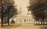
. The town is noted for its common
, part of the Petersham Historic District. About 45 buildings are listed on the National Register of Historic Places
. In July 2009, the Polus Center, a non-profit organization, announced it would close The Country Store which it owns. The store has been central to community life and in continuous operation for 163 years.
The town's lands were expanded greatly by the building of the Quabbin Reservoir
in 1938. When the towns of the Swift River Valley
were disincorporated, Petersham and neighboring New Salem
benefited the most, with Petersham receiving all of the former town of Dana
, much of the town of Greenwich
, and a small portion of the former town of Prescott
east of the Middle Branch of the Swift River. Its modern southwestern borders lie along the former East and Middle branches of the Swift River, and includes lands that were once part of Hampshire County
.
, the town has a total area of 68.3 square miles (176.9 km²), of which 54.2 square miles (140.4 km²) is land and 14.1 square miles (36.5 km²) (20.60%) is water. By virtue of the lands it gained in the construction of the Quabbin Reservoir, Petersham is the largest town by land area in Worcester County, and the fifth-largest town of the 351 cities and towns in the Commonwealth. It is the largest town by area in Central and Western Massachusetts
, with the four largest towns being in southeastern Massachusetts (Plymouth, Middleborough
, Dartmouth
and Barnstable
).
Much of the town's land is protected as part of the Quabbin Reservation, a protected area surrounding the Quabbin Reservoir
. The town's borders extend well into the eastern branch of the reservoir, and includes the lands around what were once Mount Pomeroy, Mount Zion (the largest such "island" in the reservoir), and several other former hills. The lands of the Reservation are only accessible on foot, and include the only disincorporated areas which are accessible to the public, at the former Dana Common, a 1.5 miles (2.4 km) walk from Gate 40. Most of the town still drains into the Quabbin, along brooks that once met the Swift River. The town has several other hills that are part of the larger Worcester Hills region, including Whitney Hill and Camels Hump Hill, at 1044 feet (318.2 m) the highest point in town. Several other parts of the town are also protected, including the Federated Women's Club State Forest, the Petersham State Forest, Harvard state Forest, the Popple Camp Wildlife Management Area, and the Phillipston Wildlife Management Area, the latter three extending into neighboring towns. Most of the town is rural in nature, with the largest population located near the town common.
Petersham, by virtue of its territory in the Quabbin, is the westernmost town in Worcester County, bordering Franklin County
to the west and a small portion of Hampshire County
to the south. Petersham is bordered by Athol
to the northwest, Phillipston
to the northeast, Barre
and Hardwick
to the southeast, Ware
to the south, and New Salem
to the west. From the town common, Petersham is 29 miles (46.7 km) northwest of Worcester
, 41 miles (66 km) north-northeast of Springfield
, and 66 miles (106.2 km) west-northwest of Boston
.
There are no interstates or other limited-access highways within town, with the nearest being Route 2, the major east-west route across northern Massachusetts, which lies just north of the town. Near the center of town lies the junction of Route 32 and Route 122, with Route 32 entering from Athol and Route 122 entering from New Salem. The routes pass concurrently into the town of Barre before splitting again in the southern part of that town. The town center is also the northern terminus of Route 32A, which heads southward through Hardwick, providing a more direct route from where Route 32 turns eastward in the Hardwick village of Gilbertville to the Petersham town center. Just north of the town center, the southern terminus of Route 101
lies along Route 32, heading into Phillipston along its route towards the New Hampshire border.
There are no means of mass transit in Petersham. The nearest general aviation airports are the Orange Municipal Airport
, Gardner Municipal Airport and Tanner-Hiller Airport
in Barre. The nearest national air service can be reached at Bradley International Airport
in Connecticut.
of 2000, there were 1,180 people, 438 households, and 299 families residing in the town. The population density
was 21.8 people per square mile (8.4/km²). There were 474 housing units at an average density of 8.7 per square mile (3.4/km²). The racial makeup of the town was 97.20% White, 0.68% African American, 0.76% Native American, 0.25% Asian, 0.08% from other races
, and 1.02% from two or more races. Hispanic or Latino of any race were 1.10% of the population.
There were 438 households out of which 29.5% had children under the age of 18 living with them, 59.6% were married couples
living together, 5.5% had a female householder with no husband present, and 31.7% were non-families. 27.2% of all households were made up of individuals and 11.4% had someone living alone who was 65 years of age or older. The average household size was 2.48 and the average family size was 3.04.
In the town the population was spread out with 22.4% under the age of 18, 4.3% from 18 to 24, 27.0% from 25 to 44, 28.7% from 45 to 64, and 17.5% who were 65 years of age or older. The median age was 43 years. For every 100 females there were 101.4 males. For every 100 females age 18 and over, there were 95.7 males.
The median income for a household in the town was $47,833, and the median income for a family was $58,125. Males had a median income of $39,265 versus $26,354 for females. The per capita income
for the town was $24,222. About 2.0% of families and 5.8% of the population were below the poverty line, including 4.2% of those under age 18 and 1.5% of those age 65 or over.
Worcester County, Massachusetts
-Demographics:In 1990 Worcester County had a population of 709,705.As of the census of 2000, there were 750,963 people, 283,927 households, and 192,502 families residing in the county. The population density was 496 people per square mile . There were 298,159 housing units at an average density...
, Massachusetts
Massachusetts
The Commonwealth of Massachusetts is a state in the New England region of the northeastern United States of America. It is bordered by Rhode Island and Connecticut to the south, New York to the west, and Vermont and New Hampshire to the north; at its east lies the Atlantic Ocean. As of the 2010...
, United States
United States
The United States of America is a federal constitutional republic comprising fifty states and a federal district...
. The population was 1,234 at the 2010 census. Petersham is home to a considerable amount of conservation land, including the Quabbin Reservation, Harvard Forest
Harvard Forest
Harvard Forest is an ecological research area of owned and managed by Harvard University and located in Petersham, Massachusetts. The property, in operation since 1907, includes one of North America's oldest managed forests, educational and research facilities, a museum, and recreation trails...
, the Swift River Reservation
Swift River Reservation
The Swift River Reservation is a open space preserve located in Petersham, Massachusetts, United States. The property, named after the East Branch of the Swift River , is managed by the land conservation non-profit organization The Trustees of Reservations and offers of trails available for...
, and Federated Women's Club State Forest
Federated Women's Club State Forest
Federated Women's Club State Forest is a Massachusetts state forest located in Petersham. The forest is managed by the Department of Conservation and Recreation .-Description:...
.
History
Petersham was first settled in 1733 and was officially incorporated in 1754. On February 4, 1787, it was the site of the second battle of Shays' RebellionShays' Rebellion
Shays' Rebellion was an armed uprising in central and western Massachusetts from 1786 to 1787. The rebellion is named after Daniel Shays, a veteran of the American Revolutionary War....
. The town is noted for its common
Common land
Common land is land owned collectively or by one person, but over which other people have certain traditional rights, such as to allow their livestock to graze upon it, to collect firewood, or to cut turf for fuel...
, part of the Petersham Historic District. About 45 buildings are listed on the National Register of Historic Places
National Register of Historic Places
The National Register of Historic Places is the United States government's official list of districts, sites, buildings, structures, and objects deemed worthy of preservation...
. In July 2009, the Polus Center, a non-profit organization, announced it would close The Country Store which it owns. The store has been central to community life and in continuous operation for 163 years.
The town's lands were expanded greatly by the building of the Quabbin Reservoir
Quabbin Reservoir
The Quabbin Reservoir is the largest inland body of water in the Commonwealth of Massachusetts and was built between 1930 and 1939. Today along with the Wachusett Reservoir, it is the primary water supply for Boston, some to the east, as well as 40 other communities in Greater Boston...
in 1938. When the towns of the Swift River Valley
Quabbin Valley
The Quabbin Valley is a region of Massachusetts, United States. The region consists of areas drained by the Quabbin Reservoir and accompanying river systems in Franklin, Hampden, Hampshire, and Worcester counties. The area is sometimes known as the Swift River Valley region, a reference to the...
were disincorporated, Petersham and neighboring New Salem
New Salem, Massachusetts
New Salem is a town in Franklin County, Massachusetts, United States. The population was 990 at the 2000 census. It is part of the Springfield, Massachusetts Metropolitan Statistical Area.- History :...
benefited the most, with Petersham receiving all of the former town of Dana
Dana, Massachusetts
Dana is a former town located in Worcester County, Massachusetts. Formed from parts of Petersham, Greenwich, and Hardwick, it was incorporated in 1801, and was disincorporated on April 28, 1938, as part of the creation of the Quabbin Reservoir. Upon disincorporation, most of the town was returned...
, much of the town of Greenwich
Greenwich, Massachusetts
Greenwich was a town in Hampshire County, Massachusetts.It was established in 1739 as Quabbin, incorporated as Quabbin Parish in 1754 and became the town of Greenwich in 1754. It was located along the East and Middle branches of the Swift River...
, and a small portion of the former town of Prescott
Prescott, Massachusetts
Prescott is a former town in Hampshire County, Massachusetts. It was incorporated in 1822 from portions of Pelham and New Salem. It was named in honor of Colonel William Prescott, who commanded the American forces at the Battle of Bunker Hill. It was disincorporated on April 28, 1938 as part of...
east of the Middle Branch of the Swift River. Its modern southwestern borders lie along the former East and Middle branches of the Swift River, and includes lands that were once part of Hampshire County
Hampshire County, Massachusetts
-Demographics:As of the census of 2000, there were 152,251 people, 55,991 households, and 33,818 families residing in the county. The population density was 288 people per square mile . There were 58,644 housing units at an average density of 111 per square mile...
.
Geography and transportation
According to the United States Census BureauUnited States Census Bureau
The United States Census Bureau is the government agency that is responsible for the United States Census. It also gathers other national demographic and economic data...
, the town has a total area of 68.3 square miles (176.9 km²), of which 54.2 square miles (140.4 km²) is land and 14.1 square miles (36.5 km²) (20.60%) is water. By virtue of the lands it gained in the construction of the Quabbin Reservoir, Petersham is the largest town by land area in Worcester County, and the fifth-largest town of the 351 cities and towns in the Commonwealth. It is the largest town by area in Central and Western Massachusetts
Western Massachusetts
Western Massachusetts is a loosely defined geographical region of the U.S. state of Massachusetts which contains the Berkshires, the Pioneer Valley, and some or all of the Swift River Valley. The region is always considered to include Berkshire, Franklin, Hampshire, and Hampden counties, and the...
, with the four largest towns being in southeastern Massachusetts (Plymouth, Middleborough
Middleborough, Massachusetts
Middleborough is a town in Plymouth County, Massachusetts, United States. The population was 21,117 as of 2008.For geographic and demographic information on the village of Middleborough Center, please see the article Middleborough Center, Massachusetts....
, Dartmouth
Dartmouth, Massachusetts
Dartmouth is a town in Bristol County, Massachusetts, United States established in 1664. The population was 30,665 at the 2000 census. It is the location of the University of Massachusetts Dartmouth....
and Barnstable
Barnstable, Massachusetts
Barnstable is a city, referred to as the Town of Barnstable, in the U.S. state of Massachusetts and the county seat of Barnstable County. Barnstable is the largest community, both in land area and population, on Cape Cod. The town contains seven villages within its boundaries...
).
Much of the town's land is protected as part of the Quabbin Reservation, a protected area surrounding the Quabbin Reservoir
Quabbin Reservoir
The Quabbin Reservoir is the largest inland body of water in the Commonwealth of Massachusetts and was built between 1930 and 1939. Today along with the Wachusett Reservoir, it is the primary water supply for Boston, some to the east, as well as 40 other communities in Greater Boston...
. The town's borders extend well into the eastern branch of the reservoir, and includes the lands around what were once Mount Pomeroy, Mount Zion (the largest such "island" in the reservoir), and several other former hills. The lands of the Reservation are only accessible on foot, and include the only disincorporated areas which are accessible to the public, at the former Dana Common, a 1.5 miles (2.4 km) walk from Gate 40. Most of the town still drains into the Quabbin, along brooks that once met the Swift River. The town has several other hills that are part of the larger Worcester Hills region, including Whitney Hill and Camels Hump Hill, at 1044 feet (318.2 m) the highest point in town. Several other parts of the town are also protected, including the Federated Women's Club State Forest, the Petersham State Forest, Harvard state Forest, the Popple Camp Wildlife Management Area, and the Phillipston Wildlife Management Area, the latter three extending into neighboring towns. Most of the town is rural in nature, with the largest population located near the town common.
Petersham, by virtue of its territory in the Quabbin, is the westernmost town in Worcester County, bordering Franklin County
Franklin County, Massachusetts
-Demographics:As of the census of 2000, there were 71,535 people, 29,466 households, and 18,416 families residing in the county. The population density was 102 people per square mile . There were 31,939 housing units at an average density of 46 per square mile...
to the west and a small portion of Hampshire County
Hampshire County, Massachusetts
-Demographics:As of the census of 2000, there were 152,251 people, 55,991 households, and 33,818 families residing in the county. The population density was 288 people per square mile . There were 58,644 housing units at an average density of 111 per square mile...
to the south. Petersham is bordered by Athol
Athol, Massachusetts
Athol is a town in Worcester County, Massachusetts, United States. The population was 11,584 at the 2010 census.-History:Originally called Pequoiag, the area was first settled by five families in September 1735. When the township was incorporated in 1762, the name was changed to Athol...
to the northwest, Phillipston
Phillipston, Massachusetts
Phillipston is a town in Worcester County, Massachusetts, United States. The population was 1,682 at the 2010 census.- History :Phillipston was first settled in 1751, and incorporated as the town of Gerry in 1786...
to the northeast, Barre
Barre, Massachusetts
Barre is a town in Worcester County, Massachusetts, United States. The population was 5,398 at the 2010 census.-History:Originally called the Northwest District of Rutland, it was first settled in 1720. The town was incorporated on June 17, 1774, as Hutchinson after Thomas Hutchinson, colonial...
and Hardwick
Hardwick, Massachusetts
Hardwick is a town in Worcester County, Massachusetts, United States, about west of the city of Worcester. It had a population of 2,990 at the 2010 census. It includes the villages of Hardwick, Gilbertville, Wheelwright and Old Furnace.- History :...
to the southeast, Ware
Ware, Massachusetts
Ware is a town in Hampshire County, Massachusetts, United States. The population was 9,707 at the 2000 census. It is part of the Springfield, Massachusetts Metropolitan Statistical Area.Part of the town comprises the census-designated place of Ware....
to the south, and New Salem
New Salem, Massachusetts
New Salem is a town in Franklin County, Massachusetts, United States. The population was 990 at the 2000 census. It is part of the Springfield, Massachusetts Metropolitan Statistical Area.- History :...
to the west. From the town common, Petersham is 29 miles (46.7 km) northwest of Worcester
Worcester, Massachusetts
Worcester is a city and the county seat of Worcester County, Massachusetts, United States. Named after Worcester, England, as of the 2010 Census the city's population is 181,045, making it the second largest city in New England after Boston....
, 41 miles (66 km) north-northeast of Springfield
Springfield, Massachusetts
Springfield is the most populous city in Western New England, and the seat of Hampden County, Massachusetts, United States. Springfield sits on the eastern bank of the Connecticut River near its confluence with three rivers; the western Westfield River, the eastern Chicopee River, and the eastern...
, and 66 miles (106.2 km) west-northwest of Boston
Boston
Boston is the capital of and largest city in Massachusetts, and is one of the oldest cities in the United States. The largest city in New England, Boston is regarded as the unofficial "Capital of New England" for its economic and cultural impact on the entire New England region. The city proper had...
.
There are no interstates or other limited-access highways within town, with the nearest being Route 2, the major east-west route across northern Massachusetts, which lies just north of the town. Near the center of town lies the junction of Route 32 and Route 122, with Route 32 entering from Athol and Route 122 entering from New Salem. The routes pass concurrently into the town of Barre before splitting again in the southern part of that town. The town center is also the northern terminus of Route 32A, which heads southward through Hardwick, providing a more direct route from where Route 32 turns eastward in the Hardwick village of Gilbertville to the Petersham town center. Just north of the town center, the southern terminus of Route 101
Massachusetts Route 101
Route 101 is a north–south state highway in Massachusetts.-Route description:Route 101 begins in Petersham at Route 32, just north of the center of town. The route heads eastward, winding between two wildlife management areas and south of Queen Lake as it passes through Phillipston...
lies along Route 32, heading into Phillipston along its route towards the New Hampshire border.
There are no means of mass transit in Petersham. The nearest general aviation airports are the Orange Municipal Airport
Orange Municipal Airport
Orange Municipal Airport, in Orange, Massachusetts, is a public airport owned by Town of Orange. It has two runways, averages 137 flights per day, and has approximately 52 aircraft based on its field.Flight training and parachuting services are available....
, Gardner Municipal Airport and Tanner-Hiller Airport
Tanner-Hiller Airport
Tanner-Hiller Airport, in Barre, Massachusetts, is a public airport owned by the Leonard A. Tanner Estate. It has one runway, averages 29 flights per week, and has approximately 4 aircraft based on its field....
in Barre. The nearest national air service can be reached at Bradley International Airport
Bradley International Airport
Bradley International Airport is a joint civil-military public airport located in Windsor Locks on the border with East Granby and Suffield, in Hartford County, Connecticut, United States. It is owned by the State of Connecticut....
in Connecticut.
Demographics
As of the censusCensus
A census is the procedure of systematically acquiring and recording information about the members of a given population. It is a regularly occurring and official count of a particular population. The term is used mostly in connection with national population and housing censuses; other common...
of 2000, there were 1,180 people, 438 households, and 299 families residing in the town. The population density
Population density
Population density is a measurement of population per unit area or unit volume. It is frequently applied to living organisms, and particularly to humans...
was 21.8 people per square mile (8.4/km²). There were 474 housing units at an average density of 8.7 per square mile (3.4/km²). The racial makeup of the town was 97.20% White, 0.68% African American, 0.76% Native American, 0.25% Asian, 0.08% from other races
Race (United States Census)
Race and ethnicity in the United States Census, as defined by the Federal Office of Management and Budget and the United States Census Bureau, are self-identification data items in which residents choose the race or races with which they most closely identify, and indicate whether or not they are...
, and 1.02% from two or more races. Hispanic or Latino of any race were 1.10% of the population.
There were 438 households out of which 29.5% had children under the age of 18 living with them, 59.6% were married couples
Marriage
Marriage is a social union or legal contract between people that creates kinship. It is an institution in which interpersonal relationships, usually intimate and sexual, are acknowledged in a variety of ways, depending on the culture or subculture in which it is found...
living together, 5.5% had a female householder with no husband present, and 31.7% were non-families. 27.2% of all households were made up of individuals and 11.4% had someone living alone who was 65 years of age or older. The average household size was 2.48 and the average family size was 3.04.
In the town the population was spread out with 22.4% under the age of 18, 4.3% from 18 to 24, 27.0% from 25 to 44, 28.7% from 45 to 64, and 17.5% who were 65 years of age or older. The median age was 43 years. For every 100 females there were 101.4 males. For every 100 females age 18 and over, there were 95.7 males.
The median income for a household in the town was $47,833, and the median income for a family was $58,125. Males had a median income of $39,265 versus $26,354 for females. The per capita income
Per capita income
Per capita income or income per person is a measure of mean income within an economic aggregate, such as a country or city. It is calculated by taking a measure of all sources of income in the aggregate and dividing it by the total population...
for the town was $24,222. About 2.0% of families and 5.8% of the population were below the poverty line, including 4.2% of those under age 18 and 1.5% of those age 65 or over.
Library
The Petersham public library began in 1879. In fiscal year 2008, the town of Petersham spent 0.35% ($10,752) of its budget on its public library—some $8 per person.Sites of interest
- Fisher Museum, Harvard Forest
- Petersham Historical Society Museum
- Petersham Curling Club
- Petersham Common web site www.petershamcommon.com
Notable residents
- Lewis BigelowLewis BigelowLewis Bigelow was a U.S. Representative from Massachusetts.Born in Petersham, Massachusetts, Bigelow was graduated from Williams College, Williamstown, Massachusetts, in 1803.He studied law....
, congressman - Yodelin' Slim ClarkYodelin' Slim ClarkRaymond LeRoy Clark was an American musician known for his yodeling. He was born in Springfield, Massachusetts, the son of Mr. and Mrs. Charles Clark. Slim completed two years of high school, at which time he became a professional musician at the age of 15 in 1932 - however, he was performing at...
, musician - Austin FlintAustin FlintAustin Flint was an American physician, born at Petersham, Massachusetts He was educated at Amherst and Harvard and graduated at the latter in 1833. After practicing at Boston and Northampton, he moved to Buffalo, N. Y., in 1836...
, physician - James HawkesJames Hawkes (congressman)James Hawkes was an American politician from New York.-Life:...
, congressman - Emmeline B. WellsEmmeline B. WellsEmmeline Blanche Woodward Harris Whitney Wells was an American journalist, editor, poet, women's rights advocate and diarist...
, journalist & activist