

Peoria, Arizona
Encyclopedia
Peoria is a city in Maricopa
and Yavapai
counties in the U.S. state
of Arizona
. Located primarily in Maricopa County, it is a major suburb of Phoenix
. According to 2010 Census Bureau releases, the population of the city is 154,065. Peoria is currently the sixth largest city in Arizona
for land area, and the ninth largest for population. It was named after Peoria
, Illinois
. (The word peoria is a corruption of the Illini word for “prairie fire”.) Peoria is now larger in population than its namesake. It is the spring training
home of the San Diego Padres
and Seattle Mariners
who share the Peoria Sports Complex
. In July 2008, Money
magazine listed Peoria in its "Top 100 Places to Live".
Valley, and extends into the foothills of the mountains to the north. Seasonal rainfall and runoff from mountain snowmelt
filled the Salt River, at times flooding the valley and wiping out months of backbreaking labor. If the area was to become habitable and productive all year, the cycle of flood
and drought
had to be replaced with a reliable supply of water that could be controlled year-round. The pioneers turned to irrigation
. In 1868 John W. “Jack” Swilling organized a group of men to dig the first modern irrigation ditch in the Salt River Valley. Their success enticed more people to settle in the area and reap the benefits of a revitalized irrigation system.
By 1872, there were eight thousand acres (32 km²) of land under cultivation in the valley and a thriving community had been built along the Salt River. Over the years irrigation companies sprung up and in the next three years three canal systems—the Maricopa, Grand, and Salt River Valley—were constructed, each allowing sustaining growth in the Valley. Visionary settlers began to imagine the potential income to be had by reclaiming the rich desert
lying higher up the slope above the recently completed Grand Canal; in 1882, the Arizona Canal Company was organized to do just that. The proposed canal would be larger than its approximately 80000 acres (323.7 km²)—including the site that would soon be Peoria—to a more consistent and regulated water system.
The Arizona Canal Company tapped William J. Murphy, a former Union Army
officer, to head construction on the 41 miles (66 km) canal. The young engineer from Illinois
had just completed the grading of a stretch of the Atlantic and Pacific Railway (which later became the Atchison, Topeka and Santa Fe Railway
). Unable to pay Murphy in cash, the canal company offered him land and water rights to a large amount of property as compensation. With vision and foresight, he accepted, and in 1885 the Arizona Canal was completed.
Murphy returned to Illinois to recruit settlers to transform the land into a sustainable farming community. Several residents of Peoria, Illinois, were enticed by descriptions of the area’s climate and agricultural potential and soon purchased 5000 acres (20.2 km²) among them. Four farming families left Illinois that fall to relocate to what is now Peoria. Before erecting simple adobe
homes, the settlers lived in large canvas tents. Peoria stood alone fourteen miles (21 km) from Phoenix
, at the time a frontier city of about 3,500 people. An old desert frightening road connecting Phoenix to the Hassayampa River near present-day Wickenburg
was the only major transportation route in the area until 1887, when a new road was laid out. This 100 feet (30.5 m) thoroughfare was named Grand Avenue, angled through the newly designed town sites of Alhambra, Glendale
, and Peoria and quickly became the main route from Phoenix to Vulture Mine
. The actual Peoria town site was owned by Joseph B. Greenhut and Deloss S. Brown. In 1890, the two men from Peoria, Illinois, acquired four sections of land from the government through the Desert Lands Act. They filed Peoria’s plot map with the Maricopa County recorder on May 24, 1897, naming the settlement after their hometown.
The original plot map of Peoria included east and west streets (from south to north) Monroe, Madison, Jefferson, Washington, Jackson, Lincoln, Grant, and Van Buren. Streets going north and south were (from west to east) Almond (present-day 85th Avenue), Peach (present-day 84th Avenue), Orange (present-day 83rd Avenue), Vine (present-day 82nd Avenue), Walnut (present-day 81st Avenue), the plot was roughly from present-day Peoria and 85th avenues to Monroe Street and 85th Avenue to Monroe Street and 81st Avenue to 81st Avenue and south of the Desert Cove alignment.
As soon as the proposed Peoria town site was surveyed a hand-dug water well
was sunk in 1889 on the public right-of-way at the intersection of Grand Avenue and Washington Street. A “town well” provided water for local residents as well as the traveling public. Five years later the well was refashioned into a water tower
and tank standing 89 feet (27.1 m) high. A social gathering place as well as source of water, the tower seemed to symbolize the young settlement’s growing sense of civic pride. On August 4, 1888 the Territory of Peoria, Arizona was granted a post office in its name and served a population of twenty-seven. Maricopa County supervisors defined the boundaries for School District Eleven, comprising forty-nine square miles, and the first class took place in an unoccupied brick store that faced north on Washington Street until Peoria’s first school building, a one-room structure completed in 1891. Attendance was erratic and thanks to a wagon full of nine children the district in question by county officials was saved.
on 83rd Avenue just off Grand Avenue. This enabled area ranchers and farmers to ship their cattle and crops from the town site, as well as bring goods into the city. The depot was sold to the city of Scottsdale
in 1972 where it now resides at McCormick Stillman Railroad Park.
In 1899 an atmosphere of permanence and stability for the settlement was created through the construction of the Presbyterian Church
. Dedicated in 1900, the church, built in the Gothic Revival
style and located at 83rd and Madison, is the oldest continuously used Presbyterian church in Arizona.
By 1917 Peoria, though still small, was slowly building into a solid commercial, agricultural, and residential location. Detracting from its growth, however, was its impermanent appearance, manifested in the tin and wood structures that had popped up around town in what was becoming known as the business district. Community leaders like J.A. Hammond and Frank Akin espoused changing the primary building material to brick
since it looked better and was relatively more stable. Hammond and Akin believed that for Peoria to be acknowledged as a viable community, it had to have more substantial and attractive buildings. Due to the expense of brick it was hard to convince local business owners to invest in brick buildings. Hammond and Akins led by example, tearing down their own stores to build three new buildings that were attached and made of brick.
operated by E.E. Stafford, near Wilhelm’s Garage. The cause of the fire was never determined, but the fire engulfed almost the entire business district including Hammond and Akins newly constructed buildings. Glendale and Phoenix firefighters responded to the alarm, but they were too late. The damage was so severe it was as though the entire town was wiped out. Peoria was devastated. Ironically, the fire that destroyed the town’s new brick stores was incentive other business owners needed to rebuild using more sound building techniques and materials. This fire began the new era of buildings that were sturdier and more pleasing to the eye. The timing of the fire was fortunate. The U.S. had entered World War I
just a few months before, leading to increased production and prices around the country, especially for agricultural products. Farmers had new money to spend, ambitious store owners hastened to reestablish their businesses to take advantage of the wartime prosperity and Peoria was rebuilt.
formed. It operated as the informal government body until Peoria’s incorporation in 1954. The Peoria volunteer fire district formed in 1920 and remained all volunteer until the mid-1950s. Peoria’s business district flourished. The three-story Edwards Hotel was built in 1918, followed by the Mabel Hood building in May 1920 at the southwest corner of Washington Street and 83rd Avenue. The John L. Meyer or “flatiron” building was completed in June 1920 and the O.O. Fuel’s Paramount Theatre in July 1920 (It served as Fire Station 1 from 1950 until 2004). The Peoria Woman’s Club House, erected in April 1918, became a center for community-wide activities. The town’s first newspaper, The Peoria Enterprise, was printed weekly from November 14, 1917, to April 1921.
Peoria’s first library
was held at the women’s club in 1920 until it moved to the old Peoria City Hall in 1975 (where the Peoria Center for the Performing Arts
was constructed and currently sits). The library eventually moved to the Peoria Municipal Complex. In May 1959 the Women’s Club gave the clubhouse to the City of Peoria where they meet free of rent.
Central School was built in 1906. The two-room masonry schoolhouse had hardwood
floors and ample storage closets and was surrounded by trees to shade the horses and mules. By 1910, three additional classroom buildings were built next to the central school, and in 1918 another large school building, containing an auditorium and four classrooms, was opened. In 1918 the attendance for Peoria schools was 190. Schools were set up in outlining areas in order to ease the difficulty in travel: there was the Morgan School, southwest of Peoria, with eighty-five students in 1918; Greenfield School, one mile (1.6 km) east and two miles (3 km) north of town with forty-five students; Bell School, to the northeast with thirty-nine students; and Marinette School, three miles (5 km) northwest with about twenty students.
School District Number Eleven was originally an elementary school
district. Children going on to high school
had to travel to Glendale High School
. As the student population of Peoria grew up, the need for education above the eighth grade level became apparent. In 1919 the school board approved construction of Peoria High School
. At the time many believed the three-story building designed to house the high school was too large and expensive, but when completed in 1922 had an enrollment of fifty which increased rapidly. It was built in the Spanish Mission
style and featured extravagant architectural elements of Moorish Spain.
During this time, agriculture around Peoria supported a diverse amount of crops. The town was the site of four cotton gin
s, the main one being built at 81st and Grand Avenue in the 1923. The town also had sheep ranching, citrus
farms, wheat
, corn
, rye
, and much more.
When cotton prices fell due to the Great Depression
it hit Peoria hard until a recession in 1939 due to the Second World War
. The New Deal
public works projects helped create jobs in Peoria including the construction of the Peoria High School gym in July 1936.
and tremendous growth throughout the entire Valley—coinciding with the mass-production of air conditioning
in the early 1950s—led to an increase in residential housing in Peoria. A postwar construction boom set the stage for Peoria to become a suburb
of Phoenix, providing housing for the capital city as growth moved west.
In 1954, Peoria was home to 1,925 residents, including an area of 720 acres (2.9 km²). The growing community's need for important services like water and sewage began to be more than the Chamber of Commerce, which served as its informal government, could provide. After much debate and skepticism Peoria incorporated on June 7, 1954. A seven member city council formed and held its first organizational meeting on June 14.
In 1955-56 a reliable house numbering system was established to help locate people more easily by street. In 1960 an outside development had major impacts on Peoria. Del Webb
began to develop Sun City
, which drew more residents to Peoria. By 1966 Peoria grew to encompass 3.1 square miles (8 km²) with 36 miles (57.9 km) of street. In 1968 the city passed a bond to issue securing the money to build a sewer
system, which was completed in 1969. In 1970, Peoria began to transition to paid firefighting staff.
From a population of 4,792 in 1970, the city grew to 12,351 in 1980 and 50,675 in 1990. The change from 1980 to 1990 alone represented a 300 percent increase in the city’s population. In order to support its new residents or better still, keep them off the roads and working in Peoria the city turned its focus to expand its commercial and ultimately industrial development in order to maintain a balanced local economy. The Peoria Economic Development Group (PEDG) was initiated and was instrumental in bringing Peoria its first ice skating
facility, modern movie theater
, and “Class A” office space.
Construction of the $30 million municipal complex began in 1988 at the edge of Peoria’s Old Town. The Police
Department opened in 1989, the main city hall building and courts in 1991, and the library in 1993.
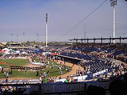
Spring training has a long history in Peoria. From the late 1970s to 1990, Peoria's Greenway Sports Complex served as a minor-league training facility for the Milwaukee Brewers
baseball team. This small facility was located at 83rd Avenue and the Greenway Road alignment, the location of the future Peoria Sports Complex
. Construction of the new complex was approved in 1990. It was completed in 1994 and was the first Major League Baseball
spring training
facility in the county shared by two teams. The San Diego Padres
and Seattle Mariners
utilize the complex year round for spring training and player development.
 The city invested heavily in the sports complex and continues to subsidize its operations each year. The stadium draws many tourists
, concerts, weddings, business events, boat tours, and festivals. This fuels the restaurants and hotels in the area. The stadium has helped make the 83rd Avenue and Bell/Arrowhead Fountains center area into the restaurant center of the West Valley which was estimated to have more restaurants in its quarter mile then any other in the U.S.. The stadium has more than paid for itself economically and with much of the land around it being owned by the city, selling of the land has increased city revenue and ensured the quality of the life for the area.
. Today most of the city’s growth is taking place in northern and northwestern Peoria with many infill projects occurring in Old Town and southern Peoria.
 The city in 2003 created a Drought Contingency Plan, and the Arizona Department of Water awarded Peoria as having Assured Water Supply, a designation that lasts until 2010. Additionally, Peoria became the first city in Arizona to use water availability rather than land mass for growth projections. In 1999 the Desert Lands Conservation Master Plan was adopted, and in May 2001 Peoria’s General Plan- the city’s blueprint for future growth and development-was approved by voters. In 2004, Peoria planners were creating a Desert Lands Conservation ordinance, which deals with hillside development, protection of native plants, and building setbacks from washes and other natural features. It provides a more comprehensive perspective when looking at development, considering the overall impact and seeking to provide the greatest amount of beneficial and conservation for both the public and the environment. Through separate development agreements, the city has managed to designate over 4000 acres (16.2 km²) of mountain preserves and open space to be enjoyed by all of Peoria.
Peoria is not just working on the untouched north but moving forward with some detailed plans to help revitalize the city’s historic center. The theatre was part of the project; other proactive steps for Old Town are the creation of the Façade Renovation and an Appearance Handbook to use in renovating the area. The results of some of these efforts will be seen over the course of many years, while others very soon.
"In January, 2010, four months after breaking ground, Stirling Energy partner company Tessara Solar completed the 1.5 MW Maricopa Solar power plant in Peoria, Arizona, just outside Phoenix. The power plant is 60 SES SunCatchers." The SunCatcher is described as "a large, tracking, concentrating solar power (CSP) dish collector that generates 25 kilowatts (kW) of electricity in full sun. Each of the 38-foot-diameter collectors contains over 300 curved mirrors (heliostat
s) that focus sunlight onto a power conversion unit, which contains the Stirling engine
. The dish uses dual-axis tracking to follow the sun precisely as it moves across the sky." Placed at the focus of a parabolic mirror a Stirling engine can convert solar energy
to electricity with an efficiency better than non-concentrated photovoltaic cells, and comparable to Concentrated Photo Voltaics.
Between 1990 and 2000 Peoria was the fifth fastest growing city in the United States with a population of over 100,000, increasing in population 114 percent. In 2004 Peoria was home to over 130,000 residents spread out over 170 square miles (440.3 km²). Growth, however, does pay for growth. Peoria charges impact fees to developers and requires economic impact analyses on major development projects.
Peoria's identity is more related to resort and leisure living than the past, as that type of lifestyle migrates from the northeast Valley to Peoria. Peoria’s economic plan focuses on establishing the new Loop 303 freeway corridor as an industrial, commercial, mixed development use and less on traditional residential development. In July 2008 Money Magazine
listed Peoria in the Top 100 Places to Live.
According to the United States Census Bureau
, the city has a total area of 141.7 square miles (367 km²), of which, 138.2 square miles (357.9 km²) of it is land and 3.5 square miles (9.1 km²) of it (2.44%) is water.
Peoria has now annexed over 170 square miles (440.3 km²) and is in two counties Maricopa County
and Yavapai County
. It is technically the largest incorporated city in Yavapai County even though almost all of Peoria’s current population resides on the Maricopa side.
The Agua Fria River and New River are the only rivers that flow through Peoria. The Agua Fria River is usually dry due to the New Waddell Dam that holding back Lake Pleasant in the northern end of the city. The New River is usually dry due to flood control measures and New River Dam. There are multiple washes and creeks that flow through the city as well, one of the most significant is the Skunk Creek due to its trails and connectivity with nearby Glendale.
Peoria has many mountains and hills in the northern end. Some include Sunrise Mountain, West Wing Mountain, East Wing Mountain, Calderwood Butte, Cholla Mountain, White Peak, Hieroglyphic Mountains, and Twin Buttes.
The street system of Peoria is based on the city of Phoenix traditional grid system, with most roads oriented either north-south or east-west. The zero point is in downtown Phoenix at Central Avenue and Washington Street. Since Peoria is always west of zero, its north-south numbered Streets are Avenues. Major arterial streets are spaced one mile (1.6 km) apart (until you are north of roughly Pinnacle Peak Road). The one-mile (1.6 km) blocks are divided into approximately 800 house numbers although this varies. 83rd Avenue, being 8300 West. The numbers in Phoenix start at Central Avenue at a half-mile increment, going west to 7th Avenue ½ mile from Central but considered the arterial. Then the numbers go to 19th (1 mile from 7th), 27th, 35th, 43rd, 51st, 59th, 67th (in many places Peoria’s eastern border), 75th, 83rd, 91st, 99th, and so on. In northern Peoria streets are more curvilinear and begin to not follow the north-south route due to rivers, mountains, and terrain challenges. The northern end of the city does still follow the alignment theory and still has blocking according to Phoenix.
of 2000, there were 108,364 people, 39,184 households, and 29,309 families residing in the city. The population density
was 784.0 people per square mile (302.7/km²). There were 42,573 housing units at an average density of 308.0 per square mile (118.9/km²). The racial makeup of the city was 84.95% White
, 2.78% Black
or African American
, 0.68% Native American
, 1.92% Asian
, 0.11% Pacific Islander
, 7.09% from other races
, and 2.48% from two or more races. 15.41% of the population were Hispanic
or Latino
of any race.
There were 39,184 households out of which 37.7% had children under the age of 18 living with them, 62.0% were married couples
living together, 9.1% had a female householder with no husband present, and 25.2% were non-families. 20.5% of all households were made up of individuals and 10.3% had someone living alone who was 65 years of age or older. The average household size was 2.73 and the average family size was 3.16.
In the city the population was spread out with 28.4% under the age of 18, 6.7% from 18 to 24, 30.6% from 25 to 44, 19.8% from 45 to 64, and 14.4% who were 65 years of age or older. The median age was 36 years. For every 100 females there were 92.5 males. For every 100 females age 18 and over, there were 88.0 males.
The median income for a household in the city was $52,199, and the median income for a family was $58,388. Males had a median income of $40,448 versus $29,205 for females. The per capita income
for the city was $22,726. About 3.3% of families and 5.3% of the population were below the poverty line, including 5.8% of those under age 18 and 6.3% of those age 65 or over.
 In November 1983, Peoria citizens voted to require the direct election of the mayor and in 1989, established a city council
district system that separated the city into six geographical districts, each of which elects one member of the city council. The districts are redrawn after every census. The current mayor is Bob Barrett. The current City Manager is Carl Swenson. Susan Thorpe and Susan Daluddung are the Deputy City Managers. The current Chief of Police is Roy Minter Jr. and the Fire Chief is Thomas Solberg. http://www.peoriaaz.gov/contentmenu4.asp?head=7249&id=52&Mname=Government
, however, some portions of the northeastern end of the city lie within the Deer Valley Unified School District
and portions of the northwestern end of the city lie within the Nadaburg Unified School District. PUSD has 7 high schools, 4 of which are within Peoria including:
PUSD Peoria High Schools
PUSD Glendale High Schools
PUSD elementary schools within the city limits are Alta Loma, Apache, Cheyenne, Copperwood, Cotton Boll, Country Meadows, Coyote Hills, Desert Harbor, Frontier, Ira Murphy, Lake Pleasant, Oakwood, Oasis, Parkridge, Paseo Verde, Peoria, Santa Fe, Sky View, Sun Valley, Sundance, Vistancia and Zuni Hills. Though the city of Peoria has 21 PUSD schools some students are in the boundaries of other PUSD schools located in Glendale city limits. 10 other PUSD schools fall within Glendale city limits.
DVUSD elementary schools within the city limits are Terramar and West Wing.
Additionally the city is well served by numerous publicly funded charter high schools and elementary schools.
 Ards, Northern Ireland
Maricopa County, Arizona
-2010:Whereas according to the 2010 U.S. Census Bureau:*73.0% White*5.0% Black*2.1% Native American*3.5% Asian*0.2% Native Hawaiian or Pacific Islander*3.5% Two or more races*12.7% Other races*29.6% Hispanic or Latino -2000:...
and Yavapai
Yavapai County, Arizona
-2010:Whereas according to the 2010 U.S. Census Bureau:*89.3% White*0.6% Black*1.7% Native American*0.8% Asian*0.1% Native Hawaiian or Pacific Islander*2.5% Two or more races*5.0% Other races*13.6% Hispanic or Latino -2000:...
counties in the U.S. state
U.S. state
A U.S. state is any one of the 50 federated states of the United States of America that share sovereignty with the federal government. Because of this shared sovereignty, an American is a citizen both of the federal entity and of his or her state of domicile. Four states use the official title of...
of Arizona
Arizona
Arizona ; is a state located in the southwestern region of the United States. It is also part of the western United States and the mountain west. The capital and largest city is Phoenix...
. Located primarily in Maricopa County, it is a major suburb of Phoenix
Phoenix, Arizona
Phoenix is the capital, and largest city, of the U.S. state of Arizona, as well as the sixth most populated city in the United States. Phoenix is home to 1,445,632 people according to the official 2010 U.S. Census Bureau data...
. According to 2010 Census Bureau releases, the population of the city is 154,065. Peoria is currently the sixth largest city in Arizona
Arizona
Arizona ; is a state located in the southwestern region of the United States. It is also part of the western United States and the mountain west. The capital and largest city is Phoenix...
for land area, and the ninth largest for population. It was named after Peoria
Peoria, Illinois
Peoria is the largest city on the Illinois River and the county seat of Peoria County, Illinois, in the United States. It is named after the Peoria tribe. As of the 2010 census, the city was the seventh-most populated in Illinois, with a population of 115,007, and is the third-most populated...
, Illinois
Illinois
Illinois is the fifth-most populous state of the United States of America, and is often noted for being a microcosm of the entire country. With Chicago in the northeast, small industrial cities and great agricultural productivity in central and northern Illinois, and natural resources like coal,...
. (The word peoria is a corruption of the Illini word for “prairie fire”.) Peoria is now larger in population than its namesake. It is the spring training
Spring training
In Major League Baseball, spring training is a series of practices and exhibition games preceding the start of the regular season. Spring training allows new players to try out for roster and position spots, and gives existing team players practice time prior to competitive play...
home of the San Diego Padres
San Diego Padres
The San Diego Padres are a Major League Baseball team based in San Diego, California. They play in the National League Western Division. Founded in 1969, the Padres have won the National League Pennant twice, in 1984 and 1998, losing in the World Series both times...
and Seattle Mariners
Seattle Mariners
The Seattle Mariners are a professional baseball team based in Seattle, Washington. Enfranchised in , the Mariners are a member of the Western Division of Major League Baseball's American League. Safeco Field has been the Mariners' home ballpark since July...
who share the Peoria Sports Complex
Peoria Sports Complex
The Peoria Sports Complex is a baseball complex located in Peoria, Arizona, near Peoria's main shopping district on Bell Road. It consists of the main baseball stadium and twelve practice fields. It is one of five facilities to host Arizona Fall League games...
. In July 2008, Money
Money Magazine
Money Magazine is a business news and financial programme that is broadcast on Sundays at 7:00pm in Hong Kong by television channel TVB Pearl.-Producers and reporters:...
magazine listed Peoria in its "Top 100 Places to Live".
Initial settlement
Peoria sits on flat gently sloping desert terrain in the Salt RiverSalt River (Arizona)
The Salt River is a stream in the U.S. state of Arizona. It is the largest tributary of the Gila River. The river is about long. Its drainage basin is about large. The longest of the Salt River's many tributaries is the Verde River...
Valley, and extends into the foothills of the mountains to the north. Seasonal rainfall and runoff from mountain snowmelt
Snowmelt
In hydrology, snowmelt is surface runoff produced from melting snow. It can also be used to describe the period or season during which such runoff is produced. Water produced by snowmelt is an important part of the annual water cycle in many parts of the world, in some cases contributing high...
filled the Salt River, at times flooding the valley and wiping out months of backbreaking labor. If the area was to become habitable and productive all year, the cycle of flood
Flood
A flood is an overflow of an expanse of water that submerges land. The EU Floods directive defines a flood as a temporary covering by water of land not normally covered by water...
and drought
Drought
A drought is an extended period of months or years when a region notes a deficiency in its water supply. Generally, this occurs when a region receives consistently below average precipitation. It can have a substantial impact on the ecosystem and agriculture of the affected region...
had to be replaced with a reliable supply of water that could be controlled year-round. The pioneers turned to irrigation
Irrigation
Irrigation may be defined as the science of artificial application of water to the land or soil. It is used to assist in the growing of agricultural crops, maintenance of landscapes, and revegetation of disturbed soils in dry areas and during periods of inadequate rainfall...
. In 1868 John W. “Jack” Swilling organized a group of men to dig the first modern irrigation ditch in the Salt River Valley. Their success enticed more people to settle in the area and reap the benefits of a revitalized irrigation system.
By 1872, there were eight thousand acres (32 km²) of land under cultivation in the valley and a thriving community had been built along the Salt River. Over the years irrigation companies sprung up and in the next three years three canal systems—the Maricopa, Grand, and Salt River Valley—were constructed, each allowing sustaining growth in the Valley. Visionary settlers began to imagine the potential income to be had by reclaiming the rich desert
Desert
A desert is a landscape or region that receives an extremely low amount of precipitation, less than enough to support growth of most plants. Most deserts have an average annual precipitation of less than...
lying higher up the slope above the recently completed Grand Canal; in 1882, the Arizona Canal Company was organized to do just that. The proposed canal would be larger than its approximately 80000 acres (323.7 km²)—including the site that would soon be Peoria—to a more consistent and regulated water system.
The Arizona Canal Company tapped William J. Murphy, a former Union Army
Union Army
The Union Army was the land force that fought for the Union during the American Civil War. It was also known as the Federal Army, the U.S. Army, the Northern Army and the National Army...
officer, to head construction on the 41 miles (66 km) canal. The young engineer from Illinois
Illinois
Illinois is the fifth-most populous state of the United States of America, and is often noted for being a microcosm of the entire country. With Chicago in the northeast, small industrial cities and great agricultural productivity in central and northern Illinois, and natural resources like coal,...
had just completed the grading of a stretch of the Atlantic and Pacific Railway (which later became the Atchison, Topeka and Santa Fe Railway
Atchison, Topeka and Santa Fe Railway
The Atchison, Topeka and Santa Fe Railway , often abbreviated as Santa Fe, was one of the larger railroads in the United States. The company was first chartered in February 1859...
). Unable to pay Murphy in cash, the canal company offered him land and water rights to a large amount of property as compensation. With vision and foresight, he accepted, and in 1885 the Arizona Canal was completed.
Murphy returned to Illinois to recruit settlers to transform the land into a sustainable farming community. Several residents of Peoria, Illinois, were enticed by descriptions of the area’s climate and agricultural potential and soon purchased 5000 acres (20.2 km²) among them. Four farming families left Illinois that fall to relocate to what is now Peoria. Before erecting simple adobe
Adobe
Adobe is a natural building material made from sand, clay, water, and some kind of fibrous or organic material , which the builders shape into bricks using frames and dry in the sun. Adobe buildings are similar to cob and mudbrick buildings. Adobe structures are extremely durable, and account for...
homes, the settlers lived in large canvas tents. Peoria stood alone fourteen miles (21 km) from Phoenix
Phoenix, Arizona
Phoenix is the capital, and largest city, of the U.S. state of Arizona, as well as the sixth most populated city in the United States. Phoenix is home to 1,445,632 people according to the official 2010 U.S. Census Bureau data...
, at the time a frontier city of about 3,500 people. An old desert frightening road connecting Phoenix to the Hassayampa River near present-day Wickenburg
Wickenburg, Arizona
Wickenburg is a town in Maricopa County, Arizona, United States. According to 2006 Census Bureau estimates, the population of the town is 6,423.-Geography:Wickenburg is located at ....
was the only major transportation route in the area until 1887, when a new road was laid out. This 100 feet (30.5 m) thoroughfare was named Grand Avenue, angled through the newly designed town sites of Alhambra, Glendale
Glendale, Arizona
Glendale is a city in Maricopa County, Arizona, USA, located about nine miles northwest from Downtown Phoenix. According to 2010 Census Bureau, the population of the city is 226,721....
, and Peoria and quickly became the main route from Phoenix to Vulture Mine
Vulture Mine
The Vulture Mine was a gold mine and settlement in Maricopa County, Arizona, United States. The mine began in 1863 and became the most productive gold mine in Arizona history. From 1863 to 1942, the mine produced 340,000 ounces of gold and 260,000 ounces of silver...
. The actual Peoria town site was owned by Joseph B. Greenhut and Deloss S. Brown. In 1890, the two men from Peoria, Illinois, acquired four sections of land from the government through the Desert Lands Act. They filed Peoria’s plot map with the Maricopa County recorder on May 24, 1897, naming the settlement after their hometown.
The original plot map of Peoria included east and west streets (from south to north) Monroe, Madison, Jefferson, Washington, Jackson, Lincoln, Grant, and Van Buren. Streets going north and south were (from west to east) Almond (present-day 85th Avenue), Peach (present-day 84th Avenue), Orange (present-day 83rd Avenue), Vine (present-day 82nd Avenue), Walnut (present-day 81st Avenue), the plot was roughly from present-day Peoria and 85th avenues to Monroe Street and 85th Avenue to Monroe Street and 81st Avenue to 81st Avenue and south of the Desert Cove alignment.
As soon as the proposed Peoria town site was surveyed a hand-dug water well
Water well
A water well is an excavation or structure created in the ground by digging, driving, boring or drilling to access groundwater in underground aquifers. The well water is drawn by an electric submersible pump, a trash pump, a vertical turbine pump, a handpump or a mechanical pump...
was sunk in 1889 on the public right-of-way at the intersection of Grand Avenue and Washington Street. A “town well” provided water for local residents as well as the traveling public. Five years later the well was refashioned into a water tower
Water tower
A water tower or elevated water tower is a large elevated drinking water storage container constructed to hold a water supply at a height sufficient to pressurize a water distribution system....
and tank standing 89 feet (27.1 m) high. A social gathering place as well as source of water, the tower seemed to symbolize the young settlement’s growing sense of civic pride. On August 4, 1888 the Territory of Peoria, Arizona was granted a post office in its name and served a population of twenty-seven. Maricopa County supervisors defined the boundaries for School District Eleven, comprising forty-nine square miles, and the first class took place in an unoccupied brick store that faced north on Washington Street until Peoria’s first school building, a one-room structure completed in 1891. Attendance was erratic and thanks to a wagon full of nine children the district in question by county officials was saved.
Early growth of the town
Between 1891 and 1895 a spur line of the Santa, Prescott and Phoenix Railroad was placed in Peoria along with Phoenix, Glendale, Alhambra, Hesperla, and Marinette. This line helped encourage continued development of Peoria and was beneficial to the community. Peoria persuaded the rail company to build a small depotTrain station
A train station, also called a railroad station or railway station and often shortened to just station,"Station" is commonly understood to mean "train station" unless otherwise qualified. This is evident from dictionary entries e.g...
on 83rd Avenue just off Grand Avenue. This enabled area ranchers and farmers to ship their cattle and crops from the town site, as well as bring goods into the city. The depot was sold to the city of Scottsdale
Scottsdale, Arizona
Scottsdale is a city in the eastern part of Maricopa County, Arizona, United States, adjacent to Phoenix. According to the U.S. Census Bureau, as of 2010 the population of the city was 217,385...
in 1972 where it now resides at McCormick Stillman Railroad Park.
In 1899 an atmosphere of permanence and stability for the settlement was created through the construction of the Presbyterian Church
Presbyterianism
Presbyterianism refers to a number of Christian churches adhering to the Calvinist theological tradition within Protestantism, which are organized according to a characteristic Presbyterian polity. Presbyterian theology typically emphasizes the sovereignty of God, the authority of the Scriptures,...
. Dedicated in 1900, the church, built in the Gothic Revival
Gothic Revival architecture
The Gothic Revival is an architectural movement that began in the 1740s in England...
style and located at 83rd and Madison, is the oldest continuously used Presbyterian church in Arizona.
By 1917 Peoria, though still small, was slowly building into a solid commercial, agricultural, and residential location. Detracting from its growth, however, was its impermanent appearance, manifested in the tin and wood structures that had popped up around town in what was becoming known as the business district. Community leaders like J.A. Hammond and Frank Akin espoused changing the primary building material to brick
Brick
A brick is a block of ceramic material used in masonry construction, usually laid using various kinds of mortar. It has been regarded as one of the longest lasting and strongest building materials used throughout history.-History:...
since it looked better and was relatively more stable. Hammond and Akin believed that for Peoria to be acknowledged as a viable community, it had to have more substantial and attractive buildings. Due to the expense of brick it was hard to convince local business owners to invest in brick buildings. Hammond and Akins led by example, tearing down their own stores to build three new buildings that were attached and made of brick.
Fire
In July 1917, a fire broke out in a pool hallPool hall
A billiard/billiards, pool or snooker hall is a place where people get together for playing cue sports such as pool, snooker or carom billiards...
operated by E.E. Stafford, near Wilhelm’s Garage. The cause of the fire was never determined, but the fire engulfed almost the entire business district including Hammond and Akins newly constructed buildings. Glendale and Phoenix firefighters responded to the alarm, but they were too late. The damage was so severe it was as though the entire town was wiped out. Peoria was devastated. Ironically, the fire that destroyed the town’s new brick stores was incentive other business owners needed to rebuild using more sound building techniques and materials. This fire began the new era of buildings that were sturdier and more pleasing to the eye. The timing of the fire was fortunate. The U.S. had entered World War I
World War I
World War I , which was predominantly called the World War or the Great War from its occurrence until 1939, and the First World War or World War I thereafter, was a major war centred in Europe that began on 28 July 1914 and lasted until 11 November 1918...
just a few months before, leading to increased production and prices around the country, especially for agricultural products. Farmers had new money to spend, ambitious store owners hastened to reestablish their businesses to take advantage of the wartime prosperity and Peoria was rebuilt.
Early 20th century
About 1919 the Peoria Chamber of CommerceChamber of commerce
A chamber of commerce is a form of business network, e.g., a local organization of businesses whose goal is to further the interests of businesses. Business owners in towns and cities form these local societies to advocate on behalf of the business community...
formed. It operated as the informal government body until Peoria’s incorporation in 1954. The Peoria volunteer fire district formed in 1920 and remained all volunteer until the mid-1950s. Peoria’s business district flourished. The three-story Edwards Hotel was built in 1918, followed by the Mabel Hood building in May 1920 at the southwest corner of Washington Street and 83rd Avenue. The John L. Meyer or “flatiron” building was completed in June 1920 and the O.O. Fuel’s Paramount Theatre in July 1920 (It served as Fire Station 1 from 1950 until 2004). The Peoria Woman’s Club House, erected in April 1918, became a center for community-wide activities. The town’s first newspaper, The Peoria Enterprise, was printed weekly from November 14, 1917, to April 1921.
Peoria’s first library
Library
In a traditional sense, a library is a large collection of books, and can refer to the place in which the collection is housed. Today, the term can refer to any collection, including digital sources, resources, and services...
was held at the women’s club in 1920 until it moved to the old Peoria City Hall in 1975 (where the Peoria Center for the Performing Arts
Peoria Center for the Performing Arts
The Peoria Center for the Performing Arts is a 250 seat theater in Peoria, Arizona. It opened in December 2006 and is operated by the acting company "Theater Works".Received Best New Playhouse in 2008 by Phoenix New Times.Best New Playhouse....
was constructed and currently sits). The library eventually moved to the Peoria Municipal Complex. In May 1959 the Women’s Club gave the clubhouse to the City of Peoria where they meet free of rent.
Central School was built in 1906. The two-room masonry schoolhouse had hardwood
Hardwood
Hardwood is wood from angiosperm trees . It may also be used for those trees themselves: these are usually broad-leaved; in temperate and boreal latitudes they are mostly deciduous, but in tropics and subtropics mostly evergreen.Hardwood contrasts with softwood...
floors and ample storage closets and was surrounded by trees to shade the horses and mules. By 1910, three additional classroom buildings were built next to the central school, and in 1918 another large school building, containing an auditorium and four classrooms, was opened. In 1918 the attendance for Peoria schools was 190. Schools were set up in outlining areas in order to ease the difficulty in travel: there was the Morgan School, southwest of Peoria, with eighty-five students in 1918; Greenfield School, one mile (1.6 km) east and two miles (3 km) north of town with forty-five students; Bell School, to the northeast with thirty-nine students; and Marinette School, three miles (5 km) northwest with about twenty students.
School District Number Eleven was originally an elementary school
Elementary school
An elementary school or primary school is an institution where children receive the first stage of compulsory education known as elementary or primary education. Elementary school is the preferred term in some countries, particularly those in North America, where the terms grade school and grammar...
district. Children going on to high school
High school
High school is a term used in parts of the English speaking world to describe institutions which provide all or part of secondary education. The term is often incorporated into the name of such institutions....
had to travel to Glendale High School
Glendale High School (Glendale, Arizona)
Glendale High School is located in Glendale, Arizona and is part of the Glendale Union High School District. It was founded in 1911 and is the oldest high school in Arizona that is still on its original site, having established itself at Glendale and Grand avenues in the fall of 1912.The high...
. As the student population of Peoria grew up, the need for education above the eighth grade level became apparent. In 1919 the school board approved construction of Peoria High School
Peoria High School (Arizona)
Peoria High School is a public secondary school located in Peoria, Arizona, United States. The high school is currently a part of the Peoria Unified School District. The school opened its doors in August 1919, since which it has maintained an Excelling academic status...
. At the time many believed the three-story building designed to house the high school was too large and expensive, but when completed in 1922 had an enrollment of fifty which increased rapidly. It was built in the Spanish Mission
Mission Revival Style architecture
The Mission Revival Style was an architectural movement that began in the late 19th century for a colonial style's revivalism and reinterpretation, which drew inspiration from the late 18th and early 19th century Spanish missions in California....
style and featured extravagant architectural elements of Moorish Spain.
During this time, agriculture around Peoria supported a diverse amount of crops. The town was the site of four cotton gin
Cotton gin
A cotton gin is a machine that quickly and easily separates cotton fibers from their seeds, a job formerly performed painstakingly by hand...
s, the main one being built at 81st and Grand Avenue in the 1923. The town also had sheep ranching, citrus
Citrus
Citrus is a common term and genus of flowering plants in the rue family, Rutaceae. Citrus is believed to have originated in the part of Southeast Asia bordered by Northeastern India, Myanmar and the Yunnan province of China...
farms, wheat
Wheat
Wheat is a cereal grain, originally from the Levant region of the Near East, but now cultivated worldwide. In 2007 world production of wheat was 607 million tons, making it the third most-produced cereal after maize and rice...
, corn
Maize
Maize known in many English-speaking countries as corn or mielie/mealie, is a grain domesticated by indigenous peoples in Mesoamerica in prehistoric times. The leafy stalk produces ears which contain seeds called kernels. Though technically a grain, maize kernels are used in cooking as a vegetable...
, rye
Rye
Rye is a grass grown extensively as a grain and as a forage crop. It is a member of the wheat tribe and is closely related to barley and wheat. Rye grain is used for flour, rye bread, rye beer, some whiskeys, some vodkas, and animal fodder...
, and much more.
When cotton prices fell due to the Great Depression
Great Depression
The Great Depression was a severe worldwide economic depression in the decade preceding World War II. The timing of the Great Depression varied across nations, but in most countries it started in about 1929 and lasted until the late 1930s or early 1940s...
it hit Peoria hard until a recession in 1939 due to the Second World War
World War II
World War II, or the Second World War , was a global conflict lasting from 1939 to 1945, involving most of the world's nations—including all of the great powers—eventually forming two opposing military alliances: the Allies and the Axis...
. The New Deal
New Deal
The New Deal was a series of economic programs implemented in the United States between 1933 and 1936. They were passed by the U.S. Congress during the first term of President Franklin D. Roosevelt. The programs were Roosevelt's responses to the Great Depression, and focused on what historians call...
public works projects helped create jobs in Peoria including the construction of the Peoria High School gym in July 1936.
Post-war development
Increased economic activity, combined with the presence of Luke Air Force BaseLuke Air Force Base
Luke Air Force Base is a United States Air Force base located seven miles west of the central business district of Glendale, in Maricopa County, Arizona, United States. It is also about west of Phoenix, Arizona....
and tremendous growth throughout the entire Valley—coinciding with the mass-production of air conditioning
Air conditioning
An air conditioner is a home appliance, system, or mechanism designed to dehumidify and extract heat from an area. The cooling is done using a simple refrigeration cycle...
in the early 1950s—led to an increase in residential housing in Peoria. A postwar construction boom set the stage for Peoria to become a suburb
Suburb
The word suburb mostly refers to a residential area, either existing as part of a city or as a separate residential community within commuting distance of a city . Some suburbs have a degree of administrative autonomy, and most have lower population density than inner city neighborhoods...
of Phoenix, providing housing for the capital city as growth moved west.
In 1954, Peoria was home to 1,925 residents, including an area of 720 acres (2.9 km²). The growing community's need for important services like water and sewage began to be more than the Chamber of Commerce, which served as its informal government, could provide. After much debate and skepticism Peoria incorporated on June 7, 1954. A seven member city council formed and held its first organizational meeting on June 14.
In 1955-56 a reliable house numbering system was established to help locate people more easily by street. In 1960 an outside development had major impacts on Peoria. Del Webb
Del Webb
Delbert Eugene Webb was an American construction magnate, real estate developer and sports-team owner, who is most significant for founding and developing the retirement community of Sun City, Arizona.-Early life:...
began to develop Sun City
Sun City, Arizona
Sun City is a census-designated place and unincorporated town in Maricopa County, Arizona, United States. The population was 38,309 at the 2000 census...
, which drew more residents to Peoria. By 1966 Peoria grew to encompass 3.1 square miles (8 km²) with 36 miles (57.9 km) of street. In 1968 the city passed a bond to issue securing the money to build a sewer
Sanitary sewer
A sanitary sewer is a separate underground carriage system specifically for transporting sewage from houses and commercial buildings to treatment or disposal. Sanitary sewers serving industrial areas also carry industrial wastewater...
system, which was completed in 1969. In 1970, Peoria began to transition to paid firefighting staff.
From a population of 4,792 in 1970, the city grew to 12,351 in 1980 and 50,675 in 1990. The change from 1980 to 1990 alone represented a 300 percent increase in the city’s population. In order to support its new residents or better still, keep them off the roads and working in Peoria the city turned its focus to expand its commercial and ultimately industrial development in order to maintain a balanced local economy. The Peoria Economic Development Group (PEDG) was initiated and was instrumental in bringing Peoria its first ice skating
Ice skating
Ice skating is moving on ice by using ice skates. It can be done for a variety of reasons, including leisure, traveling, and various sports. Ice skating occurs both on specially prepared indoor and outdoor tracks, as well as on naturally occurring bodies of frozen water, such as lakes and...
facility, modern movie theater
Movie theater
A movie theater, cinema, movie house, picture theater, film theater is a venue, usually a building, for viewing motion pictures ....
, and “Class A” office space.
Construction of the $30 million municipal complex began in 1988 at the edge of Peoria’s Old Town. The Police
Police
The police is a personification of the state designated to put in practice the enforced law, protect property and reduce civil disorder in civilian matters. Their powers include the legitimized use of force...
Department opened in 1989, the main city hall building and courts in 1991, and the library in 1993.
Spring training has a long history in Peoria. From the late 1970s to 1990, Peoria's Greenway Sports Complex served as a minor-league training facility for the Milwaukee Brewers
Milwaukee Brewers
The Milwaukee Brewers are a professional baseball team based in Milwaukee, Wisconsin, currently playing in the Central Division of Major League Baseball's National League...
baseball team. This small facility was located at 83rd Avenue and the Greenway Road alignment, the location of the future Peoria Sports Complex
Peoria Sports Complex
The Peoria Sports Complex is a baseball complex located in Peoria, Arizona, near Peoria's main shopping district on Bell Road. It consists of the main baseball stadium and twelve practice fields. It is one of five facilities to host Arizona Fall League games...
. Construction of the new complex was approved in 1990. It was completed in 1994 and was the first Major League Baseball
Major League Baseball
Major League Baseball is the highest level of professional baseball in the United States and Canada, consisting of teams that play in the National League and the American League...
spring training
Spring training
In Major League Baseball, spring training is a series of practices and exhibition games preceding the start of the regular season. Spring training allows new players to try out for roster and position spots, and gives existing team players practice time prior to competitive play...
facility in the county shared by two teams. The San Diego Padres
San Diego Padres
The San Diego Padres are a Major League Baseball team based in San Diego, California. They play in the National League Western Division. Founded in 1969, the Padres have won the National League Pennant twice, in 1984 and 1998, losing in the World Series both times...
and Seattle Mariners
Seattle Mariners
The Seattle Mariners are a professional baseball team based in Seattle, Washington. Enfranchised in , the Mariners are a member of the Western Division of Major League Baseball's American League. Safeco Field has been the Mariners' home ballpark since July...
utilize the complex year round for spring training and player development.
Tourism
Tourism is travel for recreational, leisure or business purposes. The World Tourism Organization defines tourists as people "traveling to and staying in places outside their usual environment for not more than one consecutive year for leisure, business and other purposes".Tourism has become a...
, concerts, weddings, business events, boat tours, and festivals. This fuels the restaurants and hotels in the area. The stadium has helped make the 83rd Avenue and Bell/Arrowhead Fountains center area into the restaurant center of the West Valley which was estimated to have more restaurants in its quarter mile then any other in the U.S.. The stadium has more than paid for itself economically and with much of the land around it being owned by the city, selling of the land has increased city revenue and ensured the quality of the life for the area.
Current developments
Peoria continues to grow successfully. In 1999 most of the land around Lake Pleasant Regional Park was annexed into the city. Peoria has gained a world-class educational and cultural destination, the Challenger Space Center of Arizona. Also in 2007 the city completed the Peoria Center for the Performing ArtsPeoria Center for the Performing Arts
The Peoria Center for the Performing Arts is a 250 seat theater in Peoria, Arizona. It opened in December 2006 and is operated by the acting company "Theater Works".Received Best New Playhouse in 2008 by Phoenix New Times.Best New Playhouse....
. Today most of the city’s growth is taking place in northern and northwestern Peoria with many infill projects occurring in Old Town and southern Peoria.
Peoria is not just working on the untouched north but moving forward with some detailed plans to help revitalize the city’s historic center. The theatre was part of the project; other proactive steps for Old Town are the creation of the Façade Renovation and an Appearance Handbook to use in renovating the area. The results of some of these efforts will be seen over the course of many years, while others very soon.
"In January, 2010, four months after breaking ground, Stirling Energy partner company Tessara Solar completed the 1.5 MW Maricopa Solar power plant in Peoria, Arizona, just outside Phoenix. The power plant is 60 SES SunCatchers." The SunCatcher is described as "a large, tracking, concentrating solar power (CSP) dish collector that generates 25 kilowatts (kW) of electricity in full sun. Each of the 38-foot-diameter collectors contains over 300 curved mirrors (heliostat
Heliostat
A heliostat is a device that includes a mirror, usually a plane mirror, which turns so as to keep reflecting sunlight toward a predetermined target, compensating for the sun's apparent motions in the sky. The target may be a physical object, distant from the heliostat, or a direction in space...
s) that focus sunlight onto a power conversion unit, which contains the Stirling engine
Stirling engine
A Stirling engine is a heat engine operating by cyclic compression and expansion of air or other gas, the working fluid, at different temperature levels such that there is a net conversion of heat energy to mechanical work....
. The dish uses dual-axis tracking to follow the sun precisely as it moves across the sky." Placed at the focus of a parabolic mirror a Stirling engine can convert solar energy
Solar power
Solar energy, radiant light and heat from the sun, has been harnessed by humans since ancient times using a range of ever-evolving technologies. Solar radiation, along with secondary solar-powered resources such as wind and wave power, hydroelectricity and biomass, account for most of the available...
to electricity with an efficiency better than non-concentrated photovoltaic cells, and comparable to Concentrated Photo Voltaics.
Between 1990 and 2000 Peoria was the fifth fastest growing city in the United States with a population of over 100,000, increasing in population 114 percent. In 2004 Peoria was home to over 130,000 residents spread out over 170 square miles (440.3 km²). Growth, however, does pay for growth. Peoria charges impact fees to developers and requires economic impact analyses on major development projects.
Peoria's identity is more related to resort and leisure living than the past, as that type of lifestyle migrates from the northeast Valley to Peoria. Peoria’s economic plan focuses on establishing the new Loop 303 freeway corridor as an industrial, commercial, mixed development use and less on traditional residential development. In July 2008 Money Magazine
Money Magazine
Money Magazine is a business news and financial programme that is broadcast on Sundays at 7:00pm in Hong Kong by television channel TVB Pearl.-Producers and reporters:...
listed Peoria in the Top 100 Places to Live.
Geography
Peoria is located at 33°34′57"N 112°14′19"W (33.582439, -112.238548).According to the United States Census Bureau
United States Census Bureau
The United States Census Bureau is the government agency that is responsible for the United States Census. It also gathers other national demographic and economic data...
, the city has a total area of 141.7 square miles (367 km²), of which, 138.2 square miles (357.9 km²) of it is land and 3.5 square miles (9.1 km²) of it (2.44%) is water.
Peoria has now annexed over 170 square miles (440.3 km²) and is in two counties Maricopa County
Maricopa County, Arizona
-2010:Whereas according to the 2010 U.S. Census Bureau:*73.0% White*5.0% Black*2.1% Native American*3.5% Asian*0.2% Native Hawaiian or Pacific Islander*3.5% Two or more races*12.7% Other races*29.6% Hispanic or Latino -2000:...
and Yavapai County
Yavapai County, Arizona
-2010:Whereas according to the 2010 U.S. Census Bureau:*89.3% White*0.6% Black*1.7% Native American*0.8% Asian*0.1% Native Hawaiian or Pacific Islander*2.5% Two or more races*5.0% Other races*13.6% Hispanic or Latino -2000:...
. It is technically the largest incorporated city in Yavapai County even though almost all of Peoria’s current population resides on the Maricopa side.
The Agua Fria River and New River are the only rivers that flow through Peoria. The Agua Fria River is usually dry due to the New Waddell Dam that holding back Lake Pleasant in the northern end of the city. The New River is usually dry due to flood control measures and New River Dam. There are multiple washes and creeks that flow through the city as well, one of the most significant is the Skunk Creek due to its trails and connectivity with nearby Glendale.
Peoria has many mountains and hills in the northern end. Some include Sunrise Mountain, West Wing Mountain, East Wing Mountain, Calderwood Butte, Cholla Mountain, White Peak, Hieroglyphic Mountains, and Twin Buttes.
The street system of Peoria is based on the city of Phoenix traditional grid system, with most roads oriented either north-south or east-west. The zero point is in downtown Phoenix at Central Avenue and Washington Street. Since Peoria is always west of zero, its north-south numbered Streets are Avenues. Major arterial streets are spaced one mile (1.6 km) apart (until you are north of roughly Pinnacle Peak Road). The one-mile (1.6 km) blocks are divided into approximately 800 house numbers although this varies. 83rd Avenue, being 8300 West. The numbers in Phoenix start at Central Avenue at a half-mile increment, going west to 7th Avenue ½ mile from Central but considered the arterial. Then the numbers go to 19th (1 mile from 7th), 27th, 35th, 43rd, 51st, 59th, 67th (in many places Peoria’s eastern border), 75th, 83rd, 91st, 99th, and so on. In northern Peoria streets are more curvilinear and begin to not follow the north-south route due to rivers, mountains, and terrain challenges. The northern end of the city does still follow the alignment theory and still has blocking according to Phoenix.
Climate
Demographics
As of the censusCensus
A census is the procedure of systematically acquiring and recording information about the members of a given population. It is a regularly occurring and official count of a particular population. The term is used mostly in connection with national population and housing censuses; other common...
of 2000, there were 108,364 people, 39,184 households, and 29,309 families residing in the city. The population density
Population density
Population density is a measurement of population per unit area or unit volume. It is frequently applied to living organisms, and particularly to humans...
was 784.0 people per square mile (302.7/km²). There were 42,573 housing units at an average density of 308.0 per square mile (118.9/km²). The racial makeup of the city was 84.95% White
Race (United States Census)
Race and ethnicity in the United States Census, as defined by the Federal Office of Management and Budget and the United States Census Bureau, are self-identification data items in which residents choose the race or races with which they most closely identify, and indicate whether or not they are...
, 2.78% Black
Race (United States Census)
Race and ethnicity in the United States Census, as defined by the Federal Office of Management and Budget and the United States Census Bureau, are self-identification data items in which residents choose the race or races with which they most closely identify, and indicate whether or not they are...
or African American
Race (United States Census)
Race and ethnicity in the United States Census, as defined by the Federal Office of Management and Budget and the United States Census Bureau, are self-identification data items in which residents choose the race or races with which they most closely identify, and indicate whether or not they are...
, 0.68% Native American
Race (United States Census)
Race and ethnicity in the United States Census, as defined by the Federal Office of Management and Budget and the United States Census Bureau, are self-identification data items in which residents choose the race or races with which they most closely identify, and indicate whether or not they are...
, 1.92% Asian
Race (United States Census)
Race and ethnicity in the United States Census, as defined by the Federal Office of Management and Budget and the United States Census Bureau, are self-identification data items in which residents choose the race or races with which they most closely identify, and indicate whether or not they are...
, 0.11% Pacific Islander
Race (United States Census)
Race and ethnicity in the United States Census, as defined by the Federal Office of Management and Budget and the United States Census Bureau, are self-identification data items in which residents choose the race or races with which they most closely identify, and indicate whether or not they are...
, 7.09% from other races
Race (United States Census)
Race and ethnicity in the United States Census, as defined by the Federal Office of Management and Budget and the United States Census Bureau, are self-identification data items in which residents choose the race or races with which they most closely identify, and indicate whether or not they are...
, and 2.48% from two or more races. 15.41% of the population were Hispanic
Race (United States Census)
Race and ethnicity in the United States Census, as defined by the Federal Office of Management and Budget and the United States Census Bureau, are self-identification data items in which residents choose the race or races with which they most closely identify, and indicate whether or not they are...
or Latino
Race (United States Census)
Race and ethnicity in the United States Census, as defined by the Federal Office of Management and Budget and the United States Census Bureau, are self-identification data items in which residents choose the race or races with which they most closely identify, and indicate whether or not they are...
of any race.
There were 39,184 households out of which 37.7% had children under the age of 18 living with them, 62.0% were married couples
Marriage
Marriage is a social union or legal contract between people that creates kinship. It is an institution in which interpersonal relationships, usually intimate and sexual, are acknowledged in a variety of ways, depending on the culture or subculture in which it is found...
living together, 9.1% had a female householder with no husband present, and 25.2% were non-families. 20.5% of all households were made up of individuals and 10.3% had someone living alone who was 65 years of age or older. The average household size was 2.73 and the average family size was 3.16.
In the city the population was spread out with 28.4% under the age of 18, 6.7% from 18 to 24, 30.6% from 25 to 44, 19.8% from 45 to 64, and 14.4% who were 65 years of age or older. The median age was 36 years. For every 100 females there were 92.5 males. For every 100 females age 18 and over, there were 88.0 males.
The median income for a household in the city was $52,199, and the median income for a family was $58,388. Males had a median income of $40,448 versus $29,205 for females. The per capita income
Per capita income
Per capita income or income per person is a measure of mean income within an economic aggregate, such as a country or city. It is calculated by taking a measure of all sources of income in the aggregate and dividing it by the total population...
for the city was $22,726. About 3.3% of families and 5.3% of the population were below the poverty line, including 5.8% of those under age 18 and 6.3% of those age 65 or over.
Government
City council
A city council or town council is the legislative body that governs a city, town, municipality or local government area.-Australia & NZ:Because of the differences in legislation between the States, the exact definition of a City Council varies...
district system that separated the city into six geographical districts, each of which elects one member of the city council. The districts are redrawn after every census. The current mayor is Bob Barrett. The current City Manager is Carl Swenson. Susan Thorpe and Susan Daluddung are the Deputy City Managers. The current Chief of Police is Roy Minter Jr. and the Fire Chief is Thomas Solberg. http://www.peoriaaz.gov/contentmenu4.asp?head=7249&id=52&Mname=Government
Education
Peoria city limits lie mainly in the Peoria Unified School DistrictPeoria Unified School District
Peoria Unified School District #11 provides primary and secondary education for most of Peoria, Arizona, parts of Glendale and Youngtown, Arizona, and a small portion of Surprise, Arizona, and northwestern Maricopa County. With 39 schools, it is the third largest school district in Arizona.-Early...
, however, some portions of the northeastern end of the city lie within the Deer Valley Unified School District
Deer Valley Unified School District
Deer Valley Unified School District is a PreK-12 school district, headquartered in Phoenix, Arizona. DVUSD is the fifth largest school district in the state of Arizona, serving portions of Phoenix, Glendale, Peoria, Anthem, New River, Cave Creek and unincorporated areas of northwest Maricopa County...
and portions of the northwestern end of the city lie within the Nadaburg Unified School District. PUSD has 7 high schools, 4 of which are within Peoria including:
PUSD Peoria High Schools
- Peoria High SchoolPeoria High School (Arizona)Peoria High School is a public secondary school located in Peoria, Arizona, United States. The high school is currently a part of the Peoria Unified School District. The school opened its doors in August 1919, since which it has maintained an Excelling academic status...
,(PUSD) 1922 - Centennial High School,(PUSD) 1990
- Sunrise Mountain High SchoolSunrise Mountain High SchoolSunrise Mountain High School is a public secondary school located in Peoria, Arizona, United States. The high school is currently a part of the Peoria Unified School District. The school opened its doors in August 1996, since which it has maintained an Excelling academic status...
,(PUSD) 1996 - Liberty High SchoolLiberty High School (Peoria, Arizona)Liberty High School is a public secondary school located in Peoria, Arizona, United States. The high school is currently a part of the Peoria Unified School District. The school opened its doors in August 2006 due to overcrowding at Sunrise Mountain High School and rapid population growth in...
, (PUSD) 2006
PUSD Glendale High Schools
- Cactus High SchoolCactus High SchoolCactus High School is a public secondary school located in Glendale, Arizona, United States. The high school is currently a part of the Peoria Unified School District. The school opened its doors in August 1977, since which it has maintained an Excelling academic status...
,(PUSD) 1977 - Ironwood High SchoolIronwood High SchoolIronwood High School is a public secondary school located in Glendale, Arizona, United States. The high school is currently a part of the Peoria Unified School District. The school opened its doors in August 1986, since which it has maintained an Excelling academic status...
,(PUSD) 1986 - Raymond S. Kellis High SchoolRaymond S. Kellis High SchoolRaymond S. Kellis High School is a public secondary school located in Glendale, Arizona, United States. The high school is currently a part of the Peoria Unified School District. The school opened its doors in August 2004 due to overcrowding at Peoria High School and rapid population growth in the...
,(PUSD) 2004
PUSD elementary schools within the city limits are Alta Loma, Apache, Cheyenne, Copperwood, Cotton Boll, Country Meadows, Coyote Hills, Desert Harbor, Frontier, Ira Murphy, Lake Pleasant, Oakwood, Oasis, Parkridge, Paseo Verde, Peoria, Santa Fe, Sky View, Sun Valley, Sundance, Vistancia and Zuni Hills. Though the city of Peoria has 21 PUSD schools some students are in the boundaries of other PUSD schools located in Glendale city limits. 10 other PUSD schools fall within Glendale city limits.
DVUSD elementary schools within the city limits are Terramar and West Wing.
Additionally the city is well served by numerous publicly funded charter high schools and elementary schools.
Famous residents
- Kyle KosierKyle KosierKyle Blaine Kosier is an American football guard for the Dallas Cowboys of the National Football League.He was originally selected with the 37th pick of the seventh round of the 2002 NFL Draft out of Arizona State University. He has also played for the Detroit Lions and the San Francisco...
, NFL football player (Dallas Cowboys) - Mary PetersMary Peters (politician)Mary E. Peters served as the United States Secretary of Transportation under President George W. Bush from 2006 to 2009. She is the second woman to hold the position.-Public service career:...
, former United States Secretary of TransportationUnited States Secretary of TransportationThe United States Secretary of Transportation is the head of the United States Department of Transportation, a member of the President's Cabinet, and fourteenth in the Presidential line of succession. The post was created with the formation of the Department of Transportation on October 15, 1966,...
. - Ichiro SuzukiIchiro Suzuki, usually known simply as is a Major League Baseball right fielder for the Seattle Mariners. Ichiro has established a number of batting records, including the sport's single-season record for hits with 262...
of the Seattle MarinersSeattle MarinersThe Seattle Mariners are a professional baseball team based in Seattle, Washington. Enfranchised in , the Mariners are a member of the Western Division of Major League Baseball's American League. Safeco Field has been the Mariners' home ballpark since July...
owns a vacation home here. - The bands The FormatThe FormatThe Format was an American indie rock band formed by Arizona natives Nate Ruess and Sam Means. The band announced a hiatus on February 4, 2008. Their style can be considered a mixture of indie, alternative, punk and folk music, with elements of 1960s and 1970s pop music...
, and A Change of PaceA Change of PaceA Change of Pace was a five piece post hardcore and pop punk band from Peoria, Arizona. The band was on both the 2005 and 2006 Warped Tours.-Biography:...
. - Tim Toone, Weber State University. American Football Player. Picked by the Detroit Lions 2010 NFL Draft.
Sister cities
- Peoria has one sister cityTown twinningTwin towns and sister cities are two of many terms used to describe the cooperative agreements between towns, cities, and even counties in geographically and politically distinct areas to promote cultural and commercial ties.- Terminology :...
:
Ards, Northern IrelandNorthern Ireland
Northern Ireland is one of the four countries of the United Kingdom. Situated in the north-east of the island of Ireland, it shares a border with the Republic of Ireland to the south and west...