
Pennsylvania Route 982
Encyclopedia
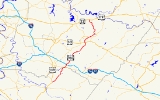
Pennsylvania Route 982 is a state highway
which runs 33 miles across Fayette
and Westmoreland
counties, in southwestern Pennsylvania
. The highway begins at U.S. Route 119
in Moyer, Pennsylvania, and runs northward into Westmoreland County, passing through the towns of Youngstown
, Latrobe
, and Derry
before ending at U.S. Route 22
/U.S. Route 119
near Blairsville
.
near Moyer. From there, it runs northeast across rural Fayette
and Westmoreland
counties, meeting Pennsylvania Route 31
and crossing the Pennsylvania Turnpike
without access. The route intersects Pennsylvania Route 130
about two miles (3 km) southeast of Pleasant Unity, Pennsylvania. The route then passes through Youngstown
, and then meets U.S. Route 30
at a cloverleaf interchange
. The route runs along the eastern end of Latrobe, Pennsylvania
and through McChesneytown
. Route 982 then ends at U.S. Route 22
and U.S. Route 119
near Blairsville
. Before the construction of the Conemaugh Dam, Route 982 used to occupy Livermore Road, across from its current terminus, and continued on, crossing the Conemaugh River at Livermore, Pennsylvania
and connecting with PA 217 a few miles north in Indiana County. Remnants of this section, before Newport Road, can still be seen at the Virginia Farms tract, which is owned by the Army Corp. of Engineers for flood control, and leased to the Game Commission for public use. A small parking spot next to the gate provides easy access, and the remaining surface is well intact, running all the way to the Conemaugh River, at the former site of Fillmore, Pa, on the opposite side from Livermore. This area (Virginia Farms), has a rich history dating back to colonial settlement, and along the former surface, foundations as well as a small bridge crossing a creek can still be seen.
State highway
State highway, state road or state route can refer to one of three related concepts, two of them related to a state or provincial government in a country that is divided into states or provinces :#A...
which runs 33 miles across Fayette
Fayette County, Pennsylvania
Fayette County is a county located in the U.S. state of Pennsylvania. As of the2010 census, the population was 136,606. The county is part of the Pittsburgh Metropolitan Statistical Area....
and Westmoreland
Westmoreland County, Pennsylvania
-Demographics:As of the census of 2000, there were 369,993 people, 149,813 households, and 104,569 families residing in the county. The population density was 361 people per square mile . There were 161,058 housing units at an average density of 157 per square mile...
counties, in southwestern Pennsylvania
Pennsylvania
The Commonwealth of Pennsylvania is a U.S. state that is located in the Northeastern and Mid-Atlantic regions of the United States. The state borders Delaware and Maryland to the south, West Virginia to the southwest, Ohio to the west, New York and Ontario, Canada, to the north, and New Jersey to...
. The highway begins at U.S. Route 119
U.S. Route 119
U.S. Route 119, commonly abbreviated as US 119, is a spur of US 19. It is a north–south route that was an original United States highway of 1926. It is often referred to as Corridor G east of US 23 and KY 80 in Kentucky to Interstate 64 at Charleston, West Virginia.- Kentucky :US 119 is a two...
in Moyer, Pennsylvania, and runs northward into Westmoreland County, passing through the towns of Youngstown
Youngstown, Pennsylvania
Youngstown is a borough in Westmoreland County, Pennsylvania, United States. Youngstown was incorporated on 2 April 1831. The population was 400 at the 2000 census.-History:...
, Latrobe
Latrobe, Pennsylvania
Latrobe is a city in Westmoreland County, Pennsylvania in the United States, approximately southeast of Pittsburgh.The city population was 7,634 as of the 2000 census . It is located near the Pennsylvania's scenic Chestnut Ridge. Latrobe was incorporated as a borough in 1854, and as a city in 1999...
, and Derry
Derry, Pennsylvania
Derry is a borough in Westmoreland County in the Commonwealth of Pennsylvania, east of Pittsburgh. The Borough of Derry, consisting of the town area, should not be confused with Derry Township, which is a separate municipality surrounding the borough. In 1900, the population numbered 2,347, and in...
before ending at U.S. Route 22
U.S. Route 22
U.S. Route 22 is a west–east route and is one of the original United States highways of 1926, running from Cincinnati, Ohio, at US 27, US 42, US 127, and US 52 to Newark, New Jersey, at U.S. Route 1/9 near the Newark Liberty International Airport.US 22 also carries the names of the William...
/U.S. Route 119
U.S. Route 119
U.S. Route 119, commonly abbreviated as US 119, is a spur of US 19. It is a north–south route that was an original United States highway of 1926. It is often referred to as Corridor G east of US 23 and KY 80 in Kentucky to Interstate 64 at Charleston, West Virginia.- Kentucky :US 119 is a two...
near Blairsville
Blairsville, Pennsylvania
-External links:* * *...
.
Route description
Pennsylvania Route 982 begins at U.S. Route 119U.S. Route 119
U.S. Route 119, commonly abbreviated as US 119, is a spur of US 19. It is a north–south route that was an original United States highway of 1926. It is often referred to as Corridor G east of US 23 and KY 80 in Kentucky to Interstate 64 at Charleston, West Virginia.- Kentucky :US 119 is a two...
near Moyer. From there, it runs northeast across rural Fayette
Fayette County, Pennsylvania
Fayette County is a county located in the U.S. state of Pennsylvania. As of the2010 census, the population was 136,606. The county is part of the Pittsburgh Metropolitan Statistical Area....
and Westmoreland
Westmoreland County, Pennsylvania
-Demographics:As of the census of 2000, there were 369,993 people, 149,813 households, and 104,569 families residing in the county. The population density was 361 people per square mile . There were 161,058 housing units at an average density of 157 per square mile...
counties, meeting Pennsylvania Route 31
Pennsylvania Route 31
Pennsylvania Route 31 is a long state highway located in Western Pennsylvania, paralleling U.S. Route 30 and the Pennsylvania Turnpike for most of its length. The designation begins at PA 136 near West Newton and ends at US 30 near Bedford....
and crossing the Pennsylvania Turnpike
Pennsylvania Turnpike
The Pennsylvania Turnpike is a toll highway system operated by the Pennsylvania Turnpike Commission in the Commonwealth of Pennsylvania, United States. The three sections of the turnpike system total . The main section extends from Ohio to New Jersey and is long...
without access. The route intersects Pennsylvania Route 130
Pennsylvania Route 130
Pennsylvania Route 130 is a long state highway located in Allegheny and Westmoreland counties in Pennsylvania. The western terminus is at PA 8 in Pittsburgh. The eastern terminus is at PA 381 near Kregar....
about two miles (3 km) southeast of Pleasant Unity, Pennsylvania. The route then passes through Youngstown
Youngstown, Pennsylvania
Youngstown is a borough in Westmoreland County, Pennsylvania, United States. Youngstown was incorporated on 2 April 1831. The population was 400 at the 2000 census.-History:...
, and then meets U.S. Route 30
U.S. Route 30
U.S. Route 30 is an east–west main route of the system of United States Numbered Highways, with the highway traveling across the northern tier of the country. It is the third longest U.S. route, after U.S. Route 20 and U.S. Route 6. The western end of the highway is at Astoria, Oregon; the...
at a cloverleaf interchange
Cloverleaf interchange
A cloverleaf interchange is a two-level interchange in which left turns, reverse direction in left-driving regions, are handled by ramp roads...
. The route runs along the eastern end of Latrobe, Pennsylvania
Latrobe, Pennsylvania
Latrobe is a city in Westmoreland County, Pennsylvania in the United States, approximately southeast of Pittsburgh.The city population was 7,634 as of the 2000 census . It is located near the Pennsylvania's scenic Chestnut Ridge. Latrobe was incorporated as a borough in 1854, and as a city in 1999...
and through McChesneytown
McChesneytown-Loyalhanna, Pennsylvania
McChesneytown-Loyalhanna is a census-designated place in Westmoreland County, Pennsylvania, United States. The population was 3,415 at the 2000 census.-Geography:McChesneytown-Loyalhanna is located at ....
. Route 982 then ends at U.S. Route 22
U.S. Route 22
U.S. Route 22 is a west–east route and is one of the original United States highways of 1926, running from Cincinnati, Ohio, at US 27, US 42, US 127, and US 52 to Newark, New Jersey, at U.S. Route 1/9 near the Newark Liberty International Airport.US 22 also carries the names of the William...
and U.S. Route 119
U.S. Route 119
U.S. Route 119, commonly abbreviated as US 119, is a spur of US 19. It is a north–south route that was an original United States highway of 1926. It is often referred to as Corridor G east of US 23 and KY 80 in Kentucky to Interstate 64 at Charleston, West Virginia.- Kentucky :US 119 is a two...
near Blairsville
Blairsville, Pennsylvania
-External links:* * *...
. Before the construction of the Conemaugh Dam, Route 982 used to occupy Livermore Road, across from its current terminus, and continued on, crossing the Conemaugh River at Livermore, Pennsylvania
Livermore, Pennsylvania
Livermore, Pennsylvania is an abandoned town that was located on the Conemaugh River between Blairsville and Saltsburg in Derry Township, Westmoreland County, Pennsylvania...
and connecting with PA 217 a few miles north in Indiana County. Remnants of this section, before Newport Road, can still be seen at the Virginia Farms tract, which is owned by the Army Corp. of Engineers for flood control, and leased to the Game Commission for public use. A small parking spot next to the gate provides easy access, and the remaining surface is well intact, running all the way to the Conemaugh River, at the former site of Fillmore, Pa, on the opposite side from Livermore. This area (Virginia Farms), has a rich history dating back to colonial settlement, and along the former surface, foundations as well as a small bridge crossing a creek can still be seen.