

Pennsylvania Route 463
Encyclopedia
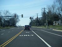
Pennsylvania Route 463 (PA 463) is a 12.9 miles (20.8 km) long route completely in Montgomery County, Pennsylvania
. Its western terminus is at PA 63
(Welsh Road) in Hatfield Township
and its eastern terminus is at PA 611
in Horsham
. It runs through the northern suburban areas of Philadelphia and passes through the towns of Hatfield
, Montgomeryville
, and Horsham
. The route intersects U.S. Route 202
(US 202) and PA 309
in Montgomeryville and PA 152
in Prospectville. Through its length, the route carries the names Forty Foot Road, Cowpath Road, and Horsham Road. PA 463 was designated by 1930 and fully paved by 1940. In 2010, a portion of the route in Montgomery Township
was widened.
on the border of Hatfield Township
and Towamencin Township
, heading northeast on four-lane undivided Forty Foot Road into Hatfield Township. The road passes through commercial areas and narrows to two lanes before it passes a couple farms. The route continues into residential areas with a few businesses and enters the borough of Hatfield
, where it becomes West Broad Street. In Hatfield, the road continues northeast to the center of town. Here, PA 463 turns to the southeast on South Main Street and passes more residential and commercial development, crossing a CSX railroad line. The road crosses back into Hatfield Township becomes Cowpath Road. The route runs through wooded residential neighborhoods before crossing SEPTA's Lansdale/Doylestown Line
near the Fortuna station
and intersecting Broad Street in a commercial area.
Heading back into wooded areas containing homes, PA 463 enters Montgomery Township
at the Line Street intersection. It reaches the community of Montgomeryville
, where PA 463 widens into a four-lane divided highway
and intersects PA 309
(Bethlehem Pike
) and US 202
(Doylestown Road) at the Five Points intersection.
 Past this intersection, the route takes on the name Horsham Road and passes near more businesses as it narrows into a three-lane road with a center left-turn lane and one travel lane in each direction. After crossing North Wales Road, the route carries five lanes total, with two travel lanes in each direction and a center left-turn lane, as it heads into residential areas. The road passes through commercial areas past the Upper State Road intersection and crosses the 202 Parkway, which is under construction. Past Stump Road, PA 463 narrows to two lanes total and runs past a trailer park to the northeast and business parks to the southwest. The route enters more residential surroundings after intersecting Kenas Road, becoming the border between Horsham Township
to the southwest and Montgomery Township to the northeast.
Upon crossing Lower State Road, PA 463 fully enters Horsham Township and becomes a three-lane road with a center left-turn lane as it heads past housing subdivisions. The route loses the turning lane and continues southeast to PA 152
in the village of Prospectville. At this intersection, PA 463 gains a center left-turn lane again and passes a few businesses before continuing past Deep Meadow Park and Kohler Park. The road intersects Keith Valley Road and passes near Samuel Carpenter Park along with development. At the Babylon Road junction, the route becomes a five-lane road and runs past more business parks before coming to Privet Road. At this point, PA 463 runs past the Willow Grove Naval Air Station to the northeast. The road passes near some homes before coming to Norristown Road and passing businesses. The route reaches the edge of the naval air station property at the Maple Avenue intersection and continues past more commercial areas. PA 463 intersects Dresher Road, where the center left-turn lane ends and the road becomes four lanes, reaching its eastern terminus at PA 611
in the community of Horsham
.
in Horsham Township. The remainder of PA 463 was paved by 1940. Also by this time, US 122 became US 202 and PA 463 no longer intersected PA 752, the first of several changes to the routes that intersected PA 463.
By 1970, the US 309 designation that the route intersected in Montgomeryville became PA 309. The route at the eastern terminus of PA 463 changed from US 611 to PA 611 by 1973. Construction began to widen the section of PA 463 between North Wales Road and General Hancock Boulevard into a five-lane road as part of the 202 Parkway project in 2009. The widening project was completed a year later.
Montgomery County, Pennsylvania
Montgomery County is a county located in the U.S. state of Pennsylvania, in the United States. As of 2010, the population was 799,874, making it the third most populous county in Pennsylvania . The county seat is Norristown.The county was created on September 10, 1784, out of land originally part...
. Its western terminus is at PA 63
Pennsylvania Route 63
Pennsylvania Route 63 is a long state highway located in the Philadelphia, Pennsylvania area. The western terminus of the route is at PA 29 in Green Lane, Montgomery County. The eastern terminus is at Interstate 95 in Bensalem Township, Bucks County...
(Welsh Road) in Hatfield Township
Hatfield Township, Pennsylvania
Hatfield Township is a township in Montgomery County, Pennsylvania, United States. The population was 17,249 at the 2010 census.-Geography:According to the United States Census Bureau, the township has a total area of , all of it land. It is in the Delaware watershed and is drained mainly by the...
and its eastern terminus is at PA 611
Pennsylvania Route 611
Pennsylvania Route 611 is a major state highway in Pennsylvania, United States, running from Interstate 95 south of downtown Philadelphia north to Interstate 380 in Coolbaugh Township, Pennsylvania in The Poconos....
in Horsham
Horsham, Pennsylvania
Horsham is a census-designated place in Montgomery County, Pennsylvania, United States. The population was 14,842 at the 2010 census. Horsham is located entirely within Horsham Township, and it is home to Naval Air Station Joint Reserve Base Willow Grove.In 2007, Horsham was named the 15th best...
. It runs through the northern suburban areas of Philadelphia and passes through the towns of Hatfield
Hatfield, Pennsylvania
Hatfield is a borough in Montgomery County, Pennsylvania, United States. The population was 3,290 at the time of the 2010 census.-Geography:Hatfield is located at ....
, Montgomeryville
Montgomeryville, Pennsylvania
Montgomeryville is a census-designated place in Montgomery County, Pennsylvania, United States. The population was 12,624 at the 2010 census....
, and Horsham
Horsham, Pennsylvania
Horsham is a census-designated place in Montgomery County, Pennsylvania, United States. The population was 14,842 at the 2010 census. Horsham is located entirely within Horsham Township, and it is home to Naval Air Station Joint Reserve Base Willow Grove.In 2007, Horsham was named the 15th best...
. The route intersects U.S. Route 202
U.S. Route 202 in Pennsylvania
U.S. Route 202 runs through the southeastern part of the U.S. state of Pennsylvania, passing through the northern and western suburbs of Philadelphia. It follows in a general southwest to northeast direction through the state, passing through West Chester, King of Prussia, Norristown,...
(US 202) and PA 309
Pennsylvania Route 309
Pennsylvania Route 309 is a major highway which runs for 134 miles through Pennsylvania in the United States. It connects Philadelphia and its northern suburbs to Allentown, Hazleton, and Wilkes-Barre. A limited-access highway portion of PA 309 in the Wilkes-Barre area is known as the North...
in Montgomeryville and PA 152
Pennsylvania Route 152
Pennsylvania Route 152 is a 25 mile long state highway located in the US state of Pennsylvania. The route, travels north–south from PA Route 309 located in Cedarbrook north to PA Route 309 located east of Telford.PA 152 is unique to other Pennsylvania Highways because it ends at two...
in Prospectville. Through its length, the route carries the names Forty Foot Road, Cowpath Road, and Horsham Road. PA 463 was designated by 1930 and fully paved by 1940. In 2010, a portion of the route in Montgomery Township
Montgomery Township, Montgomery County, Pennsylvania
Montgomery Township is a township in Montgomery County, Pennsylvania, United States. The population was 24,790 at the 2010 census. It is the location of the Montgomery Mall, a regional shopping mall serving the Route 309 corridor of the Philadelphia suburbs. Much of Montgomery Township's...
was widened.
Route description
PA 463 begins an intersection with PA 63Pennsylvania Route 63
Pennsylvania Route 63 is a long state highway located in the Philadelphia, Pennsylvania area. The western terminus of the route is at PA 29 in Green Lane, Montgomery County. The eastern terminus is at Interstate 95 in Bensalem Township, Bucks County...
on the border of Hatfield Township
Hatfield Township, Pennsylvania
Hatfield Township is a township in Montgomery County, Pennsylvania, United States. The population was 17,249 at the 2010 census.-Geography:According to the United States Census Bureau, the township has a total area of , all of it land. It is in the Delaware watershed and is drained mainly by the...
and Towamencin Township
Towamencin Township, Pennsylvania
Towamencin Township is a township in Montgomery County, Pennsylvania, United States. The population was 17,578 at the 2010 census. It is part of the North Penn School District. Towamencin has residential neighborhoods, historic farmhouses, recreational facilities, many schools, and open spaces. ...
, heading northeast on four-lane undivided Forty Foot Road into Hatfield Township. The road passes through commercial areas and narrows to two lanes before it passes a couple farms. The route continues into residential areas with a few businesses and enters the borough of Hatfield
Hatfield, Pennsylvania
Hatfield is a borough in Montgomery County, Pennsylvania, United States. The population was 3,290 at the time of the 2010 census.-Geography:Hatfield is located at ....
, where it becomes West Broad Street. In Hatfield, the road continues northeast to the center of town. Here, PA 463 turns to the southeast on South Main Street and passes more residential and commercial development, crossing a CSX railroad line. The road crosses back into Hatfield Township becomes Cowpath Road. The route runs through wooded residential neighborhoods before crossing SEPTA's Lansdale/Doylestown Line
Lansdale/Doylestown Line
The Lansdale/Doylestown Line is a SEPTA Regional Rail line connecting Center City Philadelphia to Doylestown in Bucks County.-Route:The Lansdale-Doylestown segment of the R5 line utilizes what is known as the "SEPTA Main Line", a four-track line that has been owned by SEPTA since 1983...
near the Fortuna station
Fortuna (SEPTA station)
Fortuna is a station along the SEPTA Lansdale/Doylestown Line. It is located near the corner of North Broad Street and Cowpath Road in Hatfield Pennsylvania, United States. Cowpath Road was originally an actual cow path. The station was named after a cow that was killed at the crossing.-External...
and intersecting Broad Street in a commercial area.
Heading back into wooded areas containing homes, PA 463 enters Montgomery Township
Montgomery Township, Montgomery County, Pennsylvania
Montgomery Township is a township in Montgomery County, Pennsylvania, United States. The population was 24,790 at the 2010 census. It is the location of the Montgomery Mall, a regional shopping mall serving the Route 309 corridor of the Philadelphia suburbs. Much of Montgomery Township's...
at the Line Street intersection. It reaches the community of Montgomeryville
Montgomeryville, Pennsylvania
Montgomeryville is a census-designated place in Montgomery County, Pennsylvania, United States. The population was 12,624 at the 2010 census....
, where PA 463 widens into a four-lane divided highway
Divided Highway
Divided Highway is a compilation album by American rock band The Doobie Brothers, released in 2003. . All tracks are taken from the albums Cycles and Brotherhood .-Track listing:...
and intersects PA 309
Pennsylvania Route 309
Pennsylvania Route 309 is a major highway which runs for 134 miles through Pennsylvania in the United States. It connects Philadelphia and its northern suburbs to Allentown, Hazleton, and Wilkes-Barre. A limited-access highway portion of PA 309 in the Wilkes-Barre area is known as the North...
(Bethlehem Pike
Bethlehem Pike
Bethlehem Pike is a historic 41 mi long road in the U.S. state of Pennsylvania, connecting Philadelphia and Bethlehem, Pennsylvania. It began as a Native American path called the Minsi Trail which evolved into a colonial highway called the King's Road in the 1760s. Most of the route...
) and US 202
U.S. Route 202 in Pennsylvania
U.S. Route 202 runs through the southeastern part of the U.S. state of Pennsylvania, passing through the northern and western suburbs of Philadelphia. It follows in a general southwest to northeast direction through the state, passing through West Chester, King of Prussia, Norristown,...
(Doylestown Road) at the Five Points intersection.
Horsham Township, Pennsylvania
Horsham Township is a home rule municipality in Montgomery County, Pennsylvania, United States. Although it retains the word "Township" in its official name, it has been governed by a home rule charter since 1975 and is therefore not subject to the Pennsylvania Township Code...
to the southwest and Montgomery Township to the northeast.
Upon crossing Lower State Road, PA 463 fully enters Horsham Township and becomes a three-lane road with a center left-turn lane as it heads past housing subdivisions. The route loses the turning lane and continues southeast to PA 152
Pennsylvania Route 152
Pennsylvania Route 152 is a 25 mile long state highway located in the US state of Pennsylvania. The route, travels north–south from PA Route 309 located in Cedarbrook north to PA Route 309 located east of Telford.PA 152 is unique to other Pennsylvania Highways because it ends at two...
in the village of Prospectville. At this intersection, PA 463 gains a center left-turn lane again and passes a few businesses before continuing past Deep Meadow Park and Kohler Park. The road intersects Keith Valley Road and passes near Samuel Carpenter Park along with development. At the Babylon Road junction, the route becomes a five-lane road and runs past more business parks before coming to Privet Road. At this point, PA 463 runs past the Willow Grove Naval Air Station to the northeast. The road passes near some homes before coming to Norristown Road and passing businesses. The route reaches the edge of the naval air station property at the Maple Avenue intersection and continues past more commercial areas. PA 463 intersects Dresher Road, where the center left-turn lane ends and the road becomes four lanes, reaching its eastern terminus at PA 611
Pennsylvania Route 611
Pennsylvania Route 611 is a major state highway in Pennsylvania, United States, running from Interstate 95 south of downtown Philadelphia north to Interstate 380 in Coolbaugh Township, Pennsylvania in The Poconos....
in the community of Horsham
Horsham, Pennsylvania
Horsham is a census-designated place in Montgomery County, Pennsylvania, United States. The population was 14,842 at the 2010 census. Horsham is located entirely within Horsham Township, and it is home to Naval Air Station Joint Reserve Base Willow Grove.In 2007, Horsham was named the 15th best...
.
History
When Pennsylvania first legislated routes in 1911, present-day PA 463 was not given a number. By 1930, PA 463 was designated onto its current alignment from PA 63 in Hatfield Township to US 611 in Horsham. At this time, the route was paved between PA 63 and Hatfield and within Horsham Township. When first created, PA 463 intersected US 122/US 309 in Montgomery Township, and PA 152 and PA 752Pennsylvania Route 752
Pennsylvania Route 752 was a state highway located in Montgomery County, Pennsylvania. The route connected PA 63 to US 611 in Horsham between 1930 and 1940. The route is today known as Dresher Road.-Route description:...
in Horsham Township. The remainder of PA 463 was paved by 1940. Also by this time, US 122 became US 202 and PA 463 no longer intersected PA 752, the first of several changes to the routes that intersected PA 463.
By 1970, the US 309 designation that the route intersected in Montgomeryville became PA 309. The route at the eastern terminus of PA 463 changed from US 611 to PA 611 by 1973. Construction began to widen the section of PA 463 between North Wales Road and General Hancock Boulevard into a five-lane road as part of the 202 Parkway project in 2009. The widening project was completed a year later.