
Pemigewasset Wilderness
Encyclopedia
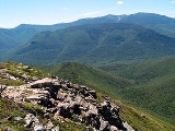
The Pemigewasset Wilderness is a 45000 acres (182 km²) federally-designated Wilderness Area
in the heart of New Hampshire
's White Mountains
. It is a part of the White Mountain National Forest
.
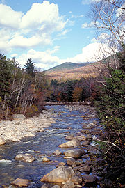
The Wilderness Area consists of the upper watershed of the East Branch of the Pemigewasset River
, and includes the Franconia
, Twin
, Zealand
, and Hancock
mountain ranges, but excludes the summits of the ranges and the trail along them. As a result of the region's rugged character, the Pemigewasset Wilderness is a popular recreation area; its large trail network receives heavy use, in the form of hiking
, cross-country skiing
, and others, throughout the year.
The area is also noted for its ecological recovery from the logging
era of the late nineteenth and early twentieth centuries. After years of unchecked clear-cutting, the area's inclusion in the White Mountain National Forest
and later designation as a Wilderness Area has led to a substantial rebound in the forest ecosystem.
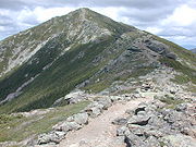 The western lobe is enclosed by the Franconia, Twin, and Bond ranges, though the top of the ridge defining the ranges is outside the Wilderness boundary. Moving clockwise from the south near the Lincoln Woods trailhead, the ridge ascends Potash Knob (2684 ft/818 m), an unnamed peak (3060 ft/933 m), and Whaleback Mountain (2586 ft/1093 m) before reaching Franconia Ridge itself at the ledgy summit of Mount Flume
(4328 ft/1319 m). From Mount Flume, the ridge dips and rises between peaks in a parabolic manner, flirting with treeline in the cols and running open and exposed at the summits. Peaks crossed at this point of the ridge after Flume include Mount Liberty
(4459 ft/1359 m), and Little Haystack Mountain (4780 ft/1457 m), where the ridge rises out of the scrub for good. As it heads north, the ridge assumes a "knife-edge" character, dropping off dramatically on both sides as it crosses Mount Lincoln
(5089 ft/1551 m) before reaching its high point at the summit of Mount Lafayette (5249 ft/1600).
 From the summit of Lafayette, the ridge, thence known as Garfield Ridge, makes its way toward the Twin Range
. It passes over a small subsidiary peak of Lafayette before descending abruptly into the scrub below timberline; after several small knobs, the summits of Garfield
(4500 ft/1372 m) and Galehead
(4024 ft/1227 m) mountains are crossed, and the ridge breaks into the open and begins a steep climb to the summit of South Twin Mountain
(4902 ft/1494 m). As a spur ridge extends north to North Twin Mountain
(4761 ft/1451 m), the main ridge makes a southward turn and runs in the open to the summit of Mount Guyot
(4580 ft/1396 m). Enclosing the western lobe, the Bond Range extends south from Guyot, passing over Mount Bond
(4698 ft/1432 m) and Bondcliff (4265 ft/1300 m) before descending sharply into the woods to the East Branch of the Pemigewasset
.
In the center of the western lobe is the long, broad ridge of Owl's Head
(4025 ft/1227 m), which rises abruptly from the valley of Lincoln Brook and extends north for roughly 3 miles (4.8 km) to a low saddle connecting it to Garfield Ridge. Almost completely encircling Owl's Head are two tributaries of the East Branch, Lincoln Brook and Franconia Branch; Lincoln Brook drains the east face of Franconia Ridge, while Franconia Branch drains the southern and western faces of the Twin and Bond Ranges through Twin, Redrock, and Hellgate Brooks.
From Mount Guyot, the eastern lobe's main ridge continues east rather than following the Bond Range to the south. Passing over Zealand Mountain (4260 ft/1298 m) and a small knob known as Zeacliff Pond Peak (4060 ft/1237 m), the ridge reaches an abrupt end at Zeacliff, a dramatic overlook into Zealand Notch
. From Zeacliff, the Wilderness Boundary plunges into the notch following the Twinway trail, and follows the Ethan Pond Trail into the flatter sections of the lobe. After a few miles, the boundary picks up the ridge of Mount Lowell, and runs over Mount Nancy
(3926 ft/1197 m), Mount Anderson (3740 ft/1140 m), and near the summit of Lowell itself (3740 ft/1140 m) before crossing Carrigain Notch and rising to Vose Spur (3862 ft/1177 m) and the summit of Mount Carrigain
(4700 ft/1433 m). Confined to a more obvious ridge at this point, the boundary passes over The Captain (3540 ft/1079 m) and the main summit of Mount Hancock
(4420 ft/1347 m) before descending to the East Branch across from Bondcliff via Mount Hitchcock (3620 ft/1103 m) and its several small knobs. Note that the boundary as implemented excludes the Appalachian Trail and the summits it passes over as well as Mount Carrigain.
The East Branch of the Pemigewasset drains the eastern lobe through a number of small streams. Mounts Hancock and Carrigain are drained by Crystal, Carrigain, and Notch Brooks, while the center drains to the North Fork of the Pemigewasset
and Shoal Pond Brook.
schist
s and gneiss
es formed during the Acadian Orogeny
, the Pemigewasset Wilderness is part of the White Mountain Batholith
and is therefore composed primarily of the igneous White Mountain plutonic-volcanic rock
series.
The Franconia and Twin Ranges form a massive ring dike
in the western half of the White Mountain Batholith made up of a granite
porphyry
backbone that emerged roughly 170 million years ago. This rock appears pink, red, green or grey, with medium-sized phenocryst
s. Such phenocrysts, usually quartz
or feldspar
, make up 20%-40% of the rock, and are embedded in a groundmass of similar composition. Enclosed by the ring dike and extending in to the flat floor of the wilderness is a large area of biotite
and amphibole
granite.
National Wilderness Preservation System
The National Wilderness Preservation System of the United States protects federally managed land areas designated for preservation in their natural condition. It was established by the Wilderness Act upon the signature of President Lyndon B. Johnson on September 3, 1964...
in the heart of New Hampshire
New Hampshire
New Hampshire is a state in the New England region of the northeastern United States of America. The state was named after the southern English county of Hampshire. It is bordered by Massachusetts to the south, Vermont to the west, Maine and the Atlantic Ocean to the east, and the Canadian...
's White Mountains
White Mountains (New Hampshire)
The White Mountains are a mountain range covering about a quarter of the state of New Hampshire and a small portion of western Maine in the United States. Part of the Appalachian Mountains, they are considered the most rugged mountains in New England...
. It is a part of the White Mountain National Forest
White Mountain National Forest
The White Mountain National Forest is a federally-managed forest contained within the White Mountains in the northeastern United States. It was established in 1918 as a result of the Weeks Act of 1911; federal acquisition of land had already begun in 1914. It has a total area of...
.
The Wilderness Area consists of the upper watershed of the East Branch of the Pemigewasset River
East Branch Pemigewasset River
The East Branch of the Pemigewasset River is a river located in the White Mountains of New Hampshire in the United States. It is a tributary of the Pemigewasset River, part of the Merrimack River watershed....
, and includes the Franconia
Franconia Range
The Franconia Range is a mountain range located in the White Mountains of the U.S. state of New Hampshire. It is the second-highest range of peaks in the White Mountains....
, Twin
Twin Range
The Twin Range is a mountain range within the White Mountains of New Hampshire.- Summits :Notable peaks within the range include North Twin Mountain, South Twin Mountain, Mount Guyot, Mount Bond, Mount Garfield, Zealand Mountain, and Mount Hale....
, Zealand
Mount Zealand
Mount Zealand, or Zealand Mountain, is a mountain located in the White Mountains, in Grafton County, New Hampshire. Zealand stands on a spur ridge northeast of Mount Guyot, and facing Whitewall Mountain to the east across Zealand Notch....
, and Hancock
Mount Hancock (New Hampshire)
Mount Hancock is a mountain located in Grafton County, New Hampshire, named after John Hancock , one of the Founding Fathers of the United States....
mountain ranges, but excludes the summits of the ranges and the trail along them. As a result of the region's rugged character, the Pemigewasset Wilderness is a popular recreation area; its large trail network receives heavy use, in the form of hiking
Hiking
Hiking is an outdoor activity which consists of walking in natural environments, often in mountainous or other scenic terrain. People often hike on hiking trails. It is such a popular activity that there are numerous hiking organizations worldwide. The health benefits of different types of hiking...
, cross-country skiing
Cross-country skiing
Cross-country skiing is a winter sport in which participants propel themselves across snow-covered terrain using skis and poles...
, and others, throughout the year.
The area is also noted for its ecological recovery from the logging
Logging
Logging is the cutting, skidding, on-site processing, and loading of trees or logs onto trucks.In forestry, the term logging is sometimes used in a narrow sense concerning the logistics of moving wood from the stump to somewhere outside the forest, usually a sawmill or a lumber yard...
era of the late nineteenth and early twentieth centuries. After years of unchecked clear-cutting, the area's inclusion in the White Mountain National Forest
White Mountain National Forest
The White Mountain National Forest is a federally-managed forest contained within the White Mountains in the northeastern United States. It was established in 1918 as a result of the Weeks Act of 1911; federal acquisition of land had already begun in 1914. It has a total area of...
and later designation as a Wilderness Area has led to a substantial rebound in the forest ecosystem.
Geography
The Pemigewasset Wilderness consists of two horseshoe-shaped "lobes" characterized by relatively low, wet river valleys surrounded by high mountain ridges.Western lobe
Mount Flume
Mount Flume is a peak in the White Mountains overlooking Franconia Notch. It is tall and is accessible from the north by the Franconia Ridge Trail, from the southeast by the Osseo Trail, and from the west by the Flume Slide Trail to the Franconia Ridge Trail....
(4328 ft/1319 m). From Mount Flume, the ridge dips and rises between peaks in a parabolic manner, flirting with treeline in the cols and running open and exposed at the summits. Peaks crossed at this point of the ridge after Flume include Mount Liberty
Mount Liberty (New Hampshire)
Mount Liberty is a high mountain in the White Mountains of New Hampshire. It is part of Franconia Ridge, a minor mountain range overlooking Franconia Notch, whose highest summit is Mount Lafayette....
(4459 ft/1359 m), and Little Haystack Mountain (4780 ft/1457 m), where the ridge rises out of the scrub for good. As it heads north, the ridge assumes a "knife-edge" character, dropping off dramatically on both sides as it crosses Mount Lincoln
Mount Lincoln (New Hampshire)
Mount Lincoln is a 5,089-foot-high mountain within the Franconia Range of the White Mountains of New Hampshire. Lincoln is located between Little Haystack and Mount Lafayette. All three overlook Franconia Notch. The west side of Lincoln drains into the main stem of the Pemigewasset River...
(5089 ft/1551 m) before reaching its high point at the summit of Mount Lafayette (5249 ft/1600).
Twin Range
The Twin Range is a mountain range within the White Mountains of New Hampshire.- Summits :Notable peaks within the range include North Twin Mountain, South Twin Mountain, Mount Guyot, Mount Bond, Mount Garfield, Zealand Mountain, and Mount Hale....
. It passes over a small subsidiary peak of Lafayette before descending abruptly into the scrub below timberline; after several small knobs, the summits of Garfield
Mount Garfield (New Hampshire)
Mount Garfield is a mountain located in Grafton County, New Hampshire. The mountain is part of the White Mountains. Mt. Garfield is flanked to the east by South Twin Mountain, and to the southwest along Garfield Ridge by Mount Lafayette....
(4500 ft/1372 m) and Galehead
Galehead Mountain
Galehead Mountain is a mountain located in Grafton County, New Hampshire. The mountain is part of the Twin Range of the White Mountains.Galehead is flanked to the east by South Twin Mountain, and to the west by Mount Garfield....
(4024 ft/1227 m) mountains are crossed, and the ridge breaks into the open and begins a steep climb to the summit of South Twin Mountain
South Twin Mountain (New Hampshire)
South Twin Mountain is a mountain located in Grafton County, New Hampshire. The mountain is part of the Twin Range of the White Mountains. South Twin forms the high point of a north-south ridge, with North Twin Mountain lying approximately one mile to the north and Mount Guyot two miles to the...
(4902 ft/1494 m). As a spur ridge extends north to North Twin Mountain
North Twin Mountain (New Hampshire)
North Twin Mountain is a mountain located in Grafton County, New Hampshire. The mountain forms the north end of the Twin Range of the White Mountains. North Twin overlooks the village of Twin Mountain, lying to the north of the mountain at the intersection of US Routes 3 and 302...
(4761 ft/1451 m), the main ridge makes a southward turn and runs in the open to the summit of Mount Guyot
Mount Guyot (New Hampshire)
Mount Guyot is a mountain located in Grafton County, New Hampshire. The mountain is named after Professor Arnold H. Guyot of Princeton University, and is part of the Twin Range of the White Mountains....
(4580 ft/1396 m). Enclosing the western lobe, the Bond Range extends south from Guyot, passing over Mount Bond
Mount Bond
Mount Bond is a mountain located in Grafton County, New Hampshire, United States. The mountain is named after Professor George P. Bond of Harvard University, and is the southernmost extension of the Twin Range of the White Mountains. Mount Bond is flanked to the north by Mount Guyot.Mount Bond...
(4698 ft/1432 m) and Bondcliff (4265 ft/1300 m) before descending sharply into the woods to the East Branch of the Pemigewasset
East Branch Pemigewasset River
The East Branch of the Pemigewasset River is a river located in the White Mountains of New Hampshire in the United States. It is a tributary of the Pemigewasset River, part of the Merrimack River watershed....
.
In the center of the western lobe is the long, broad ridge of Owl's Head
Owl's Head (Franconia)
Owl's Head is a mountain in Franconia, New Hampshire. It lies between the Franconia Branch of the Pemigewasset River and Lincoln Brook , in the Pemigewasset Wilderness of the White Mountain National Forest....
(4025 ft/1227 m), which rises abruptly from the valley of Lincoln Brook and extends north for roughly 3 miles (4.8 km) to a low saddle connecting it to Garfield Ridge. Almost completely encircling Owl's Head are two tributaries of the East Branch, Lincoln Brook and Franconia Branch; Lincoln Brook drains the east face of Franconia Ridge, while Franconia Branch drains the southern and western faces of the Twin and Bond Ranges through Twin, Redrock, and Hellgate Brooks.
Eastern lobe
The eastern lobe of the Pemigewasset Wilderness is flatter than the west and also far more poorly defined. The "boundary wall" formed in the west by the Franconia, Twin, and Bond Ranges is present in the eastern lobe to a degree, but is less obvious and often extends outside the boundary of the official Wilderness designation.From Mount Guyot, the eastern lobe's main ridge continues east rather than following the Bond Range to the south. Passing over Zealand Mountain (4260 ft/1298 m) and a small knob known as Zeacliff Pond Peak (4060 ft/1237 m), the ridge reaches an abrupt end at Zeacliff, a dramatic overlook into Zealand Notch
Zealand Notch
Zealand Notch is a mountain pass located in the White Mountains of New Hampshire, United States. It is located in the towns of Bethlehem and Lincoln, near the northeastern corner of the Pemigewasset Wilderness. The center of the notch is traversed by hiking trails and is located approximately 2...
. From Zeacliff, the Wilderness Boundary plunges into the notch following the Twinway trail, and follows the Ethan Pond Trail into the flatter sections of the lobe. After a few miles, the boundary picks up the ridge of Mount Lowell, and runs over Mount Nancy
Mount Nancy
Mount Nancy, formerly Mount Amorisgelu, is a mountain located in Grafton County, New Hampshire, on the eastern boundary of the Pemigewasset Wilderness of the White Mountains. The mountain is the highest point and namesake of the Nancy Range....
(3926 ft/1197 m), Mount Anderson (3740 ft/1140 m), and near the summit of Lowell itself (3740 ft/1140 m) before crossing Carrigain Notch and rising to Vose Spur (3862 ft/1177 m) and the summit of Mount Carrigain
Mount Carrigain
Mount Carrigain is a mountain located in Grafton County, New Hampshire. The mountain is named after Phillip Carrigain, NH Secretary of State , and is on the south side of the Pemigewasset Wilderness, the source of the East Branch of the Pemigewasset River in the heart of the White Mountains,...
(4700 ft/1433 m). Confined to a more obvious ridge at this point, the boundary passes over The Captain (3540 ft/1079 m) and the main summit of Mount Hancock
Mount Hancock (New Hampshire)
Mount Hancock is a mountain located in Grafton County, New Hampshire, named after John Hancock , one of the Founding Fathers of the United States....
(4420 ft/1347 m) before descending to the East Branch across from Bondcliff via Mount Hitchcock (3620 ft/1103 m) and its several small knobs. Note that the boundary as implemented excludes the Appalachian Trail and the summits it passes over as well as Mount Carrigain.
The East Branch of the Pemigewasset drains the eastern lobe through a number of small streams. Mounts Hancock and Carrigain are drained by Crystal, Carrigain, and Notch Brooks, while the center drains to the North Fork of the Pemigewasset
North Fork Pemigewasset River
The North Fork of the East Branch of the Pemigewasset River is a river located in the White Mountains of New Hampshire in the United States. It is a tributary of the East Branch of the Pemigewasset River, part of the Merrimack River watershed....
and Shoal Pond Brook.
Geology
While most of the White Mountains consist of highly metamorphicizedMetamorphic rock
Metamorphic rock is the transformation of an existing rock type, the protolith, in a process called metamorphism, which means "change in form". The protolith is subjected to heat and pressure causing profound physical and/or chemical change...
schist
Schist
The schists constitute a group of medium-grade metamorphic rocks, chiefly notable for the preponderance of lamellar minerals such as micas, chlorite, talc, hornblende, graphite, and others. Quartz often occurs in drawn-out grains to such an extent that a particular form called quartz schist is...
s and gneiss
Gneiss
Gneiss is a common and widely distributed type of rock formed by high-grade regional metamorphic processes from pre-existing formations that were originally either igneous or sedimentary rocks.-Etymology:...
es formed during the Acadian Orogeny
Acadian orogeny
The Taconic, Acadian and Alleghenian orogenies are the three tectonic phases responsible for the formation of the present Appalachian Mountains. The Acadian orogeny is a middle Paleozoic mountain building episode dating back 325-400 million years which should not be regarded as a single event but...
, the Pemigewasset Wilderness is part of the White Mountain Batholith
Batholith
A batholith is a large emplacement of igneous intrusive rock that forms from cooled magma deep in the Earth's crust...
and is therefore composed primarily of the igneous White Mountain plutonic-volcanic rock
Rock (geology)
In geology, rock or stone is a naturally occurring solid aggregate of minerals and/or mineraloids.The Earth's outer solid layer, the lithosphere, is made of rock. In general rocks are of three types, namely, igneous, sedimentary, and metamorphic...
series.
The Franconia and Twin Ranges form a massive ring dike
Ring dike
A ring dike or ring dyke in geology refers to an intrusive igneous body. Their chemistry, petrology and field appearance precisely match those of dikes or sill, but their concentric or radial geometric distribution around a centre of volcanic activity indicates their subvolcanic origins.-Notable...
in the western half of the White Mountain Batholith made up of a granite
Granite
Granite is a common and widely occurring type of intrusive, felsic, igneous rock. Granite usually has a medium- to coarse-grained texture. Occasionally some individual crystals are larger than the groundmass, in which case the texture is known as porphyritic. A granitic rock with a porphyritic...
porphyry
Porphyry (geology)
Porphyry is a variety of igneous rock consisting of large-grained crystals, such as feldspar or quartz, dispersed in a fine-grained feldspathic matrix or groundmass. The larger crystals are called phenocrysts...
backbone that emerged roughly 170 million years ago. This rock appears pink, red, green or grey, with medium-sized phenocryst
Phenocryst
thumb|right|300px|[[Granite]]s often have large [[feldspar|feldspatic]] phenocrysts. This granite, from the [[Switzerland|Swiss]] side of the [[Mont Blanc]] massif, has large white [[plagioclase]] phenocrysts, [[triclinic]] [[mineral]]s that give [[trapezium|trapezoid]] shapes when cut through)...
s. Such phenocrysts, usually quartz
Quartz
Quartz is the second-most-abundant mineral in the Earth's continental crust, after feldspar. It is made up of a continuous framework of SiO4 silicon–oxygen tetrahedra, with each oxygen being shared between two tetrahedra, giving an overall formula SiO2. There are many different varieties of quartz,...
or feldspar
Feldspar
Feldspars are a group of rock-forming tectosilicate minerals which make up as much as 60% of the Earth's crust....
, make up 20%-40% of the rock, and are embedded in a groundmass of similar composition. Enclosed by the ring dike and extending in to the flat floor of the wilderness is a large area of biotite
Biotite
Biotite is a common phyllosilicate mineral within the mica group, with the approximate chemical formula . More generally, it refers to the dark mica series, primarily a solid-solution series between the iron-endmember annite, and the magnesium-endmember phlogopite; more aluminous endmembers...
and amphibole
Amphibole
Amphibole is the name of an important group of generally dark-colored rock-forming inosilicate minerals, composed of double chain tetrahedra, linked at the vertices and generally containing ions of iron and/or magnesium in their structures.-Mineralogy:...
granite.
External links
- Pemigewasset Wilderness - Wilderness.net
- Roadless Area Profiles - USDA Forest Service