

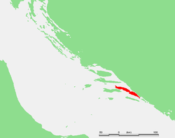
Pelješac
Encyclopedia
Chakavian dialect
Chakavian or Čakavian is a dialect of the Croatian language. The name stems from the word for "what?", which is "ča" in Čakavian...
: Pelišac; ) is a peninsula
Peninsula
A peninsula is a piece of land that is bordered by water on three sides but connected to mainland. In many Germanic and Celtic languages and also in Baltic, Slavic and Hungarian, peninsulas are called "half-islands"....
in southern Dalmatia
Dalmatia
Dalmatia is a historical region on the eastern coast of the Adriatic Sea. It stretches from the island of Rab in the northwest to the Bay of Kotor in the southeast. The hinterland, the Dalmatian Zagora, ranges from fifty kilometers in width in the north to just a few kilometers in the south....
in Croatia
Croatia
Croatia , officially the Republic of Croatia , is a unitary democratic parliamentary republic in Europe at the crossroads of the Mitteleuropa, the Balkans, and the Mediterranean. Its capital and largest city is Zagreb. The country is divided into 20 counties and the city of Zagreb. Croatia covers ...
. The peninsula is part of the Dubrovnik-Neretva County
Dubrovnik-Neretva County
The Dubrovnik–Neretva County is the southernmost Croatian county located in south Dalmatia. The county seat is Dubrovnik and other large towns are Korčula, Metković, Opuzen and Ploče...
and is the second largest peninsula in Croatia. From the isthmus that begins at Ston
Ston
Ston is a village and municipality in the Dubrovnik-Neretva County of Croatia, located at the south of isthmus of the Pelješac peninsula. The town of Ston is the center of the Ston municipality.- Demographics :...
, to the top of Cape Lovišta
Lovište
Lovište is small port town located in the Dubrovnik-Neretva county in Croatia. It has a population of 244. It is situated at the very end of the Pelješac peninsula, and was isolated before a road to the town was built....
, it is 65 km long.
Etymology
The name Pelješac is most likely derived from the name of a hill above town of OrebićOrebic
Orebić is a port town and municipality in the Dubrovnik-Neretva county in Croatia. It is located on the Pelješac peninsula on the Dalmatian coast. Orebić is directly across a strait from the town of Korčula, located on the island of the same name. Ferries service the two towns frequently...
, which is Pelisac. This is a relatively new name for the peninsula. Throughout history other names have been used such as Stonski Rat, Puncta Stagni, Ponta di Stagno and Sabioncello.
Geography
The Bay of Mali StonBay of Mali Ston
Bay of Mali Ston is a bay in the Adriatic Sea. The bay is located in Croatia's and partly in Bosnia and Herzegovina's territorial waters.The maritime boundary between the two countries is an equidistant line between the Pelješac peninsula of Croatia in the southwest and the Klek peninsula of...
separates the peninsula from the Klek peninsula of Bosnia and Herzegovina
Bosnia and Herzegovina
Bosnia and Herzegovina , sometimes called Bosnia-Herzegovina or simply Bosnia, is a country in Southern Europe, on the Balkan Peninsula. Bordered by Croatia to the north, west and south, Serbia to the east, and Montenegro to the southeast, Bosnia and Herzegovina is almost landlocked, except for the...
and from the Croatian "mainland". The Strait of Pelješac is located at its far western end, and it divides the peninsula from the island of Korčula
Korcula
Korčula is an island in the Adriatic Sea, in the Dubrovnik-Neretva County of Croatia. The island has an area of ; long and on average wide — and lies just off the Dalmatian coast. Its 16,182 inhabitants make it the second most populous Adriatic island after Krk...
.
Municipalities
Administratively the peninsula is divided into the municipalities of:- OrebićOrebicOrebić is a port town and municipality in the Dubrovnik-Neretva county in Croatia. It is located on the Pelješac peninsula on the Dalmatian coast. Orebić is directly across a strait from the town of Korčula, located on the island of the same name. Ferries service the two towns frequently...
in the western part, with 4,165 inhabitants (2001) - TrpanjTrpanjTrpanj , is a town and municipality of Dubrovnik-Neretva County in south-eastern Croatia. According to the 2001 census, Trpanj has a population of 871. Croats make up 93.11% of the population.-Etymology:...
in the northwest, with 871 people - Janjina in the center, 593 people
- StonStonSton is a village and municipality in the Dubrovnik-Neretva County of Croatia, located at the south of isthmus of the Pelješac peninsula. The town of Ston is the center of the Ston municipality.- Demographics :...
in the east, with 2,605 residents
History
The earliest known historic records of Peljesac are from ancient GreeceGreece
Greece , officially the Hellenic Republic , and historically Hellas or the Republic of Greece in English, is a country in southeastern Europe....
.The area became part of the Roman
Ancient Rome
Ancient Rome was a thriving civilization that grew on the Italian Peninsula as early as the 8th century BC. Located along the Mediterranean Sea and centered on the city of Rome, it expanded to one of the largest empires in the ancient world....
province of Dalmatia
Dalmatia
Dalmatia is a historical region on the eastern coast of the Adriatic Sea. It stretches from the island of Rab in the northwest to the Bay of Kotor in the southeast. The hinterland, the Dalmatian Zagora, ranges from fifty kilometers in width in the north to just a few kilometers in the south....
after the Illyrian Wars
Illyrian Wars
Illyrian Wars were a set of conflicts of 229 BC, 219 BC and 168 BC when Rome overran the Illyrian settlements and suppressed the piracy that had made the Adriatic unsafe for Italian commerce. There were three campaigns, the first against Teuta, the second against Demetrius of Pharos and the third...
(220 BC
220 BC
Year 220 BC was a year of the pre-Julian Roman calendar. At the time it was known as the Year of the Consulship of Laevinus/Catulus and Scaevola/Philo...
to 219 BC.). Roman migration soon followed. In the 6th century Peljesac came under Byzantine
Byzantine
Byzantine usually refers to the Roman Empire during the Middle Ages.Byzantine may also refer to:* A citizen of the Byzantine Empire, or native Greek during the Middle Ages...
rule.
The Great Migrations of the 6th and 7th centuries, brought the Slavic invasions and Avar into this region. As the barbarians began settling on the coast, the Romanised local coastal population had to take refuge on the islands. Along the Dalmatian coast the Slavic peoples migrations poured in from the interior and seized control of the area where the Neretva River enters the Adriatic, to the Bay of Kotor
Bay of Kotor
The Bay of Kotor in south-western Montenegro is a winding bay on the Adriatic Sea. The bay, sometimes called Europe's southernmost fjord, is in fact a submerged river canyon of the disintegrated Bokelj River which used to run from the high mountain plateaus of Mount Orjen...
. The Slavs settled on the peninsula.
The eastern part of the peninsula was part of a medieval Slavic duchy of Hum or Zachlumia
Zachlumia
Zachlumia or Zahumlje was a medieval principality located in modern-day regions of Herzegovina and southern Dalmatia...
, the control over which changed hands numerous times before 1333 when as a result of a war, the Republic of Ragusa
Republic of Ragusa
The Republic of Ragusa or Republic of Dubrovnik was a maritime republic centered on the city of Dubrovnik in Dalmatia , that existed from 1358 to 1808...
bought the entire peninsula from the Serbian Empire
Serbian Empire
The Serbian Empire was a short-lived medieval empire in the Balkans that emerged from the Serbian Kingdom. Stephen Uroš IV Dušan was crowned Emperor of Serbs and Greeks on 16 April, 1346, a title signifying a successorship to the Eastern Roman Empire...
of Tsar Dušan
Dušan
Dušan is a Slavic name predominantly used by Serbs, Montenegrins, Czechs, Slovaks and Slovenes. Its meaning is soul, spirit. Ethymologically it derives from the name 'spirit', first used by Stephen Uroš IV Dušan of Serbia in the 14th century...
.
The Walls of Ston
Walls of Ston
The Walls of Ston are a series of defensive stone walls, originally more than long, that surrounded and protected the city of Ston, in Dalmatia, part of the Republic of Ragusa, in what is now southern Croatia....
are large fortifications built by the Republic of Ragusa
Republic of Ragusa
The Republic of Ragusa or Republic of Dubrovnik was a maritime republic centered on the city of Dubrovnik in Dalmatia , that existed from 1358 to 1808...
(Dubrovnik). They are the second longest walls in Europe. Ston also has one of the oldest salt planes in this part of the world.
The French Empire
First French Empire
The First French Empire , also known as the Greater French Empire or Napoleonic Empire, was the empire of Napoleon I of France...
occupied the region in 1806, abolishing the old Republic, and in 1808 turned it into the Illyrian Provinces
Illyrian provinces
The Illyrian Provinces was an autonomous province of the Napoleonic French Empire on the north and east coasts of the Adriatic Sea between 1809 and 1816. Its capital was established at Laybach...
. In 1815 it was given to the Austrian Empire
Austrian Empire
The Austrian Empire was a modern era successor empire, which was centered on what is today's Austria and which officially lasted from 1804 to 1867. It was followed by the Empire of Austria-Hungary, whose proclamation was a diplomatic move that elevated Hungary's status within the Austrian Empire...
and since 1867 became part of the Cisleithania
Cisleithania
Cisleithania was a name of the Austrian part of Austria-Hungary, the Dual Monarchy created in 1867 and dissolved in 1918. The name was used by politicians and bureaucrats, but it had no official status...
of the Dual Monarchy of Austria-Hungary
Austria-Hungary
Austria-Hungary , more formally known as the Kingdoms and Lands Represented in the Imperial Council and the Lands of the Holy Hungarian Crown of Saint Stephen, was a constitutional monarchic union between the crowns of the Austrian Empire and the Kingdom of Hungary in...
. Between 1918 and 1991 it was a part of Yugoslavia.
Bridge
An additional connection between Pelješac and the mainland is planned to be created through the proposal of the Pelješac BridgePelješac bridge
The Pelješac Bridge is a bridge intended to connect the Croatian peninsula of Pelješac with the Croatian mainland, spanning the Adriatic Sea, which separates the two near the Bay of Mali Ston and the Neretva Channel....
. Once completed, this bridge would physically connect all of Croatia, which is now interrupted by the strip of land belonging to Bosnia and Herzegovina at Neum. The land mass that cuts Dalmatia, Croatia in two, in order granting Bosnia sea access. The start of construction has been continuously delayed until shipping rights and boundaries can be properly defined between the two countries.
See also
- Geography of CroatiaGeography of CroatiaGeography of Croatia is defined by location of Croatia in the Southeast Europe, bordering Bosnia and Herzegovina and Serbia in the east, Slovenia in the west, Hungary in the north and Montenegro and the Adriatic Sea in the south. It lies mostly between latitudes 42° and 47° N and longitudes 13° and...
- DalmatiaDalmatiaDalmatia is a historical region on the eastern coast of the Adriatic Sea. It stretches from the island of Rab in the northwest to the Bay of Kotor in the southeast. The hinterland, the Dalmatian Zagora, ranges from fifty kilometers in width in the north to just a few kilometers in the south....
- Dubrovnik-Neretva countyDubrovnik-Neretva CountyThe Dubrovnik–Neretva County is the southernmost Croatian county located in south Dalmatia. The county seat is Dubrovnik and other large towns are Korčula, Metković, Opuzen and Ploče...
- Republic of RagusaRepublic of RagusaThe Republic of Ragusa or Republic of Dubrovnik was a maritime republic centered on the city of Dubrovnik in Dalmatia , that existed from 1358 to 1808...