
Peak Forest Canal
Encyclopedia
The Peak Forest Canal, is a narrow (7 feet (2.1 m) gauge) locked artificial waterway in northern England
. It is 14.8 miles (23.8 km) long and forms part of the connected English/Welsh inland waterway network.
, which raise the canal by 209 feet (63.7 m) over the course of 1 miles (1.6 km).
The two pounds of the canal are generally known as the Upper Peak Forest Canal and Lower Peak Forest Canal. Whilst there is no evidence that these names were used historically, the designation Lower Peak Forest Canal was used in the British Waterways Act 1983, which redesignated the lower part of the canal as a Cruising Waterway.
at Dukinfield
in Greater Manchester
,where it makes a junction with the Ashton Canal
at the southern end of the Tame Aqueduct
through Newton, Hyde
, Woodley
, Bredbury
, Romiley
, before crossing the River Goyt on Marple Aqueduct
, alongside a railway viaduct, to the foot of Marple Locks, a distance of 6.9 miles (11.1 km). The environs are largely rural, passing woods and fields, with some industrial premises encroaching towards the Dukinfield end of the pound.
Whilst the 1 miles (1.6 km) section through Marple Locks
is legally a part of the Lower Peak Forest Canal it is often considered as a separate section, raising the canal through 209 feet (63.7 m) in a partly woodland, partly municipal park, and partly urban setting through the centre of Marple. to connect with the Macclesfield Canal
at Marple
junction.
The Upper Peak Forest Canal is on the same level as that of the upper Macclesfield Canal
, allowing boats to cruise from Whaley Bridge
or Bugsworth all the way to the top lock at Bosley without having to use a lock. The canal is perched half way up the valley-side with extensive views of Furness Vale
, and the Peak District beyond from Marple through Strines
, Disley
, New Mills
, Furness Vale
and Bridgemont. It terminates at Bugsworth Basin
, Derbyshire
, a distance of 6.9 miles (11.1 km). The village was renamed Buxworth
in Victorian times. Recently, the extensive basin has been reopened, and is now a popular venue for visiting boats. There is also a short branch from Bridgemont to the centre of Whaley Bridge
, once the site of a connection to the Cromford and High Peak Railway
, which ran across the Peak District and joined up with the Cromford Canal
.
route.
. As Dove Holes
is over 1000 feet (304.8 m) above sea level, the canal was terminated in a basin at Bugsworth
, in Derbyshire
and the line was continued up to the quarries by means of a gravity operated feeder tramway, known as the Peak Forest Tramway
, which was six miles (10 km) long.
(the largest shareholder) with much of the finance being provided by Richard Arkwright Junior
of Cromford
, Derbyshire
. The line was surveyed by Thomas Brown
and the consulting engineer and resident engineer were Benjamin Outram
and Thomas Brown, respectively.
Work was begun first on the section between Ashton and Hyde Hall, where new coal-pits were being opened, so as to derive some income as soon as possible. Outram was somewhat delayed by a request from the committee to report on ideas by Robert Fulton
who had been awarded the contract for the cuttings at Werneth. These would have replaced the stone construction of Marple Aqueduct by a somewhat flimsy cast iron trough. Outram, who was experiencing problems with the Holmes Aqueduct on the Derby Canal
was well aware of potential weaknesses. Fulton had also suggested the use of small tub boats rather than conventional narrow boats, and an inclined plane at Marple instead of locks. Outram having privately voiced his disquiet, Fulton's plans were quietly dropped.
At the same time as Outram was working on the lower end, he came under pressure to make progress on the section Bugsworth to Marple, and Samuel Odknow's coal-pits and lime kilns. Splitting the work in this way possibly contributed to the £1100 overspend recorded in 1795, though there were problems getting the shareholders to meet their commitments. By 1796 this had risen to £4000, but in August the tramway and the canal opened to Marple.
Nevertheless at the end of 1796, funds from investors were still insufficient to finish the locks and the aqueduct at Marple and Outram was asked to suggest a temporary alternative. He produced two solutions, one to cross the arches of the aqueduct, the other assuming that the arches were unfinished. It was decided not to interfere with the ongoing construction of the aqueduct, so the railway ran from its Marple end to the proposed top lock. The arches of the aqueduct were completed in November 1798 - and the workers were given a "handsome treat" in celebration - being finally completed towards the end of 1799.
However, there was still a great of work to be done at the lower end - the driving of Hyde Bank Tunnel proving a particular problem - and the railway and aqueduct saw little use until the canal finally opened along its full length in 1800.
 The upper level of the canal and tramway opened for trade on the 31 August 1796 and Bugsworth Basin
soon became a bustling interchange between the tramway and canal.
Brown and Outram's efforts were much assisted by the appointment of Gernan Wheatcroft to manage the canal at Bugsworth and Whaley Bridge. He proved so efficient that he was able to use the threat of resignation to gain the addition of £30 to his £75 a year salary to keep and maintain a horse to assist him in his duties. In a move that would not disgrace a modern marketing organisation, the quarry owners retained Outram's future father-in-law, Dr. James Anderson, the Scottish agricultural expert, to write a treatise on the benefits of lime in farming, which they published.
Trade increased rapidly and it was becoming necessary to double the railways. Attracting suitable labour was also a problem. Cottages were rented to convert into dormitories, and Wheatcroft opened a shop where goods could be purchased cheaply. At one point, the employers offered "a good flannel waistcoat and trousers" for each worker, plus a jug of ale each day.
The Marple railway was still a serious bottleneck. The canal company still had not the funds to complete the Marple locks - and the reservoir at Combs that would be necessary. A petition to Parliament was considered but, finally, £24,000 was borrowed from Oldnow and Arkwright and the work was completed in 1805.
At Bugsworth, limestone brought down the tramway was either put into boats to be taken to Manchester
and beyond or it was put into lime kilns to be burnt to produce quick lime. The trade in limestone and quick lime (also known as burnt lime), as well as the transport of coal into the basin for firing the kilns, accounted for the greatest proportion of the Canal Company's income.
campaigned for the restoration of the Peak Forest and Ashton Canals and they reopened on 1 April 1974. The Lower Peak Forest Canal, from Dukinfield Junction to Marple, was one of seven stretches of canal, formally designated as remainder waterways, which were re-classified by the British Waterways Act of 8 February 1983. Under the act, a total of 82 route miles (132 km) were upgraded to Cruising Waterway Standard.
Bugsworth Basin remained derelict for much longer. It was finally re-opened to navigation on 2003 after professional restoration work was undertaken by British Waterways
.
England
England is a country that is part of the United Kingdom. It shares land borders with Scotland to the north and Wales to the west; the Irish Sea is to the north west, the Celtic Sea to the south west, with the North Sea to the east and the English Channel to the south separating it from continental...
. It is 14.8 miles (23.8 km) long and forms part of the connected English/Welsh inland waterway network.
General description
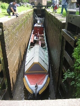
The canal consists of two level pounds, separated by a flight of 16 locksMarple Lock Flight
Marple Lock Flight is a flight of sixteen canal locks, situated on the Peak Forest Canal in Marple, near Stockport.-History:Whilst the rest of the canal was opened to navigation by 1796, insufficient money was available to complete the necessary flight of locks to connect the two halves, and a...
, which raise the canal by 209 feet (63.7 m) over the course of 1 miles (1.6 km).
The two pounds of the canal are generally known as the Upper Peak Forest Canal and Lower Peak Forest Canal. Whilst there is no evidence that these names were used historically, the designation Lower Peak Forest Canal was used in the British Waterways Act 1983, which redesignated the lower part of the canal as a Cruising Waterway.
Route
The Lower Peak Forest Canal heads south from Dukinfield JunctionDukinfield Junction
Dukinfield Junction is the name of the canal junction where the Peak Forest Canal terminates and meets the Ashton Canal near Ashton-under-Lyne, Greater Manchester, England...
at Dukinfield
Dukinfield
Dukinfield is a small town within the Metropolitan Borough of Tameside, in Greater Manchester, England. It lies in central Tameside on the south bank of the River Tame, opposite Ashton-under-Lyne, and is east of the city of Manchester...
in Greater Manchester
Greater Manchester
Greater Manchester is a metropolitan county in North West England, with a population of 2.6 million. It encompasses one of the largest metropolitan areas in the United Kingdom and comprises ten metropolitan boroughs: Bolton, Bury, Oldham, Rochdale, Stockport, Tameside, Trafford, Wigan, and the...
,where it makes a junction with the Ashton Canal
Ashton Canal
The Ashton Canal is a canal built in Greater Manchester in North West England.-Route:The Ashton leaves the Rochdale Canal at Ducie St. Junction in central Manchester, and climbs for through 18 locks, passing through Ancoats, Holt Town, Bradford-with-Beswick, Clayton, Openshaw, Droylsden,...
at the southern end of the Tame Aqueduct
River Tame, Greater Manchester
The River Tame flows through Greater Manchester, England.-Source:The Tame rises on Denshaw Moor in Greater Manchester, close to the border with West Yorkshire but within the historic West Riding of Yorkshire.-Course:...
through Newton, Hyde
Hyde, Greater Manchester
Hyde is a town in the Metropolitan Borough of Tameside, Greater Manchester, England. As of the 2001 census, the town had a population of 31,253. Historically part of Cheshire, it is northeast of Stockport, west of Glossop and east of Manchester....
, Woodley
Woodley, Greater Manchester
Woodley is a suburban area of the Metropolitan Borough of Stockport, in Greater Manchester, North West England. It lies on the east side of the Peak Forest Canal, next to the areas of Bredbury and Romiley...
, Bredbury
Bredbury
Bredbury is a suburban town within the Metropolitan Borough of Stockport, in Greater Manchester, England, located south east of Manchester, east of Stockport and south west of Hyde...
, Romiley
Romiley
Romiley is an area of the Metropolitan Borough of Stockport, Greater Manchester, England. It borders Marple, Bredbury and Woodley. In Roman times there is thought to have been a settlement along Sandy Lane...
, before crossing the River Goyt on Marple Aqueduct
Marple Aqueduct
Marple Aqueduct, also known as the Grand Aqueduct, carries the lower level of the Peak Forest Canal across the River Goyt at Marple, Greater Manchester, in north-west England....
, alongside a railway viaduct, to the foot of Marple Locks, a distance of 6.9 miles (11.1 km). The environs are largely rural, passing woods and fields, with some industrial premises encroaching towards the Dukinfield end of the pound.
Whilst the 1 miles (1.6 km) section through Marple Locks
Marple Lock Flight
Marple Lock Flight is a flight of sixteen canal locks, situated on the Peak Forest Canal in Marple, near Stockport.-History:Whilst the rest of the canal was opened to navigation by 1796, insufficient money was available to complete the necessary flight of locks to connect the two halves, and a...
is legally a part of the Lower Peak Forest Canal it is often considered as a separate section, raising the canal through 209 feet (63.7 m) in a partly woodland, partly municipal park, and partly urban setting through the centre of Marple. to connect with the Macclesfield Canal
Macclesfield Canal
The Macclesfield Canal is a canal in east Cheshire, England, one of the six that make up the Cheshire Ring.-Route:The canal runs from Marple Junction at Marple, where it joins the Upper Peak Forest Canal, , southwards , before arriving at Bosley.Having descended the 12 Bosley Locks over the course...
at Marple
Marple, Greater Manchester
Marple is a small town within the Metropolitan Borough of Stockport, in Greater Manchester, England. It lies on the River Goyt southeast of Stockport.Historically part of Cheshire, Marple has a population of 23,480 .-Toponymy:...
junction.
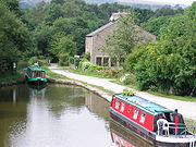
The Upper Peak Forest Canal is on the same level as that of the upper Macclesfield Canal
Macclesfield Canal
The Macclesfield Canal is a canal in east Cheshire, England, one of the six that make up the Cheshire Ring.-Route:The canal runs from Marple Junction at Marple, where it joins the Upper Peak Forest Canal, , southwards , before arriving at Bosley.Having descended the 12 Bosley Locks over the course...
, allowing boats to cruise from Whaley Bridge
Whaley Bridge
Whaley Bridge is a small town and civil parish in the High Peak district of Derbyshire, England, situated on the River Goyt. Whaley Bridge is approximately south of Manchester, north of Buxton , east of Macclesfield and west of Sheffield, and had a population of 6,226 at the 2001 census. This...
or Bugsworth all the way to the top lock at Bosley without having to use a lock. The canal is perched half way up the valley-side with extensive views of Furness Vale
Furness Vale
Furness Vale is a village in the High Peak district of Derbyshire, England situated between New Mills and Whaley Bridge. It is bisected by the A6 road and the Peak Forest Canal...
, and the Peak District beyond from Marple through Strines
Strines
Strines is a village in Greater Manchester, located in the valley of the River Goyt midway between Marple and New Mills and about six miles southeast of Stockport. The village falls mainly within Marple parish and Stockport metropolitan borough, though a small part falls within the boundaries of...
, Disley
Disley
Disley is a village and civil parish in the unitary authority of Cheshire East and the ceremonial county of Cheshire, England. It is located on the very edge of the Peak District, in the Goyt Valley, very close to the county boundary with Derbyshire at New Mills, and south of Stockport, Greater...
, New Mills
New Mills
New Mills is a town in Derbyshire, England approximately south-east of Stockport and from Manchester. It is sited at the confluence of the rivers Goyt and Sett, on the border of Cheshire. The town stands above the Torrs, a deep gorge, cut through Woodhead Hill Sandstone of the Carboniferous period...
, Furness Vale
Furness Vale
Furness Vale is a village in the High Peak district of Derbyshire, England situated between New Mills and Whaley Bridge. It is bisected by the A6 road and the Peak Forest Canal...
and Bridgemont. It terminates at Bugsworth Basin
Bugsworth Basin
Bugsworth Basin is a canal basin at the terminus of the Peak Forest Canal. It is located at Buxworth in the valley of the Black Brook, close to Whaley Bridge...
, Derbyshire
Derbyshire
Derbyshire is a county in the East Midlands of England. A substantial portion of the Peak District National Park lies within Derbyshire. The northern part of Derbyshire overlaps with the Pennines, a famous chain of hills and mountains. The county contains within its boundary of approx...
, a distance of 6.9 miles (11.1 km). The village was renamed Buxworth
Buxworth
Buxworth is a village in the High Peak of Derbyshire, England. The area, which was once an important centre for the limestone industry, became the terminus of the Peak Forest Canal. Its pub, the Navigation Inn, was once owned by Coronation Street actress Pat Phoenix...
in Victorian times. Recently, the extensive basin has been reopened, and is now a popular venue for visiting boats. There is also a short branch from Bridgemont to the centre of Whaley Bridge
Whaley Bridge
Whaley Bridge is a small town and civil parish in the High Peak district of Derbyshire, England, situated on the River Goyt. Whaley Bridge is approximately south of Manchester, north of Buxton , east of Macclesfield and west of Sheffield, and had a population of 6,226 at the 2001 census. This...
, once the site of a connection to the Cromford and High Peak Railway
Cromford and High Peak Railway
The Cromford and High Peak Railway in Derbyshire, England, was completed in 1831, to carry minerals and goods between the Cromford Canal wharf at High Peak Junction and the Peak Forest Canal at Whaley Bridge -Origins:...
, which ran across the Peak District and joined up with the Cromford Canal
Cromford Canal
The Cromford Canal ran 14.5 miles from Cromford to the Erewash Canal in Derbyshire, England with a branch to Pinxton. Built by William Jessop with the assistance of Benjamin Outram, its alignment included four tunnels and 14 locks....
.
Cruising rings
The section from Dukinfield Junction to Marple Junction is part of the Cheshire RingCheshire Ring
The Cheshire Ring is a popular canal cruising circuit, or canal ring which includes six of the canals in and around Cheshire, England.Because it takes approximately a week to complete, it is suited to narrowboat holidays which start and return to the same location. The route has 92 locks and is long...
route.
Authorisation
The canal was authorised by Act of Parliament in 1794 and its purpose was to provide an outlet for the vast limestone deposits around Dove HolesDove Holes
Dove Holes is a village in the High Peak district of Derbyshire, England. It has a population of about 1,200. It straddles the A6 road and it lies three miles from Buxton and three miles from Chapel-en-le-Frith. Trains run from Dove Holes railway station into Manchester.Residents of the village...
. As Dove Holes
Dove Holes
Dove Holes is a village in the High Peak district of Derbyshire, England. It has a population of about 1,200. It straddles the A6 road and it lies three miles from Buxton and three miles from Chapel-en-le-Frith. Trains run from Dove Holes railway station into Manchester.Residents of the village...
is over 1000 feet (304.8 m) above sea level, the canal was terminated in a basin at Bugsworth
Buxworth
Buxworth is a village in the High Peak of Derbyshire, England. The area, which was once an important centre for the limestone industry, became the terminus of the Peak Forest Canal. Its pub, the Navigation Inn, was once owned by Coronation Street actress Pat Phoenix...
, in Derbyshire
Derbyshire
Derbyshire is a county in the East Midlands of England. A substantial portion of the Peak District National Park lies within Derbyshire. The northern part of Derbyshire overlaps with the Pennines, a famous chain of hills and mountains. The county contains within its boundary of approx...
and the line was continued up to the quarries by means of a gravity operated feeder tramway, known as the Peak Forest Tramway
Peak Forest Tramway
The Peak Forest Tramway was an early horse- and gravity-powered industrial railway system in Derbyshire, England. Opened for trade on 31 August 1796, it remained in operation until the 1920s. Much of the route and the structures associated with the line remain...
, which was six miles (10 km) long.
Construction
The construction of the canal and tramway was promoted by Samuel OldknowSamuel Oldknow
thumb|Samuel OldknowSamuel Oldknow was an English cotton manufacturer.Samuel Oldknow Jnr, the eldest son of Samuel Oldknow Sr and Margaret Foster, was born 5 October 1756 in Anderton, near Chorley, Lancashire, and died 18 September 1828 at Mellor Lodge, Derbyshire. He had an elder sister named...
(the largest shareholder) with much of the finance being provided by Richard Arkwright Junior
Richard Arkwright Junior
Richard Arkwright junior , the son of the famous Sir Richard Arkwright of Cromford, Derbyshire, was the financier of Samuel Oldknow of Marple and Mellor and a personal friend. His son Captain Arkwright married Francis Kemble, daughter of the famous theatre manager Stephen Kemble.-Biography:Richard...
of Cromford
Cromford
Cromford is a village, two miles to the south of Matlock in the Derbyshire Dales district in Derbyshire, England. It is principally known for its historical connection with Richard Arkwright, and the Cromford Mill which he built here in 1771...
, Derbyshire
Derbyshire
Derbyshire is a county in the East Midlands of England. A substantial portion of the Peak District National Park lies within Derbyshire. The northern part of Derbyshire overlaps with the Pennines, a famous chain of hills and mountains. The county contains within its boundary of approx...
. The line was surveyed by Thomas Brown
Thomas Brown (engineer)
Thomas Brown was an English surveyor, civil engineer, businessman and landowner.Born at Disley in Cheshire, he had interests in coal-mining, particularly in the Haughton and Hyde areas of Greater Manchester, as well as lime burning and mineral extraction interests...
and the consulting engineer and resident engineer were Benjamin Outram
Benjamin Outram
Benjamin Outram was an English civil engineer, surveyor and industrialist. He was a pioneer in the building of canals and tramways.-Personal life:...
and Thomas Brown, respectively.
Work was begun first on the section between Ashton and Hyde Hall, where new coal-pits were being opened, so as to derive some income as soon as possible. Outram was somewhat delayed by a request from the committee to report on ideas by Robert Fulton
Robert Fulton
Robert Fulton was an American engineer and inventor who is widely credited with developing the first commercially successful steamboat...
who had been awarded the contract for the cuttings at Werneth. These would have replaced the stone construction of Marple Aqueduct by a somewhat flimsy cast iron trough. Outram, who was experiencing problems with the Holmes Aqueduct on the Derby Canal
Derby Canal
The Derby Canal ran from the Trent and Mersey Canal at Swarkestone to Derby and Little Eaton, and to the Erewash Canal at Sandiacre, Derbyshire, England. The canal gained its Act of Parliament in 1793 and was fully completed in 1796...
was well aware of potential weaknesses. Fulton had also suggested the use of small tub boats rather than conventional narrow boats, and an inclined plane at Marple instead of locks. Outram having privately voiced his disquiet, Fulton's plans were quietly dropped.
At the same time as Outram was working on the lower end, he came under pressure to make progress on the section Bugsworth to Marple, and Samuel Odknow's coal-pits and lime kilns. Splitting the work in this way possibly contributed to the £1100 overspend recorded in 1795, though there were problems getting the shareholders to meet their commitments. By 1796 this had risen to £4000, but in August the tramway and the canal opened to Marple.
Nevertheless at the end of 1796, funds from investors were still insufficient to finish the locks and the aqueduct at Marple and Outram was asked to suggest a temporary alternative. He produced two solutions, one to cross the arches of the aqueduct, the other assuming that the arches were unfinished. It was decided not to interfere with the ongoing construction of the aqueduct, so the railway ran from its Marple end to the proposed top lock. The arches of the aqueduct were completed in November 1798 - and the workers were given a "handsome treat" in celebration - being finally completed towards the end of 1799.
However, there was still a great of work to be done at the lower end - the driving of Hyde Bank Tunnel proving a particular problem - and the railway and aqueduct saw little use until the canal finally opened along its full length in 1800.
Operation
Bugsworth Basin
Bugsworth Basin is a canal basin at the terminus of the Peak Forest Canal. It is located at Buxworth in the valley of the Black Brook, close to Whaley Bridge...
soon became a bustling interchange between the tramway and canal.
Brown and Outram's efforts were much assisted by the appointment of Gernan Wheatcroft to manage the canal at Bugsworth and Whaley Bridge. He proved so efficient that he was able to use the threat of resignation to gain the addition of £30 to his £75 a year salary to keep and maintain a horse to assist him in his duties. In a move that would not disgrace a modern marketing organisation, the quarry owners retained Outram's future father-in-law, Dr. James Anderson, the Scottish agricultural expert, to write a treatise on the benefits of lime in farming, which they published.
Trade increased rapidly and it was becoming necessary to double the railways. Attracting suitable labour was also a problem. Cottages were rented to convert into dormitories, and Wheatcroft opened a shop where goods could be purchased cheaply. At one point, the employers offered "a good flannel waistcoat and trousers" for each worker, plus a jug of ale each day.
The Marple railway was still a serious bottleneck. The canal company still had not the funds to complete the Marple locks - and the reservoir at Combs that would be necessary. A petition to Parliament was considered but, finally, £24,000 was borrowed from Oldnow and Arkwright and the work was completed in 1805.
At Bugsworth, limestone brought down the tramway was either put into boats to be taken to Manchester
Manchester
Manchester is a city and metropolitan borough in Greater Manchester, England. According to the Office for National Statistics, the 2010 mid-year population estimate for Manchester was 498,800. Manchester lies within one of the UK's largest metropolitan areas, the metropolitan county of Greater...
and beyond or it was put into lime kilns to be burnt to produce quick lime. The trade in limestone and quick lime (also known as burnt lime), as well as the transport of coal into the basin for firing the kilns, accounted for the greatest proportion of the Canal Company's income.
Decline
With the coming of the railways, the canal began to lose its business and in the 1920s the Peak Forest Tramway and Bugsworth Basin closed. Later, the lower level of the canal and Marple locks fell into disuse, to the extent that by the early 1960s, the lower part of the canal was impassible.Restoration
In the late 1960s and early 1970s, the Peak Forest Canal Society, and Inland Waterways AssociationInland Waterways Association
The Inland Waterways Association was formed in 1946 as a registered charity in the United Kingdom to campaign for the conservation, use, maintenance, restoration and sensitive development of British Canals and river navigations....
campaigned for the restoration of the Peak Forest and Ashton Canals and they reopened on 1 April 1974. The Lower Peak Forest Canal, from Dukinfield Junction to Marple, was one of seven stretches of canal, formally designated as remainder waterways, which were re-classified by the British Waterways Act of 8 February 1983. Under the act, a total of 82 route miles (132 km) were upgraded to Cruising Waterway Standard.
Bugsworth Basin remained derelict for much longer. It was finally re-opened to navigation on 2003 after professional restoration work was undertaken by British Waterways
British Waterways
British Waterways is a statutory corporation wholly owned by the government of the United Kingdom, serving as the navigation authority in England, Scotland and Wales for the vast majority of the canals as well as a number of rivers and docks...
.