

Pascoag, Rhode Island
Encyclopedia
Census-designated place
A census-designated place is a concentration of population identified by the United States Census Bureau for statistical purposes. CDPs are delineated for each decennial census as the statistical counterparts of incorporated places such as cities, towns and villages...
(CDP) and village in Providence County
Providence County, Rhode Island
-Demographics:As of the census of 2000, there were 621,602 people, 239,936 households, and 152,839 families residing in the county. The population density was 1,504 people per square mile . There were 253,214 housing units at an average density of 613 per square mile...
, Rhode Island
Rhode Island
The state of Rhode Island and Providence Plantations, more commonly referred to as Rhode Island , is a state in the New England region of the United States. It is the smallest U.S. state by area...
, United States
United States
The United States of America is a federal constitutional republic comprising fifty states and a federal district...
. The population was 4,742 at the 2000 census
United States Census, 2000
The Twenty-second United States Census, known as Census 2000 and conducted by the Census Bureau, determined the resident population of the United States on April 1, 2000, to be 281,421,906, an increase of 13.2% over the 248,709,873 persons enumerated during the 1990 Census...
.
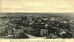
Pascoag is one of at least eight villages that make up Burrillville
Burrillville, Rhode Island
Burrillville is a town in Providence County, Rhode Island, United States. It was incorporated as an independent municipality on November 17, 1806 when the Rhode Island General Assembly authorized the residents of then North Glocester to elect its own officers. The population was 15,955 at the 2010...
. It can trace its origins back to the first half of the 18th century, when a saw mill and other businesses were built in what is now the village center.
In the 19th century, Pascoag became a textile manufacturing town, an industry that continued until after World War II
World War II
World War II, or the Second World War , was a global conflict lasting from 1939 to 1945, involving most of the world's nations—including all of the great powers—eventually forming two opposing military alliances: the Allies and the Axis...
.
Recent history includes an incident involving groundwater contamination. A test of the groundwater conducted on September 14, 2001 showed that the water contained the ether MTBE (methyl tertiary-butyl ether) at levels of about 600 ppb (Parts Per Billion). This was the first public statement concerning the presence of MTBE in Pascoag drinking water, though residents claim to have detected it as early as May, 2001. MTBE is a gasoline additive intended to enhance octane levels. It is believed to have come from leaking tanks at a local Exxon Mobil gas station. As the situation was resolved over the following months, nearly 1,500 residents of Pascoag responded by filing a lawsuit against Exxon Mobil through the law offices of Napoli, Kaiser, and Bern. The lawsuit is pending as of May 2, 2005. Official documents regarding the incident are archived at the Pascoag Utility District Homepage.
External Links: History of Pascoag (pdf)
Pascoag Utility District Homepage
Geography
Pascoag is located at 41°57′27"N 71°42′21"W (41.957401, -71.705957).According to the United States Census Bureau
United States Census Bureau
The United States Census Bureau is the government agency that is responsible for the United States Census. It also gathers other national demographic and economic data...
, the CDP has a total area of 14.1 km² (5.5 mi²). 13.0 km² (5.0 mi²) of it is land and 1.1 km² (0.4 mi²) of it (7.88%) is water.
Demographics
As of the censusCensus
A census is the procedure of systematically acquiring and recording information about the members of a given population. It is a regularly occurring and official count of a particular population. The term is used mostly in connection with national population and housing censuses; other common...
of 2000, there were 4,742 people, 1,642 households, and 1,175 families residing in the CDP. The population density
Population density
Population density is a measurement of population per unit area or unit volume. It is frequently applied to living organisms, and particularly to humans...
was 364.7/km² (944.4/mi²). There were 1,743 housing units at an average density of 134.1/km² (347.1/mi²). The racial makeup of the CDP was 98.33% White, 0.36% African American, 0.32% Native American, 0.27% Asian, 0.02% Pacific Islander, 0.17% from other races
Race (United States Census)
Race and ethnicity in the United States Census, as defined by the Federal Office of Management and Budget and the United States Census Bureau, are self-identification data items in which residents choose the race or races with which they most closely identify, and indicate whether or not they are...
, and 0.53% from two or more races. Hispanic or Latino of any race were 1.03% of the population.
There were 1,642 households out of which 37.6% had children under the age of 18 living with them, 56.3% were married couples
Marriage
Marriage is a social union or legal contract between people that creates kinship. It is an institution in which interpersonal relationships, usually intimate and sexual, are acknowledged in a variety of ways, depending on the culture or subculture in which it is found...
living together, 10.7% had a female householder with no husband present, and 28.4% were non-families. 23.0% of all households were made up of individuals and 10.1% had someone living alone who was 65 years of age or older. The average household size was 2.72 and the average family size was 3.20.
In the CDP the population was spread out with 26.5% under the age of 18, 7.4% from 18 to 24, 31.0% from 25 to 44, 19.7% from 45 to 64, and 15.4% who were 65 years of age or older. The median age was 37 years. For every 100 females there were 90.1 males. For every 100 females age 18 and over, there were 85.1 males.
The median income for a household in the CDP was $48,778, and the median income for a family was $54,391. Males had a median income of $37,957 versus $27,241 for females. The per capita income
Per capita income
Per capita income or income per person is a measure of mean income within an economic aggregate, such as a country or city. It is calculated by taking a measure of all sources of income in the aggregate and dividing it by the total population...
for the CDP was $20,322. About 6.4% of families and 9.0% of the population were below the poverty line, including 9.7% of those under age 18 and 15.4% of those age 65 or over.