
Parnitha
Encyclopedia
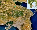
Mount Parnitha is a densely forested mountain
range north of Athens
, the highest on the peninsula of Attica
, with an elevation of 1,413 m and a summit known as Karavola (Καραβόλα). Much of the mountain is designated a national park
, and is a protected habitat for wildfowl, first created in 1961. The summit is located 18 km N of Acharnae and about 30 km N of Athens, while the mountain covers approximately 250 km² of land. Other peaks include Mavrovouni (Μαυροβούνι), Ornio (1,350 m), Area (1,160 m), Avgo or Avgho (1,150 m), and Xerovouni (Ξεροβούνι, meaning dry mountain - 1,120 m).It also has two shelters Mpafi
and Flampouri.
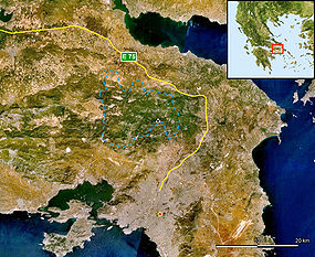 Towns surrounding the mountain include Aspropyrgos
(Thria
), Fyli
, Acharnae
/Menidi
, Varymbombi, Thrakomakedones, Decelea
, Avlona and Aghios Stefanos as well as the settlement of Agios Merkourios. The highway GR-1
aka E75
surrounds the northern and eastern part of the mountain along with the Cephissus
river, while the Attiki Odos
motorway (GR-6) runs to its south. The mountain offers panoramic views of the mountains northeast of Parnitha, Penteli
to the east, the Ymittos
to the southeast, the Aigaleo to the south and another to the west; from its summit, one can also see the Thriasian Plain
, the Saronic Gulf
including the islands of Salamina
, Aigina and the North, the South Euboean Gulfs and island of Euboea
, and most of central and northern Greater Athens. The view during clear days can extend to northern Viotia
and the Peloponnese
.
Forests of Greek Fir
and Aleppo Pine
cover all slopes beneath 1,000 m altitude, and are often threatened by forest fires, such as occurred in 2005 and 2007. Above 1,000 m it is covered principally in grasses and shrub
bery, and beneath 300 m mainly farmlands and suburban housing to the east. About 1,000 species of plants can be found on the mountain, including crocus
and tulips, and the mountain also provides a native habitat to its red deer, which were known in ancient times
. After the traumatic event listed below in 2007, they are even more scarce. Several large mines lie to the northwest, and the ore from them was shipped to a nearby factory in industrial areas.
A casino, the Mount Parnes Casino, is located near the top of the mountain and is served by a suspended cable car. Two shelters are also located on Parnitha, the most known of which is Mpafi
. A series of trails are found around the mountain as well as forest roads, and also on the mountain is Athens' second transmitter, broadcasting radio and television since the mid-1950s, across the range of television channels from ERT
, ANT1
, Mega
, Alter
and more, to satellite, including Super Sport
, Seven X and Filmnet
, and a multitude of radio including ERA Radio, Klik FM, ANT1 Radio, Ciao FM, Rhythmos, Super Sport FM, Top FM and others. The supporting road connection was paved in the mid-20th century.
The mountain was also affected by several major blizzards, including two in 2005 and 2006, stranding cars and closing roads, as well as the cable car.
The name of the mountain dates back to ancient times
, when it was under the ancient deme
s of Acharnae
and Decelea
.
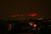
 Parnitha suffered extensive damage from a wildfire
on Thursday, June 28, 2007 around the morning and noon hours, continuing for several days and burning approximately 56 km² of land; one of the worst recorded wildfires in the prefecture after that of Penteli
. The magnitude of the devastation was unforeseen. A smaller fire had, however, taken place in the 1960s.
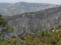
The fire consumed forests in two prefectures. Firefighters, helicopters, and planes were brought into action across the mountain area and its edges fighting the enormous blaze,which took days to contain. It spread rapidly with the help of intense winds, and intensified into the northwestern edges of Greater Athens
, including both Ano Liosia
and towns and villages such as Fyli, near Thrakomakedones, Pyli
and both Skoura
and Schimatari
north of the mountain. From Athens, inhabitants could see the mountainside burning throughout the night. In Schimatari in Viotia, it ruined several acres of forest and businesses. The fire claimed an 80% proportion of the rare Greek Fir and Aleppo Pine forest, 150 animals of the red deer population (an endangered species), birds, and other rare animals. The remains of the green firs and pines are sporadically located around its edges; the scene now resembles that of a devastated forest or an ugly winter. With the loss of its pine needles, one can see the horrifying bareness of the mountain slopes, summit, and valleys. Smoke was seen from most of the Athens area, even the west central and west suburbs, the downtown area, the northern suburbs and almost every part of Viotia, except for most of the western and northernmost portions. The smoke from the massive destruction formed a line that traveled east over Attica, southern Euboea
, Chios
, to the edge of Turkey
, at a distance of approximately 350 km.
On June 30, the fire was mostly contained and warnings of new ones were reduced, as only a few fires were slowly burning sporadically in separate parts of the mountain. The main blaze was completely put out on July 1. At the edges of the burnt parts, several fires slowly continued to burn in sections after June 30, with a slow expansion.
Scientists estimate the area's recovery time may be as long as a century. They predict the effect of the loss will only begin to be felt in the coming years; the air may become a little stale and the already known problems of air pollution and smog in Athens may reappear and intensify. Temperatures could also rise and flooding may become a problem for several years. The Ministry of Environment is currently considering a conclusive reforestation program, while many citizens plan to march on the streets of Athens to express their disapproval of the handling of the situation. More recently, forestation has been underway, and the government will be receiving tens of thousands of trees to be planted around the mountains, most of them from outside the country.
Investigations are still underway as to the fire's cause. One scenario suggests a transformer belonging to a major power line exploded due to overuse and overheating by the 47C heatwave, some days prior to the fire. Another holds that this was one of the many arson attacks that have claimed forested land in Greece over recent decades.
Mountain
Image:Himalaya_annotated.jpg|thumb|right|The Himalayan mountain range with Mount Everestrect 58 14 160 49 Chomo Lonzorect 200 28 335 52 Makalurect 378 24 566 45 Mount Everestrect 188 581 920 656 Tibetan Plateaurect 250 406 340 427 Rong River...
range north of Athens
Athens
Athens , is the capital and largest city of Greece. Athens dominates the Attica region and is one of the world's oldest cities, as its recorded history spans around 3,400 years. Classical Athens was a powerful city-state...
, the highest on the peninsula of Attica
Attica
Attica is a historical region of Greece, containing Athens, the current capital of Greece. The historical region is centered on the Attic peninsula, which projects into the Aegean Sea...
, with an elevation of 1,413 m and a summit known as Karavola (Καραβόλα). Much of the mountain is designated a national park
National parks in Greece
Greece is characterized by an extremely fragmented, rugged landscape hosting a great diversity of ecosystems and an outstanding biodiversity. Almost 5% of its extensive coastline consists of ecologically sensitive wetlands...
, and is a protected habitat for wildfowl, first created in 1961. The summit is located 18 km N of Acharnae and about 30 km N of Athens, while the mountain covers approximately 250 km² of land. Other peaks include Mavrovouni (Μαυροβούνι), Ornio (1,350 m), Area (1,160 m), Avgo or Avgho (1,150 m), and Xerovouni (Ξεροβούνι, meaning dry mountain - 1,120 m).It also has two shelters Mpafi
Mpafi
The Bafi Refuge refuge belongs to the Greek Mountaineering Club, E.O.S. Athens founded in 1928 and is in the Mount Parnitha National Park, at an altitude of 1160m, roughly 2.5 km from Mont Parness, inside the national park. Ιn April 1937 the refuge's foundation stone was laid...
and Flampouri.
Geography
Aspropyrgos
Aspropyrgos is a suburb of Athens, and a municipality in the West Attica regional unit, Attica, Greece. It is located 20 km NW of the city center of Athens in the Thriasian plain...
(Thria
Thria
Thria is a genus of moths of the Noctuidae family.-References:*...
), Fyli
Fyli
Fyli is a town and a municipality in the northwestern part of Attica, Greece. It lies in the northeastern corner of the West Attica regional unit, and is a suburb of Athens...
, Acharnae
Acharnae
Acharnae was the largest deme of ancient Attica; it was located in the northwest part of the Attic plain, south of Mt. Parnes in the general vicinity of the modern suburbs of Acharnes and Ano Liosia, about due north of Athens. The Acharnians chiefly grew cereals, grapes, and olives, although...
/Menidi
Menidi
Menidi may refer to the following places in Greece:*Menidi, Aetolia-Acarnania*Menidi, an alternative name for Acharnes, Attica...
, Varymbombi, Thrakomakedones, Decelea
Decelea
Decelea , modern Dekeleia or Dekelia, Deceleia or Decelia, previous name Tatoi, was an ancient village in northern Attica serving as a trade route connecting Euboea with Athens, Greece. The historian Herodotus reports that its citizens enjoyed a special relationship with Sparta. The Spartans took...
, Avlona and Aghios Stefanos as well as the settlement of Agios Merkourios. The highway GR-1
Greek National Road 1
The Greek Motorway 1 is a motorway, partly under construction, and the 2nd longest in Greece. It is the principal north-south road connection in Greece, connecting the country's capital Athens with the regions of Thessaly and Macedonia, as well as the country's second largest city,...
aka E75
European route E75
European route E 75 is part of the International E-road network, which is a series of main roads in Europe.The E 75 starts from Vardø, Norway in the Barents Sea and runs south through Finland, Poland, Czech Republic, Slovakia, Hungary, Serbia and Republic of Macedonia to Sitia, Greece on...
surrounds the northern and eastern part of the mountain along with the Cephissus
Cephissus (Athenian plain)
Cephissus , Kifissós) or Cephisus Kifisos), a river flowing through the Athenian plain.In his summary of Greek mythology Apollodorus declares that Erechtheus' wife Praxithea was daughter of Phrasimus by Diogenia daughter of Cephissus.This river is found in the western part of the...
river, while the Attiki Odos
Attiki Odos
Attiki Odos is a privately owned toll motorway in Greece. The Proastiakos high-speed suburban rail is set almost entirely in the median of the motorway, along its main section. The motorway's numbers are 6 for the main section, 64 for the Hymettus Beltway and 65 for the Aigaleo Beltway...
motorway (GR-6) runs to its south. The mountain offers panoramic views of the mountains northeast of Parnitha, Penteli
Penteli
Pentéli or Pendeli, , and Vrilissos or Vrilittos , Mendeli in medieval times) is a tall mountain and mountain range situated northeast of Athens and southwest of Marathon. Its elevation is 1,109 m...
to the east, the Ymittos
Ymittos
Ymittos , is a suburb of Athens, Greece. Since the 2011 local government reform it is part of the municipality Dafni-Ymittos, of which it is a municipal unit....
to the southeast, the Aigaleo to the south and another to the west; from its summit, one can also see the Thriasian Plain
Thriasian Plain
The Thriasian Plain is a plain in western Attica, immediately to the west of Athens, in Greece. It is bounded by Mount Egaleo to the east, Mount Parnitha to the north, Mount Pateras to the west, and the Bay of Eleusina to the south.-History:...
, the Saronic Gulf
Saronic Gulf
The Saronic Gulf or Gulf of Aegina in Greece forms part of the Aegean Sea and defines the eastern side of the isthmus of Corinth. It is the eastern terminus of the Corinth Canal, which cuts across the isthmus.-Geography:The gulf includes the islands of; Aegina, Salamis, and Poros along with...
including the islands of Salamina
Salamis Island
Salamis , is the largest Greek island in the Saronic Gulf, about 1 nautical mile off-coast from Piraeus and about 16 km west of Athens. The chief city, Salamina , lies in the west-facing core of the crescent on Salamis Bay, which opens into the Saronic Gulf...
, Aigina and the North, the South Euboean Gulfs and island of Euboea
Euboea
Euboea is the second largest Greek island in area and population, after Crete. The narrow Euripus Strait separates it from Boeotia in mainland Greece. In general outline it is a long and narrow, seahorse-shaped island; it is about long, and varies in breadth from to...
, and most of central and northern Greater Athens. The view during clear days can extend to northern Viotia
Boeotia
Boeotia, also spelled Beotia and Bœotia , is one of the regional units of Greece. It is part of the region of Central Greece. It was also a region of ancient Greece. Its capital is Livadeia, the second largest city being Thebes.-Geography:...
and the Peloponnese
Peloponnese
The Peloponnese, Peloponnesos or Peloponnesus , is a large peninsula , located in a region of southern Greece, forming the part of the country south of the Gulf of Corinth...
.
Forests of Greek Fir
Greek Fir
Greek Fir is a fir native to the mountains of Greece, primarily in the Peloponnesos and the island of Kefallonia, intergrading with the closely related Bulgarian Fir further north in the Pindus mountains of northern Greece. It is a medium-size evergreen coniferous tree growing to – rarely – tall...
and Aleppo Pine
Aleppo Pine
Pinus halepensis, commonly known as the Aleppo Pine, is a pine native to the Mediterranean region. Their range extends from Morocco and Spain north to southern France, Italy and Croatia, and east to Greece and northern Tunisia, and Libya, with an outlying population in Syria, Lebanon, southern...
cover all slopes beneath 1,000 m altitude, and are often threatened by forest fires, such as occurred in 2005 and 2007. Above 1,000 m it is covered principally in grasses and shrub
Shrub
A shrub or bush is distinguished from a tree by its multiple stems and shorter height, usually under 5–6 m tall. A large number of plants may become either shrubs or trees, depending on the growing conditions they experience...
bery, and beneath 300 m mainly farmlands and suburban housing to the east. About 1,000 species of plants can be found on the mountain, including crocus
Crocus
Crocus is a genus in the iris family comprising about 80 species of perennials growing from corms. Many are cultivated for their flowers appearing in autumn, winter, or spring...
and tulips, and the mountain also provides a native habitat to its red deer, which were known in ancient times
Ancient Greece
Ancient Greece is a civilization belonging to a period of Greek history that lasted from the Archaic period of the 8th to 6th centuries BC to the end of antiquity. Immediately following this period was the beginning of the Early Middle Ages and the Byzantine era. Included in Ancient Greece is the...
. After the traumatic event listed below in 2007, they are even more scarce. Several large mines lie to the northwest, and the ore from them was shipped to a nearby factory in industrial areas.
A casino, the Mount Parnes Casino, is located near the top of the mountain and is served by a suspended cable car. Two shelters are also located on Parnitha, the most known of which is Mpafi
Mpafi
The Bafi Refuge refuge belongs to the Greek Mountaineering Club, E.O.S. Athens founded in 1928 and is in the Mount Parnitha National Park, at an altitude of 1160m, roughly 2.5 km from Mont Parness, inside the national park. Ιn April 1937 the refuge's foundation stone was laid...
. A series of trails are found around the mountain as well as forest roads, and also on the mountain is Athens' second transmitter, broadcasting radio and television since the mid-1950s, across the range of television channels from ERT
Elliniki Radiofonia Tileorasi
The Hellenic Broadcasting Corporation is the Greek state-owned public radio and television broadcasting corporation. It is a member of EBU.Since 70's ERT is part of the Eurovision Song Contest, organized by EBU...
, ANT1
ANT1
Antenna, better known as ANT1, is a television network airing in Greece and Cyprus. The alternate spelling is play on words in Greek; ena is the Greek number 1, thus ANT1 is pronounced the same as Antenna . It launched on 31 December 1989, the same year as rival Mega Channel, and is owned by...
, Mega
Mega Channel
Mega Channel, also known as Mega TV or just Mega, is a major television network in Greece. Teletypos S.A. was founded in 1989 under the name Teletypos Television Programmes S.A...
, Alter
Alter Channel
Alter Channel better known as Alter, is a private TV network in Greece. It launched in 1994 and is owned by Eleftheri Tileorasi S.A, which is headed by Andreas Kouris. Programming mainly consists of news & current affairs shows and entertainment programmes...
and more, to satellite, including Super Sport
Super Sport
Super Sport, or SS, is the signature performance option package offered by Chevrolet, a United States Auto Maker, on a limited number of its vehicles. All SS models come with distinctive "SS" markings on their exterior. The package was first made available for the 1961 Impala...
, Seven X and Filmnet
Filmnet
Nova Cinema is a premium television service available in Greece that broadcasts blockbuster movies and hit series. It is the only 24/7 Movie service in Greece and it launched in 1994. It is owned by Forthnet, who own and operate Nova a DTH satellite service and Nova Sports—a sports channel.Nova...
, and a multitude of radio including ERA Radio, Klik FM, ANT1 Radio, Ciao FM, Rhythmos, Super Sport FM, Top FM and others. The supporting road connection was paved in the mid-20th century.
The mountain was also affected by several major blizzards, including two in 2005 and 2006, stranding cars and closing roads, as well as the cable car.
The name of the mountain dates back to ancient times
Ancient Greece
Ancient Greece is a civilization belonging to a period of Greek history that lasted from the Archaic period of the 8th to 6th centuries BC to the end of antiquity. Immediately following this period was the beginning of the Early Middle Ages and the Byzantine era. Included in Ancient Greece is the...
, when it was under the ancient deme
Deme
In Ancient Greece, a deme or demos was a subdivision of Attica, the region of Greece surrounding Athens. Demes as simple subdivisions of land in the countryside seem to have existed in the 6th century BC and earlier, but did not acquire particular significance until the reforms of Cleisthenes in...
s of Acharnae
Acharnae
Acharnae was the largest deme of ancient Attica; it was located in the northwest part of the Attic plain, south of Mt. Parnes in the general vicinity of the modern suburbs of Acharnes and Ano Liosia, about due north of Athens. The Acharnians chiefly grew cereals, grapes, and olives, although...
and Decelea
Decelea
Decelea , modern Dekeleia or Dekelia, Deceleia or Decelia, previous name Tatoi, was an ancient village in northern Attica serving as a trade route connecting Euboea with Athens, Greece. The historian Herodotus reports that its citizens enjoyed a special relationship with Sparta. The Spartans took...
.
2007 wildfire
Wildfire
A wildfire is any uncontrolled fire in combustible vegetation that occurs in the countryside or a wilderness area. Other names such as brush fire, bushfire, forest fire, desert fire, grass fire, hill fire, squirrel fire, vegetation fire, veldfire, and wilkjjofire may be used to describe the same...
on Thursday, June 28, 2007 around the morning and noon hours, continuing for several days and burning approximately 56 km² of land; one of the worst recorded wildfires in the prefecture after that of Penteli
Penteli
Pentéli or Pendeli, , and Vrilissos or Vrilittos , Mendeli in medieval times) is a tall mountain and mountain range situated northeast of Athens and southwest of Marathon. Its elevation is 1,109 m...
. The magnitude of the devastation was unforeseen. A smaller fire had, however, taken place in the 1960s.
The fire consumed forests in two prefectures. Firefighters, helicopters, and planes were brought into action across the mountain area and its edges fighting the enormous blaze,which took days to contain. It spread rapidly with the help of intense winds, and intensified into the northwestern edges of Greater Athens
Attica
Attica is a historical region of Greece, containing Athens, the current capital of Greece. The historical region is centered on the Attic peninsula, which projects into the Aegean Sea...
, including both Ano Liosia
Ano Liosia
Ano Liosia is a suburb and a former municipality in the northern part of the Athens agglomeration, Greece. Since the 2011 local government reform it is part of the municipality Fyli, of which it is the seat and a municipal unit....
and towns and villages such as Fyli, near Thrakomakedones, Pyli
Pyli, Greece
Pyli is a village in Boeotia, Greece. Its 2001 population was 666 for the village and 820 for the municipal district. It was the seat of the municipality of Dervenochoria. Pyli is part of the Greater Athens area. Pyli is linked with the road linking Elefsina and Schimatari along with the GR-1...
and both Skoura
Skoura
Skoura is a town in Ouarzazate Province, Souss-Massa-Draâ, Morocco. According to the 2004 census it has a population of 2,808....
and Schimatari
Schimatari
Schimatari is a town and a former municipality in Boeotia, Greece. Since the 2011 local government reform it is part of the municipality Tanagra, of which it is the seat and a municipal unit. Population 8,095 . The Asopus River is 3 to 4 km to the south. The Greek National Road 1 passes...
north of the mountain. From Athens, inhabitants could see the mountainside burning throughout the night. In Schimatari in Viotia, it ruined several acres of forest and businesses. The fire claimed an 80% proportion of the rare Greek Fir and Aleppo Pine forest, 150 animals of the red deer population (an endangered species), birds, and other rare animals. The remains of the green firs and pines are sporadically located around its edges; the scene now resembles that of a devastated forest or an ugly winter. With the loss of its pine needles, one can see the horrifying bareness of the mountain slopes, summit, and valleys. Smoke was seen from most of the Athens area, even the west central and west suburbs, the downtown area, the northern suburbs and almost every part of Viotia, except for most of the western and northernmost portions. The smoke from the massive destruction formed a line that traveled east over Attica, southern Euboea
Euboea
Euboea is the second largest Greek island in area and population, after Crete. The narrow Euripus Strait separates it from Boeotia in mainland Greece. In general outline it is a long and narrow, seahorse-shaped island; it is about long, and varies in breadth from to...
, Chios
Chios
Chios is the fifth largest of the Greek islands, situated in the Aegean Sea, seven kilometres off the Asia Minor coast. The island is separated from Turkey by the Chios Strait. The island is noted for its strong merchant shipping community, its unique mastic gum and its medieval villages...
, to the edge of Turkey
Turkey
Turkey , known officially as the Republic of Turkey , is a Eurasian country located in Western Asia and in East Thrace in Southeastern Europe...
, at a distance of approximately 350 km.
On June 30, the fire was mostly contained and warnings of new ones were reduced, as only a few fires were slowly burning sporadically in separate parts of the mountain. The main blaze was completely put out on July 1. At the edges of the burnt parts, several fires slowly continued to burn in sections after June 30, with a slow expansion.
Scientists estimate the area's recovery time may be as long as a century. They predict the effect of the loss will only begin to be felt in the coming years; the air may become a little stale and the already known problems of air pollution and smog in Athens may reappear and intensify. Temperatures could also rise and flooding may become a problem for several years. The Ministry of Environment is currently considering a conclusive reforestation program, while many citizens plan to march on the streets of Athens to express their disapproval of the handling of the situation. More recently, forestation has been underway, and the government will be receiving tens of thousands of trees to be planted around the mountains, most of them from outside the country.
Investigations are still underway as to the fire's cause. One scenario suggests a transformer belonging to a major power line exploded due to overuse and overheating by the 47C heatwave, some days prior to the fire. Another holds that this was one of the many arson attacks that have claimed forested land in Greece over recent decades.