

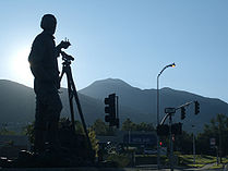
Parley's Canyon
Encyclopedia
United States
The United States of America is a federal constitutional republic comprising fifty states and a federal district...
state of Utah
Utah
Utah is a state in the Western United States. It was the 45th state to join the Union, on January 4, 1896. Approximately 80% of Utah's 2,763,885 people live along the Wasatch Front, centering on Salt Lake City. This leaves vast expanses of the state nearly uninhabited, making the population the...
. The canyon provides the route of Interstate 80 (and previously the Lincoln Highway
Lincoln Highway
The Lincoln Highway was the first road across the United States of America.Conceived and promoted by entrepreneur Carl G. Fisher, the Lincoln Highway spanned coast-to-coast from Times Square in New York City to Lincoln Park in San Francisco, originally through 13 states: New York, New Jersey,...
and U.S. Route 40
U.S. Route 40
U.S. Route 40 is an east–west United States highway. As with most routes whose numbers end in a zero, U.S. 40 once traversed the entire United States. It is one of the original 1920s U.S. Highways, and its first termini were San Francisco, California, and Atlantic City, New Jersey...
) up the western slope of the Wasatch Mountains and is a relatively wide, straight canyon. The lower part of the canyon, however, is relatively twisty and had to be dynamite
Dynamite
Dynamite is an explosive material based on nitroglycerin, initially using diatomaceous earth , or another absorbent substance such as powdered shells, clay, sawdust, or wood pulp. Dynamites using organic materials such as sawdust are less stable and such use has been generally discontinued...
d to make way for I-80. Despite this, the interstate remains six lanes wide throughout the canyon. Parley's Canyon begins where Interstate 215
Interstate 215 (Utah)
Interstate 215 , also known locally as the belt route or two-fifteen, is an auxiliary interstate in the U.S. state of Utah that forms a 270-degree loop around Salt Lake City and many of its suburbs...
merges into I-80 in Salt Lake City
Salt Lake City, Utah
Salt Lake City is the capital and the most populous city of the U.S. state of Utah. The name of the city is often shortened to Salt Lake or SLC. With a population of 186,440 as of the 2010 Census, the city lies in the Salt Lake City metropolitan area, which has a total population of 1,124,197...
and ends at Parley's Summit
Parley's Summit
Parleys Summit is a mountain pass in the Wasatch Mountains in Utah traversed by Interstate 80. It is the summit of Parleys Canyon, and the town of Summit Park is nearby....
. On the other side of the summit the freeway unfolds into the Snyderville Basin
Snyderville Basin
The Snyderville Basin is a valley in Summit County, Utah adjacent to Park City. Many of the residents of the Park City area live in the Snyderville Basin. Though the area lies outside of the Park City limits, and receives many services from Summit County instead of Park City, it is part of the...
, which is where the popular resort town of Park City
Park City, Utah
Park City is a town in Summit and Wasatch counties in the U.S. state of Utah. It is considered to be part of the Wasatch Back. The city is southeast of downtown Salt Lake City and from Salt Lake City's east edge of Sugar House along Interstate 80. The population was 7,558 at the 2010 census...
is located. Clearly visible as you enter the basin is the ski jump built for the 2002 Winter Olympic Games and the large shopping district that has manifested itself around Kimball Junction. The upper portion of the canyon is part of the Summit Park
Summit Park, Utah
Summit Park is a census-designated place in Summit County, Utah, United States. The population was 6,597 at the 2000 census.-Geography:Summit Park is located at ....
census-designated place
Census-designated place
A census-designated place is a concentration of population identified by the United States Census Bureau for statistical purposes. CDPs are delineated for each decennial census as the statistical counterparts of incorporated places such as cities, towns and villages...
(CDP). However, this area is more commonly referred to as Jeremy Ranch or Parley's Summit. Here, the canyon is wide enough to form large communities along the sides of the freeway along the gentle mountain slopes.
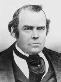
The canyon receives its name from Parley P. Pratt
Parley P. Pratt
Parley Parker Pratt, Sr. was a leader in the Latter Day Saint movement and an original member of Quorum of the Twelve Apostles from 1835 until his murder in 1857. He served in the Quorum with his younger brother, Orson Pratt...
who was assigned to explore the canyon, called Big Canyon at the time, and to build a toll road, called the Golden Pass Toll Road. Construction on the road started in 1848 and was completed in 1850. The road through Parley's Canyon became the primary route into the Salt Lake Valley
Salt Lake Valley
Salt Lake Valley is a valley in Salt Lake County in the north-central portion of the U.S. state of Utah. It contains Salt Lake City and many of its suburbs, notably West Valley City, Murray, Sandy, and West Jordan; its total population is 1,029,655 as of 2010...
, surpassing the original route through Emigration Canyon
Emigration Canyon
Emigration Canyon is a CDP, township and canyon in Salt Lake County, Utah, United States, located east of Salt Lake City in the Wasatch Range. Beginning at the southern end of the University of Utah, the canyon itself heads east and northeast between Salt Lake City and Morgan County. The boundaries...
.