
Parallel 36°30' north
Encyclopedia
The parallel 36° 30′ north is a circle of latitude
that is 36 and one-half degrees
north of the Equator
of the Earth. This parallel of latitude is particularly significant in the History of the United States
as the line of the Missouri Compromise
, which was used to divide the prosepctiveslave and free states west of the Mississippi River
, with the exception of Missouri
, which is mostly north of this parallel. This parallel also crosses the Atlantic
and Pacific Ocean
s, California
(which was admited as a free state in 1850), and parts the Mediterranean Sea
, northmost North Africa
, Italy
, and Asia
, and it ran though the former slave state
s of Virginia
, North Carolina
, Kentucky
, and Tennessee
, dividing them roughly in half.
and the Kentucky
, in the region west the Tennessee River
and east of the Mississippi River
. This parallel also forms part of the boundary between Missouri
and Arkansas
, in the region west of the White River
and east of Oklahoma
, and also the northern boundary of the Texas Panhandle
(see: Texas
and Oklahoma
. The rest of the boundaries between Virginia
and North Carolina
; between Virginia and Tennessee
; and between Tennessee and Kentucky
lie clost to the parallel 36° 30′. The reason why the entire boundary between Kentucky and Tennessee does not follow this parallel is because of numerous surveying
mistakes that were made during the 17th century
, when surverying technology was not very advanced. There were serious problems especially where the Cumberland River
crosses this boundary twice and where the Tennessee River
crosses it once.
The parallel 36° 30′ north is part of a nearly straight east-west line of state borders (with small variations) starting on the East Coast of the United States
, beginning with the border between Virginia and North Carolina. However, this boundary line lies a few mile
s north of 36° 30′ in laces, and much of the border between Kentucky and Tennessee lies a few miles north of 36° 30′.
In southeastern Missouri
, the Missouri Bootheel along the Mississippi River
extends about 50 miles (80 kilometers) to the south, all the way to the 36th parallel north
, and about 30 miles (50 kilometers) inland. This was because politicians in that region along that major river felt thought that it would be advantageous to be located in Missouri rather than in the Arkansas Territory
that became the State of Arkansas in 1836. The parallel 36° 30′ then forms the rest of the boundary between Missouri and Arkansas.
The Missouri Compromise
of 1820 established the latitude 36° 30′ as the northern limit for slavery
to be legal in the territories of the west. As part of this compromise, Maine
(formerly a part of Massachussets was admitted as a free state, of course, in order to maintain the balance of power in the U.S. Senate between the free states and the slaveholding states.
The bulk of Missouri lies north of the 36° 30′ line, but Southern plantation
owners who lived in southeatern Missouri wanted to have slavery there, especially for farming on their cotton
plantations. Hence, part of the Missouri Compromise arose from this factor. Also, the slave states of the Southern United States
wanted to have another slave state on their side so that the Senate could not pass laws that wuuld abolish slavery in the United States. This sitution remained in effect for decades because as the free states of Michigan
, Wisconsin
, and Iowa
were admitted to the Union, the new slave states of Arkansas
, Florida
, and Texas
were also admitted.
When the Republic of Texas
joined the United States in 1845, it was required to cede all of its claimed land north of the 36° 30′ latitude to the Federal Government. Over the following half-century, this land became parts of Kansas
, Colorado
, New Mexico
, and Oklahoma
.
The Compromise of 1850
confirmed that the 36° 30′ parallel was the northmost boundary of Texas
. Then, Kansas was admitted to the Union as a free state in 1859.
The creation of the New Mexico Territory
and the Utah Territory
in 1850, the Kansas Territory
in 1854, and the Colorado Territory
in 1861 moved the boundaries of the one western territories, New Mexico, north to the 37th parallel north
. New Mexico Territory was eventually split in two states, New Mexico and Arizona
, which were admitted in 1911 - 12, but this was long after the 13th Amendment has abolished slavery in all of the United States.
The gap between the northern boundary of Texas on the parallel 36°30′ north and the southern boundaries of Kansas
and Colorado
on the parallel 37° north created the No Man's Land that later became the Oklahoma Panhandle
in 1889. While a significant part of Nevada
(containing Las Vegas) is south of 36° 30′, at the time of the admission of Nevada in 1864, it was in the New Mexico Territory. This land was not split off from the new Arizona Territory
until 1871, when it was given to Nevada by the Federal government.
The Compromise of 1850 made no attempt to divide California
along the line of 36° 30′, or to allow slavery south of it. In facr, California was immediately admitted to the union as a free state
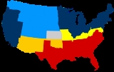
During the War Between the States
(1861 - 65), all of the states south of 36° 30′ north except for California
, joined the Confederate States of America
. All of the states north of the parallel, except for Virginia, stayed in the Union, although Kentucky
and Missouri
had Confederate legislatures that were elected in parallel with their regular legislatures. Also Maryland
, another slave state, was occupied by the Union Army
under the commands of President Lincoln, and its legislature was thus pressured into voting not to secede. Naturally, Lincoln and the remaining members of the U.S. Congress wanted Maryland to stay in the Union in order to prevent the national capital city
of Washington, D.C.
from being surrounded by Confederate states, and hence being cut off from the rest of the Union. If such a thing had happened, then the Federal government would have been forced to move somewhere else farther north, such as to Philadelphia.
and heading eastwards, the parallel 36° 30′ north passes through:
Circle of latitude
A circle of latitude, on the Earth, is an imaginary east-west circle connecting all locations that share a given latitude...
that is 36 and one-half degrees
Degree (angle)
A degree , usually denoted by ° , is a measurement of plane angle, representing 1⁄360 of a full rotation; one degree is equivalent to π/180 radians...
north of the Equator
Equator
An equator is the intersection of a sphere's surface with the plane perpendicular to the sphere's axis of rotation and containing the sphere's center of mass....
of the Earth. This parallel of latitude is particularly significant in the History of the United States
History of the United States
The history of the United States traditionally starts with the Declaration of Independence in the year 1776, although its territory was inhabited by Native Americans since prehistoric times and then by European colonists who followed the voyages of Christopher Columbus starting in 1492. The...
as the line of the Missouri Compromise
Missouri Compromise
The Missouri Compromise was an agreement passed in 1820 between the pro-slavery and anti-slavery factions in the United States Congress, involving primarily the regulation of slavery in the western territories. It prohibited slavery in the former Louisiana Territory north of the parallel 36°30'...
, which was used to divide the prosepctiveslave and free states west of the Mississippi River
Mississippi River
The Mississippi River is the largest river system in North America. Flowing entirely in the United States, this river rises in western Minnesota and meanders slowly southwards for to the Mississippi River Delta at the Gulf of Mexico. With its many tributaries, the Mississippi's watershed drains...
, with the exception of Missouri
Missouri
Missouri is a US state located in the Midwestern United States, bordered by Iowa, Illinois, Kentucky, Tennessee, Arkansas, Oklahoma, Kansas and Nebraska. With a 2010 population of 5,988,927, Missouri is the 18th most populous state in the nation and the fifth most populous in the Midwest. It...
, which is mostly north of this parallel. This parallel also crosses the Atlantic
Atlantic Ocean
The Atlantic Ocean is the second-largest of the world's oceanic divisions. With a total area of about , it covers approximately 20% of the Earth's surface and about 26% of its water surface area...
and Pacific Ocean
Pacific Ocean
The Pacific Ocean is the largest of the Earth's oceanic divisions. It extends from the Arctic in the north to the Southern Ocean in the south, bounded by Asia and Australia in the west, and the Americas in the east.At 165.2 million square kilometres in area, this largest division of the World...
s, California
California
California is a state located on the West Coast of the United States. It is by far the most populous U.S. state, and the third-largest by land area...
(which was admited as a free state in 1850), and parts the Mediterranean Sea
Mediterranean Sea
The Mediterranean Sea is a sea connected to the Atlantic Ocean surrounded by the Mediterranean region and almost completely enclosed by land: on the north by Anatolia and Europe, on the south by North Africa, and on the east by the Levant...
, northmost North Africa
North Africa
North Africa or Northern Africa is the northernmost region of the African continent, linked by the Sahara to Sub-Saharan Africa. Geopolitically, the United Nations definition of Northern Africa includes eight countries or territories; Algeria, Egypt, Libya, Morocco, South Sudan, Sudan, Tunisia, and...
, Italy
Italy
Italy , officially the Italian Republic languages]] under the European Charter for Regional or Minority Languages. In each of these, Italy's official name is as follows:;;;;;;;;), is a unitary parliamentary republic in South-Central Europe. To the north it borders France, Switzerland, Austria and...
, and Asia
Asia
Asia is the world's largest and most populous continent, located primarily in the eastern and northern hemispheres. It covers 8.7% of the Earth's total surface area and with approximately 3.879 billion people, it hosts 60% of the world's current human population...
, and it ran though the former slave state
Slave state
In the United States of America prior to the American Civil War, a slave state was a U.S. state in which slavery was legal, whereas a free state was one in which slavery was either prohibited from its entry into the Union or eliminated over time...
s of Virginia
Virginia
The Commonwealth of Virginia , is a U.S. state on the Atlantic Coast of the Southern United States. Virginia is nicknamed the "Old Dominion" and sometimes the "Mother of Presidents" after the eight U.S. presidents born there...
, North Carolina
North Carolina
North Carolina is a state located in the southeastern United States. The state borders South Carolina and Georgia to the south, Tennessee to the west and Virginia to the north. North Carolina contains 100 counties. Its capital is Raleigh, and its largest city is Charlotte...
, Kentucky
Kentucky
The Commonwealth of Kentucky is a state located in the East Central United States of America. As classified by the United States Census Bureau, Kentucky is a Southern state, more specifically in the East South Central region. Kentucky is one of four U.S. states constituted as a commonwealth...
, and Tennessee
Tennessee
Tennessee is a U.S. state located in the Southeastern United States. It has a population of 6,346,105, making it the nation's 17th-largest state by population, and covers , making it the 36th-largest by total land area...
, dividing them roughly in half.
In the United States
In the United States of America, the parallel 36° 30′ forms part of the boundary between TennesseeTennessee
Tennessee is a U.S. state located in the Southeastern United States. It has a population of 6,346,105, making it the nation's 17th-largest state by population, and covers , making it the 36th-largest by total land area...
and the Kentucky
Kentucky
The Commonwealth of Kentucky is a state located in the East Central United States of America. As classified by the United States Census Bureau, Kentucky is a Southern state, more specifically in the East South Central region. Kentucky is one of four U.S. states constituted as a commonwealth...
, in the region west the Tennessee River
Tennessee River
The Tennessee River is the largest tributary of the Ohio River. It is approximately 652 miles long and is located in the southeastern United States in the Tennessee Valley. The river was once popularly known as the Cherokee River, among other names...
and east of the Mississippi River
Mississippi River
The Mississippi River is the largest river system in North America. Flowing entirely in the United States, this river rises in western Minnesota and meanders slowly southwards for to the Mississippi River Delta at the Gulf of Mexico. With its many tributaries, the Mississippi's watershed drains...
. This parallel also forms part of the boundary between Missouri
Missouri
Missouri is a US state located in the Midwestern United States, bordered by Iowa, Illinois, Kentucky, Tennessee, Arkansas, Oklahoma, Kansas and Nebraska. With a 2010 population of 5,988,927, Missouri is the 18th most populous state in the nation and the fifth most populous in the Midwest. It...
and Arkansas
Arkansas
Arkansas is a state located in the southern region of the United States. Its name is an Algonquian name of the Quapaw Indians. Arkansas shares borders with six states , and its eastern border is largely defined by the Mississippi River...
, in the region west of the White River
White River (Arkansas)
The White River is a 722-mile long river that flows through the U.S. states of Arkansas and Missouri.-Course:The source of the White River is in the Boston Mountains of northwest Arkansas, in the Ozark-St. Francis National Forest southeast of Fayetteville...
and east of Oklahoma
Oklahoma
Oklahoma is a state located in the South Central region of the United States of America. With an estimated 3,751,351 residents as of the 2010 census and a land area of 68,667 square miles , Oklahoma is the 28th most populous and 20th-largest state...
, and also the northern boundary of the Texas Panhandle
Texas Panhandle
The Texas Panhandle is a region of the U.S. state of Texas consisting of the northernmost 26 counties in the state. The panhandle is a rectangular area bordered by New Mexico to the west and Oklahoma to the north and east...
(see: Texas
Texas
Texas is the second largest U.S. state by both area and population, and the largest state by area in the contiguous United States.The name, based on the Caddo word "Tejas" meaning "friends" or "allies", was applied by the Spanish to the Caddo themselves and to the region of their settlement in...
and Oklahoma
Oklahoma
Oklahoma is a state located in the South Central region of the United States of America. With an estimated 3,751,351 residents as of the 2010 census and a land area of 68,667 square miles , Oklahoma is the 28th most populous and 20th-largest state...
. The rest of the boundaries between Virginia
Virginia
The Commonwealth of Virginia , is a U.S. state on the Atlantic Coast of the Southern United States. Virginia is nicknamed the "Old Dominion" and sometimes the "Mother of Presidents" after the eight U.S. presidents born there...
and North Carolina
North Carolina
North Carolina is a state located in the southeastern United States. The state borders South Carolina and Georgia to the south, Tennessee to the west and Virginia to the north. North Carolina contains 100 counties. Its capital is Raleigh, and its largest city is Charlotte...
; between Virginia and Tennessee
Tennessee
Tennessee is a U.S. state located in the Southeastern United States. It has a population of 6,346,105, making it the nation's 17th-largest state by population, and covers , making it the 36th-largest by total land area...
; and between Tennessee and Kentucky
Kentucky
The Commonwealth of Kentucky is a state located in the East Central United States of America. As classified by the United States Census Bureau, Kentucky is a Southern state, more specifically in the East South Central region. Kentucky is one of four U.S. states constituted as a commonwealth...
lie clost to the parallel 36° 30′. The reason why the entire boundary between Kentucky and Tennessee does not follow this parallel is because of numerous surveying
Surveying
See Also: Public Land Survey SystemSurveying or land surveying is the technique, profession, and science of accurately determining the terrestrial or three-dimensional position of points and the distances and angles between them...
mistakes that were made during the 17th century
17th century
The 17th century was the century which lasted from 1601 to 1700 in the Gregorian calendar.The 17th century falls into the Early Modern period of Europe and in that continent was characterized by the Dutch Golden Age, the Baroque cultural movement, the French Grand Siècle dominated by Louis XIV, the...
, when surverying technology was not very advanced. There were serious problems especially where the Cumberland River
Cumberland River
The Cumberland River is a waterway in the Southern United States. It is long. It starts in Harlan County in far southeastern Kentucky between Pine and Cumberland mountains, flows through southern Kentucky, crosses into northern Tennessee, and then curves back up into western Kentucky before...
crosses this boundary twice and where the Tennessee River
Tennessee River
The Tennessee River is the largest tributary of the Ohio River. It is approximately 652 miles long and is located in the southeastern United States in the Tennessee Valley. The river was once popularly known as the Cherokee River, among other names...
crosses it once.
The parallel 36° 30′ north is part of a nearly straight east-west line of state borders (with small variations) starting on the East Coast of the United States
East Coast of the United States
The East Coast of the United States, also known as the Eastern Seaboard, refers to the easternmost coastal states in the United States, which touch the Atlantic Ocean and stretch up to Canada. The term includes the U.S...
, beginning with the border between Virginia and North Carolina. However, this boundary line lies a few mile
Mile
A mile is a unit of length, most commonly 5,280 feet . The mile of 5,280 feet is sometimes called the statute mile or land mile to distinguish it from the nautical mile...
s north of 36° 30′ in laces, and much of the border between Kentucky and Tennessee lies a few miles north of 36° 30′.
In southeastern Missouri
Missouri
Missouri is a US state located in the Midwestern United States, bordered by Iowa, Illinois, Kentucky, Tennessee, Arkansas, Oklahoma, Kansas and Nebraska. With a 2010 population of 5,988,927, Missouri is the 18th most populous state in the nation and the fifth most populous in the Midwest. It...
, the Missouri Bootheel along the Mississippi River
Mississippi River
The Mississippi River is the largest river system in North America. Flowing entirely in the United States, this river rises in western Minnesota and meanders slowly southwards for to the Mississippi River Delta at the Gulf of Mexico. With its many tributaries, the Mississippi's watershed drains...
extends about 50 miles (80 kilometers) to the south, all the way to the 36th parallel north
36th parallel north
The 36th parallel north is a circle of latitude that is 36 degrees north of the Earth's equatorial plane. It crosses Africa, the Mediterranean Sea, Asia, the Pacific Ocean, North America and the Atlantic Ocean....
, and about 30 miles (50 kilometers) inland. This was because politicians in that region along that major river felt thought that it would be advantageous to be located in Missouri rather than in the Arkansas Territory
Arkansas Territory
The Territory of Arkansas, initially organized as the Territory of Arkansaw, was an organized incorporated territory of the United States that existed from July 4, 1819 until June 15, 1836, when the final extent of the territory was admitted to the Union as the State of Arkansas.-History:The...
that became the State of Arkansas in 1836. The parallel 36° 30′ then forms the rest of the boundary between Missouri and Arkansas.
The Missouri Compromise
Missouri Compromise
The Missouri Compromise was an agreement passed in 1820 between the pro-slavery and anti-slavery factions in the United States Congress, involving primarily the regulation of slavery in the western territories. It prohibited slavery in the former Louisiana Territory north of the parallel 36°30'...
of 1820 established the latitude 36° 30′ as the northern limit for slavery
Slavery
Slavery is a system under which people are treated as property to be bought and sold, and are forced to work. Slaves can be held against their will from the time of their capture, purchase or birth, and deprived of the right to leave, to refuse to work, or to demand compensation...
to be legal in the territories of the west. As part of this compromise, Maine
Maine
Maine is a state in the New England region of the northeastern United States, bordered by the Atlantic Ocean to the east and south, New Hampshire to the west, and the Canadian provinces of Quebec to the northwest and New Brunswick to the northeast. Maine is both the northernmost and easternmost...
(formerly a part of Massachussets was admitted as a free state, of course, in order to maintain the balance of power in the U.S. Senate between the free states and the slaveholding states.
The bulk of Missouri lies north of the 36° 30′ line, but Southern plantation
Plantation
A plantation is a long artificially established forest, farm or estate, where crops are grown for sale, often in distant markets rather than for local on-site consumption...
owners who lived in southeatern Missouri wanted to have slavery there, especially for farming on their cotton
Cotton
Cotton is a soft, fluffy staple fiber that grows in a boll, or protective capsule, around the seeds of cotton plants of the genus Gossypium. The fiber is almost pure cellulose. The botanical purpose of cotton fiber is to aid in seed dispersal....
plantations. Hence, part of the Missouri Compromise arose from this factor. Also, the slave states of the Southern United States
Southern United States
The Southern United States—commonly referred to as the American South, Dixie, or simply the South—constitutes a large distinctive area in the southeastern and south-central United States...
wanted to have another slave state on their side so that the Senate could not pass laws that wuuld abolish slavery in the United States. This sitution remained in effect for decades because as the free states of Michigan
Michigan
Michigan is a U.S. state located in the Great Lakes Region of the United States of America. The name Michigan is the French form of the Ojibwa word mishigamaa, meaning "large water" or "large lake"....
, Wisconsin
Wisconsin
Wisconsin is a U.S. state located in the north-central United States and is part of the Midwest. It is bordered by Minnesota to the west, Iowa to the southwest, Illinois to the south, Lake Michigan to the east, Michigan to the northeast, and Lake Superior to the north. Wisconsin's capital is...
, and Iowa
Iowa
Iowa is a state located in the Midwestern United States, an area often referred to as the "American Heartland". It derives its name from the Ioway people, one of the many American Indian tribes that occupied the state at the time of European exploration. Iowa was a part of the French colony of New...
were admitted to the Union, the new slave states of Arkansas
Arkansas
Arkansas is a state located in the southern region of the United States. Its name is an Algonquian name of the Quapaw Indians. Arkansas shares borders with six states , and its eastern border is largely defined by the Mississippi River...
, Florida
Florida
Florida is a state in the southeastern United States, located on the nation's Atlantic and Gulf coasts. It is bordered to the west by the Gulf of Mexico, to the north by Alabama and Georgia and to the east by the Atlantic Ocean. With a population of 18,801,310 as measured by the 2010 census, it...
, and Texas
Texas
Texas is the second largest U.S. state by both area and population, and the largest state by area in the contiguous United States.The name, based on the Caddo word "Tejas" meaning "friends" or "allies", was applied by the Spanish to the Caddo themselves and to the region of their settlement in...
were also admitted.
When the Republic of Texas
Republic of Texas
The Republic of Texas was an independent nation in North America, bordering the United States and Mexico, that existed from 1836 to 1846.Formed as a break-away republic from Mexico by the Texas Revolution, the state claimed borders that encompassed an area that included all of the present U.S...
joined the United States in 1845, it was required to cede all of its claimed land north of the 36° 30′ latitude to the Federal Government. Over the following half-century, this land became parts of Kansas
Kansas
Kansas is a US state located in the Midwestern United States. It is named after the Kansas River which flows through it, which in turn was named after the Kansa Native American tribe, which inhabited the area. The tribe's name is often said to mean "people of the wind" or "people of the south...
, Colorado
Colorado
Colorado is a U.S. state that encompasses much of the Rocky Mountains as well as the northeastern portion of the Colorado Plateau and the western edge of the Great Plains...
, New Mexico
New Mexico
New Mexico is a state located in the southwest and western regions of the United States. New Mexico is also usually considered one of the Mountain States. With a population density of 16 per square mile, New Mexico is the sixth-most sparsely inhabited U.S...
, and Oklahoma
Oklahoma
Oklahoma is a state located in the South Central region of the United States of America. With an estimated 3,751,351 residents as of the 2010 census and a land area of 68,667 square miles , Oklahoma is the 28th most populous and 20th-largest state...
.
The Compromise of 1850
Compromise of 1850
The Compromise of 1850 was a package of five bills, passed in September 1850, which defused a four-year confrontation between the slave states of the South and the free states of the North regarding the status of territories acquired during the Mexican-American War...
confirmed that the 36° 30′ parallel was the northmost boundary of Texas
Texas
Texas is the second largest U.S. state by both area and population, and the largest state by area in the contiguous United States.The name, based on the Caddo word "Tejas" meaning "friends" or "allies", was applied by the Spanish to the Caddo themselves and to the region of their settlement in...
. Then, Kansas was admitted to the Union as a free state in 1859.
The creation of the New Mexico Territory
New Mexico Territory
thumb|right|240px|Proposed boundaries for State of New Mexico, 1850The Territory of New Mexico was an organized incorporated territory of the United States that existed from September 9, 1850, until January 6, 1912, when the final extent of the territory was admitted to the Union as the State of...
and the Utah Territory
Utah Territory
The Territory of Utah was an organized incorporated territory of the United States that existed from September 9, 1850, until January 4, 1896, when the final extent of the territory was admitted to the Union as the State of Utah....
in 1850, the Kansas Territory
Kansas Territory
The Territory of Kansas was an organized incorporated territory of the United States that existed from May 30, 1854, until January 29, 1861, when the eastern portion of the territory was admitted to the Union as the State of Kansas....
in 1854, and the Colorado Territory
Colorado Territory
The Territory of Colorado was an organized incorporated territory of the United States that existed from February 28, 1861, until August 1, 1876, when it was admitted to the Union as the State of Colorado....
in 1861 moved the boundaries of the one western territories, New Mexico, north to the 37th parallel north
37th parallel north
The 37th parallel north is a circle of latitude that is 37 degrees north of the Earth's equatorial plane. It crosses Europe, the Mediterranean Sea, Africa, Asia, the Pacific Ocean, North America, and the Atlantic Ocean....
. New Mexico Territory was eventually split in two states, New Mexico and Arizona
Arizona
Arizona ; is a state located in the southwestern region of the United States. It is also part of the western United States and the mountain west. The capital and largest city is Phoenix...
, which were admitted in 1911 - 12, but this was long after the 13th Amendment has abolished slavery in all of the United States.
The gap between the northern boundary of Texas on the parallel 36°30′ north and the southern boundaries of Kansas
Kansas
Kansas is a US state located in the Midwestern United States. It is named after the Kansas River which flows through it, which in turn was named after the Kansa Native American tribe, which inhabited the area. The tribe's name is often said to mean "people of the wind" or "people of the south...
and Colorado
Colorado
Colorado is a U.S. state that encompasses much of the Rocky Mountains as well as the northeastern portion of the Colorado Plateau and the western edge of the Great Plains...
on the parallel 37° north created the No Man's Land that later became the Oklahoma Panhandle
Oklahoma Panhandle
The Oklahoma Panhandle is the extreme western region of the state of Oklahoma, comprising Cimarron County, Texas County, and Beaver County. Its name comes from the similarity of shape to the handle of a cooking pan....
in 1889. While a significant part of Nevada
Nevada
Nevada is a state in the western, mountain west, and southwestern regions of the United States. With an area of and a population of about 2.7 million, it is the 7th-largest and 35th-most populous state. Over two-thirds of Nevada's people live in the Las Vegas metropolitan area, which contains its...
(containing Las Vegas) is south of 36° 30′, at the time of the admission of Nevada in 1864, it was in the New Mexico Territory. This land was not split off from the new Arizona Territory
Arizona Territory
The Territory of Arizona was an organized incorporated territory of the United States that existed from February 24, 1863 until February 14, 1912, when it was admitted to the Union as the 48th state....
until 1871, when it was given to Nevada by the Federal government.
The Compromise of 1850 made no attempt to divide California
California
California is a state located on the West Coast of the United States. It is by far the most populous U.S. state, and the third-largest by land area...
along the line of 36° 30′, or to allow slavery south of it. In facr, California was immediately admitted to the union as a free state
During the War Between the States
American Civil War
The American Civil War was a civil war fought in the United States of America. In response to the election of Abraham Lincoln as President of the United States, 11 southern slave states declared their secession from the United States and formed the Confederate States of America ; the other 25...
(1861 - 65), all of the states south of 36° 30′ north except for California
California
California is a state located on the West Coast of the United States. It is by far the most populous U.S. state, and the third-largest by land area...
, joined the Confederate States of America
Confederate States of America
The Confederate States of America was a government set up from 1861 to 1865 by 11 Southern slave states of the United States of America that had declared their secession from the U.S...
. All of the states north of the parallel, except for Virginia, stayed in the Union, although Kentucky
Kentucky in the Civil War
Kentucky was a border state of key importance in the American Civil War. President Abraham Lincoln recognized the importance of the Commonwealth when he declared "I hope to have God on my side, but I must have Kentucky." In a September 1861 letter to Orville Browning, Lincoln wrote "I think to lose...
and Missouri
Missouri in the Civil War
In the Civil War, Missouri was a border state that sent men, armies, generals, and supplies to both opposing sides, had its star on both flags, had separate governments representing each side, and endured a neighbor-against-neighbor intrastate war within the larger national war.By the end of the...
had Confederate legislatures that were elected in parallel with their regular legislatures. Also Maryland
Maryland
Maryland is a U.S. state located in the Mid Atlantic region of the United States, bordering Virginia, West Virginia, and the District of Columbia to its south and west; Pennsylvania to its north; and Delaware to its east...
, another slave state, was occupied by the Union Army
Union Army
The Union Army was the land force that fought for the Union during the American Civil War. It was also known as the Federal Army, the U.S. Army, the Northern Army and the National Army...
under the commands of President Lincoln, and its legislature was thus pressured into voting not to secede. Naturally, Lincoln and the remaining members of the U.S. Congress wanted Maryland to stay in the Union in order to prevent the national capital city
Capital City
Capital City was a television show produced by Euston Films which focused on the lives of investment bankers in London living and working on the corporate trading floor for the fictional international bank Shane-Longman....
of Washington, D.C.
Washington, D.C.
Washington, D.C., formally the District of Columbia and commonly referred to as Washington, "the District", or simply D.C., is the capital of the United States. On July 16, 1790, the United States Congress approved the creation of a permanent national capital as permitted by the U.S. Constitution....
from being surrounded by Confederate states, and hence being cut off from the rest of the Union. If such a thing had happened, then the Federal government would have been forced to move somewhere else farther north, such as to Philadelphia.
Geography
Starting at the Prime MeridianPrime Meridian
The Prime Meridian is the meridian at which the longitude is defined to be 0°.The Prime Meridian and its opposite the 180th meridian , which the International Date Line generally follows, form a great circle that divides the Earth into the Eastern and Western Hemispheres.An international...
and heading eastwards, the parallel 36° 30′ north passes through:
| Co-ordinates | Country, territory or sea | Notes |
|---|---|---|
| 36°30′N 0°0′E | Mediterranean Sea Mediterranean Sea The Mediterranean Sea is a sea connected to the Atlantic Ocean surrounded by the Mediterranean region and almost completely enclosed by land: on the north by Anatolia and Europe, on the south by North Africa, and on the east by the Levant... |
|
| 36°30′N 1°8′E | ||
| 36°30′N 8°9′E | ||
| 36°30′N 10°50′E | Mediterranean Sea | Passing just south of the island of Sicily Sicily Sicily is a region of Italy, and is the largest island in the Mediterranean Sea. Along with the surrounding minor islands, it constitutes an autonomous region of Italy, the Regione Autonoma Siciliana Sicily has a rich and unique culture, especially with regard to the arts, music, literature,... , |
| 36°30′N 22°21′E | Mani Peninsula Mani Peninsula The Mani Peninsula , also long known as Maina or Maïna, is a geographical and cultural region in Greece. Mani is the central peninsula of the three which extend southwards from the Peloponnese in southern Greece. To the east is the Laconian Gulf, to the west the Messenian Gulf... , island of Elafonisos Elafonisos Elafonisos is a small Greek island between the Peloponnese and Kythira. It lies off the coast of Cape Malea and Vatika. The area of the island is 19 km².... and Cape Malea Cape Malea Cape Maleas is a peninsula and cape in the southeast of the Peloponnese in Greece. To distinguish it from the cape, the peninsula is sometimes referred to as "Epidavros Limira" peninsula, after the most prominent ancient city located on it. It separates the Laconian Gulf in the west from the... |
|
| 36°30′N 23°8′E | Aegean Sea Aegean Sea The Aegean Sea[p] is an elongated embayment of the Mediterranean Sea located between the southern Balkan and Anatolian peninsulas, i.e., between the mainlands of Greece and Turkey. In the north, it is connected to the Marmara Sea and Black Sea by the Dardanelles and Bosporus... |
Passing just south of the island of Folegandros Folegandros Folegandros is a small Greek island in the Aegean Sea which, together with Sikinos, Ios, Anafi and Santorini, forms the southern part of the Cyclades. Its surface area is about and it has 667 inhabitants.... , > Passing just north of the island of Santorini Santorini Santorini , officially Thira , is an island located in the southern Aegean Sea, about southeast from Greece's mainland. It is the largest island of a small, circular archipelago which bears the same name and is the remnant of a volcanic caldera... , > Passing just south of the island of Astypalaia Astypalaia Astypalaia , called in Italian Stampalia and in Ottoman Turkish İstanbulya , is a Greek island with 1,238 residents . It belongs to the Dodecanese, an island group of twelve major islands in the southeastern Aegean Sea. The island is 18 km. long, 13 km. wide at the most, and covers an... , |
| 36°30′N 26°58′E | Island of Kandelioussa | |
| 36°30′N 26°59′E | Aegean Sea | Passing just south of the island of Nisyros Nisyros Nisyros is a volcanic Greek island and municipality located in the Aegean Sea. It is part of the Dodecanese group of islands, situated between the islands of Kos and Tilos. Its shape is approximately round, with a diameter of about , and an area of . Several other islets are found in the direct... , > Passing just north of the island of Tilos Tilos Tílos is a small Greek island and municipality located in the Aegean Sea. It is part of the Dodecanese group of islands, and lies midway between Kos and Rhodes. It has a population of 533 inhabitants . Along with the uninhabited offshore islets of Antitilos and Gaidaros, it forms the Municipality... , > Passing just south of the island of Symi Symi Symi also transliterated Syme or Simi is a Greek island and municipality. It is mountainous and includes the harbor town of Symi and its adjacent upper town Ano Symi, as well as several smaller localities, beaches, and areas of significance in history and mythology... , > Passing just north of the island of Rhodes Rhodes Rhodes is an island in Greece, located in the eastern Aegean Sea. It is the largest of the Dodecanese islands in terms of both land area and population, with a population of 117,007, and also the island group's historical capital. Administratively the island forms a separate municipality within... , |
| 36°30′N 29°8′E | ||
| 36°30′N 30°32′E | Mediterranean Sea | Gulf of Antalya Gulf of Antalya The Gulf of Antalya is a large bay of the northern Levantine Sea, in the eastern Mediterranean Sea south of Antalya province, Turkey. It includes some of the main seaside resorts of Turkey, also known as the "Turkish riviera".... |
| 36°30′N 32°5′E | ||
| 36°30′N 34°11′E | Mediterranean Sea | Gulf of İskenderun Gulf of Iskenderun The Gulf of İskenderun is a gulf or inlet of the Levantine Sea, the easternmost part of Mediterranean Sea, of which it forms the easternmost tip, on the southern coast of Turkey near its border with Syria. It also contains the northernmost point of the Levantine Sea... |
| 36°30′N 36°0′E | ||
| 36°30′N 36°33′E | ||
| 36°30′N 41°23′E | ||
| 36°30′N 45°3′E | ||
| 36°30′N 61°9′E | ||
| 36°30′N 64°37′E | ||
| 36°30′N 71°49′E | Khyber Pakhtunkhwa > Gilgit-Baltistan – claimed by |
|
| 36°30′N 75°58′E | Xinjiang Xinjiang Xinjiang is an autonomous region of the People's Republic of China. It is the largest Chinese administrative division and spans over 1.6 million km2... > Qinghai Qinghai Qinghai ; Oirat Mongolian: ; ; Salar:) is a province of the People's Republic of China, named after Qinghai Lake... – passing just south of Xining Xining Xining is the capital of Qinghai province, People's Republic of China, and the largest city on the Tibetan Plateau. It has 2,208,708 inhabitants at the 2010 census whom 1,198,304 live in the built up area made of 4 urban districts.-History:... > Gansu Gansu ' is a province located in the northwest of the People's Republic of China.It lies between the Tibetan and Huangtu plateaus, and borders Mongolia, Inner Mongolia, and Ningxia to the north, Xinjiang and Qinghai to the west, Sichuan to the south, and Shaanxi to the east... > Ningxia Ningxia Ningxia, formerly transliterated as Ningsia, is an autonomous region of the People's Republic of China. Located in Northwest China, on the Loess Plateau, the Yellow River flows through this vast area of land. The Great Wall of China runs along its northeastern boundary... > Gansu > Shaanxi Shaanxi ' is a province in the central part of Mainland China, and it includes portions of the Loess Plateau on the middle reaches of the Yellow River in addition to the Qinling Mountains across the southern part of this province... > Shanxi Shanxi ' is a province in Northern China. Its one-character abbreviation is "晋" , after the state of Jin that existed here during the Spring and Autumn Period.... > Hebei Hebei ' is a province of the People's Republic of China in the North China region. Its one-character abbreviation is "" , named after Ji Province, a Han Dynasty province that included what is now southern Hebei... > Shandong Shandong ' is a Province located on the eastern coast of the People's Republic of China. Shandong has played a major role in Chinese history from the beginning of Chinese civilization along the lower reaches of the Yellow River and served as a pivotal cultural and religious site for Taoism, Chinese... |
|
| 36°30′N 120°57′E | Yellow Sea Yellow Sea The Yellow Sea is the name given to the northern part of the East China Sea, which is a marginal sea of the Pacific Ocean. It is located between mainland China and the Korean Peninsula. Its name comes from the sand particles from Gobi Desert sand storms that turn the surface of the water golden... |
|
| 36°30′N 126°20′E | ||
| 36°30′N 129°27′E | Sea of Japan Sea of Japan The Sea of Japan is a marginal sea of the western Pacific Ocean, between the Asian mainland, the Japanese archipelago and Sakhalin. It is bordered by Japan, North Korea, Russia and South Korea. Like the Mediterranean Sea, it has almost no tides due to its nearly complete enclosure from the Pacific... |
Passing just north of the island of Dōgo Dogo, Shimane Dōgo is the largest of the Oki Islands in the Sea of Japan, north of the Shimane peninsula . The largest city is Okinoshima.-By airplane:Japan Airlines offers two flights per day from Itami Airport, located in Osaka.... , |
| 36°30′N 136°30′E | Island of Honshū Honshu is the largest island of Japan. The nation's main island, it is south of Hokkaido across the Tsugaru Strait, north of Shikoku across the Inland Sea, and northeast of Kyushu across the Kanmon Strait... : >– Ishikawa Prefecture Ishikawa Prefecture is a prefecture of Japan located in the Chūbu region on Honshū island. The capital is Kanazawa.- History :Ishikawa was formed from the merger of Kaga Province and the smaller Noto Province.- Geography :Ishikawa is on the Sea of Japan coast... >– Toyama Prefecture Toyama Prefecture is a prefecture of Japan located in the Hokuriku region on Honshū island. The capital is the city of Toyama.Toyama is the leading industrial prefecture on the Japan Sea coast, and has the industrial advantage of cheap electricity due to abundant water resources.... >– Nagano Prefecture Nagano Prefecture is a prefecture of Japan located in the Chūbu region of the island of Honshū. The capital is the city of Nagano.- History :Nagano was formerly known as the province of Shinano... >– Gunma Prefecture Gunma Prefecture is a prefecture of Japan located in the northwest corner of the Kantō region on Honshu island. Its capital is Maebashi.- History :The remains of a Paleolithic man were found at Iwajuku, Gunma Prefecture, in the early 20th century and there is a public museum there.Japan was without horses until... >– Tochigi Prefecture Tochigi Prefecture is a prefecture located in the Kantō region on the island of Honshū, Japan. The capital is the city of Utsunomiya.Nikkō, whose ancient Shintō shrines and Buddhist temples UNESCO has recognized by naming them a World Heritage Site, is in this prefecture... >– Ibaraki Prefecture Ibaraki Prefecture is a prefecture of Japan, located in the Kantō region on the main island of Honshu. The capital is Mito.-History:Ibaraki Prefecture was previously known as Hitachi Province... |
|
| 36°30′N 140°38′E | Pacific Ocean Pacific Ocean The Pacific Ocean is the largest of the Earth's oceanic divisions. It extends from the Arctic in the north to the Southern Ocean in the south, bounded by Asia and Australia in the west, and the Americas in the east.At 165.2 million square kilometres in area, this largest division of the World... |
|
| 36°30′N 121°56′W | California California California is a state located on the West Coast of the United States. It is by far the most populous U.S. state, and the third-largest by land area... > Nevada Nevada Nevada is a state in the western, mountain west, and southwestern regions of the United States. With an area of and a population of about 2.7 million, it is the 7th-largest and 35th-most populous state. Over two-thirds of Nevada's people live in the Las Vegas metropolitan area, which contains its... > Arizona Arizona Arizona ; is a state located in the southwestern region of the United States. It is also part of the western United States and the mountain west. The capital and largest city is Phoenix... > New Mexico New Mexico New Mexico is a state located in the southwest and western regions of the United States. New Mexico is also usually considered one of the Mountain States. With a population density of 16 per square mile, New Mexico is the sixth-most sparsely inhabited U.S... > Oklahoma Oklahoma Oklahoma is a state located in the South Central region of the United States of America. With an estimated 3,751,351 residents as of the 2010 census and a land area of 68,667 square miles , Oklahoma is the 28th most populous and 20th-largest state... / Texas Texas Texas is the second largest U.S. state by both area and population, and the largest state by area in the contiguous United States.The name, based on the Caddo word "Tejas" meaning "friends" or "allies", was applied by the Spanish to the Caddo themselves and to the region of their settlement in... border > Oklahoma > Missouri Missouri Missouri is a US state located in the Midwestern United States, bordered by Iowa, Illinois, Kentucky, Tennessee, Arkansas, Oklahoma, Kansas and Nebraska. With a 2010 population of 5,988,927, Missouri is the 18th most populous state in the nation and the fifth most populous in the Midwest. It... / Arkansas Arkansas Arkansas is a state located in the southern region of the United States. Its name is an Algonquian name of the Quapaw Indians. Arkansas shares borders with six states , and its eastern border is largely defined by the Mississippi River... border > Missouri > Kentucky Kentucky The Commonwealth of Kentucky is a state located in the East Central United States of America. As classified by the United States Census Bureau, Kentucky is a Southern state, more specifically in the East South Central region. Kentucky is one of four U.S. states constituted as a commonwealth... (Kentucky Bend Kentucky Bend The Kentucky Bend, variously called the New Madrid Bend, Madrid Bend, Bessie Bend, or Bubbleland, is an exclave of Fulton County, Kentucky, in the United States.... ) / Tennessee Tennessee Tennessee is a U.S. state located in the Southeastern United States. It has a population of 6,346,105, making it the nation's 17th-largest state by population, and covers , making it the 36th-largest by total land area... border (for about 5 km) > Missouri (for about 5 km) > Kentucky / Tennessee border > Tennessee > North Carolina North Carolina North Carolina is a state located in the southeastern United States. The state borders South Carolina and Georgia to the south, Tennessee to the west and Virginia to the north. North Carolina contains 100 counties. Its capital is Raleigh, and its largest city is Charlotte... |
|
| 36°30′N 75°52′W | Atlantic Ocean Atlantic Ocean The Atlantic Ocean is the second-largest of the world's oceanic divisions. With a total area of about , it covers approximately 20% of the Earth's surface and about 26% of its water surface area... |
|
| 36°30′N 6°16′W | ||
| 36°30′N 4°41′W | Mediterranean Sea |
See also
- The Royal Colonial Boundary of 1665Royal Colonial Boundary of 1665The Royal Colonial Boundary of 1665 is a historic civil engineering landmark, as designated by the American Society of Civil Engineers. It was a brainchild of King Charles II of Great Britain & Ireland to mark the boundaries of various English North American colonies...
- The Territorial evolution of the United StatesTerritorial evolution of the United StatesThis is a list of the evolution of the borders of the United States. This lists each change to the internal and external borders of the country, as well as status and name changes. It also shows the surrounding areas that eventually became part of the United States...
- The 49th parallel north49th parallel northThe 49th parallel north is a circle of latitude that is 49 degrees north of the Earth's equatorial plane. It crosses Europe, Asia, the Pacific Ocean, North America, and the Atlantic Ocean....
– another important parallel of latitude in American history, since it became tbe boundary between the United States and Canada from northern MinnesotaMinnesotaMinnesota is a U.S. state located in the Midwestern United States. The twelfth largest state of the U.S., it is the twenty-first most populous, with 5.3 million residents. Minnesota was carved out of the eastern half of the Minnesota Territory and admitted to the Union as the thirty-second state...
all the way west to the Pacific Ocean at Puget SoundPuget SoundPuget Sound is a sound in the U.S. state of Washington. It is a complex estuarine system of interconnected marine waterways and basins, with one major and one minor connection to the Strait of Juan de Fuca and the Pacific Ocean — Admiralty Inlet being the major connection and...
. This boundary was established in two separate treaties with the British EmpireBritish EmpireThe British Empire comprised the dominions, colonies, protectorates, mandates and other territories ruled or administered by the United Kingdom. It originated with the overseas colonies and trading posts established by England in the late 16th and early 17th centuries. At its height, it was the...
, the first one in the year 1818. - The Parallel 54°40′ north – another important parallel of latitude in American historyOregon boundary disputeThe Oregon boundary dispute, or the Oregon Question, arose as a result of competing British and American claims to the Pacific Northwest of North America in the first half of the 19th century. Both the United Kingdom and the United States had territorial and commercial aspirations in the region...
.