

Padrão Real
Encyclopedia
The Padrão Real was a secret master Portuguese
map produced and maintained by the Portuguese government organization, the Casa da Índia
, where the new discoveries made by the Portuguese were recorded in secret. The first Padrão Real was produced in the time of Henry the Navigator, before the Casa da Índia
existed, but its predecessor organizations were already functioning.
 The Padrão Real included a record of Portuguese discoveries. The Casa da Índia issued charts to pilots (i.e., navigators) in royal service. The Padrão Real was the counterpart of the Spanish
secret master map known as the Padrón Real
(later called the Padrón General) produced and managed by the Casa de Contratación
.
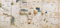
The Cantino planisphere
(1502) is possibly a copy of this official prototype. It is conjectured that Cantino was able to bribe a Portuguese government mapmaker to copy this map for him, between December 1501 and October 1502. From a letter signed by Cantino, it’s thought that he sent the map to Duke Ferrara on the 19th of November, 1502.
Portugal
Portugal , officially the Portuguese Republic is a country situated in southwestern Europe on the Iberian Peninsula. Portugal is the westernmost country of Europe, and is bordered by the Atlantic Ocean to the West and South and by Spain to the North and East. The Atlantic archipelagos of the...
map produced and maintained by the Portuguese government organization, the Casa da Índia
Casa da Índia
Casa da Índia was the Portuguese organization that managed all overseas territories during the heyday of the Portuguese Empire in the 16th century. It was both the central authority for managing all aspects of overseas trade, the central shipment point and clearing house...
, where the new discoveries made by the Portuguese were recorded in secret. The first Padrão Real was produced in the time of Henry the Navigator, before the Casa da Índia
Casa da Índia
Casa da Índia was the Portuguese organization that managed all overseas territories during the heyday of the Portuguese Empire in the 16th century. It was both the central authority for managing all aspects of overseas trade, the central shipment point and clearing house...
existed, but its predecessor organizations were already functioning.
Spain
Spain , officially the Kingdom of Spain languages]] under the European Charter for Regional or Minority Languages. In each of these, Spain's official name is as follows:;;;;;;), is a country and member state of the European Union located in southwestern Europe on the Iberian Peninsula...
secret master map known as the Padrón Real
Padrón Real
The Padrón Real , known after 2 August 1527 as the Padrón General , was the official and secret Spanish master map used as a template for the maps present on all Spanish ships during the 16th century. It was kept in Seville, Spain by the Casa de Contratación. Ship pilots were required to use a copy...
(later called the Padrón General) produced and managed by the Casa de Contratación
Casa de Contratación
La Casa de Contratación was a government agency under the Spanish Empire, existing from the 16th to the 18th centuries, which attempted to control all Spanish exploration and colonization...
.
The Cantino planisphere
Cantino planisphere
The Cantino planisphere is the earliest surviving map showing Portuguese Discoveries in the east and west. It is named after Alberto Cantino, an agent for the Duke of Ferrara, who successfully smuggled it from Portugal to Italy in 1502...
(1502) is possibly a copy of this official prototype. It is conjectured that Cantino was able to bribe a Portuguese government mapmaker to copy this map for him, between December 1501 and October 1502. From a letter signed by Cantino, it’s thought that he sent the map to Duke Ferrara on the 19th of November, 1502.