
Overseas Highway
Encyclopedia
The Overseas Highway is a 127.5 miles (205.2 km) highway carrying U.S. Route 1
(US 1) through the Florida Keys
. Large parts of it were built on the former right-of-way of the Overseas Railroad
, the Key West
Extension of the Florida East Coast Railway
. Completed in 1912, the Overseas Railroad was heavily damaged and partially destroyed in the Labor Day Hurricane of 1935
. The Florida East Coast Railway was financially unable to rebuild the destroyed sections, so the roadbed and remaining bridges were sold to the State of Florida
for $640,000.
The original construction of the Overseas Highway used many of the bridge
s of the former railroad, including truss bridge
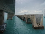
s, where the roadway was built on top of the trusses. Most of these older bridges built for railroads have been replaced by more modern bridges that are able to accommodate more than two lanes of traffic. The highway included the Seven Mile Bridge
, the Bahia Honda
Bridge and the Long Key
Bridge (although these three original bridges are no longer open to vehicular traffic, except for part of Seven Mile Bridge, they are listed on the National Register of Historic Places
and are currently used as fishing piers).
From its opening on March 29, 1938, until the destruction by fire of the Card Sound Bridge
in 1944, the Overseas Highway also had the signed designation State Road 4A; after the realignment in 1945 to its current entry onto Key Largo
along the old railroad right-of-way (the new segment of Overseas Highway, from Florida City
to Key Largo
is known locally as "the 18 Mile Stretch"), it received the unsigned designation State Road 5, the same as the entirety of US 1 south of Jacksonville
at that time.
Portions of the road were tolled
until April 15, 1954; toll booth
s were located on Big Pine Key and Lower Matecumbe Key
. Pigeon Key
, roughly the midway point of the Seven Mile Bridge, served as the headquarters for the "Overseas Road and Toll District." The toll for automobiles was $1, plus 25 cents per passenger.
One of animated television's Wacky Races
was The Overseas Hi-Way Race, which first aired on December 28, 1968, on CBS
, covering the entire actual route from Key Largo to Key West. While Long Key
was correctly portrayed, most of the other in-between keys were given fictional names, and Sombrero Key
was actually five miles south of the highway in open water, according to the Florida Keys
–East map.
The entire roadway of the Overseas Highway was substantially rebuilt in the 1980s. In recent years, Pigeon Key was used by the University of Miami
as an oceanography
laboratory
, but current efforts to restore the buildings on the island have resulted in the establishment of a railroad museum there. The newer Seven Mile Bridge does not have direct access to Pigeon Key; people going there must walk on 2.2 miles (3.5 km) of the original Seven Mile Bridge from its northern end on Knight's Key
, or take a shuttle bus, to reach the island.
(FDOT) maintains mile marker signs
every mile along the highway. Numbering starts in Key West, and increases towards the east and northeast up the path of the highway over the keys. Businesses along the highway began listing their locations by mile markers, adding decimal parts to more precisely indicate locations between mile marker signs. Outside of Key West and the City of Marathon
, street addresses along the highway are based on the mile markers, using a four- to six-digit number (with no decimal point); the numbering pattern is as follows:
As an example, the Tropical Research Laboratory of Mote Marine Laboratory
has a physical address of 24244 Overseas Highway. The first three digits indicate that it is near mile marker 24.2 (it is located on Summerland Key
) while the last two digits indicate that it is located on the Atlantic Ocean side of the highway.
, the Florida Department of Environmental Protection
's Office of Greenways and Trails, and FDOT entered into a Memorandum of understanding
to create the Florida Keys Overseas Heritage Trail
(FKOHT). The trail will be a world-class, multi-use bicycle and pedestrian facility that will traverse the Florida Keys from Key Largo to Key West. Upon completion, the FKOHT will include an integrated system of educational kiosks, roadside picnic areas, scenic overlooks, fishing piers, water access points, and bicycle and jogging paths. The development of the trail will provide a mechanism for the preservation and use of the historic Flagler Railroad Bridges, 23 of which still exist and are mostly intact. Several alternatives exist for trail alignment, including cutting down the 22 feet (6.7 m), 1940s-era roadway to its original 12 feet (3.7 m) spandrel width, or using the 22 feet (6.7 m) roadway as is, particularly in multi-use areas. In all cases, original bridgework will be repaired or rebuilt, and the breaks created during the 1980s and 1990s fishing pier conversion will be reconnected. Where the original roadway no longer exists, the trail will be temporarily cantilevered
on the side of the current US 1 highway bridge, until new 12 feet (3.7 m) trail bridge sections can be built. The new sections will be built to match the historical character of the original bridges.
U.S. Route 1 in Florida
U.S. Route 1 in Florida runs along the state's east coast from Key West to its crossing of the St. Marys River into Georgia north of Boulogne, and south of Folkston. US 1 was designated through Florida when the U.S. Highway System was established in 1926.US 1 runs in the state of Florida, and...
(US 1) through the Florida Keys
Florida Keys
The Florida Keys are a coral archipelago in southeast United States. They begin at the southeastern tip of the Florida peninsula, about south of Miami, and extend in a gentle arc south-southwest and then westward to Key West, the westernmost of the inhabited islands, and on to the uninhabited Dry...
. Large parts of it were built on the former right-of-way of the Overseas Railroad
Overseas Railroad
The Overseas Railroad was an extension of the Florida East Coast Railway to Key West, a city of almost 30,000 inhabitants located 128 miles beyond the end of the Florida peninsula...
, the Key West
Key West, Florida
Key West is a city in Monroe County, Florida, United States. The city encompasses the island of Key West, the part of Stock Island north of U.S. 1 , Sigsbee Park , Fleming Key , and Sunset Key...
Extension of the Florida East Coast Railway
Florida East Coast Railway
The Florida East Coast Railway is a Class II railroad operating in the U.S. state of Florida; in the past, it has been a Class I railroad.Built primarily in the last quarter of the 19th century and the first decade of the 20th century, the FEC was a project of Standard Oil principal Henry Morrison...
. Completed in 1912, the Overseas Railroad was heavily damaged and partially destroyed in the Labor Day Hurricane of 1935
Labor Day Hurricane of 1935
The 1935 Labor Day Hurricane was the strongest tropical cyclone of the 1935 Atlantic hurricane season, and one of the most intense hurricanes to make landfall in the United States in recorded history...
. The Florida East Coast Railway was financially unable to rebuild the destroyed sections, so the roadbed and remaining bridges were sold to the State of Florida
Florida
Florida is a state in the southeastern United States, located on the nation's Atlantic and Gulf coasts. It is bordered to the west by the Gulf of Mexico, to the north by Alabama and Georgia and to the east by the Atlantic Ocean. With a population of 18,801,310 as measured by the 2010 census, it...
for $640,000.
The original construction of the Overseas Highway used many of the bridge
Bridge
A bridge is a structure built to span physical obstacles such as a body of water, valley, or road, for the purpose of providing passage over the obstacle...
s of the former railroad, including truss bridge
Truss bridge
A truss bridge is a bridge composed of connected elements which may be stressed from tension, compression, or sometimes both in response to dynamic loads. Truss bridges are one of the oldest types of modern bridges...
s, where the roadway was built on top of the trusses. Most of these older bridges built for railroads have been replaced by more modern bridges that are able to accommodate more than two lanes of traffic. The highway included the Seven Mile Bridge
Seven Mile Bridge
The Seven Mile Bridge is a famous bridge in the Florida Keys, in Monroe County, Florida, United States. It connects Knight's Key in the Middle Keys to Little Duck Key in the Lower Keys...
, the Bahia Honda
Bahia Honda Key
Bahia Honda , is an island in the lower Florida Keys.U.S...
Bridge and the Long Key
Long Key
Long Key is an island in the middle Florida Keys.U.S. 1 crosses the key at approximately mile markers 65.5--71, between Fiesta Key and Conch Key....
Bridge (although these three original bridges are no longer open to vehicular traffic, except for part of Seven Mile Bridge, they are listed on the National Register of Historic Places
National Register of Historic Places
The National Register of Historic Places is the United States government's official list of districts, sites, buildings, structures, and objects deemed worthy of preservation...
and are currently used as fishing piers).
From its opening on March 29, 1938, until the destruction by fire of the Card Sound Bridge
Card Sound Bridge
Card Sound Bridge is a high-rise toll causeway connecting southern Miami-Dade County and northern Monroe County. It is one of only two ways that motorists can leave or enter the Florida Keys . Toll for two-axle automobiles is USD $1.00 , and SunPass is not accepted at this toll plaza...
in 1944, the Overseas Highway also had the signed designation State Road 4A; after the realignment in 1945 to its current entry onto Key Largo
Key Largo
Key Largo is an island in the upper Florida Keys archipelago and, at long, the largest of the Keys. It is also the northernmost of the Florida Keys in Monroe County, and the northernmost of the Keys connected by U.S. Highway 1...
along the old railroad right-of-way (the new segment of Overseas Highway, from Florida City
Florida City, Florida
Florida City is a city in Miami-Dade County, Florida, United States and is the southernmost municipality in the South Florida metropolitan area, which had an estimated population of 5,413,212 in 2007. The population was 7,843 at the 2000 census. As of 2004, the population estimated by the U.S....
to Key Largo
Key Largo, Florida
Key Largo is a census-designated place in Monroe County, Florida, United States, located on the island of Key Largo in the upper Florida Keys. The population was 11,886 at the 2000 census. The name comes from the Spanish Cayo Largo, or "long key"...
is known locally as "the 18 Mile Stretch"), it received the unsigned designation State Road 5, the same as the entirety of US 1 south of Jacksonville
Jacksonville, Florida
Jacksonville is the largest city in the U.S. state of Florida in terms of both population and land area, and the largest city by area in the contiguous United States. It is the county seat of Duval County, with which the city government consolidated in 1968...
at that time.
Portions of the road were tolled
Toll road
A toll road is a privately or publicly built road for which a driver pays a toll for use. Structures for which tolls are charged include toll bridges and toll tunnels. Non-toll roads are financed using other sources of revenue, most typically fuel tax or general tax funds...
until April 15, 1954; toll booth
Toll house
A tollhouse or toll house is a building with accommodation for a toll collector, beside a tollgate on a toll road or canal. Many tollhouses were built by turnpike trusts in England, Wales and Scotland during the 18th and early 19th centuries...
s were located on Big Pine Key and Lower Matecumbe Key
Lower Matecumbe Key
Lower Matecumbe Key is an island in the upper Florida Keys.It is located on U.S. 1 between mile markers 75--78.All of the key is within the Village of Islamorada as of November 4, 1997, when it was incorporated....
. Pigeon Key
Pigeon Key
Pigeon Key is a historic district located on the small island of Pigeon Key in the lower Florida Keys. The island is named "Cayo Paloma" on many old Spanish charts...
, roughly the midway point of the Seven Mile Bridge, served as the headquarters for the "Overseas Road and Toll District." The toll for automobiles was $1, plus 25 cents per passenger.
One of animated television's Wacky Races
Wacky Races
Wacky Races is an animated television series produced by Hanna-Barbera. The series features 11 different cars racing against each other in various road rallies throughout North America, with each driver hoping to win the title of the "World's Wackiest Racer." Wacky Races ran on CBS from September...
was The Overseas Hi-Way Race, which first aired on December 28, 1968, on CBS
CBS
CBS Broadcasting Inc. is a major US commercial broadcasting television network, which started as a radio network. The name is derived from the initials of the network's former name, Columbia Broadcasting System. The network is sometimes referred to as the "Eye Network" in reference to the shape of...
, covering the entire actual route from Key Largo to Key West. While Long Key
Long Key
Long Key is an island in the middle Florida Keys.U.S. 1 crosses the key at approximately mile markers 65.5--71, between Fiesta Key and Conch Key....
was correctly portrayed, most of the other in-between keys were given fictional names, and Sombrero Key
Sombrero Key (reef)
Sombrero Key is a coral reef located within the Florida Keys National Marine Sanctuary. It lies to the south of Vaca Key. This reef lies within a Sanctuary Preservation Area ....
was actually five miles south of the highway in open water, according to the Florida Keys
Florida Keys
The Florida Keys are a coral archipelago in southeast United States. They begin at the southeastern tip of the Florida peninsula, about south of Miami, and extend in a gentle arc south-southwest and then westward to Key West, the westernmost of the inhabited islands, and on to the uninhabited Dry...
–East map.
The entire roadway of the Overseas Highway was substantially rebuilt in the 1980s. In recent years, Pigeon Key was used by the University of Miami
University of Miami
The University of Miami is a private, non-sectarian university founded in 1925 with its main campus in Coral Gables, Florida, a medical campus in Miami city proper at Civic Center, and an oceanographic research facility on Virginia Key., the university currently enrolls 15,629 students in 12...
as an oceanography
Oceanography
Oceanography , also called oceanology or marine science, is the branch of Earth science that studies the ocean...
laboratory
Laboratory
A laboratory is a facility that provides controlled conditions in which scientific research, experiments, and measurement may be performed. The title of laboratory is also used for certain other facilities where the processes or equipment used are similar to those in scientific laboratories...
, but current efforts to restore the buildings on the island have resulted in the establishment of a railroad museum there. The newer Seven Mile Bridge does not have direct access to Pigeon Key; people going there must walk on 2.2 miles (3.5 km) of the original Seven Mile Bridge from its northern end on Knight's Key
Knight's Key
Knight's Key is an island in the middle Florida Keys, located entirely within the borders of the city of Marathon, Florida.-Geography:U.S. 1 crosses the key at approximately mile marker 47, at the western end of Key Vaca and eastern end of the Seven Mile Bridge.-History:Prior to the completion of...
, or take a shuttle bus, to reach the island.
Mile markers
Locations along the Overseas Highway from Key West to Key Largo are commonly given as mile markers. The Florida Department of TransportationFlorida Department of Transportation
The Florida Department of Transportation is a decentralized agency charged with the establishment, maintenance, and regulation of public transportation in the state of Florida. The department was formed in 1969. It absorbed the powers of the Florida State Road Department...
(FDOT) maintains mile marker signs
Milestone
A milestone is one of a series of numbered markers placed along a road or boundary at intervals of one mile or occasionally, parts of a mile. They are typically located at the side of the road or in a median. They are alternatively known as mile markers, mileposts or mile posts...
every mile along the highway. Numbering starts in Key West, and increases towards the east and northeast up the path of the highway over the keys. Businesses along the highway began listing their locations by mile markers, adding decimal parts to more precisely indicate locations between mile marker signs. Outside of Key West and the City of Marathon
Marathon, Florida
Marathon is a city on Knight's Key, Boot Key, Key Vaca, Fat Deer Key, Long Point Key, Crawl Key and Grassy Key islands in the middle Florida Keys, in Monroe County, Florida, in the United States. As of the 2000 census, the city had a total population of 10,255. As of 2005, the population estimated...
, street addresses along the highway are based on the mile markers, using a four- to six-digit number (with no decimal point); the numbering pattern is as follows:
- The first three (or four) digits denote the approximate mile marker
- The last two digits denote a particular address; an even digit denotes an address on the Atlantic Ocean side while an odd digit denotes an address on the Florida Bay/Gulf of Mexico side
As an example, the Tropical Research Laboratory of Mote Marine Laboratory
Mote Marine Laboratory
Mote Marine Laboratory is an independent not-for-profit marine research organization based on City Island in Sarasota, FL. The laboratory aims to advance the science of the sea, both through its marine and estuarine research labs and through the public Mote Aquarium and its affiliated educational...
has a physical address of 24244 Overseas Highway. The first three digits indicate that it is near mile marker 24.2 (it is located on Summerland Key
Summerland Key
Summerland Key is an island in the lower Florida Keys approximately 20 miles east of Key West.U.S. 1 crosses the island at approximately mile markers 24—25.5, between Ramrod Key and Cudjoe Key. The name appears on U.S...
) while the last two digits indicate that it is located on the Atlantic Ocean side of the highway.
Trail
In 2001, the Monroe County CommissionMonroe County, Florida
Monroe County is a county located in the state of Florida. As of 2000, the population was 79,589. The U.S. Census Bureau 2006 estimate for the county was 74,737....
, the Florida Department of Environmental Protection
Florida Department of Environmental Protection
The Florida Department of Environmental Protection is the Florida government agency charged with environmental protection.-History:...
's Office of Greenways and Trails, and FDOT entered into a Memorandum of understanding
Memorandum of understanding
A memorandum of understanding is a document describing a bilateral or multilateral agreement between parties. It expresses a convergence of will between the parties, indicating an intended common line of action. It is often used in cases where parties either do not imply a legal commitment or in...
to create the Florida Keys Overseas Heritage Trail
Florida Keys Overseas Heritage Trail
The Florida Keys Overseas Heritage Trail is a pedestrian and cycling trail currently in development in the Florida Keys. There currently exist 60 miles of trail included in the project with 40 additional miles planned for development. The eventual vision for the trail is to span from the island...
(FKOHT). The trail will be a world-class, multi-use bicycle and pedestrian facility that will traverse the Florida Keys from Key Largo to Key West. Upon completion, the FKOHT will include an integrated system of educational kiosks, roadside picnic areas, scenic overlooks, fishing piers, water access points, and bicycle and jogging paths. The development of the trail will provide a mechanism for the preservation and use of the historic Flagler Railroad Bridges, 23 of which still exist and are mostly intact. Several alternatives exist for trail alignment, including cutting down the 22 feet (6.7 m), 1940s-era roadway to its original 12 feet (3.7 m) spandrel width, or using the 22 feet (6.7 m) roadway as is, particularly in multi-use areas. In all cases, original bridgework will be repaired or rebuilt, and the breaks created during the 1980s and 1990s fishing pier conversion will be reconnected. Where the original roadway no longer exists, the trail will be temporarily cantilevered
Cantilever bridge
A cantilever bridge is a bridge built using cantilevers, structures that project horizontally into space, supported on only one end. For small footbridges, the cantilevers may be simple beams; however, large cantilever bridges designed to handle road or rail traffic use trusses built from...
on the side of the current US 1 highway bridge, until new 12 feet (3.7 m) trail bridge sections can be built. The new sections will be built to match the historical character of the original bridges.