

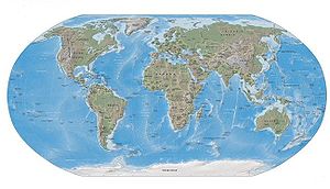
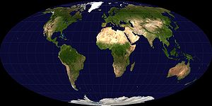
Outline of geography
Encyclopedia
The following outline is provided as an overview of and topical guide to geography:
Geography
– science that studies the lands, features, inhabitants, and phenomena of Earth.
- geographia, lit. "earth describe-write"
Other branches include:
All the branches are further described below...
– study of world regions. Attention is paid to unique characteristics of a particular region such as its natural elements, human elements, and regionalization which covers the techniques of delineating space into regions. Regional geography breaks down into the study of specific regions.
Region
– an area, defined by physical characteristics, human characteristics, or functional characteristics. The term is used in various ways among the different branches of geography. A region can be seen as a collection of smaller units, such as a country and its political divisions, or as one part of a larger whole, as in a country on a continent.
A supercontinent is a landmass
comprising more than one continent
al core, or craton
.
es on Earth
. They are generally identified by convention
rather than any specific criteria, but seven areas are commonly regarded as continents. They are:
(outline
) – 2. Antarctica – 3. Australia
(outline) – The Americas:
4. North America
(outline) – 5. South America
(outline) – Eurasia:
6. Europe
(outline) – 7. Asia
(outline
) –
The World Wildlife Fund (WWF) developed a system of eight biogeographic realms (ecozones):
Ecozones are further divided into ecoregions. The World has over 800 terrestrial ecoregions. See Lists of ecoregions by country.
>

Topics pertaining to the geographical study of the World throughout history:
– component of a planet that can be referred to as a location, place, site, area, or region, and therefore may show up on a map. A geographic feature may be natural or man-made.
Ecosystem
–
 Natural landform
– terrain or body of water. Landforms are topographical elements, and are defined by their surface form and location in the landscape. Landforms are categorized by traits such as elevation, slope, orientation, stratification
, rock exposure, and soil type. Some landforms are man-made, such as artificial islands, but most landforms are natural.
 Some awards and competitions in the field of geography:
is a scientist
who studies Earth
's physical environment
and human
habitat
. Geographers are historically known for making map
s, the subdiscipline of geography known as cartography
. They study the physical details of the environment and also its impact on human and wildlife
ecologies
, weather
and climate
patterns, economics
, and culture
. Geographers focus on the spatial relationships between these elements.
Geography
Geography
Geography is the science that studies the lands, features, inhabitants, and phenomena of Earth. A literal translation would be "to describe or write about the Earth". The first person to use the word "geography" was Eratosthenes...
– science that studies the lands, features, inhabitants, and phenomena of Earth.
Geography is
- an academic disciplineAcademic disciplineAn academic discipline, or field of study, is a branch of knowledge that is taught and researched at the college or university level. Disciplines are defined , and recognized by the academic journals in which research is published, and the learned societies and academic departments or faculties to...
– a body of knowledge given to - or received by - a disciple (student); a branch or sphere of knowledge, or field of study, that an individual has chosen to specialise in. Modern geography is an all-encompassing discipline that seeks to understand the Earth and all of its human and natural complexities—not merely where objects are, but how they have changed and come to be. Geography has been called 'the world discipline'. - a field of science – widely-recognized category of specialized expertise within science, and typically embodies its own terminology and nomenclature. Such a field will usually be represented by one or more scientific journals, where peer reviewed research is published. There are many geography-related scientific journals.
- a natural scienceNatural scienceThe natural sciences are branches of science that seek to elucidate the rules that govern the natural world by using empirical and scientific methods...
– field of academic scholarship that explores aspects of natural environment (physical geography). - a social science – field of academic scholarship that explores aspects of human society (human geography).
- a natural science
- an interdisciplinary field – a field that crosses traditional boundaries between academic disciplines or schools of thought, as new needs and professions have emerged. Many of the branches of physical geography are also branches of Earth science.
Etymology of geography
Etymology of "geography": from GreekGreek language
Greek is an independent branch of the Indo-European family of languages. Native to the southern Balkans, it has the longest documented history of any Indo-European language, spanning 34 centuries of written records. Its writing system has been the Greek alphabet for the majority of its history;...
- geographia, lit. "earth describe-write"
- geo- – a prefix taken from the Greek word γη or γαια meaning "earth", usually in the sense of "ground or land". Geo- is a prefix for many words dealing in some way with the earth.
- -graphy-graphy-graphy is an English suffix. Words that include the suffix usually are about a work, an art, or a field of study.- Etymology :The English suffix -graphy means either "writing" or a "field of study", and is an anglicization of the French -graphie inherited from the Latin -graphia, which is a...
– an English suffix. Words that include this suffix usually are about a work, an art, or a field of study.
Branches of geography
As "the bridge between the human and physical sciences," geography is divided into two main branches:- human geography
- physical geography
Other branches include:
- integrated geography
- geomatics
- regional geography
All the branches are further described below...
Physical geography
- Physical geographyPhysical geographyPhysical geography is one of the two major subfields of geography. Physical geography is that branch of natural science which deals with the study of processes and patterns in the natural environment like the atmosphere, biosphere and geosphere, as opposed to the cultural or built environment, the...
– examines the natural environment and how the climate, vegetation & life, soil, water, and landforms are produced and interact.
Fields of physical geography
- GeomorphologyGeomorphologyGeomorphology is the scientific study of landforms and the processes that shape them...
– study of landforms and the processes that shape them, and more broadly, the evolution of processes controlling the topography of any planet. Seeks to understand why landscapes look the way they do, to understand landform history and dynamics, and to predict future changes through a combination of field observation, physical experiment, and numerical modeling. - HydrologyHydrologyHydrology is the study of the movement, distribution, and quality of water on Earth and other planets, including the hydrologic cycle, water resources and environmental watershed sustainability...
– study of the movement, distribution, and quality of water throughout the Earth, including the hydrologic cycle, water resources and environmental watershed sustainability.- GlaciologyGlaciologyGlaciology Glaciology Glaciology (from Middle French dialect (Franco-Provençal): glace, "ice"; or Latin: glacies, "frost, ice"; and Greek: λόγος, logos, "speech" lit...
– study of glaciers, or more generally ice and natural phenomena that involve ice. - OceanographyOceanographyOceanography , also called oceanology or marine science, is the branch of Earth science that studies the ocean...
– studies a wide range of topics pertaining to oceans, including marine organisms and ecosystem dynamics; ocean currents, waves, and geophysical fluid dynamics; plate tectonics and the geology of the sea floor; and fluxes of various chemical substances and physical properties within the ocean and across its boundaries.
- Glaciology
- BiogeographyBiogeographyBiogeography is the study of the distribution of species , organisms, and ecosystems in space and through geological time. Organisms and biological communities vary in a highly regular fashion along geographic gradients of latitude, elevation, isolation and habitat area...
– study of the distribution of species spatially and temporally. Over areal ecologicalEcologyEcology is the scientific study of the relations that living organisms have with respect to each other and their natural environment. Variables of interest to ecologists include the composition, distribution, amount , number, and changing states of organisms within and among ecosystems...
changes, it is also tied to the concepts of species and their past, or present living 'refugium', their survival locales, or their interim living sites. It aims to reveal where organisms live, and at what abundance. - ClimatologyClimatologyClimatology is the study of climate, scientifically defined as weather conditions averaged over a period of time, and is a branch of the atmospheric sciences...
– study of climateClimateClimate encompasses the statistics of temperature, humidity, atmospheric pressure, wind, rainfall, atmospheric particle count and other meteorological elemental measurements in a given region over long periods...
, scientifically defined as weather conditions averaged over a period of timeTimeTime is a part of the measuring system used to sequence events, to compare the durations of events and the intervals between them, and to quantify rates of change such as the motions of objects....
. - MeteorologyMeteorologyMeteorology is the interdisciplinary scientific study of the atmosphere. Studies in the field stretch back millennia, though significant progress in meteorology did not occur until the 18th century. The 19th century saw breakthroughs occur after observing networks developed across several countries...
is the interdisciplinary scientific study of the atmosphere that focuses on weather processes and short term forecasting (in contrast with climatology). - PedologyPedology (soil study)Pedology is the study of soils in their natural environment. It is one of two main branches of soil science, the other being edaphology...
– study of soils in their natural environment that deals with pedogenesisPedogenesisPedogenesis is the science and study of the processes that lead to the formation of soil ' and first explored by the Russian geologist Vasily Dokuchaev , the so called grandfather of soil science, who determined that soil formed over time as a consequence of...
, soil morphologySoil morphologySoil morphology is the field observable attributes of the soil within the various soil horizons and the description of the kind and arrangement of the horizons. C.F...
, and soil classificationSoil classificationSoil classification deals with the systematic categorization of soils based on distinguishing characteristics as well as criteria that dictate choices in use.- Overview :...
. - PalaeogeographyPalaeogeographyPalaeogeography is the study of what the geography was in times past. It is most often used about the physical landscape, although nothing excludes its use in reference to the human or cultural environment...
– study of what the geography was in times past, most often concerning the physical landscape, but also the human or cultural environment. - Coastal geographyCoastal geographyCoastal geography is the study of the dynamic interface between the ocean and the land, incorporating both the physical geography and the human geography of the coast...
– study of the dynamic interface between the ocean and the land, incorporating both the physical geography (i.e. coastal geomorphology, geology and oceanography) and the human geography (sociology and history) of the coast. It involves an understanding of coastal weathering processes, particularly wave action, sediment movement and weather, and also the ways in which humans interact with the coast. - Quaternary scienceQuaternary scienceQuaternary science is an inter-disciplinary field of study focusing on the Quaternary period, which encompasses the last 2.6 million years. The field studies the last ice age and the recent interstadial the Holocene and uses proxy evidence to reconstruct the past environments during this period to...
– focuses on the Quaternary period, which encompasses the last 2.6 million years, including the last ice age and the Holocene period. - Landscape ecologyLandscape ecologyLandscape ecology is the science of studying and improving relationships between urban development and ecological processes in the environment and particular ecosystems...
– the relationship between spatial patterns of urban development and ecological processes on a multitude of landscape scales and organisational levels.
Approaches of physical geography
- Quantitative geography – Quantitative researchQuantitative researchIn the social sciences, quantitative research refers to the systematic empirical investigation of social phenomena via statistical, mathematical or computational techniques. The objective of quantitative research is to develop and employ mathematical models, theories and/or hypotheses pertaining to...
tools and methods applied to geography. See also the quantitative revolutionQuantitative revolutionIn the history of geography, the quantitative revolution [n] was one of the four major turning-points of modern geography -- the other three being environmental determinism, regional geography and critical geography)...
. - Systems approach –
Human geography
- Human geographyHuman geographyHuman geography is one of the two major sub-fields of the discipline of geography. Human geography is the study of the world, its people, communities, and cultures. Human geography differs from physical geography mainly in that it has a greater focus on studying human activities and is more...
– one of the two main subfields of geography, it is the study of human use and understanding of the world and the processes which have affected it. Human geography broadly differs from physical geography in that it focuses on the built environmentBuilt environmentThe term built environment refers to the human-made surroundings that provide the setting for human activity, ranging in scale from personal shelter and buildings to neighborhoods and cities that can often include their supporting infrastructure, such as water supply or energy networks.The built...
and how space is created, viewed, and managed by humans as well as the influence humans have on the space they occupy.
Fields of human geography
- Cultural geographyCultural geographyCultural geography is a sub-field within human geography. Cultural geography is the study of cultural products and norms and their variations across and relations to spaces and places...
– study of cultural products and norms and their variations across and relations to spaces and places. It focuses on describing and analyzing the ways language, religion, economy, government and other cultural phenomena vary or remain constant, from one place to another and on explaining how humans function spatially.- Children's geographiesChildren's geographiesChildren's geographies is an area of study within human geography and Childhood Studies which involves researching the places and spaces of children's lives....
– study of places and spaces of children's lives, characterised experientially, politically and ethically. Children's geographies rests on the idea that children as a social group share certain characteristics which are experientially, politically and ethically significant and which are worthy of study. The pluralisation in the title is intended to imply that children's lives will be markedly different in differing times and places and in differing circumstances such as gender, family, and class. The range of focii within children's geographies include:- Children and the city
- Children and the countryside
- Children and technology
- Children and nature,
- Children and globalisation
- Methodologies of researching children's worlds
- Ethics of researching children's worlds
- Otherness of childhoodOtherness of childhoodThe otherness of childhood is a phrase being used to argue that there are substantial differences between the lived worlds of children and adults. These differences are suggested to emerge from complex outcomes of divergent states of physical, neurological, emotional, affective and experiential...
- Animal geographiesAnimal geographiesAnimal geographies is an area of study in geography, studying the spaces and places occupied by animals in human culture.An interest in animal geographies emerged in human geography in the mid 1990s...
– studies the spaces and places occupied by animals in human culture, because social life and space is heavily populated by animals of many differing kinds and in many differing ways (e.g. farm animals, pets, wild animals in the city). Another impetus that has influenced the development of the field are ecofeminist and other environmentalist viewpoints on nature-society relations (including questions of animal welfare and rights). - Language geographyLanguage geographyLanguage geography is the branch of human geography that studies the geographic distribution of language or its constituent elements. There are two principal fields of study within the geography of language: the "geography of languages", which deals with the distribution through history and space...
– studies the geographic distribution of language or its constituent elements. There are two principal fields of study within the geography of language:- Geography of languages – deals with the distribution through history and space of languages,
- Linguistic geography – deals with regional linguistic variations within languages.
- Sexuality and spaceSexuality and spaceSexuality and space is a field of study within human geography. The phrase encompasses all relationships and interactions between human sexuality, space and place, themes studied within, but not limited to cultural geography, i.e...
– encompasses all relationships and interactions between human sexuality, space, and place, including the geographies of LGBT residence, public sex environments, sites of queer resistance, global sexualities, sex tourism, the geographies of prostitution and adult entertainment, use of sexualised locations in the arts, and sexual citizenship. - Religion geographyReligion geographyReligion and geography is the study of the impact of geography, i.e. place and space, on religious belief.Another aspect of the relationship between religion and geography is religious geography, in which geographical ideas are influenced by religion, such as early map-making, and the biblical...
– study of the impact of geography, i.e. place and space, on religious belief.
- Children's geographies
- Development geographyDevelopment geographyDevelopment geography is the study of the earth's geography with reference to the standard of living and quality of life of its human inhabitants. In this context, development is a process of change that affects people's lives. It may involve an improvement in the quality of life as perceived by...
– study of the Earth's geography with reference to the standard of living and quality of life of its human inhabitants. Measures development by looking at economic, political and social factors, and seeks to understand both the geographical causes and consequences of varying development, in part by comparing More Economically Developed Countries (MEDCs) with Less Economically Developed Countries (LEDCs). - Economic geographyEconomic geographyEconomic geography is the study of the location, distribution and spatial organization of economic activities across the world. The subject matter investigated is strongly influenced by the researcher's methodological approach. Neoclassical location theorists, following in the tradition of Alfred...
– study of the location, distribution and spatial organization of economic activities across the world. Subjects of interest include but are not limited to the location of industries, economies of agglomeration (also known as "linkages"), transportation, international trade and development, real estate, gentrification, ethnic economies, gendered economies, core-periphery theory, the economics of urban form, the relationship between the environment and the economy (tying into a long history of geographers studying culture-environment interaction), and globalization.- Marketing geography – a discipline within marketing analysis which uses geolocation (geographic information) in the process of planning and implementation of marketing activities. It can be used in any aspect of the marketing mix – the product, price, promotion, or place (geo targeting).
- Transportation geographyTransportation geographyTransportation Geography, also Transport Geography, is the branch of geography that investigates spatial interactions, let them be of people, freight and information. It can consider humans and their use of vehicles or other modes of travelling as well as how markets are serviced by flows of...
– branch of economic geography that investigates spatial interactions between people, freight and information. It studies humans and their use of vehicles or other modes of travelling as well as how markets are serviced by flows of finished goods and raw materials.
- Health geographyHealth geographyHealth geography is the application of geographical information, perspectives, and methods to the study of health, disease, and health care.- Overview :...
– application of geographical information, perspectives, and methods to the study of health, disease, and health care, to provide a spatial understanding of a population's health, the distribution of disease in an area, and the environment's effect on health and disease. It also deals with accessibility to health care and spatial distribution of health care providers.- Time geographyTime geographyTime geography or time-space geography traces its roots back to the Swedish geographer Torsten Hägerstrand who stressed the temporal factor in spatial human activities. The time-space path, devised by Hägerstrand, shows the movement of an individual in the spatial-temporal environment with the...
– study of the temporal factor on spatial human activities within the following constraints:
- Time geography
- Authority - limits of accessibility to certain places or domains placed on individuals by owners or authorities
- Capability - limitations on the movement of individuals, based on their nature. For example, movement is restricted by biological factors, such as the need for food, drink, and sleep
- Coupling - restraint of an individual, anchoring him or her to a location while interacting with other individuals in order to complete a task
- Historical geographyHistorical geographyHistorical geography is the study of the human, physical, fictional, theoretical, and "real" geographies of the past. Historical geography studies a wide variety of issues and topics. A common theme is the study of the geographies of the past and how a place or region changes through time...
– study of the human, physical, fictional, theoretical, and "real" geographies of the past, and seeks to determine how cultural features of various societies across the planet emerged and evolved, by understanding how a place or region changes through time, including how people have interacted with their environment and created the cultural landscape. - Political geographyPolitical geographyPolitical geography is the field of human geography that is concerned with the study of both the spatially uneven outcomes of political processes and the ways in which political processes are themselves affected by spatial structures...
– study of the spatially uneven outcomes of political processes and the ways in which political processes are themselves affected by spatial structures. Basically, the inter-relationships between people, state, and territory.- Electoral geographyElectoral geographyElectoral Geography is the analysis of the methods, behavior, and results of elections in the context of geographic space and using geographical techniques. Specifically, it is an examination of the dual interaction whereby geographical traits of a territory affects political decisions and...
– study of the relationship between election results and the regions they affect (such as the environmental impact of voting decisions), and of the effects of regional factors upon voting behavior. - GeopoliticsGeopoliticsGeopolitics, from Greek Γη and Πολιτική in broad terms, is a theory that describes the relation between politics and territory whether on local or international scale....
– analysis of geography, history and social science with reference to spatial politics and patterns at various scales, ranging from the level of the state to international. - Strategic geographyStrategic geographyStrategic geography is concerned with the control of, or access to, spatial areas that have an impact on the security and prosperity of nations. Spatial areas that concern strategic geography change with human needs and development. This field is a subset of human geography, itself a subset of the...
– concerned with the control of, or access to, spatial areas that have an impact on the security and prosperity of nations. - Military geographyMilitary geographyMilitary geography is a sub-field of geography that is used by, not only the military, but also academics and politicians to understand the geopolitical sphere through the militaristic lens...
– the application of geographic tools, information, and techniques to solve military problems in peacetime or war.
- Electoral geography
- Population geographyPopulation geographyPopulation geography is a division of human geography. It is the study of the ways in which spatial variations in the distribution, composition, migration, and growth of populations are related to the nature of places. Population geography involves demography in a geographical perspective. It...
– study of the ways in which spatial variations in the distribution, composition, migration, and growth of populations are related to the nature of places. - Tourism geographyTourism geographyTourism Geography is the study of travel and tourism, as an industry and as a social and cultural activity. Tourism geography covers a wide range of interests including the environmental impact of tourism, the geographies of tourism and leisure economies, answering tourism industry and management...
– study of travel and tourism, as an industry and as a social and cultural activity, and their impact on places, including the environmental impact of tourism, the geographies of tourism and leisure economies, answering tourism industry and management concerns and the sociology of tourism and locations of tourism. - Urban geographyUrban geographyUrban geography is the study of areas which have a high concentration of buildings and infrastructure. These are areas where the majority of economic activities are in the secondary sector and tertiary sectors...
– the study of urban areas, in terms of concentration, infrastructure, economy, and environmental impacts.
- Historical geography
Approaches of human geography
- Behavioral geographyBehavioral geographyBehavioral geography is an approach to human geography that examines human behavior using a disaggregate approach. Behavioral geographers focus on the cognitive processes underlying spatial reasoning, decision making, and behavior...
– - Critical geographyCritical geographyCritical geography takes a critical theory approach to the study and analysis of geography. The development of critical geography can be seen as one of the four major turning points in the history of geography...
– - Feminist geographyFeminist geographyFeminist geography is an approach in human geography which applies the theories, methods and critiques of feminism to the study of the human environment, society and geographical space.-Areas of study:...
– - Marxist geographyMarxist geographyMarxist geography is a critical geography which utilises the theories and philosophy of Marxism to examine the spatial relations of human geography. In Marxist geography the relations that geography has traditionally analyzed - natural environment and spatial relations - are reviewed as outcomes of...
– - Non-representational theoryNon-representational theoryNon-representational theory is a theory developed in human geography, largely through the work of Nigel Thrift , and his colleagues such as J.D. Dewsbury . It challenges those using social theory and conducting geographical research to go beyond representation...
– - PostcolonialismPostcolonialismPost-colonialism is a specifically post-modern intellectual discourse that consists of reactions to, and analysis of, the cultural legacy of colonialism...
– - Post-structuralismPost-structuralismPost-structuralism is a label formulated by American academics to denote the heterogeneous works of a series of French intellectuals who came to international prominence in the 1960s and '70s...
– - Qualitative geography – qualitative researchQualitative researchQualitative research is a method of inquiry employed in many different academic disciplines, traditionally in the social sciences, but also in market research and further contexts. Qualitative researchers aim to gather an in-depth understanding of human behavior and the reasons that govern such...
tools and methods applied to geography.
Integrated geography
- Integrated geography – branch of geography that describes the spatial aspects of interactions between humans and the natural world. It requires an understanding of the dynamics of geology, meteorology, hydrology, biogeography, ecology, and geomorphology, as well as the ways in which human societies conceptualize the environment.
Geomatics
- GeomaticsGeomaticsGeomatics is the discipline of gathering, storing, processing, and delivering geographic information, or spatially referenced information.-Overview and etymology:...
– branch of geography and the discipline of gathering, storing, processing, and delivering geographic information, or spatially referenced information. It is a widespread interdisciplinary field that includes the tools and techniques used in land surveying, remote sensing, cartography, Geographic Information Systems (GIS), Global Navigation Satellite Systems, photogrammetry, and related forms of earth mapping.
Fields contributing to geomatics
- PhotogrammetryPhotogrammetryPhotogrammetry is the practice of determining the geometric properties of objects from photographic images. Photogrammetry is as old as modern photography and can be dated to the mid-nineteenth century....
– - CartographyCartographyCartography is the study and practice of making maps. Combining science, aesthetics, and technique, cartography builds on the premise that reality can be modeled in ways that communicate spatial information effectively.The fundamental problems of traditional cartography are to:*Set the map's...
– - Digital terrain modelling –
- GeodesyGeodesyGeodesy , also named geodetics, a branch of earth sciences, is the scientific discipline that deals with the measurement and representation of the Earth, including its gravitational field, in a three-dimensional time-varying space. Geodesists also study geodynamical phenomena such as crustal...
– - Geographic information systemGeographic Information SystemA geographic information system, geographical information science, or geospatial information studies is a system designed to capture, store, manipulate, analyze, manage, and present all types of geographically referenced data...
s – - GeospatialGeospatialGeospatial analysis is an approach to applying statistical analysis and other informational techniques to geographically based data. Such analysis employs spatial software and analytical methods with terrestrial or geographic datasets, including geographic information systems and...
– - Global navigation satellite systemGlobal Navigation Satellite SystemA satellite navigation or SAT NAV system is a system of satellites that provide autonomous geo-spatial positioning with global coverage. It allows small electronic receivers to determine their location to within a few metres using time signals transmitted along a line-of-sight by radio from...
s – (GPS, GLONASS, GALILEO, COMPASS) - Global Positioning SystemGlobal Positioning SystemThe Global Positioning System is a space-based global navigation satellite system that provides location and time information in all weather, anywhere on or near the Earth, where there is an unobstructed line of sight to four or more GPS satellites...
– - HydrographyHydrographyHydrography is the measurement of the depths, the tides and currents of a body of water and establishment of the sea, river or lake bed topography and morphology. Normally and historically for the purpose of charting a body of water for the safe navigation of shipping...
– - MathematicsMathematicsMathematics is the study of quantity, space, structure, and change. Mathematicians seek out patterns and formulate new conjectures. Mathematicians resolve the truth or falsity of conjectures by mathematical proofs, which are arguments sufficient to convince other mathematicians of their validity...
– - NavigationNavigationNavigation is the process of monitoring and controlling the movement of a craft or vehicle from one place to another. It is also the term of art used for the specialized knowledge used by navigators to perform navigation tasks...
– - PhotogrammetryPhotogrammetryPhotogrammetry is the practice of determining the geometric properties of objects from photographic images. Photogrammetry is as old as modern photography and can be dated to the mid-nineteenth century....
– - Remote sensingRemote sensingRemote sensing is the acquisition of information about an object or phenomenon, without making physical contact with the object. In modern usage, the term generally refers to the use of aerial sensor technologies to detect and classify objects on Earth by means of propagated signals Remote sensing...
– - SurveyingSurveyingSee Also: Public Land Survey SystemSurveying or land surveying is the technique, profession, and science of accurately determining the terrestrial or three-dimensional position of points and the distances and angles between them...
–
Regional geography
Regional geographyRegional geography
Regional geography is the study of world regions. Attention is paid to unique characteristics of a particular region such as natural elements, human elements, and regionalization which covers the techniques of delineating space into regions....
– study of world regions. Attention is paid to unique characteristics of a particular region such as its natural elements, human elements, and regionalization which covers the techniques of delineating space into regions. Regional geography breaks down into the study of specific regions.
Region
Region
Region is most commonly found as a term used in terrestrial and astrophysics sciences also an area, notably among the different sub-disciplines of geography, studied by regional geographers. Regions consist of subregions that contain clusters of like areas that are distinctive by their uniformity...
– an area, defined by physical characteristics, human characteristics, or functional characteristics. The term is used in various ways among the different branches of geography. A region can be seen as a collection of smaller units, such as a country and its political divisions, or as one part of a larger whole, as in a country on a continent.
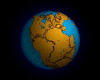
Supercontinents
- Main article: List of supercontinents
A supercontinent is a landmass
Landmass
A landmass is a contiguous area of land surrounded by ocean. Although it may be most often written as one word to distinguish it from the usage "land mass"—the measure of land area—it is also used as two words.Landmasses include:*supercontinents...
comprising more than one continent
Continent
A continent is one of several very large landmasses on Earth. They are generally identified by convention rather than any strict criteria, with seven regions commonly regarded as continents—they are : Asia, Africa, North America, South America, Antarctica, Europe, and Australia.Plate tectonics is...
al core, or craton
Craton
A craton is an old and stable part of the continental lithosphere. Having often survived cycles of merging and rifting of continents, cratons are generally found in the interiors of tectonic plates. They are characteristically composed of ancient crystalline basement rock, which may be covered by...
.
- Afro-EurasiaAfro-EurasiaAfro-Eurasia or less commonly Afrasia or Eurafrasia is the term used to describe the largest landmass on earth. It may be defined as a supercontinent, consisting of Africa and Eurasia...
(formed 5 million years ago) - AmericasAmericasThe Americas, or America , are lands in the Western hemisphere, also known as the New World. In English, the plural form the Americas is often used to refer to the landmasses of North America and South America with their associated islands and regions, while the singular form America is primarily...
(formed 15 million years ago) - EurasiaEurasiaEurasia is a continent or supercontinent comprising the traditional continents of Europe and Asia ; covering about 52,990,000 km2 or about 10.6% of the Earth's surface located primarily in the eastern and northern hemispheres...
(formed 60 million years ago)
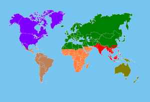
Continents
A continent is one of several large landmassLandmass
A landmass is a contiguous area of land surrounded by ocean. Although it may be most often written as one word to distinguish it from the usage "land mass"—the measure of land area—it is also used as two words.Landmasses include:*supercontinents...
es on Earth
Earth
Earth is the third planet from the Sun, and the densest and fifth-largest of the eight planets in the Solar System. It is also the largest of the Solar System's four terrestrial planets...
. They are generally identified by convention
Convention (norm)
A convention is a set of agreed, stipulated or generally accepted standards, norms, social norms or criteria, often taking the form of a custom....
rather than any specific criteria, but seven areas are commonly regarded as continents. They are:
Africa
Africa is the world's second largest and second most populous continent, after Asia. At about 30.2 million km² including adjacent islands, it covers 6% of the Earth's total surface area and 20.4% of the total land area...
(outline
Outline of Africa
The following outline provides an overview of and topical guide to the continent Africa:Africa – world's second largest and second most populous continent, after Asia.-Geography of Africa:* Atlas of Africa* List of cities in Africa...
) – 2. Antarctica – 3. Australia
Australia
Australia , officially the Commonwealth of Australia, is a country in the Southern Hemisphere comprising the mainland of the Australian continent, the island of Tasmania, and numerous smaller islands in the Indian and Pacific Oceans. It is the world's sixth-largest country by total area...
(outline) –
North America
North America is a continent wholly within the Northern Hemisphere and almost wholly within the Western Hemisphere. It is also considered a northern subcontinent of the Americas...
(outline) – 5. South America
South America
South America is a continent situated in the Western Hemisphere, mostly in the Southern Hemisphere, with a relatively small portion in the Northern Hemisphere. The continent is also considered a subcontinent of the Americas. It is bordered on the west by the Pacific Ocean and on the north and east...
(outline) –
Europe
Europe is, by convention, one of the world's seven continents. Comprising the westernmost peninsula of Eurasia, Europe is generally 'divided' from Asia to its east by the watershed divides of the Ural and Caucasus Mountains, the Ural River, the Caspian and Black Seas, and the waterways connecting...
(outline) – 7. Asia
Asia
Asia is the world's largest and most populous continent, located primarily in the eastern and northern hemispheres. It covers 8.7% of the Earth's total surface area and with approximately 3.879 billion people, it hosts 60% of the world's current human population...
(outline
Outline of Asia
The following outline is provided as an overview of and topical guide to Asia:Asia – world's largest and most populous continent, located primarily in the eastern and northern hemispheres...
) –
Biogeographic regions
Ecozone
- Main article: EcozoneEcozoneAn ecozone is the broadest biogeographic division of the Earth's land surface, based on distributional patterns of terrestrial organisms.Ecozones delineate large areas of the Earth's surface within which organisms have been evolving in relative isolation over long periods of time, separated from...
The World Wildlife Fund (WWF) developed a system of eight biogeographic realms (ecozones):
- NearcticNearcticThe Nearctic is one of the eight terrestrial ecozones dividing the Earth's land surface.The Nearctic ecozone covers most of North America, including Greenland and the highlands of Mexico...
22.9 mil. km² (including most of North AmericaNorth AmericaNorth America is a continent wholly within the Northern Hemisphere and almost wholly within the Western Hemisphere. It is also considered a northern subcontinent of the Americas...
) - PalearcticPalearcticThe Palearctic or Palaearctic is one of the eight ecozones dividing the Earth's surface.Physically, the Palearctic is the largest ecozone...
54.1 mil. km² (including the bulk of EurasiaEurasiaEurasia is a continent or supercontinent comprising the traditional continents of Europe and Asia ; covering about 52,990,000 km2 or about 10.6% of the Earth's surface located primarily in the eastern and northern hemispheres...
and North AfricaNorth AfricaNorth Africa or Northern Africa is the northernmost region of the African continent, linked by the Sahara to Sub-Saharan Africa. Geopolitically, the United Nations definition of Northern Africa includes eight countries or territories; Algeria, Egypt, Libya, Morocco, South Sudan, Sudan, Tunisia, and...
) - AfrotropicAfrotropicThe Afrotropic is one of the Earth's eight ecozones. It includes Africa south of the Sahara Desert, the southern and eastern fringes of the Arabian Peninsula, the island of Madagascar, southern Iran and extreme southwestern Pakistan, and the islands of the western Indian Ocean. It was formerly...
22.1 mil. km² (including Sub-Saharan AfricaSub-Saharan AfricaSub-Saharan Africa as a geographical term refers to the area of the African continent which lies south of the Sahara. A political definition of Sub-Saharan Africa, instead, covers all African countries which are fully or partially located south of the Sahara...
) - IndomalayaIndomalayaThe Indomalaya ecozone is one of the eight ecozones that cover the planet's land surface. It extends across most of South and Southeast Asia and into the southern parts of East Asia....
7.5 mil. km² (including the South Asian subcontinentIndian subcontinentThe Indian subcontinent, also Indian Subcontinent, Indo-Pak Subcontinent or South Asian Subcontinent is a region of the Asian continent on the Indian tectonic plate from the Hindu Kush or Hindu Koh, Himalayas and including the Kuen Lun and Karakoram ranges, forming a land mass which extends...
and Southeast AsiaSoutheast AsiaSoutheast Asia, South-East Asia, South East Asia or Southeastern Asia is a subregion of Asia, consisting of the countries that are geographically south of China, east of India, west of New Guinea and north of Australia. The region lies on the intersection of geological plates, with heavy seismic...
) - AustralasiaAustralasia ecozoneThe Australasian zone is an ecological region that is coincident, but not synonymous , with the geographic region of Australasia...
7.7 mil. km² (including AustraliaAustraliaAustralia , officially the Commonwealth of Australia, is a country in the Southern Hemisphere comprising the mainland of the Australian continent, the island of Tasmania, and numerous smaller islands in the Indian and Pacific Oceans. It is the world's sixth-largest country by total area...
, New GuineaNew GuineaNew Guinea is the world's second largest island, after Greenland, covering a land area of 786,000 km2. Located in the southwest Pacific Ocean, it lies geographically to the east of the Malay Archipelago, with which it is sometimes included as part of a greater Indo-Australian Archipelago...
, and neighbouring islands). The northern boundary of this zone is known as the Wallace lineWallace LineThe Wallace Line separates the ecozones of Asia and Wallacea, a transitional zone between Asia and Australia. West of the line are found organisms related to Asiatic species; to the east, a mixture of species of Asian and Australian origin is present...
. - NeotropicNeotropicIn biogeography, the Neotropic or Neotropical zone is one of the eight terrestrial ecozones. This ecozone includes South and Central America, the Mexican lowlands, the Caribbean islands, and southern Florida, because these regions share a large number of plant and animal groups.It is sometimes used...
19.0 mil. km² (including South AmericaSouth AmericaSouth America is a continent situated in the Western Hemisphere, mostly in the Southern Hemisphere, with a relatively small portion in the Northern Hemisphere. The continent is also considered a subcontinent of the Americas. It is bordered on the west by the Pacific Ocean and on the north and east...
and the CaribbeanCaribbeanThe Caribbean is a crescent-shaped group of islands more than 2,000 miles long separating the Gulf of Mexico and the Caribbean Sea, to the west and south, from the Atlantic Ocean, to the east and north...
) - OceaniaOceania ecozoneOceania is one of the WWF ecozones, and unique in not including any continental land mass. The ecozone includes the Pacific Ocean islands of Micronesia, the Fijian Islands, and most of Polynesia...
1.0 mil. km² (including PolynesiaPolynesiaPolynesia is a subregion of Oceania, made up of over 1,000 islands scattered over the central and southern Pacific Ocean. The indigenous people who inhabit the islands of Polynesia are termed Polynesians and they share many similar traits including language, culture and beliefs...
, FijiFijiFiji , officially the Republic of Fiji , is an island nation in Melanesia in the South Pacific Ocean about northeast of New Zealand's North Island...
and MicronesiaMicronesiaMicronesia is a subregion of Oceania, comprising thousands of small islands in the western Pacific Ocean. It is distinct from Melanesia to the south, and Polynesia to the east. The Philippines lie to the west, and Indonesia to the southwest....
) - Antarctic 0.3 mil. km² (including Antarctica).
Ecoregions
- Main article: EcoregionEcoregionAn ecoregion , sometimes called a bioregion, is an ecologically and geographically defined area that is smaller than an ecozone and larger than an ecosystem. Ecoregions cover relatively large areas of land or water, and contain characteristic, geographically distinct assemblages of natural...
Ecozones are further divided into ecoregions. The World has over 800 terrestrial ecoregions. See Lists of ecoregions by country.
Geography of the political divisions of the World
- Geography of AfricaGeography of AfricaAfrica is a continent comprising 62 political territories, representing the largest of the great southward projections from the main mass of Earth's surface...
(OutlineOutline of AfricaThe following outline provides an overview of and topical guide to the continent Africa:Africa – world's second largest and second most populous continent, after Asia.-Geography of Africa:* Atlas of Africa* List of cities in Africa...
)- West Africa#Geography and climate
- Geography of BeninGeography of BeninBenin, a narrow, key-shaped, north-south strip of land in West Africa, lies between the Equator and the Tropic of Cancer. Benin's latitude ranges from 6°30′ N to 12°30′ N and its longitude from 1° E to 3°40′ E. Benin is bounded by Togo to the west, Burkina Faso and Niger to the...
(OutlineOutline of Beninthumb|The location of [[Benin]]thumb|An enlargeable map of the [[Republic of Benin]]The Republic of Benin is a sovereign country located in West Africa. Benin borders Togo to the west, Nigeria to the east and Burkina Faso and Niger to the north; its short coastline to the south leads to the Bight...
) - Geography of Burkina FasoGeography of Burkina FasoBurkina Faso is a landlocked Sahel country that shares borders with six nations. It lies between the Sahara Desert and the Gulf of Guinea, south of the loop of the Niger River. The land is green in the south, with forests and fruit trees, and desert in the north...
(OutlineOutline of Burkina FasoBurkina Faso, also known by its short-form name Burkina, is a landlocked sovereign country located in West Africa. It is surrounded by six countries: Mali to the north, Niger to the east, Benin to the south east, Togo and Ghana to the south, and Côte d'Ivoire to the south west...
) - Geography of Cape VerdeGeography of Cape VerdeCape Verde is a group of arid Atlantic islands which are home to a number of birds and reptiles and constitute a unique ecoregion in the World Wildlife Fund classification.- Location and description :...
(OutlineOutline of Cape Verdethumb|A relief map of the [[Republic of Cape Verde]]The Republic of Cape Verde is a sovereign country located on an archipelago in the Macaronesia ecoregion of the North Atlantic Ocean, off the western coast of Africa...
) - Geography of Côte d'IvoireGeography of Côte d'IvoireCôte d'Ivoire is a sub-Saharan nation in southern West Africa located at 8 00°N, 5 00°W. The country is shaped like a square and borders the Gulf of Guinea on the north Atlantic Ocean to the south and five other African nations on the other three sides, with a total of 3,110 km of borders:...
(OutlineOutline of Côte d'IvoireThe Republic of Côte d'Ivoire, commonly called Ivory Coast, is a sovereign country located in West Africa. The government officially discourages the use of the name Ivory Coast in English, preferring the French name Côte d'Ivoire to be used in all languages...
) - Geography of Gambia (OutlineOutline of the GambiaThe Republic of the Gambia, commonly known as the Gambia, is a sovereign country located in West Africa. It is the smallest country on the African continental mainland and is bordered to the north, east, and south by Senegal, and has a small coast on the Atlantic Ocean in the west...
) - Geography of GhanaGeography of GhanaGhana is a country in West Africa, along the Gulf of Guinea, just a few degrees north of the equator.-Location and size:Ghana, which lies in the center of the West African coast, shares 2,093 km of land borders with the three French-speaking nations of Burkina Faso to the north, Côte d'Ivoire to...
(OutlineOutline of GhanaThe Republic of Ghana is a sovereign country located in West Africa. Ghana borders Côte d'Ivoire to the west, Burkina Faso to the north, Togo to the east, and the Gulf of Guinea to the south...
) - Geography of GuineaGeography of GuineaGuinea Coast of West Africa and is bordered by Guinea-Bissau, Senegal, Mali, Côte d'Ivoire, Liberia, and Sierra Leone. The country is divided into four geographic regions: A lowland belt running north to south behind the coast , which is part of the Guinean forest-savanna mosaic ecoregion; the...
(OutlineOutline of GuineaThe Republic of Guinea is a sovereign country located in West Africa, that was formerly known as French Guinea. Guinea's territory has a curved shape, with its base at the Atlantic Ocean, inland to the east, and turning south...
) - Geography of Guinea-BissauGeography of Guinea-BissauThis article describes the geography of Guinea-Bissau.- Climate :The climate in Guinea-Bissau is tropical. This means it is generally hot and humid...
(OutlineOutline of Guinea-BissauThe Republic of Guinea-Bissau is a sovereign country located in West Africa. Guinea-Bissau is the 8th least extensive country in continental Africa. It is bordered by Senegal to the north, and Guinea to the south and east, with the Atlantic Ocean to its west...
) - Geography of LiberiaGeography of LiberiaLiberia is a large Sub-Saharan nation in West Africa located at 6 °N, 9 °W. The country is shaped like a rectangle, with a shape similar to El Salvador. It borders the north Atlantic Ocean to the southwest and three other African nations on the other three sides...
(OutlineOutline of LiberiaThe Republic of Liberia is a sovereign country located in West Africa, bordered by Sierra Leone, Guinea, Côte d'Ivoire, and the Atlantic Ocean. Liberia has a hot equatorial climate with most rainfall arriving in summer with harsh harmattan winds in the dry season...
) - Geography of MaliGeography of MaliMali is a landlocked nation in West Africa, located southwest of Algeria, extending south-west from the southern Sahara through the Sahel to the Sudanian savanna zone....
(OutlineOutline of MaliThe Republic of Mali is a landlocked sovereign country located in West Africa. Mali is the seventh most extensive country in Africa, bordering Algeria on the north, Niger on the east, Burkina Faso and the Côte d'Ivoire on the south, Guinea on the south-west, and Senegal and Mauritania on the...
) - Geography of MauritaniaGeography of MauritaniaMauritania, a country in the western region of the continent of Africa, is generally flat, its 1,030,700 square kilometres forming vast, arid plains broken by occasional ridges and clifflike outcroppings. It borders the North Atlantic Ocean, between Senegal and Western Sahara, Mali and Algeria. It...
(OutlineOutline of MauritaniaThe Islamic Republic of Mauritania is a sovereign country located in West Africa. Mauritania is bordered by the Atlantic Ocean on the west, by Senegal on the southwest, by Mali on the east and southeast, by Algeria on the northeast, and by the Morocco-controlled Western Sahara on the northwest. It...
) - Geography of NigerGeography of NigerNiger is a landlocked nation in West Africa located along the border between the Sahara and Sub-Saharan regions. Its geographic coordinates are a longitude of 16°N and a latitude off 8°E. Its area is 1.267 million square kilometers, of which 1 266 700 km² is land and 300 km²...
(OutlineOutline of NigerThe Republic of Niger is a landlocked sovereign country located in West Africa. Niger was named for the Niger River. It borders Nigeria and Benin to the south, Burkina Faso and Mali to the west, Algeria and Libya to the north and Chad to the east...
) - Geography of NigeriaGeography of NigeriaNigeria is a country in West Africa. Nigeria shares land borders with the Republic of Benin in the west, Chad and Cameroon in the east, and Niger in the north. Its coast lies on the Gulf of Guinea in the south and it borders Lake Chad to the northeast...
(OutlineOutline of NigeriaThe Federal Republic of Nigeria is a sovereign country located in West Africa. Nigeria is a federal constitutional republic comprising thirty-six states and one Federal Capital Territory. Nigeria borders the Republic of Benin in the west, Chad and Cameroon in the east, and Niger in the north. Its...
) - Geography of SenegalGeography of SenegalSenegal is a coastal West African nation located 14 degrees north of the Equator and 14 degrees west of the Prime Meridian. The country's total area is 196 190 km² of which 192 000 km² is land and 4 190 km² is water, making the nation slightly smaller than Britain or...
(OutlineOutline of SenegalThe Republic of Senegal is a sovereign country located south of the Sénégal River in West Africa. Senegal is bound by the Atlantic Ocean to the west, Mauritania to the north, Mali to the east, and Guinea and Guinea-Bissau to the south...
) - Geography of Sierra LeoneGeography of Sierra LeoneSierra Leone is located on the west coast of Africa, between the 7th and 10th parallels north of the equator. Sierra Leone is bordered by Guinea to the north and northeast, Liberia to the south and southeast, and the Atlantic Ocean to the west. The country has a total area of , divided into a land...
(OutlineOutline of Sierra LeoneThe Republic of Sierra Leone is a sovereign country located in West Africa. Sierra Leone is bordered by Guinea in the northeast, Liberia in the southeast, and the Atlantic Ocean in the southwest. Sierra Leone covers a total area of 71,740 km² and has a population of 5,900,000...
) - Geography of TogoGeography of TogoTogo is a small Sub-Saharan nation comprising a long strip of land in West Africa. Togo's geographic coordinates are a latitude of 8° north and a longitude of 1°10′ east. It is bordered by three countries: Benin to the east, with of border; Burkina Faso to the north, with of border; and...
(OutlineOutline of TogoThe Togolese Republic, commonly known as Togo, is a narrow, sovereign country located in West Africa bordering Ghana to the west, Benin to the east and Burkina Faso to the north. The country extends south to the Gulf of Guinea, on which the capital Lomé is located...
)
- Geography of Benin
- North Africa#Geography
- Geography of AlgeriaGeography of AlgeriaAlgeria comprises 2,381,741 square kilometers of land, more than four-fifths of which is desert, in northern Africa, between Morocco and Tunisia. It is the largest country in Africa. Its Arabic name, Al Jazair , derives from the name of the capital Algiers , after the small islands formerly found...
(OutlineOutline of Algeriathumb|The location of [[Algeria]]thumb|An enlargeable relief map of the [[People's Democratic Republic of Algeria]]The following outline is provided as an overview of and topical guide to Algeria:...
) - Geography of EgyptGeography of EgyptThe Geography of Egypt relates to two regions: Southwest Asia and North Africa.Egypt has coastlines on both the Mediterranean Sea and the Red Sea. The country borders Libya to the west, the Gaza Strip and Israel to the east, and Sudan to the south...
(Outline) - Geography of LibyaGeography of LibyaLibya is fourth in size among the countries of Africa and seventeenth among the countries of the world. Its coastline lies between Egypt and Tunisia...
(OutlineOutline of LibyaThe following outline is provided as an overview of and topical guide to Libya:- General reference :* Pronunciation:* Common English country name: Libya* Official English country name: Libya, or Libyan Republic* Common endonym: * Official endonym:...
) - Geography of MauritaniaGeography of MauritaniaMauritania, a country in the western region of the continent of Africa, is generally flat, its 1,030,700 square kilometres forming vast, arid plains broken by occasional ridges and clifflike outcroppings. It borders the North Atlantic Ocean, between Senegal and Western Sahara, Mali and Algeria. It...
(OutlineOutline of MauritaniaThe Islamic Republic of Mauritania is a sovereign country located in West Africa. Mauritania is bordered by the Atlantic Ocean on the west, by Senegal on the southwest, by Mali on the east and southeast, by Algeria on the northeast, and by the Morocco-controlled Western Sahara on the northwest. It...
) - Geography of MoroccoGeography of MoroccoThe geography of Morocco spans from the Atlantic Ocean, to mountainous areas, to the Sahara . Morocco is a Northern African country, bordering the North Atlantic Ocean and the Mediterranean Sea....
(OutlineOutline of MoroccoThe Kingdom of Morocco is a sovereign country located in western North Africa. Morocco has a coast on the Atlantic Ocean that reaches past the Strait of Gibraltar into the Mediterranean Sea...
) - Geography of SudanGeography of SudanSudan is located in northeastern Africa. It is bordered by Egypt to the north, the Red Sea to the northeast, Eritrea and Ethiopia to the east, South Sudan to the south, the Central African Republic to the southwest, Chad to the west and Libya to the northwest...
(OutlineOutline of SudanThe Republic of Sudan is a sovereign country located in eastern North Africa. Sudan is the second most extensive country in Africa and the sixteenth most extensive country in the world...
) - Geography of TunisiaGeography of TunisiaTunisia is a country located in Northern Africa, bordering the Mediterranean Sea, between Algeria and Libya. Its geographic coordinates are . Tunisia occupies an area of 163,610 square kilometres, of which 8,250 are water...
(OutlineOutline of TunisiaTunisia , officially the Tunisian Republic , is the northernmost country in Africa situated on the southern coast of the Mediterranean Sea. Tunisia is the smallest of the nations situated along the Atlas mountain range. The south of the country is composed of the Sahara desert, with much of the...
) - Geography of Western SaharaGeography of Western SaharaWestern Sahara is a territory in Northern Africa, bordered by the North Atlantic Ocean, Morocco proper, Algeria , and Mauritania. Geographic coordinates: -Size:Total: 266,060 km²*Land boundaries: 2,046 km...
(OutlineOutline of Western SaharaWestern Sahara is a disputed territory located in western North Africa, bordered by Morocco to the north, Algeria in the northeast, Mauritania to the east and south, and the North Atlantic Ocean on the west. It is one of the most sparsely populated territories in the world, mainly consisting of...
)
- Geography of Algeria
- Central AfricaCentral AfricaCentral Africa is a core region of the African continent which includes Burundi, the Central African Republic, Chad, the Democratic Republic of the Congo, and Rwanda....
- Geography of AngolaGeography of AngolaAngola is located on the western Atlantic Coast of southern Africa between Namibia and the Republic of the Congo. It also is bordered by the Democratic Republic of the Congo and Zambia to the east...
(OutlineOutline of AngolaThe Republic of Angola is a sovereign country located in Middle Africa. Angola borders Namibia to the south, the Democratic Republic of the Congo to the north, and Zambia to the east, and with a west coast along the Atlantic Ocean. The exclave province Cabinda has a border with the Republic of...
) - Geography of BurundiGeography of BurundiBurundi is located in central Africa, to the east of the Democratic Republic of the Congo, at the co-ordinates .-Physical geography:Burundi occupies an area equal to 27,830 square kilometres in size, of which 25,650 km² is land...
(OutlineOutline of Burundithumb|The location of [[Burundi]]thumb|An enlargeable map of the [[Republic of Burundi]]The Republic of Burundi is a small sovereign country located in the Great Lakes region of Africa. Burundi is bordered by Rwanda on the north, Tanzania on the south and east, and the Democratic Republic of the...
) - Geography of CameroonGeography of CameroonAt , Cameroon is the world's 54th-largest country. It is comparable in size to Papua New Guinea, and somewhat larger than the U.S. state of California...
(OutlineOutline of Cameroonthumb|An enlargeable map of the [[Republic of Cameroon]]The Republic of Cameroon is a unitary republic located in Middle Africa. Cameroon borders Nigeria to the west; Chad to the northeast; the Central African Republic to the east; and Equatorial Guinea, Gabon, and the Republic of the Congo to the...
) - Geography of Central African Republic (OutlineOutline of the Central African Republicthumb|The location of the [[Central African Republic]]thumb|An enlargeable map of the [[Central African Republic]]The Central African Republic is a landlocked sovereign country located in Central Africa...
) - Geography of ChadGeography of ChadChad is a land-locked country in north central Africa measuring , roughly three times the size of California. Most of its ethnically and linguistically diverse population lives in the south, with densities ranging from 54 persons per square kilometers in the Logone River basin to 0.1 persons in the...
(OutlineOutline of Chadthumb|The location of [[Chad]]thumb|An enlargeable map of the [[Republic of Chad]]The Republic of Chad is a landlocked country in Central Africa. It is bordered by Libya to the north, Sudan to the east, the Central African Republic to the south, Cameroon and Nigeria to the southwest, and Niger to...
) - Geography of Democratic Republic of the Congo (OutlineOutline of the Democratic Republic of the CongoThe Democratic Republic of the Congo, often referred to as DR Congo, DRC or RDC, and formerly known or referred to as the Congo Free State, the Belgian Congo, the Congo-Léopoldville, Congo-Kinshasa, and Zaire , is the second most extensive country on the African continent...
) - Geography of Equatorial GuineaGeography of Equatorial GuineaThe Republic of Equatorial Guinea is located in west central Africa. Bioko Island lies about from Cameroon. Annobón Island lies about southwest of Bioko Island...
(OutlineOutline of Equatorial GuineaThe Republic of Equatorial Guinea is a sovereign country located on the Gulf of Guinea in Middle Africa. It is one of the smallest countries in continental Africa, and comprises two regions: Río Muni, continental region including several offshore islands; andInsular Region containing Annobón...
) - Geography of GabonGeography of GabonGabon is a country in West Africa, lying along the Atlantic Ocean, just south of the Bight of Biafra.-Borders:Gabon has a total of 2,551 km of international boundaries. It borders Equatorial Guinea and Cameroon to the north and the Republic of the Congo to the west and south...
(OutlineOutline of GabonGabon is a country in west central Africa sharing borders with the Gulf of Guinea to the west, Equatorial Guinea to the northwest, and Cameroon to the north, with the Republic of the Congo curving around the east and south...
) - Geography of Republic of the Congo (OutlineOutline of the Republic of the CongoThe Republic of the Congo, also known as Congo-Brazzaville or the Congo, is a sovereign country located in Central Africa. It is bordered by Gabon, Cameroon, the Central African Republic, the Democratic Republic of the Congo, the Angolan exclave province of Cabinda, and the Gulf of Guinea.The...
) - Geography of RwandaGeography of RwandaRwanda is a landlocked country located in Central Africa, to the east of the Democratic Republic of the Congo. Its countryside consists of grasslands and rolling hills, and it has a temperate climate.-Political geography:...
(OutlineOutline of RwandaThe Republic of Rwanda is a small landlocked sovereign country located in the Great Lakes region of east-central Africa, bordered by Uganda, Burundi, the Democratic Republic of the Congo and Tanzania. Home to approximately 10.1 million people, Rwanda supports the densest population in continental...
) - Geography of São Tomé and PríncipeGeography of São Tomé and PríncipeSão Tomé and Príncipe is a small nation composed of an archipelago located in the Gulf of Guinea of equatorial Atlantic Ocean. The nation's main islands are São Tomé and Príncipe, for which the country is named. These are located about , respectively, off the northwest coast of Gabon in West Africa...
(OutlineOutline of São Tomé and PríncipeThe Democratic Republic of São Tomé and Príncipe is a sovereign island nation located in the Gulf of Guinea, off the western equatorial coast of Africa. The republic comprises two main islands: São Tomé Island and Príncipe Island, located about apart and about and , respectively, off the...
)
- Geography of Angola
- East Africa#Geography and climate
- Geography of BurundiGeography of BurundiBurundi is located in central Africa, to the east of the Democratic Republic of the Congo, at the co-ordinates .-Physical geography:Burundi occupies an area equal to 27,830 square kilometres in size, of which 25,650 km² is land...
(OutlineOutline of Burundithumb|The location of [[Burundi]]thumb|An enlargeable map of the [[Republic of Burundi]]The Republic of Burundi is a small sovereign country located in the Great Lakes region of Africa. Burundi is bordered by Rwanda on the north, Tanzania on the south and east, and the Democratic Republic of the...
) - Geography of ComorosGeography of ComorosThe Comoros archipelago consists of four main islands aligned along a northwest-southeast axis at the north end of the Mozambique Channel, between Mozambique and the island of Madagascar. Still widely known by their French names, the islands officially have been called by their Swahili names by the...
(OutlineOutline of Comorosthumb|The location of the [[Comoros]]thumb|An enlargeable map of the [[Union of the Comoros]]The Union of the Comoros is a sovereign island nation located in the Indian Ocean off the eastern coast of Africa on the northern end of the Mozambique Channel between northern Madagascar and northeastern...
) - Geography of DjiboutiGeography of Djibouti-Location:Djibouti shares of border with Eritrea, with Ethiopia and with Somalia . It also has of coastline.It has a strategic location near the world's busiest shipping lanes and close to Arabian oilfields. Djibouti is also terminus of rail traffic into Ethiopia.-Terrain:Mountains in the...
(OutlineOutline of DjiboutiThe Republic of Djibouti is a sovereign country located on the Horn of Africa. Djibouti is bordered by Eritrea in the north, Ethiopia in the west and south, and Somalia in the southeast. The remainder of the border is formed by the Red Sea and the Gulf of Aden. On the other side of the Red Sea, on...
)- Geography of EritreaGeography of EritreaEritrea is located in the Horn of Africa and is bordered on the northeast and east by the Red Sea, on the west and northwest by Sudan, on the south by Ethiopia, and on the southeast by Djibouti. The country has a high central plateau that varies from above sea level. A coastal plain, western...
(OutlineOutline of EritreaThe State of Eritrea is a sovereign country located in Northeast Africa. Eritrea is bordered by Sudan in the west, Ethiopia in the south, and Djibouti in the southeast. The east and northeast of the country have an extensive coastline on the Red Sea, directly across from Saudi Arabia and Yemen...
)
- Geography of Eritrea
- Geography of EthiopiaGeography of EthiopiaEthiopia is located in the Horn of Africa and is bordered on the north and northeast by Eritrea, on the east by Djibouti and Somalia, on the south by Kenya, on the northwest by Sudan and on the southwest by South Sudan. The country has a high central plateau that varies from above sea level, with...
(OutlineOutline of EthiopiaThe Federal Democratic Republic of Ethiopia is a landlocked sovereign country located in the Horn of Africa. Ethiopia is bordered by Eritrea to the north, Sudan to the west, South Sudan to the south-west, Kenya to the south, Somalia to the east and Djibouti to the north-east.Ethiopia is one of the...
) - Geography of KenyaGeography of KenyaThe geography of Kenya is diverse. Kenya has a coastline on the Indian Ocean, which contains swamps of East African mangroves. Inland are broad plains and numerous hills. Central and Western Kenya is characterized by the Great Rift Valley home to three of Africa's highest mountains, Mount Kenya,...
(OutlineOutline of KenyaThe Republic of Kenya is a country in East Africa.Lying along the Indian Ocean, at the equator, Kenya is bordered by Ethiopia , Somalia , Tanzania , Uganda plus Lake Victoria , and South Sudan . The capital city is Nairobi, 2nd largest in Africa . Kenya spans an area about 85% the size of France or...
) - Geography of MadagascarGeography of MadagascarMadagascar is an island in the Indian Ocean off the eastern coast of southern Africa, east of Mozambique. It is the fourth largest island in the world. The highest point is Maromokotro, in the Tsaratanana Massif region in the north of the island, at . The capital Antananarivo is in the Hauts...
(OutlineOutline of MadagascarThe Republic of Madagascar, formerly the Malagasy Republic, is a sovereign island nation located in the Indian Ocean off the southeastern coast of Africa. The Island of Madagascar is the fourth-largest island in the world, and is home to 5% of the world's plant and animal species, of which more...
) - Geography of MalawiGeography of MalawiMalawi is situated in southeastern Africa. It is wholly within the tropics; from about 9°30S at its northernmost point to about 17°S at the southernmost tip....
(OutlineOutline of MalawiThe Republic of Malawi, formerly Nyasaland, is a sovereign country located in southeastern Africa. Malawi is bordered by Zambia to the northwest, Tanzania to the north and Mozambique, which surrounds it on the east, south and west and is separated from Malawi by Lake Malawi...
) - Geography of MauritiusGeography of Mauritius- Climate :The local climate is tropical, modified by southeast trade winds; there is a warm, dry winter from May to November and a hot, wet, and humid summer from November to May. Anti-cyclones affect the country during May to September. Cyclones affect the country during November-April...
(OutlineOutline of MauritiusThe Republic of Mauritius is a sovereign island nation located in the southwest Indian Ocean about east of Madagascar. In addition to the Island of Mauritius, the republic includes the islands of St. Brandon, Rodrigues and the Agalega Islands...
) - Geography of MozambiqueGeography of MozambiqueLocation:Southern Africa, bordering the Mozambique Channel, between South Africa and TanzaniaGeographic coordinates:Map references:AfricaArea:total:801 590 km²land:784 090 km²water:17 500 km²...
(OutlineOutline of MozambiqueThe Republic of Mozambique is a sovereign country located in southeastern Africa bordered by the Indian Ocean to the east, Tanzania to the north, Malawi and Zambia to the northwest, Zimbabwe to the west and Swaziland and South Africa to the southwest. Mozambique was explored by Vasco da Gama in...
) - Geography of RwandaGeography of RwandaRwanda is a landlocked country located in Central Africa, to the east of the Democratic Republic of the Congo. Its countryside consists of grasslands and rolling hills, and it has a temperate climate.-Political geography:...
(OutlineOutline of RwandaThe Republic of Rwanda is a small landlocked sovereign country located in the Great Lakes region of east-central Africa, bordered by Uganda, Burundi, the Democratic Republic of the Congo and Tanzania. Home to approximately 10.1 million people, Rwanda supports the densest population in continental...
) - Geography of SeychellesGeography of SeychellesThe Seychelles is a small island nation located in the Indian Ocean northeast of Madagascar and about east of Kenya. Seychelles lies between approximately 4ºS and 10ºS and 46ºE and 54ºE. The nation is an archipelago of 155 tropical islands, some granite and some coral. the majority of which are...
(OutlineOutline of SeychellesThe Republic of Seychelles is a sovereign island nation located in the Indian Ocean and comprising 115 islands of the Seychelles Archipelago, some east of mainland Africa and northeast of the Island of Madagascar...
) - Geography of SomaliaGeography of SomaliaAfrica's easternmost country. Somalia has a land area of 637,540 square kilometers. Somalia occupies the tip of a region commonly referred to as the Horn of Africa that also includes Ethiopia, Eritrea and Djibouti. Somalia's terrain consists mainly of plateaus, plains, and highlands...
(OutlineOutline of SomaliaSomalia , officially the Republic of Somalia and formerly known as the Somali Democratic Republic under communist rule, is a country located in the Horn of Africa. It is bordered by Djibouti to the northwest, Kenya to the southwest, the Gulf of Aden with Yemen to the north, the Indian Ocean to the...
) - Geography of TanzaniaGeography of TanzaniaTanzania's geography is one of the most varied and unique in the world; it contains Africa's highest point, Mount Kilimanjaro , as well as lakes, mountains and many natural parks....
(OutlineOutline of TanzaniaThe United Republic of Tanzania is a sovereign country located in East Africa. Tanzania borders Kenya and Uganda on the north, Rwanda, Burundi and the Democratic Republic of the Congo on the west, and Zambia, Malawi and Mozambique on the south...
) - Geography of UgandaGeography of UgandaUganda is located in Eastern Africa, west of Kenya, south of South Sudan and east of the Democratic Republic of the Congo. It is in the heart of the Great Lakes region, and is surrounded by three of them, Lake Edward, Lake Albert, and Lake Victoria...
(OutlineOutline of UgandaThe Republic of Uganda is a landlocked sovereign country located in East Africa, bordered on the east by Kenya, the north by South Sudan, on the west by the Democratic Republic of the Congo, on the southwest by Rwanda, and on the south by Tanzania. The southern part of the country includes a...
) - Geography of ZambiaGeography of ZambiaZambia is a landlocked country located in Southern Africa, to the east of Angola. It has a total area of 752 618 square kilometres , of which 9 220 km² are water.-Political geography:...
(OutlineOutline of ZambiaThe Republic of Zambia is a landlocked sovereign country located in Southern Africa. Zambia borders the Democratic Republic of the Congo to the north, Tanzania to the north-east, Malawi to the east, Mozambique, Zimbabwe, Botswana, and Namibia to the south, and Angola to the west. The capital of...
) - Geography of ZimbabweGeography of ZimbabweZimbabwe is a landlocked country in southern Africa lying while within the tropics. It straddles an extensive high inland plateau that drops northwards to the Zambezi valley where the border with Zambia is and similarly drops southwards to the Limpopo valley and the border with South Africa.The...
(OutlineOutline of ZimbabweThe Republic of Zimbabwe, formerly known as Southern Rhodesia, the Republic of Rhodesia, and Zimbabwe Rhodesia, is a landlocked sovereign country located in Southern Africa, between the Zambezi River and Limpopo River....
)
- Geography of Burundi
- Southern Africa#Geography
- Geography of BotswanaGeography of BotswanaBotswana is a landlocked country located in Southern Africa, north of South Africa. Botswana occupies an area of 600,370 square kilometres, of which 585,000 km² are land...
(OutlineOutline of Botswanathumb|The location of [[Botswana]]thumb|An enlargeable relief map of the [[Republic of Botswana]]The Republic of Botswana is a landlocked sovereign country located in Southern Africa. Citizens of Botswana are Batswana , regardless of ethnicity...
) - Geography of LesothoGeography of LesothoLesotho is a mountainous, landlocked country located in Southern Africa. It is an enclave, completely surrounded by South Africa. The total length of the country's borders is...
(OutlineOutline of LesothoThe Kingdom of Lesotho is a sovereign country located in Southern Africa. Lesotho is an enclave completely surrounded by the Republic of South Africa. Formerly Basutoland, it is a member of the Commonwealth of Nations...
) - Geography of NamibiaGeography of NamibiaAt , Namibia is the world's thirty-fourth largest country . After Mongolia, Namibia is the least densely populated country in the world .-Geographical areas:...
(OutlineOutline of NamibiaThe Republic of Namibia is a sovereign country located along the Atlantic Coast of Southern Africa. Namibia shares borders with Angola and Zambia to the north, Botswana to the east, and South Africa to the south. It gained independence from South Africa in 1990 and its capital city is Windhoek...
) - Geography of South AfricaGeography of South AfricaSouth Africa occupies the southern tip of Africa, its coastline stretching more than from the desert border with Namibia on the Atlantic coast southwards around the tip of Africa and then north to the border with Mozambique on the Indian Ocean...
(OutlineOutline of South AfricaThe Republic of South Africa is a sovereign country located at the southern tip of Africa. South Africa's coast stretches 2,798 kilometres and borders both the Atlantic and Indian oceans...
) - Geography of SwazilandGeography of SwazilandSwaziland is a country in Southern Africa, lying between Mozambique and South Africa. The country is located at the geographic coordinates . Swaziland has an area of 17,363 square kilometres, of which 160 are water...
(OutlineOutline of SwazilandThe Kingdom of Swaziland is a small, landlocked, sovereign country located in Southern Africa, bordered by South Africa on three sides except to the east, where it borders Mozambique...
)
- Geography of Botswana
- Dependencies in Africa
- Geography of British Indian Ocean TerritoryGeography of British Indian Ocean TerritoryThe British Indian Ocean Territory is an archipelago of 2,300 islands in the Indian Ocean, located to the south of India, roughly halfway between Africa and Indonesia. The islands have a total area of , including the entire Chagos Archipelago. The coastline of the British Indian Ocean Territory...
(Outline) (UK) - Geography of MayotteGeography of MayotteMayotte is an island of volcanic origin in the northernmost Mozambique Channel, about one-half of the way from northern Madagascar to northern Mozambique. Mayotte is part of the Comoro Islands, and like them is the result of a former hot spot, the oldest of the Comoros archipelago, formed about...
(OutlineOutline of MayotteThe Mayotte is an overseas department of France located in the Comoros Archipelago in the Indian Ocean. The department comprises the main island of Grande-Terre , a smaller island, Petite-Terre , and several islets at the northern end of the Mozambique Channel, between northern Madagascar and...
) (France) - Geography of RéunionGeography of RéunionRéunion is an island in Southern Africa, in the Indian Ocean, east of Madagascar. It is an overseas region of France. The total area of the island is 2,512 km², of which 10 km² is water. The island has a coastline of 207 km...
(Outline) (France) - Geography of Saint HelenaGeography of Saint HelenaSaint Helena is an island in the South Atlantic Ocean, about mid-way between South America and Africa, at the geographic coordinates . St Helena has a land area of 122 square kilometres and is part of a wider territory called Saint Helena, Ascension and Tristan da Cunha which includes Ascension...
(Outline) (UK) - Canary Islands#Geography (Outline) (Spain)
- Geography of Ceuta (Outline) (Spain)
- Geography of Madeira (Outline) (Portugal)
- Geography of Melilla (Outline) (Spain)
- Geography of Socotra (Outline) (Yemen)
- Geography of Puntland (OutlineOutline of Puntlandthumb|The location of [[Puntland]]thumb|Map of the regions claimed by [[Puntland]]Puntland is a region in northeastern Somalia, centered on Garowe , whose leaders declared it an autonomous state in 1998. A third of the Somali people live in the province. Unlike neighbouring Somaliland, Puntland...
) - Geography of Somaliland (OutlineOutline of SomalilandSomaliland is an unrecognised self-declared sovereign state that is internationally recognised as an autonomous region of Somalia. The government of Somaliland regards the territory as the successor state to the British Somaliland protectorate, which was independent for a few days in 1960 as the...
) - Sahrawi Arab Democratic RepublicSahrawi Arab Democratic RepublicThe Sahrawi Arab Democratic Republic is a partially recognised state that claims sovereignty over the entire territory of Western Sahara, a former Spanish colony. SADR was proclaimed by the Polisario Front on February 27, 1976, in Bir Lehlu, Western Sahara. The SADR government controls about...
(Outline)
- Geography of British Indian Ocean Territory
- West Africa#Geography and climate
- Geography of AntarcticaGeography of AntarcticaThe geography of Antarctica is dominated by its south polar location and, thus, by ice. The Antarctic continent, located in the Earth's southern hemisphere, is centered asymmetrically around the South Pole and largely south of the Antarctic Circle...
(Outline) - Geography of AsiaGeography of AsiaGeography of Asia reviews geographical concepts of classifying Asia, the central and eastern part of Eurasia, comprising approximately fifty countries.-Boundary:...
(OutlineOutline of AsiaThe following outline is provided as an overview of and topical guide to Asia:Asia – world's largest and most populous continent, located primarily in the eastern and northern hemispheres...
)- Central Asia#Geography
- Geography of KazakhstanGeography of KazakhstanKazakhstan is located in Central Asia and Eastern Europe. With an area of about 2,717,300 square kilometers, Kazakhstan is more than twice the combined size of the other four Central Asian states, or about twice the size of Alaska...
(OutlineOutline of KazakhstanThe Republic of Kazakhstan is a landlocked sovereign country located across both Central Asia and Eastern Europe. Ranked as the ninth largest country in the world as well as the world's largest landlocked country, it has a territory of 2,727,300 km² . It is bordered by Russia, Kyrgyzstan,...
) - Geography of KyrgyzstanGeography of KyrgyzstanKyrgyzstan is a landlocked nation in Central Asia, west of the People's Republic of China. Less than a seventh the size of Mongolia, at 199,951 square kilometers, Kyrgyzstan is one of the smaller Central Asian states...
(OutlineOutline of KyrgyzstanThe Kyrgyz Republic, commonly known as Kyrgyzstan, is a sovereign country located in Central Asia. Landlocked and mountainous, Kyrgyzstan is bordered by Kazakhstan to the north, Uzbekistan to the west, Tajikistan to the southwest, and China to the east.The following outline is provided as an...
) - Geography of TajikistanGeography of TajikistanTajikistan is nestled between Kyrgyzstan and Uzbekistan to the north and west, China to the east, and Afghanistan to the south. Mountains cover 93 percent of Tajikistan's surface area. The two principal ranges, the Pamir Mountains and the Alay Mountains, give rise to many glacier-fed streams and...
(OutlineOutline of TajikistanThe Republic of Tajikistan is a mountainous, landlocked, sovereign country located in Central Asia. Tajikistan borders Afghanistan to the south, Uzbekistan to the west, Kyrgyzstan to the north, and China to the east...
) - Geography of TurkmenistanGeography of TurkmenistanTurkmenistan is a landlocked country in Central Asia, bordering the Caspian Sea to the west, Iran and Afghanistan to the south, Uzbekistan to the north-east, and Kazakhstan to the north-west...
(OutlineOutline of TurkmenistanTurkmenistan is a sovereign Turkic country located in Central Asia. The name Turkmenistan is derived from Persian, meaning "land of the Turkmen". The name of its capital, Ashgabat, derived from Persian as well, loosely translating as "the city of love". Until 1991, it was a constituent republic of...
) - Geography of UzbekistanGeography of UzbekistanUzbekistan is a country of Central Asia, located north of Turkmenistan and Afghanistan. With an area of 447,000 square kilometers , Uzbekistan stretches 1,425 kilometers from west to east and 930 kilometers from north to south...
(OutlineOutline of UzbekistanThe Republic of Uzbekistan is a doubly landlocked sovereign country located in Central Asia. Uzbekistan borders Kazakhstan to the west and to the north, Kyrgyzstan and Tajikistan to the east, and Afghanistan and Turkmenistan to the south....
)
- Geography of Kazakhstan
- East AsiaEast AsiaEast Asia or Eastern Asia is a subregion of Asia that can be defined in either geographical or cultural terms...
- Geography of ChinaGeography of ChinaChina stretches some across the East Asian landmass bordering the East China Sea, Korea Bay, Yellow Sea, and South China Sea, between North Korea and Vietnam in a changing configuration of broad plains, expansive deserts, and lofty mountain ranges, including vast areas of inhospitable terrain...
(OutlineOutline of Chinaright|188pxthumb|An enlargeable map of the [[People's Republic of China]]The People's Republic of China is the most extensive country in East Asia and the third or fourth most extensive country in the world...
)- Geography of TibetGeography of TibetThe geography of Tibet consists of the high mountains, lakes and rivers lying between Central, East and South Asia. Traditionally, Western sources have regarded Tibet as being in Central Asia, though today's maps show a trend toward considering all of modern China, including Tibet, to be part of...
(OutlineOutline of TibetTibet is a plateau region in Asia and the home to the indigenous Tibetan people. With an average elevation of 4,900 metres , it is the highest region on Earth and is commonly referred to as the "Roof of the World."...
) - Geography of Hong KongGeography of Hong KongThe geography of Hong Kong primarily consists of three main territories: Hong Kong Island, Kowloon Peninsula, and the New Territories.The name "Hong Kong", literally meaning "fragrant harbour", is derived from the area around present-day Aberdeen on Hong Kong Island, where fragrant wood products...
(OutlineOutline of Hong KongThe Hong Kong Special Administrative Region of the People's Republic of China is one of two special administrative regions of China, the other being Macau....
) - Geography of MacauGeography of MacauMacau is a city on the southern coast of China. It is located at the south of Guangdong Province, on the tip of the peninsula formed by the Zhujiang estuary on the east and the Xijiang on the west. Macau is situated 60 km west of Hong Kong and 145 km southwest of Guangzhou, the capital...
(Outline)
- Geography of Tibet
- Geography of JapanGeography of JapanJapan is an island nation in East Asia comprising a stratovolcanic archipelago extending along the Pacific coast of Asia. Measured from the geographic coordinate system, Japan stretches from 24° to 46° north latitude and from 123° to 146° east longitude...
(Outline) - Geography of North KoreaGeography of North KoreaNorth Korea is located in east Asia on the northern half of the Korean Peninsula. North Korea shares a border with three states, including China along the Amnok River, Russia along the Duman River, and South Korea along the Korean Demilitarized Zone...
(OutlineOutline of North KoreaThe Democratic People's Republic of Korea, commonly known as North Korea or the DPRK, is a sovereign country located on the northern half of the Korean Peninsula in East Asia. To the south, separated by the Korean Demilitarized Zone, lies South Korea, with which it formed one nation until division...
) - Geography of South KoreaGeography of South KoreaSouth Korea is located in East Asia, on the southern half of the Korean Peninsula jutting out from the far east of the Asian land mass. The only country with a land border to South Korea is North Korea, lying to the north with of border running along the DMZ. South Korea is mostly surrounded by...
(OutlineOutline of South KoreaThe Republic of Korea, commonly known as South Korea or the ROK, is a densely-populated sovereign presidential republic located on the southern half of the Korean Peninsula in East Asia. Also known as the "Land of the Morning Calm" and The Hermit Kingdom, it is neighbored by China to the west,...
) - Geography of MongoliaGeography of MongoliaMongolia is a landlocked country in Northern Asia, strategically located between China and Russia. The terrain is one of mountains and rolling plateaus, with a high degree of relief. Overall, the land slopes from the high Altay Mountains of the west and the north to plains and depressions in the...
(OutlineOutline of MongoliaMongolia is a landlocked sovereign country located in East-Central Asia. It borders Russia to the north and China to the south. Ulan Bator, the capital and largest city, is home to about 38% of the population...
) - Geography of TaiwanGeography of TaiwanTaiwan is a medium-sized archipelago in East Asia, located at 23°30" N, 121°00" E and running through the middle of the Tropic of Cancer . It makes up the majority of the territories effectively under the administration of the Republic of China .- Formation :The island of Taiwan was formed...
(Outline)
- Geography of China
- North Asia#Geography
- Geography of RussiaGeography of RussiaThe geography of Russia entails the physical and human geography of Russia, a country extending over much of northern Eurasia. Comprising much of eastern Europe and northern Asia, it is the world's largest country in total area. Due to its size, Russia displays both monotony and diversity. As with...
(Outline)
- Geography of Russia
- Southeast Asia#Geography
- Geography of BruneiGeography of BruneiBrunei is in Southeastern Asia, bordering the South China Sea and Malaysia. Its geographical coordinates are .Brunei shares a border with Malaysia and has a coastline.- Climate :See also: Climate...
(OutlineOutline of Bruneithumb|The location of [[Brunei]]thumb|An enlargeable map of the [[State of Brunei, Abode of Peace]]The State of Brunei, Abode of Peace, is a sovereign country located on the north coast of the Island of Borneo in Southeast Asia...
) - Burma (Myanmar) - OutlineOutline of Burmathumb|The location of [[Burma]] .thumb|An enlargeable map of [[Burma]] .Burma, officially known as the Republic of the Union of Myanmar, is the most extensive country in mainland Southeast Asia....
) - Geography of CambodiaGeography of CambodiaCambodia is a country in Southeastern Asia, bordering the Gulf of Thailand, between Thailand, Vietnam, and Laos. Its approximate geographical coordinates are . Its 2,572 km border is split among Vietnam , Thailand and Laos , as well as 443 km of coastline...
(OutlineOutline of Cambodiathumb|The location of [[Cambodia]]thumb|An enlargeable map of the [[Kingdom of Cambodia]]The Kingdom of Cambodia, formerly known as Kampuchea, is a sovereign country located in Southeast Asia with a population of over 13 million people...
) - East Timor (Timor-LesteGeography of East TimorThis article describes the geography of East Timor.Location:Geographic coordinates:Map references:Area:* Total: 14,874 km²* Land: NA km²* Water: NA km²Land boundaries:* Total: * Border countries: Indonesia Coastline:Maritime claims:...
) - OutlineOutline of East TimorThe Democratic Republic of Timor-Leste, commonly known as Timor-Leste or East Timor, is a sovereign island nation located in Southeast Asia. Timor-Leste comprises the eastern half of the Island of Timor, the nearby islands of Atauro and Jaco, and Oecussi-Ambeno, an exclave on the northwestern...
) - Geography of IndonesiaGeography of IndonesiaIndonesia is an archipelagic island country in Southeast Asia, lying between the Indian Ocean and the Pacific Ocean. It is in a strategic location astride or along major sea lanes from Indian Ocean to Pacific Ocean. The country's variations in culture have been shaped—although not...
(Outline) - Geography of LaosGeography of LaosLaos is a landlocked nation in Southeast Asia, northeast of Thailand, west of Vietnam, that covers 236,800 square kilometers in the center of the Southeast Asian peninsula, is surrounded by Burma , Cambodia, the People's Republic of China, Thailand, and Vietnam...
(OutlineOutline of LaosThe Lao People's Democratic Republic, commonly known as Laos, is a landlocked sovereign country located in Southeast Asia. Laos borders Burma and China to the northwest, Vietnam to the east, Cambodia to the south, and Thailand to the west...
) - Geography of MalaysiaGeography of MalaysiaThe geography of Malaysia deals with the physical and human geography of Malaysia, a country located in Southeast Asia. There are two distinct parts to this country being Peninsular Malaysia to the west and East Malaysia to the east. Peninsular Malaysia is located south of Thailand, north of...
(OutlineOutline of MalaysiaMalaysia is a sovereign country located on the Malay Peninsula and a northern portion of the Island of Borneo in Southeast Asia. Malaysia comprises thirteen states and three federal territories with a total land area of . The capital of Malaysia is Kuala Lumpur, while Putrajaya is the seat of the...
) - Geography of Philippines (OutlineOutline of the PhilippinesThe Republic of the Philippines is a sovereign island nation located in Southeast Asia. The country comprises more than 7,100 islands of the Philippine Archipelago in the western North Pacific Ocean. The Philippines shares maritime borders with Indonesia, Malaysia, Palau, the Republic of China ,...
) - Geography of Singapore (OutlineOutline of SingaporeThe Republic of Singapore is a sovereign republic comprising the main island of Singapore and smaller outlying islands which are located at the southern tip of the Malay Peninsula in Southeast Asia. Singapore lies north of the equator, south of the Malaysian state of Johor and north of Indonesia's...
) - Geography of ThailandGeography of ThailandThailands 514,000 square kilometers lie in the middle of mainland Southeast Asia. The nation's axial position influenced many aspects of Thailand's society and culture—it controls the only land route from Asia to Malaysia and Singapore....
(OutlineOutline of ThailandThe Kingdom of Thailand is a sovereign country located in Southeast Asia. Thailand is bordered on the north by Laos and Burma, on the east by Laos and Cambodia, on the south by the Gulf of Thailand and Malaysia, and on the west by the Andaman Sea and Burma. The capital and largest city of Thailand...
) - Geography of VietnamGeography of VietnamVietnam is located on the eastern margin of the Indochinese peninsula and occupies about 331,688 square kilometers, of which about 25 % was under cultivation in 1987. It borders the Gulf of Thailand, Gulf of Tonkin, and South China Sea, alongside China, Laos, and Cambodia...
(OutlineOutline of VietnamThe Socialist Republic of Vietnam is a sovereign country located on the eastern extent of the Indochinese Peninsula in Southeast Asia. It is bordered by China to the north, Laos to the northwest, Cambodia to the southwest, and the South China Sea to the east...
)
- Geography of Brunei
- South Asia#Geography
- Geography of AfghanistanGeography of AfghanistanAfghanistan is a landlocked nation located in Central Asia. Strategically located at the crossroads of major north-south and east-west trade routes, it has attracted a succession of invaders including Alexander the Great, in the fourth century B.C...
(OutlineOutline of Afghanistanthumb|The location of [[Afghanistan]]thumb|An enlargeable map of the [[Islamic Republic of Afghanistan]]The following outline is provided as an overview of and topical guide to Afghanistan:...
) - Geography of BangladeshGeography of BangladeshBangladesh is a low-lying, riverine country located in South Asia with a largely marshy jungle coastline of on the northern littoral of the Bay of Bengal. Formed by a delta plain at the confluence of the Ganges , Brahmaputra , and Meghna Rivers and their tributaries, Bangladesh's alluvial soil is...
(OutlineOutline of Bangladeshthumb|The location of [[Bangladesh]]thumb|An enlargeable map of the [[People's Republic of Bangladesh]]The People's Republic of Bangladesh is a sovereign country located in South Asia. It is bordered by India on all sides except for a small border with Burma to the far southeast and by the Bay of...
) - Geography of BhutanGeography of BhutanThe Kingdom of Bhutan is a sovereign nation, located towards the eastern extreme of the Himalayas mountain range. It is fairly evenly sandwiched between the sovereign territory of two nations: first, the People's Republic of China on the north and northwest. There are approximately 470 kilometres...
(OutlineOutline of Bhutanthumb|The location of [[Bhutan]]thumb|An enlargeable map of the [[Kingdom of Bhutan]]The Kingdom of Bhutan is a landlocked sovereign country located in South Asia. Bhutan is located amidst the eastern end of the Himalaya Mountains and is bordered to the south, east and west by India and to the...
) - Geography of IndiaGeography of IndiaThe geography of India describes the physical features of India, a country in South Asia, that lies entirely on the Indian Plate in the northern portion of the Indo-Australian Plate. The country lies to the north of the equator between 8°4' and 37°6' north latitude and 68°7' and 97°25' east...
(Outline) - Geography of IranGeography of IranIran is located in southwest Asia and borders the Gulf of Oman, Persian Gulf, and Caspian Sea.Its mountains have helped to shape both the political and the economic history of the country for several centuries. The mountains enclose several broad basins, or plateaus, on which major agricultural and...
(Outline) - Geography of Maldives (OutlineOutline of MaldivesThe Republic of Maldives, commonly known as the Maldive Islands or the Maldives, is an island nation comprising a group of atolls in the Indian Ocean. The Maldives is located south of India's Lakshadweep islands, and about seven hundred kilometres south-west of Sri Lanka...
) - Geography of NepalGeography of NepalNepal measures about along its himalayan axis by across. With it slightly outranks Bangladesh or the state of Arkansas. Nepal is landlocked by India on three sides and China's Xizang Autonomous Region to the north. West Bengal's narrow Siliguri Corridor or Chicken's Neck separate Nepal and...
(OutlineOutline of NepalThe Federal Democratic Republic of Nepal is a landlocked sovereign country located in South Asia. Nepal is bordered by China to the north and by India to the south, east and west...
) - Geography of PakistanGeography of PakistanThe geography of Pakistan is a profound blend of landscapes varying from plains to deserts, forests, hills, and plateaus ranging from the coastal areas of the Arabian Sea in the south to the mountains of the Karakoram range in the north...
(OutlineOutline of PakistanThe Islamic Republic of Pakistan is a sovereign country located in South-central Asia. It has a coastline along the Arabian Sea and Gulf of Oman in the south, and is bordered by Afghanistan and Iran in the west, India in the east and China in the far northeast.The region forming modern Pakistan...
) - Geography of Sri LankaGeography of Sri LankaSri Lanka, also sometimes called Ceylon, is an island nation in the Indian Ocean, located in Southern Asia, southeast of India, in a strategic location near major Indian Ocean sea lanes. It has a total area of 65,610 km², with 64,740 km² of land and 870 km² of water. Its coastline is...
(OutlineOutline of Sri LankaThe Democratic Socialist Republic of Sri Lanka is a sovereign island nation located in the Indian Ocean about off the southern coast of India...
)
- Geography of Afghanistan
- Western Asia#Geography
- Armenia#Geography (OutlineOutline of ArmeniaThe Republic of Armenia is a landlocked, mountainous, sovereign country located in Eurasia between the Black Sea and the Caspian Sea in the Southern Caucasus. Armenia borders Turkey to the west, Georgia to the north, Azerbaijan to the east, and Iran and the Nakhchivan exclave of Azerbaijan to the...
) - Geography of AzerbaijanGeography of AzerbaijanAzerbaijan is situated in the Caucasus region of Eurasia. Three physical features dominate Azerbaijan: the Caspian Sea, whose shoreline forms a natural boundary to the east; the Greater Caucasus mountain range to the north; and the extensive flatlands at the country's center...
(OutlineOutline of AzerbaijanThe Republic of Azerbaijan is the largest and most populous country in the South Caucasus region of Eurasia. Located at the crossroads of Eastern Europe and Western Asia, it is bounded by the Caspian Sea to the east, Russia to the north, Georgia to the west and northwest, Armenia to the southwest,...
) - Geography of BahrainGeography of BahrainBahrain comprises an archipelago of thirty-three islands in the Persian Gulf, situated close to the shore of the Arabian Peninsula. The islands are about twenty-four kilometers from the east coast of Saudi Arabia and twenty-eight kilometers from Qatar...
(OutlineOutline of Bahrainthumb|The location of [[Bahrain]]thumb|An enlargeable map of the [[Kingdom of Bahrain]]The Kingdom of Bahrain is a sovereign island nation located in the Persian Gulf. Saudi Arabia lies to the west and is connected to Bahrain by the King Fahd Causeway , and Qatar is to the south across the Gulf of...
) - Geography of CyprusGeography of CyprusThe geography of Cyprus included both the physical and human geography of Cyprus, an island country situated in the Eastern Basin of the Mediterranean Sea. Cyprus is third largest island in the Mediterranean and the world's 81st largest...
(OutlineOutline of CyprusThe Republic of Cyprus is a sovereign island nation located on the Island of Cyprus in the eastern Mediterranean Sea — south of Anatolia , west of mainland Levant , north of North Africa , south-east of Europe — and part of the Middle East.Cyprus is the third-largest Mediterranean island and one...
), including:- Geography of Northern Cyprus (OutlineOutline of Northern CyprusThe Turkish Republic of Northern Cyprus is a de facto independent republic on the Mediterranean island of Cyprus. Officially it is the northern territory of the Republic of Cyprus. The TRNC declared independence in 1983, nine years after a Greek Cypriot coup attempting to annex the island to...
) (disputed territory)
- Geography of Northern Cyprus (Outline
- Georgia (OutlineOutline of Georgia (country)Georgia is a sovereign Eurasian country, ostensively located in the South Caucasus at the juncture of Eastern Europe and Western Asia. Georgia borders four countries: Turkey to the southwest, Russia to the north, Armenia to the south, and Azerbaijan to the east. In addition, there is a western...
) - Geography of IraqGeography of IraqThe geography of Iraq is diverse and falls into four main regions: the desert , Upper Mesopotamia , the northern highlands of Iraqi Kurdistan, and Lower Mesopotamia, the alluvial plain extending from around Tikrit to the Persian Gulf.The mountains in the northeast are an extension of the alpine...
(Outline) - Geography of IsraelGeography of IsraelThe geography of Israel is very diverse, with desert conditions in the south, and snow-capped mountains in the north. Israel is located at at the eastern end of the Mediterranean Sea in western Asia...
(Outline) - Geography of JordanGeography of JordanJordan is situated geographically in Southwest Asia, south of Syria, west of Iraq northwest of Saudi Arabia and east of Israel and the West Bank; politically, the area has also been referred to in the West as the Middle or Near East. The territory of Jordan now covers about 91,880 square kilometers...
(OutlineOutline of JordanThe Hashemite Kingdom of Jordan is a sovereign country located in Southwest Asia, bordering Syria to the north, Iraq to the north-east, Israel and the West Bank to the west, and Saudi Arabia to the east and south...
) - Geography of KuwaitGeography of KuwaitKuwait is situated in Southwest Asia, bordering the Persian Gulf, between Iraq and Saudi Arabia. Once a small Persian Gulf sheikhdom known locally as a center for pearl diving and boat construction, Kuwait came to international prominence in the post-World War II era largely because of its enormous...
(OutlineOutline of KuwaitThe State of Kuwait is a sovereign emirate located on the coast of the Persian Gulf in Southwest Asia and the Middle East. Kuwait is bordered by Saudi Arabia to the south and Iraq to the north and west. The name of Kuwait is a diminutive of an Arabic word meaning "fortress built near water." It...
) - Geography of LebanonGeography of LebanonLebanon stretches along the east side of the Mediterranean Sea, its length almost three times its width. As it stretches from North to South, the width of its terrain becomes narrower. Lebanon's mountainous terrain, proximity to the sea, and strategic location at a crossroads of the world were...
(OutlineOutline of LebanonThe Lebanese Republic or the Republic of Lebanon is a sovereign country located along the eastern edge of the Mediterranean Sea in Southwest Asia and the Middle East. Lebanon, due to its tense sectarian diversity, has a unique political system, known as confessionalism, in which each religious...
) - Geography of OmanGeography of OmanOman is a country situated in Southwest Asia, bordering the Arabian Sea, Gulf of Oman, and Persian Gulf, between Yemen and United Arab Emirates .-Location:...
(OutlineOutline of OmanThe Sultanate of Oman is a sovereign country located in Southwest Asia along the eastern coast of the Arabian Peninsula. Oman borders the United Arab Emirates on the northwest, Saudi Arabia on the west and Yemen on the southwest. The coast is formed by the Arabian Sea on the south and east and the...
) - Geography of Palestine (OutlineOutline of PalestineThe Palestinian territories or Occupied Palestinian Territory are two conventional name used, among others, to describe the territories of the West Bank, East Jerusalem and the Gaza Strip, which were designated as the jurisdiction of the Palestinian Authority in the Palestinian-Israeli agreement of...
) - Geography of QatarGeography of QatarQatar is a peninsula in the east of Arabia, bordering the Persian Gulf and Saudi Arabia, in a strategic location near major petroleum deposits. Qatar occupies 11,437 square kilometers on a peninsula that extends approximately 160 kilometers north into the Persian Gulf from the Arabian Peninsula...
(OutlineOutline of QatarThe State of Qatar is a sovereign Arab emirate located in Southwest Asia on the Qatar Peninsula protruding from the northeasterly coast of the much larger Arabian Peninsula...
) - Geography of Saudi ArabiaGeography of Saudi ArabiaSaudi Arabia is a country situated in Southwest Asia, the largest country of Arabia, bordering the Persian Gulf and the Red Sea, north of Yemen. Its extensive coastlines on the Persian Gulf and Red Sea provide great leverage on shipping through the Persian Gulf and Suez Canal. The kingdom occupies...
(OutlineOutline of Saudi ArabiaThe Kingdom of Saudi Arabia, or KSA, is a sovereign country that comprises the central portion of the Arabian Peninsula of Southwest Asia. Saudi Arabia is bordered by Jordan on the northwest, Iraq on the north and northeast, Kuwait, Qatar, Bahrain, and the United Arab Emirates on the east, Oman...
) - Geography of SyriaGeography of SyriaSyria is located in Southwestern Asia, north of the Arabian Peninsula in the Middle East, at the eastern end of the Mediterranean Sea. It is bordered by Turkey on the north, Lebanon and Israel on the west, Iraq on the east, and Jordan on the south. It consists of mountain ranges in the west and...
(OutlineOutline of SyriaThe Syrian Arab Republic, commonly known as Syria, is a sovereign country located in Southwest Asia, bordering Lebanon, the Mediterranean Sea and the island of Cyprus to the west, Israel to the southwest, Jordan to the south, Iraq to the east, and Turkey to the north...
) - Geography of TurkeyGeography of TurkeyTurkey is situated in Anatolia and the Balkans, bordering the Black Sea, between Bulgaria and Georgia, and bordering the Aegean Sea and the Mediterranean Sea, between Greece and Syria. The geographic coordinates of the country lie at:...
(OutlineOutline of TurkeyThe Republic of Turkey is a sovereign Eurasian country that stretches across the Anatolian peninsula in Southwest Asia and Thrace at the southeastern tip of the Balkan Peninsula in Southern Europe...
) - Geography of United Arab Emirates (OutlineOutline of the United Arab EmiratesThe United Arab Emirates is a sovereign federation of seven states located southeast of the Persian Gulf on the Arabian Peninsula in Southwest Asia, bordering Oman and Saudi Arabia...
) - Geography of YemenGeography of YemenYemen is located in Southwest Asia at the southern tip of the Arabian Peninsula between Oman and Saudi Arabia. It is situated at the entrance to the Bab-el-Mandeb Strait, which links the Red Sea to the Indian Ocean and is one of the most active and strategic shipping lanes in the world...
(OutlineOutline of YemenThe Republic of Yemen is a sovereign country located on the southern portion of the Arabian Peninsula in Southwest Asia. With a population of more than 20 million people, Yemen is bordered by Saudi Arabia to the North, the Red Sea to the West, the Arabian Sea and Gulf of Aden to the South, and...
)
- Armenia#Geography (Outline
- Central Asia#Geography
- Caucasus#Geography and ecology (a region considered to be in both Asia and Europe, or between them)
- North CaucasusNorth CaucasusThe North Caucasus is the northern part of the Caucasus region between the Black and Caspian Seas and within European Russia. The term is also used as a synonym for the North Caucasus economic region of Russia....
- Geography of RussiaGeography of RussiaThe geography of Russia entails the physical and human geography of Russia, a country extending over much of northern Eurasia. Comprising much of eastern Europe and northern Asia, it is the world's largest country in total area. Due to its size, Russia displays both monotony and diversity. As with...
(Outline) (the following parts of Russia are in the North Caucasus: Chechnya, Ingushetia, Dagestan, Adyghea, Kabardino-Balkaria, Karachai-Cherkessia, North Ossetia, Krasnodar Krai, Stavropol Krai)
- Geography of Russia
- South CaucasusSouth CaucasusThe South Caucasus is a geopolitical region located on the border of Eastern Europe and Southwest Asia also referred to as Transcaucasia, or The Trans-Caucasus...
- Georgia (OutlineOutline of Georgia (country)Georgia is a sovereign Eurasian country, ostensively located in the South Caucasus at the juncture of Eastern Europe and Western Asia. Georgia borders four countries: Turkey to the southwest, Russia to the north, Armenia to the south, and Azerbaijan to the east. In addition, there is a western...
), including:- Geography of Abkhazia (Outline) (disputed territory)
- Geography of South Ossetia (Outline) (disputed territory)
- Armenia#Geography (OutlineOutline of ArmeniaThe Republic of Armenia is a landlocked, mountainous, sovereign country located in Eurasia between the Black Sea and the Caspian Sea in the Southern Caucasus. Armenia borders Turkey to the west, Georgia to the north, Azerbaijan to the east, and Iran and the Nakhchivan exclave of Azerbaijan to the...
) - Geography of AzerbaijanGeography of AzerbaijanAzerbaijan is situated in the Caucasus region of Eurasia. Three physical features dominate Azerbaijan: the Caspian Sea, whose shoreline forms a natural boundary to the east; the Greater Caucasus mountain range to the north; and the extensive flatlands at the country's center...
(OutlineOutline of AzerbaijanThe Republic of Azerbaijan is the largest and most populous country in the South Caucasus region of Eurasia. Located at the crossroads of Eastern Europe and Western Asia, it is bounded by the Caspian Sea to the east, Russia to the north, Georgia to the west and northwest, Armenia to the southwest,...
), including:- Geography of Nagorno-Karabakh (OutlineOutline of Nagorno-KarabakhNagorno-Karabakh is a disputed region in the South Caucasus region of Eurasia. It encompasses the Nagorno-Karabakh Republic, a de facto independent republic, and is officially part of the Republic of Azerbaijan, about west of the Azerbaijani capital of Baku and close to the border with...
) (disputed territory)
- Geography of Nagorno-Karabakh (Outline
- Georgia (Outline
- North Caucasus
- Geography of EuropeGeography of EuropeEurope is traditionally reckoned as one of seven continents. Physiographically, however, it is the northwestern peninsula of the larger landmass known as Eurasia : Asia occupies the eastern bulk of this continuous landmass and all share a common continental shelf...
(Outline)- Geography of Akrotiri and Dhekelia (OutlineOutline of Akrotiri and Dhekeliathumb|The location of [[Akrotiri]] and [[Dhekelia]]thumb|An enlargeable map of the [[Island of Cyprus]] showing [[Akrotiri]] and [[Dhekelia]]thumb|An enlargeable map of [[Akrotiri]]thumb|An enlargeable map of [[Dhekelia]]...
) - Geography of ÅlandGeography of ÅlandThe Åland Islands occupy a position of great strategic importance, as they command one of the entrances to the port of Stockholm, as well as the approaches to the Gulf of Bothnia, in addition to being situated near the Gulf of Finland....
(OutlineOutline of Ålandthumb|The location of [[Åland]]thumb|An enlargeable map of the [[Autonomous State of Åland]]The Åland Islands are an autonomous, demilitarized, monolingually Swedish-speaking administrative province, region and historical province of the Republic of Finland. The Åland Islands form an archipelago...
) - Geography of AlbaniaGeography of AlbaniaAlbania has a total area of . It shares a border with Montenegro to the northwest, a border with Kosovo to the northeast, a border with Macedonia to the north and east, and a border with Greece to the south and southeast. Its coastline is long...
(Outline) - Geography of AndorraGeography of AndorraAndorra is a small, landlocked country in southwestern Europe, located in the eastern Pyrenees mountain range and bordered by Spain and France. With an area of 468 km², it is the sixth smallest country in Europe and also the largest of the European microstates....
(OutlineOutline of Andorrathumb|The location of [[Andorra]]thumb|An enlargeable map of the [[Principality of Andorra]]The Principality of Andorra is a small landlocked sovereign country located in the eastern Pyrenees Mountains of Southern Europe and bordered by Spain and France. Once isolated, it is currently a prosperous...
) - Geography of ArmeniaGeography of ArmeniaArmenia is a landlocked country in the South Caucasus region, between the Black and Caspian Seas, bordered on the north and east by Georgia and Azerbaijan and on the south and west by Iran and Turkey....
(OutlineOutline of ArmeniaThe Republic of Armenia is a landlocked, mountainous, sovereign country located in Eurasia between the Black Sea and the Caspian Sea in the Southern Caucasus. Armenia borders Turkey to the west, Georgia to the north, Azerbaijan to the east, and Iran and the Nakhchivan exclave of Azerbaijan to the...
) - Geography of AustriaGeography of AustriaAustria is a small, predominantly mountainous country in Central Europe, approx. between Germany, Italy and Hungary. It has a total area of 83,859 km², about twice the size of Switzerland and slightly smaller than the state of Maine....
(OutlineOutline of Austriathumb|The location of [[Austria]]thumb|An enlargeable relief map of the [[Republic of Austria]]The Republic of Austria is a landlocked sovereign country located in Central Europe. It borders both Germany and the Czech Republic to the north, Slovakia and Hungary to the east, Slovenia and Italy to...
) - Geography of AzerbaijanGeography of AzerbaijanAzerbaijan is situated in the Caucasus region of Eurasia. Three physical features dominate Azerbaijan: the Caspian Sea, whose shoreline forms a natural boundary to the east; the Greater Caucasus mountain range to the north; and the extensive flatlands at the country's center...
(OutlineOutline of AzerbaijanThe Republic of Azerbaijan is the largest and most populous country in the South Caucasus region of Eurasia. Located at the crossroads of Eastern Europe and Western Asia, it is bounded by the Caspian Sea to the east, Russia to the north, Georgia to the west and northwest, Armenia to the southwest,...
) - Geography of BelarusGeography of BelarusBelarus, a landlocked, generally flat country without natural borders, occupies an area of , or slightly smaller than the United Kingdom or the state of Kansas...
(OutlineOutline of Belarusthumb|The location of [[Belarus]]thumb|An enlargeable map of the [[Republic of Belarus]]The Republic of Belarus is a landlocked sovereign country located in Eastern Europe. Belarus borders Russia to the north and east, Ukraine to the south, Poland to the west, and Lithuania and Latvia to the north...
) - Geography of BelgiumGeography of BelgiumBelgium is a federal state located in Western Europe, bordering the North Sea. Belgium shares borders with France , Germany , Luxembourg and the Netherlands...
(OutlineOutline of BelgiumThe Kingdom of Belgium is a sovereign country located in northwest Europe. It is a founding member of the European Union and hosts its headquarters, as well as those of other major international organizations, including NATO...
) - Geography of Bosnia and HerzegovinaGeography of Bosnia and HerzegovinaBosnia and Herzegovina is located in Southeastern Europe, in the western Balkans. It has a 932 km border with Croatia to the north and southwest, a 312 km border with Serbia to the east, and a 215 km border with Montenegro to the southeast...
(OutlineOutline of Bosnia and Herzegovinathumb|The location of [[Bosnia and Herzegovina]]thumb|An enlargeable map of the [[Bosnia and Herzegovina]]Bosnia and Herzegovina is a sovereign country located on the Balkan Peninsula in Southern Europe. Bosnia and Herzegovina has an area of 51,129 square kilometres...
) - Geography of BulgariaGeography of BulgariaBulgaria is a country situated in south-eastern Europe, bordering Romania, Serbia, the Republic of Macedonia, Greece, Turkey and the Black Sea. Its northern border with Romania follows the Danube river until Silistra. The land area of Bulgaria is 110,550 square kilometers, slightly larger than that...
(OutlineOutline of Bulgariathumb|The location of [[Bulgaria]]thumb|An enlargeable relief map of the [[Republic of Bulgaria]]The Republic of Bulgaria is the latest incarnation of one of the oldest sovereign states in Europe...
) - Geography of CroatiaGeography of CroatiaGeography of Croatia is defined by location of Croatia in the Southeast Europe, bordering Bosnia and Herzegovina and Serbia in the east, Slovenia in the west, Hungary in the north and Montenegro and the Adriatic Sea in the south. It lies mostly between latitudes 42° and 47° N and longitudes 13° and...
(OutlineOutline of CroatiaThe Republic of Croatia is a sovereign country located in Southeast Europe at the crossroads between the Pannonian Plain and the Mediterranean Sea. The capital of Croatia is Zagreb. Croatia borders with Slovenia and Hungary to the north, Serbia to the northeast, Bosnia and Herzegovina to the east,...
) - Geography of CyprusGeography of CyprusThe geography of Cyprus included both the physical and human geography of Cyprus, an island country situated in the Eastern Basin of the Mediterranean Sea. Cyprus is third largest island in the Mediterranean and the world's 81st largest...
(OutlineOutline of CyprusThe Republic of Cyprus is a sovereign island nation located on the Island of Cyprus in the eastern Mediterranean Sea — south of Anatolia , west of mainland Levant , north of North Africa , south-east of Europe — and part of the Middle East.Cyprus is the third-largest Mediterranean island and one...
) - Geography of Czech Republic (OutlineOutline of the Czech RepublicThe Czech Republic, also known as Czechia, is a landlocked sovereign country located in Central Europe and a member state of the European Union. The country has borders with Poland to the north, Germany to the west, Austria to the south, and Slovakia to the east. The capital and largest city is...
) - Geography of DenmarkGeography of DenmarkDenmark is located in Western Europe on the Jutland peninsula and several islands in the Baltic sea. It borders both the and the North Sea along its tidal shoreline , whereas the general coastline is much shorter, at , as it would, among other geographical features, not include most of the...
(OutlineOutline of DenmarkDenmark is a country located in Scandinavia of Northern Europe. It is the southernmost of the Nordic countries. The mainland is bordered to the south by Germany; Denmark is southwest of Sweden and south of Norway. Denmark borders both the Baltic and the North Sea...
) - Geography of EstoniaGeography of EstoniaBetween 57.3 and 59.5 latitude and 21.5 and 28.1 longitude, Estonia lies on the eastern shores of the Baltic Sea on the level northwestern part of the rising east European platform. It borders the Gulf of Finland, between Latvia and Russia. Average elevation reaches only .The climate is maritime,...
(OutlineOutline of EstoniaThe Republic of Estonia is a sovereign country located in the Baltic region of Northern Europe. Estonia is bordered to the north by Finland across the Gulf of Finland, to the west by Sweden, to the south by Latvia , and to the east by the Russian Federation...
) - Faroe Islands#Geography (OutlineOutline of the Faroe IslandsThe Faroe Islands is an autonomous province of the Kingdom of Denmark comprising the Faroe archipelago in the North Atlantic Ocean. The Faroe Islands are located between the Norwegian Sea and the North Atlantic Ocean, roughly equidistant between Iceland, Scotland, and Norway, and are considered a...
) - Geography of FinlandGeography of FinlandThe geography of Finland differs from that of other Nordic countries. Bordering the Baltic Sea, Gulf of Bothnia, and Gulf of Finland, as well as Sweden, Norway, and Russia, Finland is the northernmost country on the European continent...
(OutlineOutline of FinlandThe Republic of Finland is a sovereign Nordic country located in Northern Europe. Finland has borders with Sweden to the west, Russia to the east, and Norway to the north, while Estonia lies to its south across the Gulf of Finland. The capital city is Helsinki.Around 5.3 million people reside in...
) - Geography of FranceGeography of FranceFrance is a country located primarily in Western Europe, but containing territory in South America, the Caribbean, and the Indian Ocean, as well as numerous territories of various status. In Europe France borders the Atlantic Ocean and the Mediterranean...
(Outline) - Geography of Georgia (OutlineOutline of Georgia (country)Georgia is a sovereign Eurasian country, ostensively located in the South Caucasus at the juncture of Eastern Europe and Western Asia. Georgia borders four countries: Turkey to the southwest, Russia to the north, Armenia to the south, and Azerbaijan to the east. In addition, there is a western...
) - Geography of GermanyGeography of GermanyGermany is a country in Central Europe, stretching from the Alps, across the North European Plain to the North Sea and the Baltic Sea. Germany has the second largest population in Europe and is seventh largest in area. The territory of Germany covers , consisting of of land and of water...
(Outline) - Geography of Gibraltar (OutlineOutline of GibraltarGibraltar is a British overseas territory located near the southernmost tip of the Iberian Peninsula of Southeastern Europe overlooking the Strait of Gibraltar between the Mediterranean Sea and the North Atlantic Ocean. The territory shares a border with Spain to the north...
) - Geography of GreeceGeography of GreeceGreece is a country located in Southern Europe, on the southern end of the Balkan Peninsula. Greece is surrounded on the north by Bulgaria, the Republic of Macedonia and Albania; to the west by the Ionian Sea; to the south by the Mediterranean Sea and to the east by the Aegean Sea and Turkey...
(OutlineOutline of GreeceThe Hellenic Republic, commonly known as Greece, is a sovereign country located on the southern end of the Balkan Peninsula in Southern Europe. Greece borders Albania, Bulgaria, and the Republic of Macedonia to the north, and Turkey to the east. The Aegean Sea lies to the east and south of...
) - Geography of Guernsey (OutlineOutline of GuernseyThe Bailiwick of Guernsey is a British Crown dependency located in the Channel Islands off the coast of Normandy.As well as the Isle of Guernsey, the bailiwick also comprises Alderney, Sark, Herm, Jethou, Brecqhou, Burhou, Lihou and other islets...
) - Geography of HungaryGeography of HungaryWith a land area of 93,030 square kilometers, Hungary is a country in Central Europe. It measures about 250 kilometers from north to south and 524 kilometers from east to west...
(OutlineOutline of HungaryThe Republic of Hungary is a landlocked sovereign country located in the Carpathian Basin of Central Europe, bordering Austria, Slovakia, Ukraine, Romania, Serbia, Croatia, and Slovenia. Its capital is Budapest. Hungary is a member of OECD, NATO, EU and a Schengen state. The official language is...
) - Geography of IcelandGeography of IcelandIceland is a medium-sized island in the North Atlantic ocean. The island is located east of Greenland and immediately south of the Arctic Circle, atop the divergent boundary of the Mid-Atlantic Ridge in the North Atlantic Ocean. It lies about from New York City and from Scotland...
(Outline) - Republic of Ireland#Geography (Outline)
- Geography of the Isle of ManGeography of the Isle of ManThe Isle of Man is an island in the Irish Sea, between Great Britain and Ireland in Western Europe, with a population of over 75,000. It is a British Crown dependency. It has a small islet, the Calf of Man, to its south...
(Outline) - Geography of ItalyGeography of ItalyItaly is located in southern Europe and comprises the long, boot-shaped Italian Peninsula, the land between the peninsula and the Alps, and a number of islands including Sicily and Sardinia . Its total area is , of which is land and...
(Outline) - Geography of JerseyGeography of JerseyThis article describes the geography of Jersey, an island territory in the English Channel. The island of Jersey has an area of 116 square kilometres, with 70 kilometres of coastline. Jersey claims a territorial sea of and an exclusive fishing zone of ....
(OutlineOutline of JerseyThe Bailiwick of Jersey is a British Crown dependency located in the Channel Islands off the coast of Normandy. As well as the Isle of Jersey itself, the bailiwick includes the nearly uninhabited islands of the Minquiers, Écréhous, the Pierres de Lecq and other rocks and reefs. Together with the...
) - Geography of KazakhstanGeography of KazakhstanKazakhstan is located in Central Asia and Eastern Europe. With an area of about 2,717,300 square kilometers, Kazakhstan is more than twice the combined size of the other four Central Asian states, or about twice the size of Alaska...
(OutlineOutline of KazakhstanThe Republic of Kazakhstan is a landlocked sovereign country located across both Central Asia and Eastern Europe. Ranked as the ninth largest country in the world as well as the world's largest landlocked country, it has a territory of 2,727,300 km² . It is bordered by Russia, Kyrgyzstan,...
) - Geography of KosovoGeography of KosovoKosovo is situated in the Balkans, Europe. At an area of , it accommodates a population of roughly 2 million.-Climate:Kosovo is located between the Mediterranean Sea and mountainous regions of Southeast Europe, on the Balkan Peninsula. This geographic location gives the country its large annual...
(OutlineOutline of KosovoThe following outline is provided as an overview of and topical guide to Kosovo, a disputed territory in the Balkans:-General reference:* Pronunciation:* Common English name: Kosovo...
) - Geography of LatviaGeography of LatviaGeographic coordinates:Latvia lies on the eastern shores of the Baltic Sea on the level northwestern part of the rising East European platform, between Estonia and Lithuania. About 98% of the country lies under elevation. With the exception of the coastal plains, the ice age divided Latvia into...
(OutlineOutline of LatviaThe Republic of Latvia is a sovereign country located in the Baltic region of Northern Europe. Latvia is bordered to the north by Estonia , to the south by Lithuania , and to the east both by Belarus and the Russian Federation . Across the Baltic Sea to the west lies Sweden...
) - Geography of LiechtensteinGeography of LiechtensteinThe principality of Liechtenstein encompasses most of the right half of the Rhine Valley, wedged between Austria and Switzerland.Along with Uzbekistan, Liechtenstein is one of only two doubly landlocked countries in the world; great variety of microclimates based on elevationData from the CIA...
(OutlineOutline of LiechtensteinThe Principality of Liechtenstein is a tiny, doubly landlocked alpine country located in Western Europe, bordered by Switzerland to its west and by Austria to its east. Mountainous, it is a winter-sport destination. It is also a tax haven. Despite this, it is not heavily urbanised...
) - Geography of LithuaniaGeography of LithuaniaThe largest and most populous of the Baltic states, Lithuania has of sandy coastline which faces the open Baltic Sea, between Latvia and Russia. Lithuania's major warm-water port of Klaipėda lies at the narrow mouth of Curonian Lagoon, a shallow lagoon extending south to Kaliningrad and separated...
(OutlineOutline of LithuaniaThe Republic of Lithuania is a sovereign country located in the Baltic region of Northern Europe. Situated along the south-eastern shore of the Baltic Sea, sharing borders with Latvia to the north, Belarus to the southeast, Poland, and the Russian exclave of the Kaliningrad Oblast to the southwest....
)
- Geography of Akrotiri and Dhekelia (Outline
-
- Geography of LuxembourgGeography of LuxembourgLuxembourg is a small country located in the Low Countries, part of North-West Europe It borders Belgium to the west and north, France to the south, and Germany to the east...
(OutlineOutline of LuxembourgThe Grand Duchy of Luxembourg, is a small sovereign country located in Western Europe, bordered by Belgium, France, and Germany. Luxembourg has a population of half a million people in an area of approximately 2,586 square kilometres ....
) - Geography of Macedonia (OutlineOutline of MacedoniaThe Republic of Macedonia is a landlocked sovereign country located on the Balkan Peninsula in Southern Europe. Macedonia is bordered by Serbia and Kosovo to the north, Albania to the west, Greece to the south, and Bulgaria to the east....
) - Geography of MaltaGeography of MaltaThe geography of Malta is dominated by water. Malta is an archipelago of coralline limestone, located in the Mediterranean Sea, approximately 93 kilometres south of Sicily, Italy, and nearly 300 km north and northeast of Africa...
(OutlineOutline of MaltaThe Republic of Malta is a small and densely populated sovereign island nation located in the Mediterranean Sea. Malta comprises an archipelago of seven islands, of which the three largest are inhabited. Malta is located south of Sicily, and north of North Africa, giving the country a warm,...
) - Geography of MoldovaGeography of MoldovaLocated in southeastern Europe, Moldova is bordered on the west by Romania and on the north, south, and east by Ukraine. Most of its territory lies between the area's two main rivers, the Dniester and the Prut...
(OutlineOutline of MoldovaThe Republic of Moldova is a landlocked sovereign country located in Eastern Europe between Romania to the west and Ukraine to the north, east and south. Moldova is a parliamentary democracy with a president as its head of state and a prime minister as its head of government...
), including:- Geography of Transnistria (OutlineOutline of TransnistriaTransnistria, also known as Trans-Dniester, Transdniestria, and Pridnestrovie, officially the Pridnestrovian Moldavian Republic, is a breakaway republic within the internationally recognised borders of Moldova with the official status of an autonomous territory...
) (disputed territory)
- Geography of Transnistria (Outline
- Geography of MonacoGeography of MonacoWith a total area of a land border of and a coast measuring the Principality of Monaco is the second-smallest independent state in the world, after the Vatican City. It lies on the coast of the Mediterranean Sea, east of Nice, France, and is surrounded on three sides by France and on the fourth...
(OutlineOutline of MonacoThe Principality of Monaco is a small sovereign city-state located in Western Europe. Monaco lies on the northern coast of the Mediterranean Sea and is surrounded by France...
) - Geography of MontenegroGeography of MontenegroMontenegro is a small, mountainous state in south-west Balkans. Montenegro borders Croatia, Bosnia and Herzegovina, Serbia, Albania and the Adriatic Sea...
(OutlineOutline of MontenegroMontenegro is a sovereign country located on the Balkan Peninsula in Southern Europe. It has a coast on the Adriatic Sea to the south and borders Croatia to the west, Bosnia and Herzegovina to the northwest, Serbia and Kosovo to the northeast, Albania to the southeast...
) - Geography of Netherlands (OutlineOutline of the NetherlandsThe Netherlands is a sovereign country comprising the mainland located in Northwest Europe and several islands located in the Caribbean that, together with Aruba, Curaçao and Sint Maarten in the Caribbean Sea, constitute the Kingdom of the Netherlands. The Netherlands is a parliamentary democratic...
) - Geography of NorwayGeography of NorwayNorway is a country located in Northern Europe on the western and northern part of the Scandinavian Peninsula, bordering the North Sea in southwest and the Skagerrak inlet to the south, the North Atlantic Ocean in the west and the Barents Sea to the northeast...
(OutlineOutline of NorwayThe Kingdom of Norway is a sovereign constitutional monarchy principally located in western Scandinavia of Northern Europe. Norway is bordered by Sweden, Finland, and Russia, while the United Kingdom and the Faroe Islands lie to its west across the North Sea...
) - Geography of PolandGeography of PolandPoland is a country in Central Europe with an area of 312,679 square kilometres , and mostly temperate climate. Generally speaking, Poland is an almost unbroken plain reaching from the Baltic Sea in the north, to the Carpathian Mountains in the south...
(OutlineOutline of PolandThe Republic of Poland is a sovereign country located in Central Europe. Poland is bordered by Germany to the west; the Czech Republic and Slovakia to the south; Ukraine, Belarus and Lithuania to the east; and the Baltic Sea and Kaliningrad Oblast, a Russian exclave, to the north...
) - Geography of PortugalGeography of PortugalPortugal is a coastal nation in southwestern Europe, located at the western end of the Iberian Peninsula, bordering Spain...
(OutlineOutline of PortugalThe Portuguese Republic, commonly known as Portugal, is a sovereign country principally located on the Iberian Peninsula in Southern Europe. Portugal is the westernmost country of continental Europe and is bordered by the Atlantic Ocean to the west and south and by Spain to the north and east...
) - Geography of RomaniaGeography of RomaniaWith an area of 238,400 square kilometers, Romania is the twelfth largest country in Europe. Situated in the northeastern portion of the Balkan Peninsula, the country is halfway between the equator and the North Pole and equidistant from the westernmost part of Europe—the Atlantic Coast—and the...
(OutlineOutline of RomaniaRomania is a sovereign country located in southeast Central Europe, north of the Balkan Peninsula, along the lower Danube River, in and surrounding the Carpathian arch, and bordering on the Black Sea. Almost all of the Danube Delta is located within its territory...
) - Geography of RussiaGeography of RussiaThe geography of Russia entails the physical and human geography of Russia, a country extending over much of northern Eurasia. Comprising much of eastern Europe and northern Asia, it is the world's largest country in total area. Due to its size, Russia displays both monotony and diversity. As with...
(Outline) - Geography of San MarinoGeography of San MarinoSan Marino is located in Southern Europe, an enclave in central Italy, which it borders for 39 km. The smallest independent state by area in Europe after Vatican and Monaco, San Marino is dominated by the Apennines. Located at , it covers an area of . It has a Mediterranean climate with mild...
(OutlineOutline of San MarinoThe Republic of San Marino is a small sovereign country located in the Apennine Mountains on the Italian Peninsula in Southern Europe. San Marino is a landlocked enclave, completely surrounded by Italy...
) - Geography of SerbiaGeography of SerbiaSerbia is country located in the Balkans and in the Pannonian Plain . It shares borders with Bosnia-Herzegovina, Bulgaria, Croatia, Hungary, the Republic of Macedonia, Montenegro, and Romania. Serbia claims a border with Albania as well through its disputed territory of Kosovo...
(OutlineOutline of SerbiaThe Republic of Serbia is a landlocked sovereign country located in Southeastern Europe and comprising the southern portion of the Pannonian Plain and a central portion of the Balkan Peninsula. Serbia is bordered by Hungary to the north; Romania and Bulgaria to the east; the Republic of Macedonia...
) - Geography of SlovakiaGeography of SlovakiaSlovakia is a landlocked Central European country with mountainous regions in the north and flat terrain in the south.-Area:Slovakia lies between 49°36'48" and 47°44'21" northern latitude and 16°50'56" and 22°33'53" eastern longitude....
(OutlineOutline of SlovakiaThe Slovak Republic, also known as Slovakia, is a landlocked sovereign country located in Central Europe. Slovakia has a population of over five million and an area of . The Slovak Republic borders the Czech Republic and Austria to the west, Poland to the north, Ukraine to the east and Hungary to...
) - Geography of SloveniaGeography of SloveniaSlovenia is situated in Central Europe touching the Alps and bordering the Mediterranean. The Alps — including the Julian Alps, the Kamnik-Savinja Alps and the Karavanke chain, as well as the Pohorje massif — dominate Northern Slovenia along its long border to Austria. Slovenia's...
(OutlineOutline of SloveniaThe Republic of Slovenia is a sovereign country located in southern Central Europe bordering Italy to the west, the Adriatic Sea to the southwest, Croatia to the south and east, Hungary to the northeast, and Austria to the north...
) - Geography of SpainGeography of SpainSpain is a constitutional monarchy located in southwestern Europe. It occupies most of the Iberian Peninsula ind includes a small exclave inside France called Llívia as well as the Balearic Islands in the Mediterranean, the Canary Islands in the Western Atlantic Ocean off northwest Africa, and...
(OutlineOutline of SpainThe following outline is provided as an overview of and topical guide to Spain:-General reference:* Pronunciation:**English **Spanish:)* Common English country name: Spain* Official English country name: The Kingdom of Spain or Spain...
) - Geography of SvalbardGeography of SvalbardSvalbard is an archipelago in the Arctic Ocean roughly centered around78° north latitude and 20° east longitude. The archipelago is the northernmost part of the Kingdom of Norway. The three main islands in the group consist of Spitsbergen , Nordaustlandet and Edgeøya...
(OutlineOutline of SvalbardSvalbard is an incorporated territory of the Kingdom of Norway comprising the Svalbard Archipelago in the Arctic Ocean about midway between mainland Norway and the North Pole. The archipelago extends from 74° to 81° North, and from 10° to 35° East. The archipelago is the northernmost part of...
) - Geography of SwedenGeography of SwedenSweden is a country in Northern Europe on the Scandinavian Peninsula. Its borders are Norway to the west; Finland to the northeast; and the Baltic Sea and Gulf of Bothnia to the east and south....
(OutlineOutline of SwedenThe Kingdom of Sweden is a sovereign Nordic country located on the Scandinavian Peninsula in Northern Europe. Sweden has land borders with Norway and Finland, and is connected to Denmark by the Oresund Bridge. It has been a member of the European Union since January 1, 1995...
) - Geography of SwitzerlandGeography of SwitzerlandSwitzerland is a mountainous and landlocked country located in Western or Central Europe . It is surrounded by 5 countries: Austria and Liechtenstein to the east, France to the west, Italy to the south and Germany to the north...
(OutlineOutline of SwitzerlandThe following is a list of Wikipedia articles about Switzerland, provided as an overview of and topical guide:- General reference :* Pronunciation:** German: ** French: ** Italian: ** Romansch: * Common English country name: Switzerland...
) - Geography of TurkeyGeography of TurkeyTurkey is situated in Anatolia and the Balkans, bordering the Black Sea, between Bulgaria and Georgia, and bordering the Aegean Sea and the Mediterranean Sea, between Greece and Syria. The geographic coordinates of the country lie at:...
(OutlineOutline of TurkeyThe Republic of Turkey is a sovereign Eurasian country that stretches across the Anatolian peninsula in Southwest Asia and Thrace at the southeastern tip of the Balkan Peninsula in Southern Europe...
) - Geography of UkraineGeography of UkraineUkraine is the second-largest country in Europe. Its various regions have diverse geographic features ranging from the highlands to the lowlands.-Geographic location:...
(OutlineOutline of UkraineUkraine is a sovereign country located in Eastern Europe. It borders Russia to the east, Belarus to the north, Poland, Slovakia and Hungary to the west, Romania and Moldova to the southwest, and the Black Sea and Sea of Azov to the south...
) - Geography of United Kingdom (OutlineOutline of the United KingdomThe United Kingdom of Great Britain and Northern Ireland, commonly known as the United Kingdom, the UK, or Britain, is a sovereign island nation located in the British Isles of Western Europe...
)- Geography of EnglandGeography of EnglandEngland comprises most of the central and southern two-thirds of the island of Great Britain, in addition to a number of small islands of which the largest is the Isle of Wight. England is bordered to the north by Scotland and to the west by Wales...
(OutlineOutline of EnglandEngland is a country that is part of the United Kingdom. Its 51,092,000 inhabitants account for more than 83% of the total UK population, while its mainland territory occupies most of the southern two-thirds of the island of Great Britain. England is bordered by Scotland to the north, Wales to the...
) - Geography of Northern Ireland (OutlineOutline of Northern IrelandNorthern Ireland is one of the four countries of the United Kingdom. Situated in the north-east of the island of Ireland, it shares a border with the Republic of Ireland to the south and west...
) - Geography of ScotlandGeography of ScotlandThe geography of Scotland is highly varied, from rural lowlands to barren uplands, and from large cities to uninhabited islands. Located in north-west Europe, Scotland comprises the northern one third of the island of Great Britain...
(OutlineOutline of ScotlandScotland is a country that is part of the United Kingdom. Occupying the northern third of the island of Great Britain, it shares a border with England to the south and is bounded by the North Sea to the east, the Atlantic Ocean to the north and west, and the North Channel and Irish Sea to the...
) - Geography of WalesGeography of WalesWales is a generally mountainous country on the western side of central southern Great Britain, between the Irish Sea to the north and the Bristol Channel to the south. It is part of the United Kingdom, and is bordered by England to its east and the Atlantic Ocean, St George's Channel and Irish...
(OutlineOutline of WalesWales is a country that is part of the United Kingdom, bordered by England to its east and the Atlantic Ocean and Irish Sea to its west. It has an estimated population of three million and is officially bilingual with the Welsh and English languages having equal status. The Welsh language is an...
)
- Geography of England
- Geography of Vatican CityGeography of Vatican CityThe geography of Vatican City is unique due to the country's position as an urban, landlocked enclave of Rome, Italy. With an area of , it is the world's smallest independent state. Outside the Vatican City, thirteen buildings in Rome and Castel Gandolfo enjoy extraterritorial rights...
(OutlineOutline of Vatican CityThe State of the Vatican City is a landlocked sovereign religious city-state comprising a walled enclave within the City of Rome. With an area of approximately and a population of about 800, it is the smallest independent state in the world....
)
- Geography of Luxembourg
- Geography of North AmericaGeography of North AmericaNorth America is the third largest continent, or a portion of the second largest if North and South America are combined into the Americas and Africa, Europe and Asia are considered to be part of one supercontinent called Afro-Eurasia...
(Outline)- Geography of CanadaGeography of CanadaThe geography of Canada is vast and diverse. Occupying most of the northern portion of North America , Canada is the world's second largest country in total area....
(Outline)- By province
- Geography of AlbertaGeography of AlbertaAlberta is a Canadian province. Located in Western Canada, the province has an area of and is bounded to the south by the U.S. state of Montana along 49° north for ; to the east at 110° west by the province of Saskatchewan for ; and at 60° north the Northwest Territories for...
- Geography of British ColumbiaGeography of British ColumbiaBritish Columbia is the westernmost province of Canada, bordered by the Pacific Ocean. With an area of it is Canada's third-largest province. The province is nearly four times the size of Great Britain, two and one-half times larger than Japan and larger than every U.S. state except Alaska. It is...
(OutlineOutline of British ColumbiaThe Province of British Columbia is the westernmost of Canada's provinces. It lies between the Pacific Ocean to the west, and the province of Alberta to the east...
) - Geography of ManitobaGeography of ManitobaThe Geography of Manitoba addresses the easternmost of the three prairie Canadian provinces, located in the longitudinal center of Canada. Manitoba borders on Saskatchewan to the west, Ontario to the east, Nunavut to the north, and the American states of North Dakota and Minnesota to the south...
- Geography of New BrunswickGeography of New BrunswickNew Brunswick is one of Canada's three Maritime provinces, and the only officially bilingual province in the country. Its capital is Fredericton.-Physical geography:...
- Geography of Newfoundland and LabradorGeography of Newfoundland and LabradorNewfoundland and Labrador is the easternmost province in Canada. The Strait of Belle Isle separates the province into two geographical divisions, Labrador and the island of Newfoundland. The province also includes over seven thousand small islands....
- Geography of Nova ScotiaGeography of Nova ScotiaNova Scotia is a province located in eastern Canada fronting the Atlantic Ocean. One of the Maritime Provinces, Nova Scotia's geography is complex, despite its relatively small size in comparison to other Canadian provinces.-Physical geography:...
- Geography of OntarioGeography of OntarioOntario is located in East/Central Canada, bordered by the Great Lakes, Hudson Bay and James Bay. It is Canada's second largest province in total land area...
- Geography of Prince Edward IslandGeography of Prince Edward IslandPrince Edward Island's geography is mostly pastoral with red soil, white sand, and scattered communities. Known as the "Garden of the Gulf", the island is located in the Gulf of Saint Lawrence north of Nova Scotia and east of New Brunswick, with which it forms the Northumberland Strait.PEI consists...
- Geography of QuebecGeography of QuebecQuebec, Canada's largest province, occupies a vast territory , most of which is very sparsely populated. More than 90 percent of Quebec's area lies within the Canadian Shield, and includes the greater part of the Labrador Peninsula...
(OutlineOutline of QuebecQuebec is a province in the eastern part of Canada situated between Hudson Bay and the Gulf of St. Lawrence. It is the only Canadian province with a predominantly French-speaking population and the only one whose sole official language is French at the provincial level.Sovereignty plays a large...
) - Geography of SaskatchewanGeography of SaskatchewanThe geography of Saskatchewan , is unique among the provinces and territories of Canada in some respects. It is one of only two landlocked regions and it is the only region whose borders are not based on natural features like lakes, rivers or drainage divides...
(OutlineOutline of SaskatchewanThe Province of Saskatchewan is the central prairie province in Canada, and has an area of . Saskatchewan is bounded on the west by Alberta, on the north by the Northwest Territories, on the east by Manitoba, and on the south by the American states of Montana and North Dakota.Saskatchewan was first...
)
- Geography of Alberta
- By territory
- Geography of the Northwest Territories
- Geography of NunavutGeography of NunavutThe Canadian territory of Nunavut covers about 1.9 million square kilometres of land and water including part of the mainland, most of the Arctic Islands, and all of the islands in Hudson Bay, James Bay, and Ungava Bay which belonged to the Northwest Territories. This makes it the fifth largest...
- Geography of Yukon
- By province
- Geography of GreenlandGeography of GreenlandGreenland is located between the Arctic Ocean and the North Atlantic Ocean, northeast of Canada and northwest of Iceland. Greenland has no land boundaries and 44,087 km of coastline. A sparse population is confined to small settlements along the coast. Greenland possesses the world's second...
(OutlineOutline of GreenlandGreenland is an autonomous Nordic nation that is a constituent country of the Kingdom of Denmark. Greenland comprises the Island of Greenland and adjacent islands located between the Arctic and Atlantic Oceans, east of the Canadian Arctic Archipelago...
) - Geography of MexicoGeography of MexicoThe geography of Mexico entails the physical and human geography of Mexico, a country situated in the Americas. Mexico is located at about 23° N and 102° W in the southern portion of North America. It is also located in a region known as Middle America. From its farthest land points, Mexico is a...
(Outline) - Geography of Saint Pierre and Miquelon (OutlineOutline of Saint Pierre and MiquelonThe Territorial Collectivity of Saint Pierre and Miquelon is an overseas collectivity of France located in the North Atlantic Ocean about south of the Canadian Island of Newfoundland...
) - Geography of United States (Outline)
- Geography of AlabamaGeography of Alabama-Physical features:Extending entirely across the state of Alabama for about south of its northern boundary, and in the middle stretching farther south, is the Cumberland Plateau, or Tennessee Valley region, broken into broad tablelands by the dissection of rivers. In the northern part of this...
(OutlineOutline of AlabamaThe following outline is provided as an overview of and topical guide to the U.S. state of Alabama:Alabama – U.S. state located in the southern region of the United States of America...
) - Geography of AlaskaGeography of AlaskaAlaska is one of two U.S. states not bordered by another state; Hawaii the other. Alaska has more ocean coastline than all of the other U.S. states combined. About of Canadian territory separate Alaska from Washington State. Alaska is thus an exclave of the United States that is part of the...
(OutlineOutline of AlaskaThe following outline is provided as an overview of and topical guide to the U.S. state of Alaska:Alaska – most extensive, northernmost, westernmost, highest, second newest, and least densely populated of the 50 states of the United States of America...
) - Geography of ArizonaGeography of ArizonaArizona is a landlocked state situated in the southwestern region of the United States of America. Arizona shares land borders with Utah to the north, the Mexican state of Sonora the south, New Mexico to the east, and Nevada to the west. Arizona shares water borders with California and the Mexican...
(OutlineOutline of ArizonaThe following outline is provided as an overview of and topical guide to the U.S. state of Arizona:Arizona – sixth most extensive of the 50 states of the United States of America...
) - Geography of Arkansas (OutlineOutline of ArkansasThe following outline is provided as an overview of and topical guide to the U.S. state of Arkansas:Arkansas – state located in the southern region of the United States. It is a land of mountains and valleys, thick forests and fertile plains...
) - Geography of CaliforniaGeography of CaliforniaCovering an area of , California is geographically diverse. The Sierra Nevada Mountains, the fertile farmlands of the Central Valley, and the arid Mojave Desert of the south are some of the major geographic features of this U.S. state. It is home to some of the world's most exceptional trees: the...
(OutlineOutline of Californiathumb|The location of the [[California|state of California]] in the [[United States|United States of America]]thumb|An enlargeable map of the [[California|state of California]]The following outline is provided as an overview of and topical guide to the U.S...
) - Geography of ColoradoGeography of ColoradoThe geography of the state of Colorado is diverse, encompassing both rugged mountainous terrain, vast plains, desert lands, desert canyons, and mesas. The state of Colorado is defined as the geospherical rectangle that stretches from 37°N to 41°N latitude and from 102°03'W to 109°03'W longitude . ...
(OutlineOutline of Coloradothumb|The location of the [[state of Colorado]] in the [[United States of America]]thumb|An enlargeable map of the [[state of Colorado]]The following outline is provided as an overview of and topical guide to the U.S. state of Colorado:...
) - Geography of Connecticut (OutlineOutline of Connecticutthumb|The location of [[Connecticut]] in the [[United States of America]]thumb|An enlargeable map of [[Connecticut]]The following outline is provided as an overview of and topical guide to the U.S. state of Connecticut:...
) - Geography of Delaware (OutlineOutline of DelawareThe following outline is provided as an overview of and topical guide to the U.S. state of Delaware:Delaware – U.S. state located on the Atlantic Coast of the United States. The state takes its name from Thomas West, 3rd Baron De La Warr, a British nobleman and Virginia's first colonial...
) - Geography of FloridaGeography of FloridaMuch of the state of Florida is situated on a peninsula between the Gulf of Mexico, the Atlantic Ocean, and the Straits of Florida. Spanning two time zones, it extends to the northwest into a panhandle along the northern Gulf of Mexico. It is bordered on the north by the states of Georgia and...
(OutlineOutline of Floridathumb|The location of the [[state of Florida]] in the [[United States of America]]thumb|An enlargeable map of the [[state of Florida]]The following outline is provided as an overview of and topical guide to the U.S. state of Florida:...
) - Geography of GeorgiaGeography of Georgia (U.S. state)The geography of Georgia describes a state in the Southeastern United States in North America. The Golden Isles of Georgia lie off the coast of the state...
(OutlineOutline of Georgia (U.S. state)thumb|The location of the [[Georgia |state of Georgia]] in the [[United States of America]]thumb|An enlargeable map of the [[Georgia |state of Georgia]]...
) - Geography of Hawaii (OutlineOutline of HawaiiThe following outline is provided as an overview of and topical guide to the U.S. state of Hawaii:Hawaii – newest state among the 50 states of the United States of America. It is also the southernmost state, the only tropical state, and the only state that was previously an independent monarchy...
) - Geography of Idaho (OutlineOutline of Idahothumb|The location of the [[State of Idaho]] in the [[United States of America]]thumb|An enlargeable map of the [[State of Idaho]]The following outline is provided as an overview of and topical guide to the U.S. state of Idaho:...
) - Geography of IllinoisGeography of IllinoisIllinois is in the north-central United States. Surrounding states are Wisconsin to the north, Iowa and Missouri to the west, Kentucky to the south, and Indiana to the east. Illinois also borders Michigan, but only via a water boundary in Lake Michigan...
(OutlineOutline of IllinoisThe following outline is provided as an overview of and topical guide to the U.S. State of Illinois:Illinois – fifth most populous of the 50 states of the United States of America. Illinois lies between Lake Michigan and the Mississippi River and the Ohio River in the Midwestern United States...
) - Geography of IndianaGeography of IndianaThe Geography of Indiana refers to the U.S. State of Indiana. Indiana is in the north-central U.S. and borders on Lake Michigan. Surrounding states are Michigan to the north, Illinois to the west, Kentucky to the south, and Ohio to the east...
(OutlineOutline of Indianathumb|The location of the [[state of Indiana]] in the [[United States of America]]thumb|An enlargeable map of the [[state of Indiana]]The following outline is provided as an overview of and topical guide to the U.S. state of Indiana:...
) - Geography of Iowa (OutlineOutline of Iowathumb|The location of the [[State of Iowa]] in the [[United States of America]]thumb|An enlargeable map of the [[State of Iowa]]The following outline is provided as an overview of and topical guide to the U.S. state of Iowa:...
) - Geography of Montana (OutlineOutline of Montanathumb|The location of the [[state of Montana]] in the [[United States of America]]thumb|An enlargeable map of the [[state of Montana]]The following outline is provided as an overview of and topical guide to the U.S. state of Montana:...
) - Geography of Kansas (OutlineOutline of Kansasthumb|The location of the [[State of Kansas]] in the [[United States of America]]thumb|An enlargeable map of the [[State of Kansas]]The following outline is provided as an overview of and topical guide to the U.S. state of Kansas:...
) - Geography of Kentucky (OutlineOutline of Kentuckythumb|The location of the [[commonwealth|Commonwealth of Kentucky]] in the [[United States of America]]thumb|An enlargeable map of the [[Commonwealth of Kentucky]]The following outline is provided as an overview of and topical guide to the U.S...
) - Geography of Louisiana (OutlineOutline of Louisianathumb|The location of the [[state of Louisiana]] in the [[United States of America]]thumb|An enlargeable map of the [[state of Louisiana]]The following outline is provided as an overview of and topical guide to the U.S. state of Louisiana:...
) - Geography of Maine (OutlineOutline of Mainethumb|The location of the [[state of Maine]] in the [[United States of America]]thumb|An enlargeable map of the [[state of Maine]]The following outline is provided as an overview of and topical guide to the U.S...
) - Geography of Maryland (OutlineOutline of MarylandThe following outline is provided as an overview of and topical guide to the U.S. state of Maryland:Maryland – U.S. state located in the Mid Atlantic region of the United States, bordering Virginia, West Virginia, and the District of Columbia to its south and west; Pennsylvania to its north;...
) - Geography of Massachusetts (OutlineOutline of Massachusettsthumb|The location of the [[Commonwealth of Massachusetts]] in the [[United States of America]]thumb|An enlargeable map of the [[Commonwealth of Massachusetts]]...
) - Geography of MichiganGeography of MichiganMichigan consists of two peninsulas that lie between 82°30' to about 90°30' west longitude, and are separated by the Straits of Mackinac, and some nearby islands...
(OutlineOutline of MichiganThe following outline provides an overview of and topical guide to the U.S. state of Michigan:Michigan – U.S. state located in the Great Lakes Region of the United States of America, comprising two penninsulas.- General reference :* Names...
) - Geography of MinnesotaGeography of MinnesotaMinnesota is the northernmost state outside of Alaska; its isolated Northwest Angle in Lake of the Woods is the only part of the 48 contiguous states lying north of the 49th parallel. Minnesota is in the U.S. region known as the Upper Midwest. The state shares a Lake Superior water border with...
(OutlineOutline of Minnesotathumb|The location of the [[state of Minnesota]] in the [[United States of America]]thumb|An enlargeable map of the [[state of Minnesota]]The following outline is provided as an overview of and topical guide to the U.S. state of Minnesota:...
) - Geography of Mississippi (OutlineOutline of Mississippithumb|The location of the [[state of Mississippi]] in the [[United States of America]]thumb|An enlargeable map of the [[state of Mississippi]]The following outline is provided as an overview of and topical guide to the U.S. state of Mississippi:...
) - Geography of MissouriGeography of MissouriMissouri, a state near the geographical center of the United States, has three distinct physiographic divisions:* a north-western upland plain or prairie region part of the Interior Plains' Central Lowland known as the northern plains* a lowland in the extreme southeast bootheel region of...
(OutlineOutline of Missourithumb|The location of the [[State of Missouri]] in the [[United States of America]]thumb|An enlargeable map of the [[State of Missouri]]The following outline is provided as an overview of and topical guide to the U.S. state of Missouri:...
) - Geography of Nebraska (OutlineOutline of Nebraskathumb|The location of the [[State of Nebraska]] in the [[United States of America]]thumb|An enlargeable map of the [[State of Nebraska]]The following outline is provided as an overview of and topical guide to the U.S. state of Nebraska:...
) - Geography of Nevada (OutlineOutline of Nevadathumb|The location of the [[state of Nevada]] in the [[United States of America]]thumb|An enlargeable map of the [[state of Nevada]]The following outline is provided as an overview of and topical guide to the U.S. state of Nevada:...
) - Geography of New Hampshire (OutlineOutline of New Hampshirethumb|The location of the [[State of New Hampshire]] in the [[United States of America]]thumb|An enlargeable map of the [[State of New Hampshire]]The following outline is provided as an overview of and topical guide to the U.S. state of New Hampshire:...
) - Geography of New JerseyGeography of New JerseyNew Jersey is a state within the United States of America that lies on the eastern edge of the North American continent. It shares a land border with the state of State of New York along the north, ratified by both states after the New York – New Jersey Line War.Along the east, New Jersey is...
(OutlineOutline of New JerseyThe following outline is provided as an overview of and topical guide to the U.S. state of New Jersey:New Jersey – U.S. state on the East coast of the United States, and the most densely populated state in the U.S.. It was one of the original Thirteen Colonies that declared their...
) - Geography of New Mexico (OutlineOutline of New MexicoThe following outline is provided as an overview of and topical guide to the U.S. state of New Mexico:New Mexico – U.S. state located in the southwest region of the United States. It is the state with the highest percentage of Hispanics, including descendants of Spanish colonists and recent...
) - Geography of New YorkGeography of New YorkThe geography of New York State varies widely.While the state is best known for New York City's urban atmosphere, especially Manhattan's skyscrapers, most of the state is dominated by farms, forests, rivers, mountains, and lakes. New York's Adirondack Park is larger than any U.S. National Park in...
(OutlineOutline of New Yorkthumb|The location of the [[State of New York]] in the [[United States of America]]thumb|An enlargeable map of the [[State of New York]]The following list provides an overview and topical guide to the U.S. state of New York: U.S.A.:...
) - Geography of North CarolinaGeography of North CarolinaThe Geography of North Carolina falls naturally into three divisions or sections—the Appalachian Mountains formed mostly by the Blue Ridge and Great Smoky Mountains, the Middle or Piedmont Plateau, and the Eastern or Tidewater section, also known as the Coastal Plain. North Carolina covers and is ...
(OutlineOutline of North Carolinathumb|The location of the [[State of North Carolina]] in the [[United States of America]]thumb|An enlargeable map of the [[State of North Carolina]]The following outline is provided as an overview of and topical guide to the U.S. State of North Carolina:...
) - Geography of North DakotaGeography of North DakotaThe Geography of North Dakota consists of three major geographic regions: in the east is the Red River Valley, west of this, the Missouri Plateau. The southwestern part of North Dakota is covered by the Great Plains, accentuated by the Badlands...
(OutlineOutline of North Dakotathumb|The location of the [[state of North Dakota]] in the [[United States of America]]thumb|An enlargeable map of the [[state of North Dakota]]The following outline is provided as an overview of and topical guide to the U.S...
) - Geography of Ohio (OutlineOutline of OhioThe state of Ohio is the seventh most populous of the 50 states of the United States of America. Ohio lies between the Ohio River and Lake Erie in the Midwestern United States....
) - Geography of OklahomaGeography of OklahomaThe Geography of Oklahoma encompasses terrain and ecosystems ranging from arid plains to subtropical forests and mountains. Oklahoma contains 11 distinct ecological regions, more per square mile than in any other state by a wide margin. One of six states on the Frontier Strip, it is situated in the...
(OutlineOutline of Oklahomathumb|The location of the [[state of Oklahoma]] in the [[United States of America]]thumb|An enlargeable map of the [[state of Oklahoma]]The following outline is provided as an overview of and topical guide to the U.S...
) - Geography of Oregon (OutlineOutline of Oregonthumb|The location of the [[state of Oregon]] in the [[United States of America]]thumb|An enlargeable map of the [[state of Oregon]]The following outline is provided as an overview of and topical guide to the U.S...
) - Geography of PennsylvaniaGeography of PennsylvaniaThe Geography of Pennsylvania varies from sea level marine estuary to mountainous plateau, is significant for its natural resources and ports, and is notable for its role in the history of the United States.- Major features :...
(OutlineOutline of Pennsylvaniathumb|The location of the [[Commonwealth of Pennsylvania]] in the [[United States of America]]thumb|An enlargeable map of the [[Commonwealth of Pennsylvania]]...
) - Geography of Rhode Island (OutlineOutline of Rhode Islandthumb|The location of the [[state of Rhode Island and Providence Plantations]] in the [[United States of America]]thumb|An enlargeable map of the [[state of Rhode Island and Providence Plantations]]...
) - Geography of South Carolina (OutlineOutline of South Carolinathumb|The location of the [[state of South Carolina]] in the [[United States of America]]thumb|An enlargeable map of the [[state of South Carolina]]The state of South Carolina is one of the 50 states of the United States of America...
) - Geography of South DakotaGeography of South DakotaSouth Dakota is a state located in the north-central United States. It is usually considered to be in the Midwestern region of the country. The state can generally be divided into three geographic regions: eastern South Dakota, western South Dakota, and the Black Hills...
(OutlineOutline of South Dakotathumb|The location of the [[state of South Dakota]] in the [[United States of America]]thumb|An enlargeable map of the [[state of South Dakota]]The following outline is provided as an overview of and topical guide to the U.S...
) - Geography of Tennessee (OutlineOutline of Tennesseethumb|The location of the [[state of Tennessee]] in the [[United States of America]]thumb|An enlargeable map of the [[state of Tennessee]]The following outline is provided as an overview of and topical guide to the U.S...
) - Geography of TexasGeography of TexasThe geography of Texas is diverse and far reaching in scope. Occupying about 7% of the total water and land area of the U.S., it is the second largest state after Alaska, and is the southernmost part of the Great Plains, which end in the south against the folded Sierra Madre Oriental of Mexico...
(OutlineOutline of Texasthumb|The location of the [[state of Texas]] in the United States of Americathumb|An enlargeable map of the state of TexasThe state of Texas is the second most populous and the second most extensive of the 50 states of the United States of America...
) - Geography of Utah (OutlineOutline of Utahthumb|The location of the [[state of Utah]] in the [[United States of America]]thumb|An enlargeable map of the [[state of Utah]]The following outline is provided as an overview of and topical guide to the U.S...
) - Geography of Vermont (OutlineOutline of Vermontthumb|The location of the [[state of Vermont]] in the [[United States of America]]thumb|An enlargeable map of the [[state of Vermont]]The following outline is provided as an overview of and topical guide to the U.S...
) - Geography of Virginia (OutlineOutline of VirginiaThe following outline is provided as an overview of and topical guide to the United States Commonwealth of Virginia:- General reference :* Names** Common name: Virginia*** Pronunciation: ** Official name: Commonwealth of Virginia...
) - Geography of Washington (OutlineOutline of Washingtonthumb|The location of the [[State of Washington]] in the [[United States of America]]thumb|An enlargeable map of the [[State of Washington]]Washington is a state in the Pacific Northwest region of the United States, and is named after George Washington, the first President of the United States...
) - Geography of West VirginiaGeography of West VirginiaThe Environment of West Virginia encompasses terrain and ecosystems ranging from arid plateaus to mountains. Most of West Virginia lies within the Appalachian mixed mesophytic forests ecoregion, while the higher elevations along the eastern border and in the panhandle lie within the...
(OutlineOutline of West VirginiaThe following outline is provided as an overview of and topical guide to the U.S. state of West Virginia:- General reference :* Names** Common name: West Virginia*** Pronunciation: ** Official name: State of West Virginia** Abbreviations and name codes...
) - Geography of Wisconsin (OutlineOutline of Wisconsinthumb|The location of the [[state of Wisconsin]] in the [[United States of America]]thumb|An enlargeable map of the [[state of Wisconsin]]The following outline is provided as an overview of, and a topical guide to, the U.S. state of Wisconsin:...
) - Geography of Wyoming (OutlineOutline of Wyomingthumb|The location of the [[state of Wyoming]] in the [[United States of America]]thumb|An enlargeable map of the [[state of Wyoming]]The following outline is provided as an overview of and topical guide to the U.S. state of Wyoming:...
) - Geography of Washington, D.C.Geography of Washington, D.C.Washington, D.C., US, is located at . According to the United States Census Bureau, the city has a geographical area of , of which is land, and the remaining of which is water....
(OutlineOutline of the District of ColumbiaThe District of Columbia, more commonly known as Washington, D.C., is the federal capital of the United States of America, and was founded on July 16, 1790. The City of Washington was originally a separate municipality within the Territory of Columbia until the District of Columbia Organic Act of...
) (Washington, D.C.)
- Geography of Alabama
- Central America#Geography (Outline)
- Geography of BelizeGeography of BelizeBelize is a small Central American nation, located at 17°15' north of the equator and 88°45' west of the Prime Meridian on the Yucatán Peninsula. It borders the Caribbean Sea to the east, with 386 km of coastline. It has a total of 516 km of land borders—Mexico to the north-northwest and...
(OutlineOutline of Belizethumb|The location of [[Belize]]thumb|An enlargeable map of [[Belize]]Belize is a sovereign country located in Central America. Belize is the only Central American country where English is an official language. Belize has a diverse society, composed of many languages and cultures...
) - Geography of Costa RicaGeography of Costa RicaCosta Rica is located on the Central American Isthmus, surrounding the point 10° north of the equator and 84° west of the prime meridian. It borders both the Caribbean Sea and the North Pacific Ocean , with a total of 1,228 km of coastline .Costa Rica shares a border with Nicaragua...
(OutlineOutline of Costa Ricathumb|The location of [[Costa Rica]]thumb|An enlargeable relief map of the [[Republic of Costa Rica]]The Republic of Costa Rica is a sovereign country located in Central America, bordered by Nicaragua to the north, Panama to the east-southeast, the Pacific Ocean to the west and south, and the...
) - Geography of El SalvadorGeography of El SalvadorThe geography of El Salvador is unique among the nations of Central America. The country borders the North Pacific Ocean to the south and southwest, with Guatemala to the north-northwest and Honduras to the north-northeast. In the southeast, the Golfo de Fonseca separates it from Nicaragua...
(OutlineOutline of El SalvadorThe Republic of El Salvador is a sovereign country located on the Pacific Coast of Central America. The area was originally called by the Pipil "Cuzhcatl", in Spanish "Cuzcatlan", which in Nahuatl means "The Land Of Precious Things"....
) - Geography of GuatemalaGeography of GuatemalaGuatemala is mountainous, except for the south coastal area and the northern vast lowlands of Petén department. Two mountain chains enter Guatemala from west to east, dividing the country into three major regions: the highlands, where the mountains are located; the Pacific coast, south of the...
(OutlineOutline of GuatemalaThe Republic of Guatemala is a sovereign country located in Central America bordering Mexico to the northwest, the Pacific Ocean to the southwest, Belize and the Caribbean Sea to the northeast, and Honduras and El Salvador to the southeast....
) - Geography of HondurasGeography of HondurasHonduras is a country situated in Central America. Honduras borders the Caribbean Sea and the North Pacific Ocean. Guatemala lies to the west, Nicaragua south east and El Salvador to the south west. It is the second largest Central American republic. The triangular-shaped country has a total...
(OutlineOutline of HondurasThe Republic of Honduras is a sovereign country located in Central America. Honduras was formerly known as Spanish Honduras to differentiate it from British Honduras...
) - Geography of NicaraguaGeography of NicaraguaNicaragua is a country in Central America, bordering both the Caribbean Sea and the North Pacific Ocean, between Costa Rica and Honduras. Approximately the size of Greece or the U.S. state of New York, it is the largest country in Central America...
(OutlineOutline of NicaraguaThe Republic of Nicaragua is a sovereign, representative democratic republic and the most extensive nation in Central America. It is also the least densely populated with a demographic similar in size to its smaller neighbors. The country is bordered by Honduras to the north and by Costa Rica to...
) - Geography of PanamaGeography of PanamaPanama is a country located in the Central America region of North America, bordering both the Caribbean Sea and the North Pacific Ocean, between Colombia and Costa Rica. Panama is located on the narrow and low Isthmus of Panama. This S-shaped isthmus is situated between 7° and 10° north latitude...
(OutlineOutline of PanamaThe Republic of Panama is a sovereign country located on the Isthmus of Panama in Central America. Some geographers categorize Panama as a transcontinental nation connecting the northern and southern portions of the Americas. Panama borders Costa Rica to the north-west, Colombia to the...
)
- Geography of Belize
- Geography of the Caribbean (Outline)
- Geography of AnguillaGeography of AnguillaThis article describes the geography of Anguilla.Anguilla is one of the Leeward Islands, which lie between the Caribbean Sea in the west and the open Atlantic Ocean in the east. It is a long, flat, dry/wet, scrub-covered...
(OutlineOutline of Anguillathumb|The location of [[Anguilla]]thumb|An enlargeable map of the [[British Overseas Territory]] of [[Anguilla]]Anguilla is a British overseas territory located in the Caribbean Sea on one of the most northerly of the Leeward Islands in the Lesser Antilles...
) - Geography of Antigua and BarbudaGeography of Antigua and BarbudaAntigua and Barbuda lie in the eastern arc of the Leeward Islands of the Lesser Antilles, separating the Atlantic Ocean from the Caribbean Sea. Antigua is 650 km southeast of Puerto Rico; Barbuda lies 48 km due north of Antigua, and the uninhabited island of Redonda is 56 km...
(OutlineOutline of Antigua and BarbudaAntigua and Barbuda is an sovereign island nation located in the eastern Caribbean Sea west of the Atlantic Ocean...
) - Geography of ArubaGeography of ArubaAruba is a small Caribbean island about the size of Washington, D.C., located 25 km north of the coast of Venezuela and 68 km northwest of Curaçao, the largest island of the Kingdom of the Netherlands. Aruba’s terrain is mostly flat with a few hills. There is little in the way of vegetation or...
(OutlineOutline of Arubathumb|The location of [[Aruba]]thumb|An enlargeable map of [[Aruba]] of the [[Kingdom of the Netherlands]]Aruba is a Caribbean island nation that is a constituent country of the Kingdom of the Netherlands...
) - Geography of Bahamas (OutlineOutline of the Bahamasthumb|The location of [[the Bahamas]]thumb|An enlargeable relief map the of the [[Commonwealth of the Bahamas]]The Commonwealth of the Bahamas is a sovereign island nation comprising an archipelago of seven hundred islands and two thousand cays...
) - Geography of BarbadosGeography of BarbadosBarbados is an Continental Island in the North Atlantic Ocean; and is located at 13°10' north of the equator, and 59°32' west of the Prime Meridian. As the easternmost isle of the Lesser Antilles in the West Indies, Barbados lies 100 kilometres east of the Windward Islands and Caribbean Sea...
(OutlineOutline of Barbadosthumb|The location of [[Barbados]]thumb|An enlargeable relief map of [[Barbados]]Barbados is a sovereign island nation located east of the Caribbean Sea in the western Atlantic Ocean...
) - Geography of BermudaGeography of BermudaThis article describes the geography of Bermuda.-Location:Bermuda is an overseas territory of the United Kingdom in the North Atlantic Ocean. Located off the east coast of the United States, it is situated around northeast of Miami, Florida and south of Halifax, Nova Scotia...
(OutlineOutline of Bermudathumb|The location of [[Bermuda]]thumb|An enlargeable map of the [[British Overseas Territory]] of the [[Bermuda Islands]]Bermuda, officially known as the Bermuda Islands or the Somers Isles, is a British overseas territory located in the North Atlantic Ocean...
) - British Virgin Islands#Geography (OutlineOutline of the British Virgin Islandsthumb|The location of the [[British Virgin Islands]]thumb|An enlargeable map of the [[British Virgin Islands]]The British Virgin Islands is a British overseas territory located in the eastern portion of the Virgin Islands Archipelago in the Caribbean Sea. The Virgin Islands are part of the...
) - Cayman Islands#Geography (OutlineOutline of the Cayman Islandsthumb|An enlargeable map of the [[Cayman Islands]]The Cayman Islands is a British overseas territory located in the western Caribbean Sea, comprising the islands of Grand Cayman, Cayman Brac, and Little Cayman...
) - Geography of CubaGeography of CubaCuba is an island nation in the Caribbean Sea. Cuba has a total area of . It has of coastline and of land borders — all figures including the United States territory at Guantánamo Bay, where the U.S...
(OutlineOutline of CubaThe Republic of Cuba is an island country in the Caribbean. The nation of Cuba consists of the main island of Cuba, the Isla de la Juventud, and several archipelagos....
) - Geography of DominicaGeography of DominicaDominica is an island in the Caribbean Sea, located about halfway between the French islands of Guadeloupe and Martinique . Its coordinates are 15 25 N, 61 20 W. It is known as "The Nature Island of the Caribbean" due to its spectacular, lush, and varied flora and fauna, which is protected by...
(OutlineOutline of DominicaThe Commonwealth of Dominica, commonly known as Dominica , is a sovereign island nation located in the Caribbean Sea. The name is . In Latin, its name means "Sunday", which was the day on which it was discovered by Christopher Columbus....
) - Dominican Republic#Geography (OutlineOutline of the Dominican RepublicThe Dominican Republic is a sovereign island nation on the eastern portion of the Island of Hispaniola in the Caribbean Sea. Part of the Greater Antilles archipelago, Hispaniola lies west of Puerto Rico and east of Cuba and Jamaica...
) - Geography of GrenadaGeography of GrenadaThis article describes the geography of Grenada.Grenada is a Caribbean island between the Caribbean Sea and Atlantic Ocean, north of Trinidad and Tobago. It is located at . There are no large inland bodies of water on the island, which consists entirely of the state of Grenada...
(OutlineOutline of GrenadaGrenada is a sovereign island nation that comprises the Island of Grenada and the southern Grenadines in the southeastern Caribbean Sea. Grenada is located north of Trinidad and Tobago and Venezuela, and south of Saint Vincent and the Grenadines...
) - Geography of Haiti (OutlineOutline of HaitiThe Republic of Haiti is a sovereign country located on the Caribbean island of Hispaniola in the Greater Antilles archipelago. Ayiti was the indigenous Taíno name for Hispaniola...
) - Geography of JamaicaGeography of JamaicaJamaica lies south of Cuba and west of Haiti. At its greatest extent, Jamaica is , and it varies between . With an area of , Jamaica is the largest island of the Commonwealth Caribbean and the third largest of the Greater Antilles, after Cuba and Hispaniola. Along the south coast of Jamaica, a...
(OutlineOutline of JamaicaJamaica is a sovereign island nation located on the Island of Jamaica of the Greater Antilles archipelago in the Caribbean Sea. It is long and at its widest. It lies about south of Cuba and west of the Hispaniola. Its indigenous Arawakan-speaking Taíno inhabitants named the island Xaymaca,...
) - Geography of MontserratGeography of Montserrat- Statistics :Location:Caribbean, island in the Caribbean Sea, southeast of Puerto RicoGeographic coordinates:Map references:Central America and the CaribbeanArea:total:100 km²land:100 km²water:0 km²...
(OutlineOutline of MontserratMontserrat is a British overseas territory located in the Leeward Islands of the Lesser Antilles archipelago in the Caribbean Sea. The Island of Montserrat is approximately long and wide with of coastline. The island was given its name by Christopher Columbus on his second voyage to the New...
) - Netherlands Antilles#Geography (OutlineOutline of the Netherlands AntillesThe Netherlands Antilles was an autonomous Caribbean country within the Kingdom of the Netherlands, consisting of two groups of islands in the Lesser Antilles: Aruba, Curaçao and Bonaire, in Leeward Antilles just off the Venezuelan coast; and Sint Eustatius, Saba and Sint Maarten, in the Leeward...
) - Geography of Puerto RicoGeography of Puerto RicoThe geography of Puerto Rico describes an archipelago located between the Caribbean Sea and the North Atlantic Ocean, east of the Dominican Republic and west of the Virgin Islands. The main island of Puerto Rico is the smallest and most eastern of the Greater Antilles. With an area of , it is the...
(OutlineOutline of Puerto RicoThe Commonwealth of Puerto Rico is a self-governing unincorporated territory of the United States of America located in the northeastern Caribbean, east of the Dominican Republic and west of the Virgin Islands...
) - Geography of Saint Barthélemy (OutlineOutline of Saint BarthélemyThe Collectivity of Saint Barthélemy is an overseas collectivity of France located in the Leeward Islands in the Caribbean Sea. Also known as Saint Barth in French, or St...
) - Geography of Saint Kitts and NevisGeography of Saint Kitts and NevisSaint Kitts and Nevis is a twin island country with a total landmass of just . The island of St. Kitts, the larger of the two, is in size and is located at latitude 17.30 N, and longitude 62.80 W. Nevis is and located at latitude 17.10 N, longitude 62.35 W, approximately 3 km south-east of St....
(OutlineOutline of Saint Kitts and NevisThe Federation of Saint Kitts and Nevis, also known as Saint Christopher and Nevis, is a sovereign federal two-island nation located in the Leeward Islands in the Caribbean Sea. It is the smallest nation in the Americas, in both area and population....
) - Geography of Saint LuciaGeography of Saint LuciaSaint Lucia is one of many small land masses composing the insular group known as the Windward Islands. Unlike large limestone areas such as Florida, Cuba, and the Yucatan Peninsula, or the Bahamas, which is a small island group composed of coral and sand, St...
(OutlineOutline of Saint LuciaSaint Lucia is a sovereign island nation located in the Lesser Antilles archipelago in the eastern Caribbean Sea adjacent to the North Atlantic Ocean. Saint Lucia is located north of the islands of Saint Vincent and the Grenadines, northwest of Barbados and south of Martinique...
) - Saint Martin#Geography (OutlineOutline of Saint MartinThe Collectivity of Saint Martin is an overseas collectivity of France located in the Leeward Islands of the Lesser Antilles archipelago in the Caribbean Sea. It came into being on February 22, 2007, encompassing the northern parts of the island of Saint Martin and neighbouring islets, the...
) - Geography of Saint Vincent and the GrenadinesGeography of Saint Vincent and the GrenadinesSaint Vincent and the Grenadines is an island state in the Windward Islands of the Lesser Antilles, an island arc of the Caribbean Sea in North America. The country consists of the main island of Saint Vincent and the northern two-thirds of the Grenadines, a chain of small islands stretching south...
(OutlineOutline of Saint Vincent and the GrenadinesSaint Vincent and the Grenadines is a sovereign island nation located in the Lesser Antilles archipelago in the Caribbean Sea. Its territory consists of the main island of Saint Vincent and the northern two-thirds of the Grenadines...
) - Geography of Trinidad and TobagoGeography of Trinidad and TobagoTrinidad and Tobago is an archipelagic republic in the southern Caribbean between the Caribbean Sea and the North Atlantic Ocean, northeast of Venezuela. They are southeasterly islands of the Lesser Antille, Monos, Huevos, Gaspar Grande , Little Tobago, and St. Giles Island. Trinidad is off the...
(OutlineOutline of Trinidad and TobagoThe Republic of Trinidad and Tobago is a sovereign island nation located in the Lesser Antilles Archipelago in the southeastern Caribbean Sea. Trinidad and Tobago lies northeast of the South American nation of Venezuela and south of the island nation of Grenada. It also shares maritime...
) - Turks and Caicos Islands#Geography (OutlineOutline of the Turks and Caicos IslandsThe Turks and Caicos Islands are a British Overseas Territory comprising two groups of tropical islands north of the Caribbean Sea in the North Atlantic Ocean....
) - United States Virgin Islands#Geography (OutlineOutline of the United States Virgin IslandsThe Territory of the United States Virgin Islands is an unincorporated organized territory of the United States of America located in the western portion of the Virgin Islands Archipelago in the Caribbean Sea. The Virgin Islands are part of the Leeward Islands of the Lesser Antilles. The British...
)
- Geography of Anguilla
- Geography of Canada
- Geography of OceaniaGeography of OceaniaAs an ecozone, Oceania includes all of Micronesia, Fiji, and all of Polynesia except New Zealand. New Zealand, along with New Guinea and nearby islands, Australia, the Solomon Islands, Vanuatu, and New Caledonia, constitute the separate Australasia ecozone...
(includes the continent of Australia)- AustralasiaAustralasiaAustralasia is a region of Oceania comprising Australia, New Zealand, the island of New Guinea, and neighbouring islands in the Pacific Ocean. The term was coined by Charles de Brosses in Histoire des navigations aux terres australes...
- Geography of AustraliaGeography of AustraliaThe geography of Australia encompasses a wide variety of biogeographic regions being the world's smallest continent but the sixth-largest country in the world. The population of Australia is concentrated along the eastern and southeastern coasts...
(Outline)- Dependencies and territories of Australia
- Geography of Christmas Island (OutlineOutline of Christmas Islandthumb|The location of [[Christmas Island]]thumb|An enlargeable relief map of the [[Australia]]n [[Territory of Christmas Island]]The Australian Territory of Christmas Island is a small territory of Australia located in the Indian Ocean, 2600 kilometres northwest of Perth in Western Australia,...
) - Cocos (Keeling) Islands#Geography (Outline)
- Geography of Norfolk Island (OutlineOutline of Norfolk IslandThe following outline is provided as an overview of and topical guide to Norfolk Island:The Australian Territory of Norfolk Island comprises Norfolk Island and two uninhabited neighboring islands located in the South Pacific Ocean amidst Australia, New Zealand and New Caledonia...
)
- Geography of Christmas Island (Outline
- Dependencies and territories of Australia
- Geography of New ZealandGeography of New ZealandThe geography of New Zealand encompasses two main islands and a number of smaller islands, located near the centre of the water hemisphere. New Zealand varies in climate, from cold and wet to dry and to subtropical in some areas...
(OutlineOutline of New ZealandNew Zealand is a sovereign island nation located in the western South Pacific Ocean comprising two large islands, the North Island and the South Island, and numerous smaller islands, most notably Stewart Island/Rakiura and the Chatham Islands. The indigenous Māori named New Zealand Aotearoa, which...
)
- Geography of Australia
- Geography of Melanesia
- Geography of FijiGeography of Fiji]Fiji is a group of volcanic islands in the South Pacific, lying about 4,450 km southwest of Honolulu and 1,770 km north of New Zealand. Of the 322 islands and 522 smaller islets making up the archipelago, about 106 are permanently inhabited...
(OutlineOutline of FijiThe Republic of the Fiji Islands, commonly known as Fiji, is a sovereign island nation located in the South Pacific Ocean east of Vanuatu, west of Tonga and south of Tuvalu. The country occupies an archipelago of about 322 islands, of which 106 are permanently inhabited, and 522 islets...
) - Geography of IndonesiaGeography of IndonesiaIndonesia is an archipelagic island country in Southeast Asia, lying between the Indian Ocean and the Pacific Ocean. It is in a strategic location astride or along major sea lanes from Indian Ocean to Pacific Ocean. The country's variations in culture have been shaped—although not...
(Outline) (Oceanian part only) - Geography of New CaledoniaGeography of New CaledoniaThe geography of New Caledonia , an overseas collectivity of France located in the subregion of Melanesia, makes the continental island group unique in the southwest Pacific. Among other things, the island chain has played a role in preserving unique biological lineages from the Mesozoic...
(OutlineOutline of New CaledoniaNew Caledonia is a "sui generis collectivity" of France, comprising a main island , the Loyalty Islands, and several smaller islands. It is located in the region of Melanesia in the southwest Pacific. At about half the size of Taiwan, it has a land area of 18,575.5 square kilometres...
) (France) - Geography of Papua New GuineaGeography of Papua New GuineaThe geography of Papua New Guinea describes the eastern half of the island of New Guinea, the islands of New Ireland, New Britain and Bougainville, and smaller nearby islands...
(OutlineOutline of Papua New GuineaThe Independent State of Papua New Guinea is a sovereign island nation of Oceania comprising the eastern half of the Island of New Guinea and numerous offshore islands in the western South Pacific Ocean. Papua New Guinea is located in a region defined since the early 19th century as Melanesia. ...
) - Geography of the Solomon IslandsGeography of the Solomon IslandsThe Solomon Islands are a wide island nation in the South Pacific Ocean, that lies east of Papua New Guinea and consists of many islands:Choiseul, the Shortland Islands, the New Georgia Islands, Santa Isabel, the Russell Islands, the Florida Islands, Malaita, Guadalcanal, Sikaiana, Maramasike,...
(OutlineOutline of the Solomon IslandsThe Solomon Islands is a sovereign Melanesian island nation located in the South Pacific Ocean east of Papua New Guinea. The country comprises nearly one thousand islands of the Solomon Islands archipelago, which cover a total land area of...
) - Geography of VanuatuGeography of VanuatuVanuatu is a nation and group of islands in the South Pacific Ocean. It is composed of over 80 islands with 2,528 km of coastline and a total surface area of 14,760 km², making it slightly larger than the state of Connecticut.Vanuatu's geographic coordinates are . It is part of Oceania...
(OutlineOutline of VanuatuThe Republic of Vanuatu is a sovereign island nation located in the South Pacific Ocean. The Vanuatu Archipelago is some east of northern Australia, 500 km north-east of New Caledonia, west of Fiji, and south of the Solomon Islands. The archipelago is of volcanic origin.Vanuatu was first...
)
- Geography of Fiji
- Geography of Micronesia
- Geography of Federated States of Micronesia (Outline)
- Geography of GuamGeography of GuamThis article describes the geography of Guam.Location: Oceania, island in the North Pacific Ocean, about a quarter of the way from the Philippines to Hawaii, U.S.A.Geographic coordinates: Map references: OceaniaArea:* Total: 541.3 km²...
(OutlineOutline of GuamThe United States Territory of Guam is an organized, unincorporated territory of the United States of America that comprises the Island of Guam in the western North Pacific Ocean. It is one of five U.S. territories with an established civilian government. The island's capital is Hagåtña...
) (USA) - Geography of KiribatiGeography of KiribatiThis article describes the geography of the Republic of Kiribati. Kiribati consists of 32 atolls and one island scattered over all four hemispheres in an expanse of ocean equivalent in size to the continental United States. The islands lie roughly halfway between Hawaii and Australia in the...
(OutlineOutline of KiribatiThe following outline is provided as an overview of and topical guide to Kiribati:Republic of Kiribati – sovereign island nation located in the central equatorial Pacific Ocean.- General reference :* Pronunciation:...
) - Geography of Marshall Islands (OutlineOutline of the Marshall IslandsThe Republic of the Marshall Islands is a sovereign Micronesian island nation located in the western North Pacific Ocean, north of Nauru and Kiribati, east of the Federated States of Micronesia, and south of the U.S...
) - Geography of NauruGeography of NauruNauru is a tiny phosphate rock island nation located in the South Pacific Ocean south of the Marshall Islands in Oceania. It is only south of the Equator at coordinates . Nauru is one of the three great phosphate rock islands in the Pacific Ocean — the others are Banaba in Kiribati and...
(OutlineOutline of NauruThe Republic of Nauru is a sovereign island nation located in the Micronesian South Pacific. Its nearest neighbour is Banaba Island in the Republic of Kiribati, due east. Nauru is the world's smallest island nation, covering just , the smallest independent republic, and the only republican state...
) - Northern Mariana Islands#Geography and climate (OutlineOutline of the Northern Mariana IslandsThe Commonwealth of the Northern Mariana Islands is an island country in the western North Pacific Ocean that maintains a political union with the United States. The Northern Mariana Islands comprise 15 islands about three-quarters of the way from Hawaii to the Philippines, at...
) (USA) - Geography of PalauGeography of PalauThe Republic of Palau consists of eight principal islands and more than 250 smaller ones lying roughly 500 miles southeast of the Philippines. The islands of Palau constitute part of the Caroline Islands chain.Location:...
(OutlineOutline of PalauThe following outline is provided as an overview of and topical guide to Palau:- General reference :* Pronunciation:* Common English country name: Palau* Official English country name: The Republic of Palau* Common endonym:...
) - Geography of Wake Island (Outline) (USA)
- Geography of Polynesia
- Geography of American SamoaGeography of American SamoaAmerican Samoa, located within the geographical region of Oceania, is one of only two possessions of the United States in the Southern Hemisphere, the other being Jarvis Island. Its total land area is -- slightly larger than Washington, D.C. -- consisting of five rugged, volcanic islands and two...
(OutlineOutline of American Samoathumb|The location of [[American Samoa]]thumb|A map of the [[United States]] [[Territory of American Samoa]]The United States Territory of American Samoa is an unincorporated territory located in the South Pacific Ocean southeast of the Independent State of Samoa...
) (USA) - Chatham Islands#Geography (Outline) (NZ)
- Cook Islands#Geography (OutlineOutline of the Cook Islandsthumb|The location of the [[Cook Islands]]thumb|An enlargeable map of the [[Cook Islands]]The Cook Islands are a self-governing parliamentary democracy in free association with New Zealand...
) (NZ) - Easter Island#Location and physical geography (Outline) (Chile)
- Geography of French PolynesiaGeography of French PolynesiaThis article describes the geography of French Polynesia.Location:Geographic coordinates:Map references:Area:* Total: 4,167 km² * Land: 3,660 km²* Water: 507 km²Land boundaries:Coastline:Maritime claims:...
(OutlineOutline of French PolynesiaFrench Polynesia is a French overseas collectivity located in the South Pacific Ocean. It is made up of several groups of Polynesian islands, the most famous island being Tahiti in the Society Islands group, which is also the most populous island and the seat of the capital of the territory...
) (France) - Geography of Hawaii (OutlineOutline of HawaiiThe following outline is provided as an overview of and topical guide to the U.S. state of Hawaii:Hawaii – newest state among the 50 states of the United States of America. It is also the southernmost state, the only tropical state, and the only state that was previously an independent monarchy...
) (USA) - Loyalty Islands#Geography (Outline) (France)
- Geography of NiueGeography of NiueNiue is a small island in the South Pacific Ocean, to the east of Tonga. It has an area of 260 square kilometres, and a coastline of 64 km. It claims an exclusive economic zone of 200 nm, and a territorial sea of 12 nm. It is one of world's largest coral islands.- Climate :Niue's...
(OutlineOutline of NiueNiue is a sovereign island nation located in the South Pacific Ocean. It is commonly known as the "Rock of Polynesia". Natives of the island call it merely "The Rock". Although self-governing, Niue is in free association with New Zealand, meaning that the Sovereign in Right of New Zealand is also...
) (NZ) - Pitcairn Islands#Geography (OutlineOutline of the Pitcairn IslandsThe Pitcairn, Henderson, Ducie and Oeno Islands, commonly known as the Pitcairn Islands or just Pitcairn, are a group of four volcanic islands in the South Pacific Ocean. The islands are a British overseas territory , the last remaining in the Pacific...
) (UK) - Geography of SamoaGeography of SamoaThe independent country of Samoa consists of the two large islands of Upolu and Savai'i and 8 smaller islands located about halfway between Hawaii and New Zealand in the Polynesian region of the South Pacific....
(OutlineOutline of SamoaThe Independent State of Samoa is a sovereign island nation located in the western Samoan Islands archipelago in the South Pacific Ocean. Previous names were Samoa from 1900 to 1919, and Western Samoa from 1914 to 1997. It was admitted to the United Nations on 15 December 1976...
) - Geography of Tokelau (OutlineOutline of TokelauTokelau is a territory of New Zealand comprising three tropical coral atolls in the South Pacific Ocean. The United Nations General Assembly designated Tokelau a Non-Self-Governing Territory.Until 1976 the official name was Tokelau Islands...
) (NZ) - Geography of TongaGeography of Tonga-Geology:Though administratively divided into the three main island groups of Tongatapu, Ha'apai, and Vava'u , the Tonga archipelago is actually made of two geologically different parallel chains of islands....
(OutlineOutline of TongaThe Kingdom of Tonga is a sovereign island nation located in the South Pacific Ocean. Tonga comprises the Tonga Archipelago of 169 islands, 36 of them inhabited, stretching over a distance of about in a north-south line...
) - Geography of TuvaluGeography of TuvaluThe Western Pacific nation of Tuvalu, formerly known as the Ellice Islands, is situated northeast of Australia. It is one half of the way from Hawaii to Australia. Tuvalu consists of three reef islands and six true atolls...
(OutlineOutline of TuvaluTuvalu, formerly known as the Ellice Islands, is a sovereign Polynesian island nation located in the South Pacific Ocean midway between Hawaii and Australia. Its nearest neighbours are Kiribati, Samoa and Fiji...
) - Geography of Wallis and Futuna (OutlineOutline of Wallis and FutunaThe Territory of the Wallis and Futuna Islands is a French island territory in Polynesia in the South Pacific Ocean between Fiji and Samoa. It comprises three main volcanic tropical islands and a number of tiny islets...
) (France)
- Geography of American Samoa
- Australasia
- Geography of South AmericaGeography of South AmericaThe geography of South America contains many diverse regions and climates. Geographically, South America is generally considered a continent forming the southern portion of the American landmass, south and east of the Panama-Colombia border by most authorities, or south and east of the Panama Canal...
(Outline)- Geography of ArgentinaGeography of ArgentinaArgentina is a country in southern South America, situated between the Andes in the west and the southern Atlantic Ocean in the east. It is bordered by Paraguay and Bolivia in the north, Brazil and Uruguay in the northeast and Chile in the west....
(Outline) - Geography of BoliviaGeography of BoliviaThe geography of Bolivia is unique among the nations of South America. Bolivia is one of two landlocked countries on the continent, and Bolivia is more rural than urban...
(OutlineOutline of Boliviaright|188pxthumb|An enlargeable map of the [[Republic of Bolivia]]The Plurinational State of Bolivia, is a landlocked sovereign country located in central South America...
) - Geography of BrazilGeography of BrazilThe country of Brazil occupies roughly half of South America, bordering the Atlantic Ocean. Brazil covers a total area of which includes of land and of water. The highest point in Brazil is Pico da Neblina at...
(OutlineOutline of Brazilright|188pxthumb|An enlargeable relief map of the [[Federative Republic of Brazil]]The Federative Republic of Brazil is a sovereign country located in South America. Brazil is the most extensive country in South America and the world's fifth most extensive country, the fifth most populous country,...
) - Geography of ChileGeography of ChileImage:Chilenav.gif|thumb|417px|left|Click over the map to obtain a topographic map of the region and its toponymyrect 23 14 119 35 rect 23 35 119 44 rect 23 44 119 54 rect 23 54 119 65 rect 23 65 119 75 rect 23 75 119 85...
(OutlineOutline of Chileright|188pxthumb|An enlargeable relief map of the [[Republic of Chile]]The Republic of Chile is a sovereign country located in southwestern South America occupying a long and narrow coastal strip between the South Pacific Ocean and the crest of the southern Andes Mountain Range...
) - Geography of ColombiaGeography of ColombiaThe geography of Colombia is characterized by containing five main natural regions that present their own unique characteristics, from the Andes mountain range region shared with Ecuador and Venezuela; the Pacific Ocean coastal region shared with Panama and Ecuador; the Caribbean Sea coastal region...
(OutlineOutline of Colombiaright|188pxthumb|An enlargeable relief map of the [[Republic of Colombia]]The Republic of Colombia is a sovereign country located in northwestern South America. Colombia is bordered to the east by Venezuela and Brazil; to the south by Ecuador and Peru; to the north by the Atlantic Ocean, through...
) - Geography of EcuadorGeography of EcuadorEcuador is a country in western South America, bordering the Pacific Ocean at the Equator, for which the country is named. Ecuador encompasses a wide range of natural formations and climates, from the desert-like southern coast to the snowcapped peaks of the Andes mountain range to the plains of...
(Outline) - Geography of the Falkland IslandsGeography of the Falkland IslandsThe Falkland Islands comprise two main islands, West Falkland and East Falkland , and about 776 small islands...
(OutlineOutline of the Falkland IslandsThe Falkland Islands is a British overseas territory comprising the Falklands archipelago in the South Atlantic Ocean. The Falkland Islands are located 300 miles from the coast of Argentina, 671 miles west of the Shag Rocks , and 584 miles north of the British Antarctic Territory The...
) - Geography of French GuianaGeography of French GuianaFrench Guiana is an overseas region of France, located on the northern coast of South America between Suriname and Brazil.-Location:Northern South America and part of Caribbean South America, bordering the North Atlantic Ocean, between Brazil and Suriname...
(Outline) - Geography of GuyanaGeography of GuyanaThe Geography of Guyana comprises the physical characteristics of the country in Northern South America and part of Caribbean South America, bordering the North Atlantic Ocean, between Suriname and Venezuela, with a land area of approximately 214,970 square kilometres. The country is situated...
(OutlineOutline of GuyanaThe Co-operative Republic of Guyana, commonly known as Guyana and previously known as British Guiana, is the only nation state of the Commonwealth of Nations on the mainland of South America. Bordered to the east by Suriname, to the south and southwest by Brazil and to the west by Venezuela, it is...
) - Geography of ParaguayGeography of ParaguayParaguay is a landlocked country in South America, bordering Brazil, Argentina and Bolivia. The Paraguay River divides the country into strikingly different eastern and western regions...
(OutlineOutline of ParaguayThe Republic of Paraguay is one of the two landlocked sovereign countries located in South America. Paraguay lies on both banks of the Paraguay River, bordering Argentina to the south and southwest, Brazil to the east and northeast, and Bolivia to the northwest, and is located in the center of...
) - Geography of PeruGeography of PeruPeru is a country on the central western coast of South America facing the Pacific Ocean.- Statistics :Area:land:1,water:5,220 km²Maritime claims:continental shelf:territorial sea:Land use:arable land:...
(OutlineOutline of PeruThe Republic of Peru is a sovereign country located in western South America. Peru is bordered on the north by Ecuador and Colombia, on the east by Brazil, on the southeast by Bolivia, on the south by Chile, and on the west by the Pacific Ocean....
) - Geography of SurinameGeography of SurinameSuriname is located in northern South America and is part of Caribbean South America, bordering the North Atlantic Ocean, between French Guiana and Guyana. It is mostly covered by tropical rain forest, containing a great diversity of flora and fauna that, for the most part, are increasingly...
(OutlineOutline of SurinameThe Republic of Suriname is a sovereign country located in northern South America.Suriname was formerly known as Nederlands Guyana, Netherlands Guiana or Dutch Guiana. Suriname is situated between French Guiana to the east and Guyana to the west. The southern border is shared with Brazil and the...
) - Geography of UruguayGeography of UruguayUruguay is a country in Southern South America, bordering the South Atlantic Ocean, between Argentina and Brazil. It is located in the Southern Hemisphere on the Atlantic seaboard of South America between 53 and 58 west longitude and 30 and 35 south latitude...
(OutlineOutline of UruguayThe Oriental Republic of Uruguay is a sovereign country located in southeastern South America. It is home to 3.46 million people, of which 1.7 million live in the capital Montevideo and its metropolitan area....
) - Geography of VenezuelaGeography of VenezuelaVenezuela is a country in South America, and part of Caribbean South America, bordering the Caribbean Sea and the North Atlantic Ocean, between Colombia and Guyana. It is situated on major sea and air routes linking North and South America...
(OutlineOutline of VenezuelaThe Bolivarian Republic of Venezuela is a sovereign country located in northern South America.Venezuela comprises a continental mainland and numerous islands located off the Venezuelan coastline in the Caribbean Sea. The country borders Guyana to the east, Brazil to the south, and Colombia to the...
)
- Geography of Argentina
>
Other regions
- Atlantic WorldAtlantic worldThe Atlantic World is an organizing concept for the historical study of the Atlantic Ocean rim from the beginning of the Age of Exploration to the anad modern era. In many ways the history of the "Atlantic world" culminates in the "Atlantic Revolutions" of the late 18th century and early 19th century...
- Bermuda TriangleBermuda TriangleThe Bermuda Triangle, also known as the Devil's Triangle, is a region in the western part of the North Atlantic Ocean where a number of aircraft and surface vessels allegedly disappeared under mysterious circumstances....
- Pacific RimPacific RimThe Pacific Rim refers to places around the edge of the Pacific Ocean. The term "Pacific Basin" includes the Pacific Rim and islands in the Pacific Ocean...
- Pacific Ring of FirePacific Ring of FireThe Pacific Ring of Fire is an area where large numbers of earthquakes and volcanic eruptions occur in the basin of the Pacific Ocean. In a horseshoe shape, it is associated with a nearly continuous series of oceanic trenches, volcanic arcs, and volcanic belts and/or plate movements...
History of geography
- Main articles: History of geographyHistory of geographyThe history of geography includes various histories of geography which have differed over time and between different cultural and political groups. In more recent developments, geography has become a distinct academic discipline. 'Geography' derives from the from Greek - geographia,, a literal...
and Historical geographyHistorical geographyHistorical geography is the study of the human, physical, fictional, theoretical, and "real" geographies of the past. Historical geography studies a wide variety of issues and topics. A common theme is the study of the geographies of the past and how a place or region changes through time...
Topics pertaining to the geographical study of the World throughout history:
By period
- Ancient roadsAncient roadsAncient roads covered major long-distances and there are many other historic roads of significant value.-Europe:In Europe, with the exception of the Roman roads, the paths were not always fixed and at times depended on the topology and geography of the land. In the early Middle Ages, valleys were...
- Ancient Greek geography
- Age of discoveryAge of DiscoveryThe Age of Discovery, also known as the Age of Exploration and the Great Navigations , was a period in history starting in the early 15th century and continuing into the early 17th century during which Europeans engaged in intensive exploration of the world, establishing direct contacts with...
- Major explorations after the Age of DiscoveryMajor explorations after the Age of DiscoveryMajor explorations continued after the Age of Discovery. By the early seventeenth century, vessels were sufficiently well built and their navigators competent enough to travel to virtually anywhere on the planet by sea. In the 17th century Dutch explorers such as Willem Jansz and Abel Tasman...
- Critical geographyCritical geographyCritical geography takes a critical theory approach to the study and analysis of geography. The development of critical geography can be seen as one of the four major turning points in the history of geography...
- Environmental determinismEnvironmental determinismEnvironmental determinism, also known as climatic determinism or geographical determinism, is the view that the physical environment, rather than social conditions, determines culture...
By subject
- Historical population of the world
By field
- History of human geography
- History of cartographyHistory of cartographyCartography , or mapmaking, has been an integral part of the human story for a long time, possibly up to 8,000 years...
- History of longitudeHistory of longitudeThe history of longitude is a record of the effort, by navigators and scientists over several centuries, to discover a means of determining longitude....
- Longitude PrizeLongitude prizeThe Longitude Prize was a reward offered by the British government for a simple and practical method for the precise determination of a ship's longitude...
- Longitude Prize
- History of longitude
- History of cartography
-
- History of cultural geography
- History of economic geography
-
- History of health geography
-
- History of political geography
-
-
- History of demography
-
- History of physical geography
- History of biogeography
- History of climatology
- History of meteorology
-
- History of geodesyHistory of geodesyGeodesy ,[1] also named geodetics, is the scientific discipline that deals with the measurement and representation of the Earth.Humanity has always been interested in the Earth...
- History of geomorphology
- History of hydrology
- History of geodesy
-
-
- History of oceanography
-
-
- History of landscape ecology
- History of regional geography
Tasks and tools of geography
- Main articles: GeosophyGeosophyGeosophy is a concept introduced to geography by J.K. Wright in 1947. The word is a compound of ‘ge’ and ‘sophia’ . Wright defined it thus:This has been summarised as:...
and Philosophy of geographyPhilosophy of GeographyPhilosophy of geography is that subfield of philosophy which deals with epistemological, metaphysical, and axiological issues in geography.The Society for Philosophy and Geography was founded in 1997 by Andrew Light, a philosopher currently at George Mason University, and Jonathan Smith a...
- ExplorationExplorationExploration is the act of searching or traveling around a terrain for the purpose of discovery of resources or information. Exploration occurs in all non-sessile animal species, including humans...
– the act of traveling and searching for resources or for information about the land or space itself. - GeocodeGeocodeGEOCODE is a standardized all-natural number representation format specification for geospatial coordinate measurements that provide details of the exact location of geospatial point at, below, or above the surface of the earth at a specified moment of time.Geocode is patented under US Patents...
(Geospatial Entity Object Code) – geospatial coordinate system for specifying the exact location of a geospatial point at, below, or above the surface of the earth at a given moment of time. - Geographic information systemGeographic Information SystemA geographic information system, geographical information science, or geospatial information studies is a system designed to capture, store, manipulate, analyze, manage, and present all types of geographically referenced data...
(GIS) – set of tools that captures, stores, analyzes, manages, and presents data that are linked to location(s). Combines elements of cartography, statistical analysis, and database technology. - GlobeGlobeA globe is a three-dimensional scale model of Earth or other spheroid celestial body such as a planet, star, or moon...
– a three-dimensional scale model of a spheroid celestial body such as a planet, star, or moon.- Terrestrial globe – globe of the Earth.
- MapMapA map is a visual representation of an area—a symbolic depiction highlighting relationships between elements of that space such as objects, regions, and themes....
– a visual representation of an area, depicting the elements of that area such as objects, regions, and themes.- AtlasAtlasAn atlas is a collection of maps; it is typically a map of Earth or a region of Earth, but there are atlases of the other planets in the Solar System. Atlases have traditionally been bound into book form, but today many atlases are in multimedia formats...
– a collection of maps, typically of the Earth or a region thereof. - CartographyCartographyCartography is the study and practice of making maps. Combining science, aesthetics, and technique, cartography builds on the premise that reality can be modeled in ways that communicate spatial information effectively.The fundamental problems of traditional cartography are to:*Set the map's...
– the study and practice of making maps. - Map projectionMap projectionA map projection is any method of representing the surface of a sphere or other three-dimensional body on a plane. Map projections are necessary for creating maps. All map projections distort the surface in some fashion...
– any method of representing the surface of a sphere or other shape on a plane. Necessary for creating maps.
- Atlas
- DemographicsDemographicsDemographics are the most recent statistical characteristics of a population. These types of data are used widely in sociology , public policy, and marketing. Commonly examined demographics include gender, race, age, disabilities, mobility, home ownership, employment status, and even location...
– the characteristics of a human population as used in government, marketing or opinion research, or the demographic profiles used in such research. Distinct from demography, which is the statistical study of human populations. - Spatial analysisSpatial analysisSpatial analysis or spatial statistics includes any of the formal techniques which study entities using their topological, geometric, or geographic properties...
– a variety of statistical techniques used to study entities using their topological, geometric, or geographic properties. - SurveyingSurveyingSee Also: Public Land Survey SystemSurveying or land surveying is the technique, profession, and science of accurately determining the terrestrial or three-dimensional position of points and the distances and angles between them...
– the technique and science of accurately determining the terrestrial or three-dimensional position of points and the distances and angles between them. These points are usually on the surface of the Earth, and they are often used to establish land maps and boundaries for ownership or governmental purposes.
Types of geographic features
Geographic featureGeographic feature
Geographical features are the components of the Earth. There are two types of geographical features, namely natural geographical features and artificial geographical features. Natural geographical features include but are not limited to landforms and ecosystems...
– component of a planet that can be referred to as a location, place, site, area, or region, and therefore may show up on a map. A geographic feature may be natural or man-made.
Location and place
- LocationLocation (geography)The terms location and place in geography are used to identify a point or an area on the Earth's surface or elsewhere. The term 'location' generally implies a higher degree of can certainty than "place" which often has an ambiguous boundary relying more on human/social attributes of place identity...
–- Absolute locationAbsolute locationAbsolute location describing the position of an object or place, on the surface of the Earth.- Example :An example would be the longitude and latitude of a place. For instance, the position of Lake Michigan, USA, can be expressed approximately in the WGS84 coordinate system as the location 10.65°N...
–- LatitudeLatitudeIn geography, the latitude of a location on the Earth is the angular distance of that location south or north of the Equator. The latitude is an angle, and is usually measured in degrees . The equator has a latitude of 0°, the North pole has a latitude of 90° north , and the South pole has a...
–- Prime meridianPrime MeridianThe Prime Meridian is the meridian at which the longitude is defined to be 0°.The Prime Meridian and its opposite the 180th meridian , which the International Date Line generally follows, form a great circle that divides the Earth into the Eastern and Western Hemispheres.An international...
–
- Prime meridian
- LongitudeLongitudeLongitude is a geographic coordinate that specifies the east-west position of a point on the Earth's surface. It is an angular measurement, usually expressed in degrees, minutes and seconds, and denoted by the Greek letter lambda ....
–- EquatorEquatorAn equator is the intersection of a sphere's surface with the plane perpendicular to the sphere's axis of rotation and containing the sphere's center of mass....
– - Tropic of CancerTropic of CancerThe Tropic of Cancer, also referred to as the Northern tropic, is the circle of latitude on the Earth that marks the most northerly position at which the Sun may appear directly overhead at its zenith...
– - Tropic of CapricornTropic of CapricornThe Tropic of Capricorn, or Southern tropic, marks the most southerly latitude on the Earth at which the Sun can be directly overhead. This event occurs at the December solstice, when the southern hemisphere is tilted towards the Sun to its maximum extent.Tropic of Capricorn is one of the five...
–
- Equator
- AltitudeAltitudeAltitude or height is defined based on the context in which it is used . As a general definition, altitude is a distance measurement, usually in the vertical or "up" direction, between a reference datum and a point or object. The reference datum also often varies according to the context...
–- ElevationElevationThe elevation of a geographic location is its height above a fixed reference point, most commonly a reference geoid, a mathematical model of the Earth's sea level as an equipotential gravitational surface ....
–
- Elevation
- Latitude
- Absolute location
- Place
- Aspects of a place or region
- ClimateClimateClimate encompasses the statistics of temperature, humidity, atmospheric pressure, wind, rainfall, atmospheric particle count and other meteorological elemental measurements in a given region over long periods...
– - PopulationPopulationA population is all the organisms that both belong to the same group or species and live in the same geographical area. The area that is used to define a sexual population is such that inter-breeding is possible between any pair within the area and more probable than cross-breeding with individuals...
–- DemographicsDemographicsDemographics are the most recent statistical characteristics of a population. These types of data are used widely in sociology , public policy, and marketing. Commonly examined demographics include gender, race, age, disabilities, mobility, home ownership, employment status, and even location...
–- Population densityPopulation densityPopulation density is a measurement of population per unit area or unit volume. It is frequently applied to living organisms, and particularly to humans...
–
- Population density
- OverpopulationOverpopulationOverpopulation is a condition where an organism's numbers exceed the carrying capacity of its habitat. The term often refers to the relationship between the human population and its environment, the Earth...
– - World populationWorld populationThe world population is the total number of living humans on the planet Earth. As of today, it is estimated to be billion by the United States Census Bureau...
–
- Demographics
- Sense of placeSense of placeThe term sense of place has been defined and used in many different ways by many different people. To some, it is a characteristic that some geographic places have and some do not, while to others it is a feeling or perception held by people...
– - TerrainTerrainTerrain, or land relief, is the vertical and horizontal dimension of land surface. When relief is described underwater, the term bathymetry is used...
– - TopographyTopographyTopography is the study of Earth's surface shape and features or those ofplanets, moons, and asteroids...
– - Tourist attractionTourist attractionA tourist attraction is a place of interest where tourists visit, typically for its inherent or exhibited cultural value, historical significance, natural or built beauty, or amusement opportunities....
–
- Climate
- Lists of places –
- Aspects of a place or region
Natural geographic features
Natural geographic feature – an ecosystem or natural landform.Ecosystems
Ecosystem
Ecosystem
An ecosystem is a biological environment consisting of all the organisms living in a particular area, as well as all the nonliving , physical components of the environment with which the organisms interact, such as air, soil, water and sunlight....
–
- Biodiversity hotspotBiodiversity hotspotA biodiversity hotspot is a biogeographic region with a significant reservoir of biodiversity that is under threat from humans.The concept of biodiversity hotspots was originated by Norman Myers in two articles in “The Environmentalist” , revised after thorough analysis by Myers and others in...
- EcozoneEcozoneAn ecozone is the broadest biogeographic division of the Earth's land surface, based on distributional patterns of terrestrial organisms.Ecozones delineate large areas of the Earth's surface within which organisms have been evolving in relative isolation over long periods of time, separated from...
–- EcoprovinceEcoprovinceAn ecoprovince is a biogeographic unit smaller than an ecozone that contains one or more ecoregions. According to Demarchi , an ecoprovince encompasses areas of uniform climate, geological history and physiography . Their size and broad internal uniformity make them ideal units for the...
–-
- EcoregionEcoregionAn ecoregion , sometimes called a bioregion, is an ecologically and geographically defined area that is smaller than an ecozone and larger than an ecosystem. Ecoregions cover relatively large areas of land or water, and contain characteristic, geographically distinct assemblages of natural...
–- EcodistrictEcodistrictAn ecodistrict or eco-district is a neologism associating the terms "district" and "eco" as an abbreviation of ecological.It designates an urban planning aiming to integrate objectives of "sustainable development" and reduce the ecological footprint of the project...
– - Ecosection –
- Ecosite –
- EcotopeEcotopeEcotopes are the smallest ecologically-distinct landscape features in a landscape mapping and classification system. As such, they represent relatively homogeneous, spatially-explicit landscape functional units that are useful for stratifying landscapes into ecologically distinct features for the...
–- Ecoelement –
- Ecotope
- Ecosite –
- Ecodistrict
- Ecoregion
-
- Ecoprovince
- BiomeBiomeBiomes are climatically and geographically defined as similar climatic conditions on the Earth, such as communities of plants, animals, and soil organisms, and are often referred to as ecosystems. Some parts of the earth have more or less the same kind of abiotic and biotic factors spread over a...
–- Bioregion –
- BiotopeBiotopeBiotope is an area of uniform environmental conditions providing a living place for a specific assemblage of plants and animals. Biotope is almost synonymous with the term habitat, but while the subject of a habitat is a species or a population, the subject of a biotope is a biological community.It...
–- Bioelement –
- Biotope
- Bioregion –
Natural landforms
Landform
A landform or physical feature in the earth sciences and geology sub-fields, comprises a geomorphological unit, and is largely defined by its surface form and location in the landscape, as part of the terrain, and as such, is typically an element of topography...
– terrain or body of water. Landforms are topographical elements, and are defined by their surface form and location in the landscape. Landforms are categorized by traits such as elevation, slope, orientation, stratification
Stratum
In geology and related fields, a stratum is a layer of sedimentary rock or soil with internally consistent characteristics that distinguish it from other layers...
, rock exposure, and soil type. Some landforms are man-made, such as artificial islands, but most landforms are natural.
Natural terrain feature types
- ContinentContinentA continent is one of several very large landmasses on Earth. They are generally identified by convention rather than any strict criteria, with seven regions commonly regarded as continents—they are : Asia, Africa, North America, South America, Antarctica, Europe, and Australia.Plate tectonics is...
– - IslandIslandAn island or isle is any piece of sub-continental land that is surrounded by water. Very small islands such as emergent land features on atolls can be called islets, cays or keys. An island in a river or lake may be called an eyot , or holm...
– - MainlandMainlandMainland is a name given to a large landmass in a region , or to the largest of a group of islands in an archipelago. Sometimes its residents are called "Mainlanders"...
– - MountainMountainImage:Himalaya_annotated.jpg|thumb|right|The Himalayan mountain range with Mount Everestrect 58 14 160 49 Chomo Lonzorect 200 28 335 52 Makalurect 378 24 566 45 Mount Everestrect 188 581 920 656 Tibetan Plateaurect 250 406 340 427 Rong River...
– - Mountain rangeMountain rangeA mountain range is a single, large mass consisting of a succession of mountains or narrowly spaced mountain ridges, with or without peaks, closely related in position, direction, formation, and age; a component part of a mountain system or of a mountain chain...
– - SubcontinentSubcontinentA subcontinent is a large, relatively self-contained landmass forming a subdivision of a continent. By dictionary entries, the term subcontinent signifies "having a certain geographical or political independence" from the rest of the continent, or "a vast and more or less self-contained subdivision...
–
Natural body of water types
- Natural bodies of waterBody of waterA body of water or waterbody is any significant accumulation of water, usually covering the Earth or another planet. The term body of water most often refers to large accumulations of water, such as oceans, seas, and lakes, but it may also include smaller pools of water such as ponds, puddles or...
–- Bodies of sea water
- ChannelChannel (geography)In physical geography, a channel is the physical confine of a river, slough or ocean strait consisting of a bed and banks.A channel is also the natural or human-made deeper course through a reef, sand bar, bay, or any shallow body of water...
– - FirthFirthFirth is the word in the Lowland Scots language and in English used to denote various coastal waters in Scotland and England. In mainland Scotland it is used to describe a large sea bay, or even a strait. In the Northern Isles it more usually refers to a smaller inlet...
– - HarborHarborA harbor or harbour , or haven, is a place where ships, boats, and barges can seek shelter from stormy weather, or else are stored for future use. Harbors can be natural or artificial...
– - InletInletAn inlet is a narrow body of water between islands or leading inland from a larger body of water, often leading to an enclosed body of water, such as a sound, bay, lagoon or marsh. In sea coasts an inlet usually refers to the actual connection between a bay and the ocean and is often called an...
–- BayHeadlands and baysHeadlands and bays are two related features of the coastal environment.- Geology and geography :Headlands and bays are often found on the same coastline. A bay is surrounded by land on three sides, whereas a headland is surrounded by water on three sides. Headlands are characterized by high,...
–- BightBight (geography)In geography, bight has two meanings. A bight can be simply a bend or curve in any geographical feature—usually a bend or curve in the line between land and water....
– - GulfHeadlands and baysHeadlands and bays are two related features of the coastal environment.- Geology and geography :Headlands and bays are often found on the same coastline. A bay is surrounded by land on three sides, whereas a headland is surrounded by water on three sides. Headlands are characterized by high,...
–
- Bight
- CoveCoveA cove is a small type of bay or coastal inlet. They usually have narrow, restricted entrances, are often circular or oval, and are often inside a larger bay. Small, narrow, sheltered bays, inlets, creeks, or recesses in a coast are often considered coves...
– - Creek (tidal)Creek (tidal)A tidal creek, tidal channel, or estuary is the portion of a stream that is affected by ebb and flow of ocean tides, in the case that the subject stream discharges to an ocean, sea or strait. Thus this portion of the stream has variable salinity and electrical conductivity over the tidal cycle...
– - EstuaryEstuaryAn estuary is a partly enclosed coastal body of water with one or more rivers or streams flowing into it, and with a free connection to the open sea....
– - FjordFjordGeologically, a fjord is a long, narrow inlet with steep sides or cliffs, created in a valley carved by glacial activity.-Formation:A fjord is formed when a glacier cuts a U-shaped valley by abrasion of the surrounding bedrock. Glacial melting is accompanied by rebound of Earth's crust as the ice...
(fiord) –
- Bay
- Kettle –
- KillKill (body of water)As a body of water, a kill is a creek. The word comes from the Middle Dutch kille, meaning "riverbed" or "water channel." The modern Dutch term is kil....
– - LagoonLagoonA lagoon is a body of shallow sea water or brackish water separated from the sea by some form of barrier. The EU's habitat directive defines lagoons as "expanses of shallow coastal salt water, of varying salinity or water volume, wholly or partially separated from the sea by sand banks or shingle,...
–- BarachoisBarachoisA barachois is a term used in Atlantic Canada and Saint Pierre and Miquelon to describe a coastal lagoon separated from the ocean by a sand or shingle bar...
–
- Barachois
- LochLochLoch is the Irish and Scottish Gaelic word for a lake or a sea inlet. It has been anglicised as lough, although this is pronounced the same way as loch. Some lochs could also be called a firth, fjord, estuary, strait or bay...
–- Arm of the sea –
- MereMere (lake)Mere in English refers to a lake that is broad in relation to its depth, e.g. Martin Mere. A significant effect of its shallow depth is that for all or most of the time, it has no thermocline.- Etymology :...
–
- OceanOceanAn ocean is a major body of saline water, and a principal component of the hydrosphere. Approximately 71% of the Earth's surface is covered by ocean, a continuous body of water that is customarily divided into several principal oceans and smaller seas.More than half of this area is over 3,000...
– - Phytotelma –
- Salt marshSalt marshA salt marsh is an environment in the upper coastal intertidal zone between land and salt water or brackish water, it is dominated by dense stands of halophytic plants such as herbs, grasses, or low shrubs. These plants are terrestrial in origin and are essential to the stability of the salt marsh...
– - SeaSeaA sea generally refers to a large body of salt water, but the term is used in other contexts as well. Most commonly, it means a large expanse of saline water connected with an ocean, and is commonly used as a synonym for ocean...
–- Types of sea:
- Mediterranean seaMediterranean sea (oceanography)In oceanography, a mediterranean sea is a mostly enclosed sea that has limited exchange of water with outer oceans and where the water circulation is dominated by salinity and temperature differences rather than winds....
– - SoundSound (geography)In geography a sound or seaway is a large sea or ocean inlet larger than a bay, deeper than a bight and wider than a fjord; or it may be defined as a narrow sea or ocean channel between two bodies of land ....
–
- Mediterranean sea
- Sea components or extensions:
- Sea loch –
- Sea lough –
- Types of sea:
- StraitStraitA strait or straits is a narrow, typically navigable channel of water that connects two larger, navigable bodies of water. It most commonly refers to a channel of water that lies between two land masses, but it may also refer to a navigable channel through a body of water that is otherwise not...
–
- Channel
- Bodies of fresh water
- BayouBayouA bayou is an American term for a body of water typically found in flat, low-lying areas, and can refer either to an extremely slow-moving stream or river , or to a marshy lake or wetland. The name "bayou" can also refer to creeks that see level changes due to tides and hold brackish water which...
– - LakeLakeA lake is a body of relatively still fresh or salt water of considerable size, localized in a basin, that is surrounded by land. Lakes are inland and not part of the ocean and therefore are distinct from lagoons, and are larger and deeper than ponds. Lakes can be contrasted with rivers or streams,...
(list) –- Oxbow lakeOxbow lakeAn oxbow lake is a U-shaped body of water formed when a wide meander from the main stem of a river is cut off to create a lake. This landform is called an oxbow lake for the distinctive curved shape, named after part of a yoke for oxen. In Australia, an oxbow lake is called a billabong, derived...
– - Subglacial lakeSubglacial lakeA subglacial lake is a lake under a glacier, typically an ice cap or ice sheet. There are many such lakes, with Lake Vostok in Antarctica being by far the largest known at present.-Characteristics:...
– - TarnTarn (lake)A tarn is a mountain lake or pool, formed in a cirque excavated by a glacier. A moraine may form a natural dam below a tarn. A corrie may be called a cirque.The word is derived from the Old Norse word tjörn meaning pond...
–
- Oxbow lake
- PoolStream poolA stream pool, in hydrology, is a stretch of a river or stream in which the water depth is above average and the water velocity is quite below average.-Formation:...
–- PondPondA pond is a body of standing water, either natural or man-made, that is usually smaller than a lake. A wide variety of man-made bodies of water are classified as ponds, including water gardens, water features and koi ponds; all designed for aesthetic ornamentation as landscape or architectural...
–- BillabongBillabongBillabong is an Australian English word meaning a small lake, specifically an oxbow lake, a section of still water adjacent to a river, cut off by a change in the watercourse. Billabongs are usually formed when the path of a creek or river changes, leaving the former branch with a dead end...
–
- Billabong
- Tide poolTide poolTide pools are rocky pools by oceans that are filled with seawater. Many of these pools exist as separate entities only at low tide.Tide pools are habitats of uniquely adaptable animals that have engaged the special attention of naturalists and marine biologists, as well as philosophical...
– - Vernal poolVernal poolVernal pools, also called vernal ponds or ephemeral pools, are temporary pools of water. They are usually devoid of fish, and thus allow the safe development of natal amphibian and insect species...
– - PuddlePuddleA puddle is a small accumulation of liquid, usually water, on a surface. It can form either by pooling in a depression on the surface, or by surface tension upon a flat surface...
–
- Pond
- RiverRiverA river is a natural watercourse, usually freshwater, flowing towards an ocean, a lake, a sea, or another river. In a few cases, a river simply flows into the ground or dries up completely before reaching another body of water. Small rivers may also be called by several other names, including...
(list) –-
- Parts of a river:
- RapidRapidA rapid is a section of a river where the river bed has a relatively steep gradient causing an increase in water velocity and turbulence. A rapid is a hydrological feature between a run and a cascade. A rapid is characterised by the river becoming shallower and having some rocks exposed above the...
– - SourceSource (river or stream)The source or headwaters of a river or stream is the place from which the water in the river or stream originates.-Definition:There is no universally agreed upon definition for determining a stream's source...
– - WaterfallWaterfallA waterfall is a place where flowing water rapidly drops in elevation as it flows over a steep region or a cliff.-Formation:Waterfalls are commonly formed when a river is young. At these times the channel is often narrow and deep. When the river courses over resistant bedrock, erosion happens...
(list) –
-
- RoadsteadRoadsteadA roadstead is a place outside a harbor where a ship can lie at anchor. It is an enclosed area with an opening to the sea, narrower than a bay or gulf. It has a surface that cannot be confused with an estuary. It can be created artificially by jetties or dikes...
– - SpringSpring (hydrosphere)A spring—also known as a rising or resurgence—is a component of the hydrosphere. Specifically, it is any natural situation where water flows to the surface of the earth from underground...
–- Boil -
- StreamStreamA stream is a body of water with a current, confined within a bed and stream banks. Depending on its locale or certain characteristics, a stream may be referred to as a branch, brook, beck, burn, creek, "crick", gill , kill, lick, rill, river, syke, bayou, rivulet, streamage, wash, run or...
–- BeckStreamA stream is a body of water with a current, confined within a bed and stream banks. Depending on its locale or certain characteristics, a stream may be referred to as a branch, brook, beck, burn, creek, "crick", gill , kill, lick, rill, river, syke, bayou, rivulet, streamage, wash, run or...
– - BrookStreamA stream is a body of water with a current, confined within a bed and stream banks. Depending on its locale or certain characteristics, a stream may be referred to as a branch, brook, beck, burn, creek, "crick", gill , kill, lick, rill, river, syke, bayou, rivulet, streamage, wash, run or...
– - BurnBurn (stream)In Scotland, North East England and some parts of Ireland and New Zealand, burn is a name for watercourses from large streams to small rivers. The term is also used in lands settled by the Scots and Northern English in other countries, notably in Otago, New Zealand, where much of the naming was...
– - CreekStreamA stream is a body of water with a current, confined within a bed and stream banks. Depending on its locale or certain characteristics, a stream may be referred to as a branch, brook, beck, burn, creek, "crick", gill , kill, lick, rill, river, syke, bayou, rivulet, streamage, wash, run or...
–- Arroyo (creek)Arroyo (creek)An arroyo , a Spanish word translated as brook, and also called a wash is usually a dry creek or stream bed—gulch that temporarily or seasonally fills and flows after sufficient rain. Wadi is a similar term in Africa. In Spain, a rambla has a similar meaning to arroyo.-Types and processes:Arroyos...
–- WashArroyo (creek)An arroyo , a Spanish word translated as brook, and also called a wash is usually a dry creek or stream bed—gulch that temporarily or seasonally fills and flows after sufficient rain. Wadi is a similar term in Africa. In Spain, a rambla has a similar meaning to arroyo.-Types and processes:Arroyos...
– - DrawArroyo (creek)An arroyo , a Spanish word translated as brook, and also called a wash is usually a dry creek or stream bed—gulch that temporarily or seasonally fills and flows after sufficient rain. Wadi is a similar term in Africa. In Spain, a rambla has a similar meaning to arroyo.-Types and processes:Arroyos...
–
- Wash
- Arroyo (creek)
- RunStreamA stream is a body of water with a current, confined within a bed and stream banks. Depending on its locale or certain characteristics, a stream may be referred to as a branch, brook, beck, burn, creek, "crick", gill , kill, lick, rill, river, syke, bayou, rivulet, streamage, wash, run or...
–
- Beck
- WetlandWetlandA wetland is an area of land whose soil is saturated with water either permanently or seasonally. Wetlands are categorised by their characteristic vegetation, which is adapted to these unique soil conditions....
–- Freshwater marshMarshIn geography, a marsh, or morass, is a type of wetland that is subject to frequent or continuous flood. Typically the water is shallow and features grasses, rushes, reeds, typhas, sedges, other herbaceous plants, and moss....
– - Slough (wetland)Slough (disambiguation)Slough is a town in Berkshire, England.Slough may also refer to:-Hydrology:*Slough , a term in hydrology referring to:** a stream distributary or anabranch, or in some cases, a regular stream** a muddy marsh...
–- Mangrove swampMangroveMangroves are various kinds of trees up to medium height and shrubs that grow in saline coastal sediment habitats in the tropics and subtropics – mainly between latitudes N and S...
–
- Mangrove swamp
- Freshwater marsh
- Bayou
- Bodies of sea water
Man-made geographic features
Man-made geographic feature – a thing that was made by humans that may be indicated on a map. It may be physical and exist in the real world (like a bridge or city), or it may be abstract and exist only on maps (such as the Equator, which has a defined location, but cannot be seen where it lies).- Artificial geographic feature – physical man-made construct that is part of the landscape (and anthrosphere). Some examples include TokyoTokyo, ; officially , is one of the 47 prefectures of Japan. Tokyo is the capital of Japan, the center of the Greater Tokyo Area, and the largest metropolitan area of Japan. It is the seat of the Japanese government and the Imperial Palace, and the home of the Japanese Imperial Family...
, the Great Wall of ChinaGreat Wall of ChinaThe Great Wall of China is a series of stone and earthen fortifications in northern China, built originally to protect the northern borders of the Chinese Empire against intrusions by various nomadic groups...
, the Suez CanalSuez CanalThe Suez Canal , also known by the nickname "The Highway to India", is an artificial sea-level waterway in Egypt, connecting the Mediterranean Sea and the Red Sea. Opened in November 1869 after 10 years of construction work, it allows water transportation between Europe and Asia without navigation...
, Interstate 5Interstate 5Interstate 5 is the main Interstate Highway on the West Coast of the United States, running largely parallel to the Pacific Ocean coastline from Canada to Mexico . It serves some of the largest cities on the U.S...
, and the Boeing Everett FactoryBoeing Everett FactoryThe Boeing Everett Factory, in Everett, Washington, is an airplane assembly building owned by Boeing. Located on the northeast corner of Paine Field, it is the largest building in the world by volume at 13,385,378 m3 and covers 399,480 m2...
.- Settlement –
- VillageVillageA village is a clustered human settlement or community, larger than a hamlet with the population ranging from a few hundred to a few thousand , Though often located in rural areas, the term urban village is also applied to certain urban neighbourhoods, such as the West Village in Manhattan, New...
– - TownTownA town is a human settlement larger than a village but smaller than a city. The size a settlement must be in order to be called a "town" varies considerably in different parts of the world, so that, for example, many American "small towns" seem to British people to be no more than villages, while...
– - CityCityA city is a relatively large and permanent settlement. Although there is no agreement on how a city is distinguished from a town within general English language meanings, many cities have a particular administrative, legal, or historical status based on local law.For example, in the U.S...
– - Metropolitan areaMetropolitan areaThe term metropolitan area refers to a region consisting of a densely populated urban core and its less-populated surrounding territories, sharing industry, infrastructure, and housing. A metropolitan area usually encompasses multiple jurisdictions and municipalities: neighborhoods, townships,...
- MegalopolisMegalopolis (city type)A megalopolis is typically defined as a chain of roughly adjacent metropolitan areas. The term was used by Oswald Spengler in his 1918 book, The Decline of the West, and Lewis Mumford in his 1938 book, The Culture of Cities, which described it as the first stage in urban overdevelopment and...
–
- Village
- Engineered construct – built feature of the landscape such as a highwayHighwayA highway is any public road. In American English, the term is common and almost always designates major roads. In British English, the term designates any road open to the public. Any interconnected set of highways can be variously referred to as a "highway system", a "highway network", or a...
, bridgeBridgeA bridge is a structure built to span physical obstacles such as a body of water, valley, or road, for the purpose of providing passage over the obstacle...
, airportAirportAn airport is a location where aircraft such as fixed-wing aircraft, helicopters, and blimps take off and land. Aircraft may be stored or maintained at an airport...
, railroad, buildingBuildingIn architecture, construction, engineering, real estate development and technology the word building may refer to one of the following:...
, damDamA dam is a barrier that impounds water or underground streams. Dams generally serve the primary purpose of retaining water, while other structures such as floodgates or levees are used to manage or prevent water flow into specific land regions. Hydropower and pumped-storage hydroelectricity are...
, or reservoir. See also construction engineeringConstruction engineeringConstruction engineering is a professional discipline that deals with the designing, planning, construction, and management of infrastructures such as highways, bridges, airports, railroads, buildings, dams, and utilities. Construction Engineers are unique such that they are a cross between civil...
and infrastructureInfrastructureInfrastructure is basic physical and organizational structures needed for the operation of a society or enterprise, or the services and facilities necessary for an economy to function...
.- Artificial landforms
- Artificial dwelling hillArtificial dwelling hillAn artificial dwelling hill is a mound, created to provide safe ground during high tide and river floods....
– - Artificial islandArtificial islandAn artificial island or man-made island is an island or archipelago that has been constructed by people rather than formed by natural means...
– - Artificial reefArtificial reefAn artificial reef is a human-made underwater structure, typically built to promote marine life in areas with a generally featureless bottom, control erosion, block ship passage, or improve surfing....
–
- Artificial dwelling hill
- AirportAirportAn airport is a location where aircraft such as fixed-wing aircraft, helicopters, and blimps take off and land. Aircraft may be stored or maintained at an airport...
– place where airplanes can take off and land, including one or more runways and one or more passenger terminals. - AqueductAqueductAn aqueduct is a water supply or navigable channel constructed to convey water. In modern engineering, the term is used for any system of pipes, ditches, canals, tunnels, and other structures used for this purpose....
– artificial channel that is constructed to convey water from one location to another. - BreakwaterBreakwater (structure)Breakwaters are structures constructed on coasts as part of coastal defence or to protect an anchorage from the effects of weather and longshore drift.-Purposes of breakwaters:...
– construction designed to break the force of the sea to provide calm water for boats or ships, or to prevent erosion of a coastal feature. - BridgeBridgeA bridge is a structure built to span physical obstacles such as a body of water, valley, or road, for the purpose of providing passage over the obstacle...
– structure built to span a valley, road, body of water, or other physical obstacle such as a canyon, for the purpose of providing passage over the obstacle. - BuildingBuildingIn architecture, construction, engineering, real estate development and technology the word building may refer to one of the following:...
– closed structure with walls and a roof. - CanalCanalCanals are man-made channels for water. There are two types of canal:#Waterways: navigable transportation canals used for carrying ships and boats shipping goods and conveying people, further subdivided into two kinds:...
– artificial waterway, often connecting one body of water with another. - CausewayCausewayIn modern usage, a causeway is a road or railway elevated, usually across a broad body of water or wetland.- Etymology :When first used, the word appeared in a form such as “causey way” making clear its derivation from the earlier form “causey”. This word seems to have come from the same source by...
– - DamDamA dam is a barrier that impounds water or underground streams. Dams generally serve the primary purpose of retaining water, while other structures such as floodgates or levees are used to manage or prevent water flow into specific land regions. Hydropower and pumped-storage hydroelectricity are...
– structure placed across a flowing body of water to stop the flow, usually to use the water for irrigation or to generate electricity.- Dike – barrier of stone or earth used to hold back water and prevent flooding.
- LeveeLeveeA levee, levée, dike , embankment, floodbank or stopbank is an elongated naturally occurring ridge or artificially constructed fill or wall, which regulates water levels...
– artificial slope or wall to regulate water levels, usually earthenSoilSoil is a natural body consisting of layers of mineral constituents of variable thicknesses, which differ from the parent materials in their morphological, physical, chemical, and mineralogical characteristics...
and often parallelParallel (geometry)Parallelism is a term in geometry and in everyday life that refers to a property in Euclidean space of two or more lines or planes, or a combination of these. The assumed existence and properties of parallel lines are the basis of Euclid's parallel postulate. Two lines in a plane that do not...
to the course of a riverRiverA river is a natural watercourse, usually freshwater, flowing towards an ocean, a lake, a sea, or another river. In a few cases, a river simply flows into the ground or dries up completely before reaching another body of water. Small rivers may also be called by several other names, including...
or the coast.
- Levee
- Dike – barrier of stone or earth used to hold back water and prevent flooding.
- FarmFarmA farm is an area of land, or, for aquaculture, lake, river or sea, including various structures, devoted primarily to the practice of producing and managing food , fibres and, increasingly, fuel. It is the basic production facility in food production. Farms may be owned and operated by a single...
– place where agricultural activities take place, especially the growing of crops or the raising of livestock. - Manmade harborHarborA harbor or harbour , or haven, is a place where ships, boats, and barges can seek shelter from stormy weather, or else are stored for future use. Harbors can be natural or artificial...
– harbor that has deliberately-constructed breakwaters, sea walls, or jettys, or which was constructed by dredging. - Industrial regionIndustrial regionIndustrial region or industrial area refers to a region with extremely dense industry. It is usually heavily urbanized.-Brazil:*ABCD Region, sometimes called ABC is an industrial region made up of seven municipalities with the greater metropolitan area of São Paulo, Brazil.-Korea:*Kaesŏng...
- MarinaMarinaA marina is a dock or basin with moorings and supplies for yachts and small boats.A marina differs from a port in that a marina does not handle large passenger ships or cargo from freighters....
– - OrchardOrchardAn orchard is an intentional planting of trees or shrubs that is maintained for food production. Orchards comprise fruit or nut-producing trees which are grown for commercial production. Orchards are also sometimes a feature of large gardens, where they serve an aesthetic as well as a productive...
– - Parking lotParking lotA parking lot , also known as car lot, is a cleared area that is intended for parking vehicles. Usually, the term refers to a dedicated area that has been provided with a durable or semi-durable surface....
– - PierPierA pier is a raised structure, including bridge and building supports and walkways, over water, typically supported by widely spread piles or pillars...
– - PipelinePipeline transportPipeline transport is the transportation of goods through a pipe. Most commonly, liquids and gases are sent, but pneumatic tubes that transport solid capsules using compressed air are also used....
– - PortPortA port is a location on a coast or shore containing one or more harbors where ships can dock and transfer people or cargo to or from land....
– - Railway –
- RanchRanchA ranch is an area of landscape, including various structures, given primarily to the practice of ranching, the practice of raising grazing livestock such as cattle or sheep for meat or wool. The word most often applies to livestock-raising operations in the western United States and Canada, though...
– - Reservoir –
- RoadRoadA road is a thoroughfare, route, or way on land between two places, which typically has been paved or otherwise improved to allow travel by some conveyance, including a horse, cart, or motor vehicle. Roads consist of one, or sometimes two, roadways each with one or more lanes and also any...
–- HighwayHighwayA highway is any public road. In American English, the term is common and almost always designates major roads. In British English, the term designates any road open to the public. Any interconnected set of highways can be variously referred to as a "highway system", a "highway network", or a...
– - Race trackRace trackA race track is a purpose-built facility for racing of animals , automobiles, motorcycles or athletes. A race track may also feature grandstands or concourses. Some motorsport tracks are called speedways.A racetrack is a permanent facility or building...
– - StreetStreetA street is a paved public thoroughfare in a built environment. It is a public parcel of land adjoining buildings in an urban context, on which people may freely assemble, interact, and move about. A street can be as simple as a level patch of dirt, but is more often paved with a hard, durable...
–
- Highway
- Subsidence craterSubsidence craterA subsidence crater is a hole or depression left on the surface of an area which has had an underground explosion. Many such craters are present at the Nevada Test Site, which is no longer in use for nuclear testing....
– - Ski resortSki resortA ski resort is a resort developed for skiing and other winter sports. In Europe a ski resort is a town or village in a ski area - a mountainous area, where there are ski trails and supporting services such as hotels and other accommodation, restaurants, equipment rental and a ski lift system...
– - Train stationTrain stationA train station, also called a railroad station or railway station and often shortened to just station,"Station" is commonly understood to mean "train station" unless otherwise qualified. This is evident from dictionary entries e.g...
– - Tree farmTree farmA tree farm is a privately owned forest managed for timber production. The term tree farm is also used to refer to plantations and to tree nurseries.-American Tree Farm System:...
– - TunnelTunnelA tunnel is an underground passageway, completely enclosed except for openings for egress, commonly at each end.A tunnel may be for foot or vehicular road traffic, for rail traffic, or for a canal. Some tunnels are aqueducts to supply water for consumption or for hydroelectric stations or are sewers...
– - ViaductViaductA viaduct is a bridge composed of several small spans. The term viaduct is derived from the Latin via for road and ducere to lead something. However, the Ancient Romans did not use that term per se; it is a modern derivation from an analogy with aqueduct. Like the Roman aqueducts, many early...
– - WharfWharfA wharf or quay is a structure on the shore of a harbor where ships may dock to load and unload cargo or passengers.Such a structure includes one or more berths , and may also include piers, warehouses, or other facilities necessary for handling the ships.A wharf commonly comprises a fixed...
–
- Artificial landforms
- Settlement –
- Abstract geographic feature – does not exist physically in the real world, yet has a location by definition and may be displayed on maps.
- Geographical zoneGeographical zoneThe five main latitude regions of the Earth's surface comprise geographical zones, divided by the major circles of latitude. The differences between them relate to climate, and the behaviour of the Sun...
- Hardiness zoneHardiness zoneA hardiness zone is a geographically defined area in which a specific category of plant life is capable of growing, as defined by climatic conditions, including its ability to withstand the minimum temperatures of the zone...
- Time zoneTime zoneA time zone is a region on Earth that has a uniform standard time for legal, commercial, and social purposes. In order for the same clock time to always correspond to the same portion of the day as the Earth rotates , different places on the Earth need to have different clock times...
- Hardiness zone
- Political divisionPolitical divisionA political division is a term of art of geography defining the concept of a geographic region accepted to be in the jurisdiction of a particular government entity...
–- NationNationA nation may refer to a community of people who share a common language, culture, ethnicity, descent, and/or history. In this definition, a nation has no physical borders. However, it can also refer to people who share a common territory and government irrespective of their ethnic make-up...
- Administrative divisionAdministrative divisionAn administrative division, subnational entity, or country subdivision is a portion of a country or other political division, established for the purpose of government. Administrative divisions are each granted a certain degree of autonomy, and are required to manage themselves through their own...
–- Special Economic ZoneSpecial Economic ZoneA Special Economic Zone is a geographical region that has economic and other laws that are more free-market-oriented than a country's typical or national laws...
- Special Economic Zone
- Country subdivision – a designated territory created within a country for administrative or identification purposes. Examples of the types of country subdivisions:
- BailiwickBailiwickA bailiwick is usually the area of jurisdiction of a bailiff, and may also apply to a territory in which the sheriff's functions were exercised by a privately appointed bailiff under a royal or imperial writ. The word is now more generally used in a metaphorical sense, to indicate a sphere of...
– - Canton –
- Commune –
- CountyCountyA county is a jurisdiction of local government in certain modern nations. Historically in mainland Europe, the original French term, comté, and its equivalents in other languages denoted a jurisdiction under the sovereignty of a count A county is a jurisdiction of local government in certain...
– - Department –
- DistrictDistrictDistricts are a type of administrative division, in some countries managed by a local government. They vary greatly in size, spanning entire regions or counties, several municipalities, or subdivisions of municipalities.-Austria:...
– - DuchyDuchyA duchy is a territory, fief, or domain ruled by a duke or duchess.Some duchies were sovereign in areas that would become unified realms only during the Modern era . In contrast, others were subordinate districts of those kingdoms that unified either partially or completely during the Medieval era...
– - EmirateEmirateAn emirate is a political territory that is ruled by a dynastic Muslim monarch styled emir.-Etymology:Etymologically emirate or amirate is the quality, dignity, office or territorial competence of any emir ....
– - Federal state –
- ParishParishA parish is a territorial unit historically under the pastoral care and clerical jurisdiction of one parish priest, who might be assisted in his pastoral duties by a curate or curates - also priests but not the parish priest - from a more or less central parish church with its associated organization...
– - PrefecturePrefectureA prefecture is an administrative jurisdiction or subdivision in any of various countries and within some international church structures, and in antiquity a Roman district governed by an appointed prefect.-Antiquity:...
– - ProvinceProvinceA province is a territorial unit, almost always an administrative division, within a country or state.-Etymology:The English word "province" is attested since about 1330 and derives from the 13th-century Old French "province," which itself comes from the Latin word "provincia," which referred to...
– - Region –
- Rural districtRural districtRural districts were a type of local government area – now superseded – established at the end of the 19th century in England, Wales, and Ireland for the administration of predominantly rural areas at a level lower than that of the administrative counties.-England and Wales:In England...
– - Settlement –
- MunicipalityMunicipalityA municipality is essentially an urban administrative division having corporate status and usually powers of self-government. It can also be used to mean the governing body of a municipality. A municipality is a general-purpose administrative subdivision, as opposed to a special-purpose district...
– - CityCityA city is a relatively large and permanent settlement. Although there is no agreement on how a city is distinguished from a town within general English language meanings, many cities have a particular administrative, legal, or historical status based on local law.For example, in the U.S...
–- BoroughBoroughA borough is an administrative division in various countries. In principle, the term borough designates a self-governing township although, in practice, official use of the term varies widely....
– - TownshipTownshipThe word township is used to refer to different kinds of settlements in different countries. Township is generally associated with an urban area. However there are many exceptions to this rule. In Australia, the United States, and Canada, they may be settlements too small to be considered urban...
–
- Borough
- VillageVillageA village is a clustered human settlement or community, larger than a hamlet with the population ranging from a few hundred to a few thousand , Though often located in rural areas, the term urban village is also applied to certain urban neighbourhoods, such as the West Village in Manhattan, New...
–
- Municipality
- ShireShireA shire is a traditional term for a division of land, found in the United Kingdom and in Australia. In parts of Australia, a shire is an administrative unit, but it is not synonymous with "county" there, which is a land registration unit. Individually, or as a suffix in Scotland and in the far...
– - State –
- SubdistrictSubdistrictSubdistrict is a low level administrative division of a country. In Thailand it may refer to the King Amphoe or to the Tambon. In England and Wales it was part of a Registration district....
– - SubprefectureSubprefectureSubprefecture is an administrative division of a country that is below prefecture or province.-Albania:There are twelve Albanian counties or prefectures, each of which is subdivided into several districts, sometimes translated as subprefectures.-Brazil:...
– - VoivodeshipVoivodeshipVoivodship is a term denoting the position of, or more commonly the area administered by, a voivod. Voivodeships have existed since medieval times in Poland, Romania, Hungary, Lithuania, Latvia, Russia and Serbia....
– - Wilayat –
- Bailiwick
- Nation
- Cartographical feature – theoretical construct used specifically on maps that doesn't have any physical form apart from its location.
- Latitude lineLatitudeIn geography, the latitude of a location on the Earth is the angular distance of that location south or north of the Equator. The latitude is an angle, and is usually measured in degrees . The equator has a latitude of 0°, the North pole has a latitude of 90° north , and the South pole has a...
–- EquatorEquatorAn equator is the intersection of a sphere's surface with the plane perpendicular to the sphere's axis of rotation and containing the sphere's center of mass....
–
- Equator
- Longitude lineLongitudeLongitude is a geographic coordinate that specifies the east-west position of a point on the Earth's surface. It is an angular measurement, usually expressed in degrees, minutes and seconds, and denoted by the Greek letter lambda ....
–- Prime MeridianPrime MeridianThe Prime Meridian is the meridian at which the longitude is defined to be 0°.The Prime Meridian and its opposite the 180th meridian , which the International Date Line generally follows, form a great circle that divides the Earth into the Eastern and Western Hemispheres.An international...
) –
- Prime Meridian
- Geographical poleGeographical poleA geographical pole is either of the two points—the north pole and the south pole—on the surface of a rotating planet where the axis of rotation meets the surface of the body...
–- North poleNorth PoleThe North Pole, also known as the Geographic North Pole or Terrestrial North Pole, is, subject to the caveats explained below, defined as the point in the northern hemisphere where the Earth's axis of rotation meets its surface...
– - South poleSouth PoleThe South Pole, also known as the Geographic South Pole or Terrestrial South Pole, is one of the two points where the Earth's axis of rotation intersects its surface. It is the southernmost point on the surface of the Earth and lies on the opposite side of the Earth from the North Pole...
–
- North pole
- Latitude line
- Geographical zone
Geographic features that include the natural and man-made
- WaterwayWaterwayA waterway is any navigable body of water. Waterways can include rivers, lakes, seas, oceans, and canals. In order for a waterway to be navigable, it must meet several criteria:...
(list) –
Geography awards
- Geography CupGeography CupThe Geography Cup is an online, international competition between the United States and the United Kingdom, with the aim of determining which nation collectively knows more about geography. It was also intended to raise awareness of the importance of world geography in the modern world. Any...
– - Gold MedalGold Medal (RGS)The Gold Medal are the most prestigious of the awards presented by the Royal Geographical Society. The Gold Medal is not one award but consists of two separate awards; the Founder's Medal 1830 and the Patron's Medal 1838. The award is given for "the encouragement and promotion of geographical...
– - Hubbard MedalHubbard MedalThe Hubbard Medal is awarded by the National Geographic Society for distinction in exploration, discovery, and research. The medal is named for Gardiner Greene Hubbard, first National Geographic Society president.-Recipients:...
– - National Geographic World ChampionshipNational Geographic World ChampionshipThe National Geographic World Championship is a biennial, two-day long international geography competition typically held in late July or early August. The Championship was first held in 1993, and is sponsored by the National Geographic Society...
– - Victoria MedalVictoria Medal (geography)The Victoria Medal is an award presented by the Royal Geographical Society. It is awarded "for conspicuous merit in research in geography" and has been given since 1902.-Past recipients:...
–
Persons influential in geography
A geographerGeographer
A geographer is a scholar whose area of study is geography, the study of Earth's natural environment and human society.Although geographers are historically known as people who make maps, map making is actually the field of study of cartography, a subset of geography...
is a scientist
Scientist
A scientist in a broad sense is one engaging in a systematic activity to acquire knowledge. In a more restricted sense, a scientist is an individual who uses the scientific method. The person may be an expert in one or more areas of science. This article focuses on the more restricted use of the word...
who studies Earth
Earth
Earth is the third planet from the Sun, and the densest and fifth-largest of the eight planets in the Solar System. It is also the largest of the Solar System's four terrestrial planets...
's physical environment
Environment (biophysical)
The biophysical environment is the combined modeling of the physical environment and the biological life forms within the environment, and includes all variables, parameters as well as conditions and modes inside the Earth's biosphere. The biophysical environment can be divided into two categories:...
and human
Human
Humans are the only living species in the Homo genus...
habitat
Habitat (ecology)
A habitat is an ecological or environmental area that is inhabited by a particular species of animal, plant or other type of organism...
. Geographers are historically known for making map
Map
A map is a visual representation of an area—a symbolic depiction highlighting relationships between elements of that space such as objects, regions, and themes....
s, the subdiscipline of geography known as cartography
Cartography
Cartography is the study and practice of making maps. Combining science, aesthetics, and technique, cartography builds on the premise that reality can be modeled in ways that communicate spatial information effectively.The fundamental problems of traditional cartography are to:*Set the map's...
. They study the physical details of the environment and also its impact on human and wildlife
Wildlife
Wildlife includes all non-domesticated plants, animals and other organisms. Domesticating wild plant and animal species for human benefit has occurred many times all over the planet, and has a major impact on the environment, both positive and negative....
ecologies
Ecology
Ecology is the scientific study of the relations that living organisms have with respect to each other and their natural environment. Variables of interest to ecologists include the composition, distribution, amount , number, and changing states of organisms within and among ecosystems...
, weather
Weather
Weather is the state of the atmosphere, to the degree that it is hot or cold, wet or dry, calm or stormy, clear or cloudy. Most weather phenomena occur in the troposphere, just below the stratosphere. Weather refers, generally, to day-to-day temperature and precipitation activity, whereas climate...
and climate
Climate
Climate encompasses the statistics of temperature, humidity, atmospheric pressure, wind, rainfall, atmospheric particle count and other meteorological elemental measurements in a given region over long periods...
patterns, economics
Economics
Economics is the social science that analyzes the production, distribution, and consumption of goods and services. The term economics comes from the Ancient Greek from + , hence "rules of the house"...
, and culture
Culture
Culture is a term that has many different inter-related meanings. For example, in 1952, Alfred Kroeber and Clyde Kluckhohn compiled a list of 164 definitions of "culture" in Culture: A Critical Review of Concepts and Definitions...
. Geographers focus on the spatial relationships between these elements.
Influential physical geographers
- EratosthenesEratosthenesEratosthenes of Cyrene was a Greek mathematician, poet, athlete, geographer, astronomer, and music theorist.He was the first person to use the word "geography" and invented the discipline of geography as we understand it...
(276 194 BC) – who made the first known reliable estimation of the Earth's size. He is considered the father of geodesyGeodesyGeodesy , also named geodetics, a branch of earth sciences, is the scientific discipline that deals with the measurement and representation of the Earth, including its gravitational field, in a three-dimensional time-varying space. Geodesists also study geodynamical phenomena such as crustal...
. - PtolemyPtolemyClaudius Ptolemy , was a Roman citizen of Egypt who wrote in Greek. He was a mathematician, astronomer, geographer, astrologer, and poet of a single epigram in the Greek Anthology. He lived in Egypt under Roman rule, and is believed to have been born in the town of Ptolemais Hermiou in the...
(c.CircaCirca , usually abbreviated c. or ca. , means "approximately" in the English language, usually referring to a date...
90 c.168) – who compiled Greek and Roman knowledge to produce the book Geographia. - Abū Rayhān Bīrūnī (973 1048 AD) – considered te father of geodesyGeodesyGeodesy , also named geodetics, a branch of earth sciences, is the scientific discipline that deals with the measurement and representation of the Earth, including its gravitational field, in a three-dimensional time-varying space. Geodesists also study geodynamical phenomena such as crustal...
. - Ibn SinaAvicennaAbū ʿAlī al-Ḥusayn ibn ʿAbd Allāh ibn Sīnā , commonly known as Ibn Sīnā or by his Latinized name Avicenna, was a Persian polymath, who wrote almost 450 treatises on a wide range of subjects, of which around 240 have survived...
(Avicenna, 980–1037) – who formulated the law of superpositionLaw of superpositionThe law of superposition is a key axiom based on observations of natural history that is a foundational principle of sedimentary stratigraphy and so of other geology dependent natural sciences:...
and concept of uniformitarianismUniformitarianism (science)In the philosophy of naturalism, the uniformitarianism assumption is that the same natural laws and processes that operate in the universe now, have always operated in the universe in the past and apply everywhere in the universe. It has included the gradualistic concept that "the present is the...
in The Book of HealingThe Book of HealingThe Book of Healing is a scientific and philosophical encyclopedia written by Abū Alī ibn Sīnā from Asfahana, near Bukhara in Greater Persia. Despite its English title, it is not in fact concerned with medicine...
. - Muhammad al-IdrisiMuhammad al-IdrisiAbu Abd Allah Muhammad al-Idrisi al-Qurtubi al-Hasani al-Sabti or simply Al Idrisi was a Moroccan Muslim geographer, cartographer, Egyptologist and traveller who lived in Sicily, at the court of King Roger II. Muhammed al-Idrisi was born in Ceuta then belonging to the Almoravid Empire and died in...
(Dreses, 1100 c.1165) – who drew the Tabula RogerianaTabula RogerianaThe Nuzhat al-mushtaq fi'khtiraq al-afaq lit. "the book of pleasant journeys into faraway lands", most often known as the Tabula Rogeriana , is a description of the world and world map created by the Arab geographer, Muhammad al-Idrisi, in 1154...
, the most accurate world map in pre-modern times. - Piri ReisPiri ReisPiri Reis was an Turkish Ottoman admiral, geographer and cartographer born between 1465 and 1470 and died in 1554 or 1555....
(1465 c.1554) – whose Piri Reis mapPiri Reis mapThe Piri Reis map is a pre-modern world map compiled in 1513 from military intelligence by the Ottoman-Turkish admiral and cartographer Piri Reis. The half of the map that survives shows the western coasts of Europe and North Africa and the coast of Brazil with reasonable accuracy...
is the oldest surviving world map to include the AmericasAmericasThe Americas, or America , are lands in the Western hemisphere, also known as the New World. In English, the plural form the Americas is often used to refer to the landmasses of North America and South America with their associated islands and regions, while the singular form America is primarily...
and possibly Antarctica - Gerardus MercatorGerardus Mercatorthumb|right|200px|Gerardus MercatorGerardus Mercator was a cartographer, born in Rupelmonde in the Hapsburg County of Flanders, part of the Holy Roman Empire. He is remembered for the Mercator projection world map, which is named after him...
(1512–1594) – an innovative cartographerCartographyCartography is the study and practice of making maps. Combining science, aesthetics, and technique, cartography builds on the premise that reality can be modeled in ways that communicate spatial information effectively.The fundamental problems of traditional cartography are to:*Set the map's...
and originator of the Mercator projectionMercator projectionThe Mercator projection is a cylindrical map projection presented by the Belgian geographer and cartographer Gerardus Mercator, in 1569. It became the standard map projection for nautical purposes because of its ability to represent lines of constant course, known as rhumb lines or loxodromes, as...
. - Bernhardus VareniusBernhardus VareniusBernhardus Varenius was a German geographer.-Life:His early years were spent at Uelzen, where his father was court preacher to the duke of Brunswick...
(1622–1650) – Wrote his important work "General Geography" (1650) – first overview of the geography, the foundation of modern geography. - Mikhail LomonosovMikhail LomonosovMikhail Vasilyevich Lomonosov was a Russian polymath, scientist and writer, who made important contributions to literature, education, and science. Among his discoveries was the atmosphere of Venus. His spheres of science were natural science, chemistry, physics, mineralogy, history, art,...
(1711–1765) – father of Russian geography and founded the study of glaciology. - Alexander Von HumboldtAlexander von HumboldtFriedrich Wilhelm Heinrich Alexander Freiherr von Humboldt was a German naturalist and explorer, and the younger brother of the Prussian minister, philosopher and linguist Wilhelm von Humboldt...
(1769–1859) – considered the father of modern geography. Published Kosmos and founded the study of biogeography. - Arnold Henry GuyotArnold Henry GuyotArnold Henry Guyot was a Swiss-American geologist and geographer.-Biography:...
(1807–1884) – who noted the structure of glaciers and advanced the understanding of glacial motion, especially in fast ice flow. - Louis AgassizLouis AgassizJean Louis Rodolphe Agassiz was a Swiss paleontologist, glaciologist, geologist and a prominent innovator in the study of the Earth's natural history. He grew up in Switzerland and became a professor of natural history at University of Neuchâtel...
(1807–1873) – the author of a glacial theory which disputed the notion of a steady-cooling Earth. - Alfred Russel WallaceAlfred Russel WallaceAlfred Russel Wallace, OM, FRS was a British naturalist, explorer, geographer, anthropologist and biologist...
(1823–1913) – founder of modern biogeography and the Wallace lineWallace LineThe Wallace Line separates the ecozones of Asia and Wallacea, a transitional zone between Asia and Australia. West of the line are found organisms related to Asiatic species; to the east, a mixture of species of Asian and Australian origin is present...
. - Vasily Dokuchaev (1840–1903) – patriach of Russian geography and founder of pedology.
- Wladimir Peter Köppen (1846–1940) – developer of most important climate classification and founder of Paleoclimatology.
- William Morris DavisWilliam Morris DavisWilliam Morris Davis was an American geographer, geologist, geomorphologist, and meteorologist, often called the "father of American geography"....
(1850–1934) – father of American geography, founder of Geomorphology and developer of the geographical cycle theory. - Walther PenckWalther PenckWalther Penck was an Austrian geographer, born in Vienna as son of geographer Albrecht Penck.Walther Penck worked 1912-1914 in Argentina as a geographer, and is best known for his contributions to the field of geomorphology...
(1888–1923) – proponent of the cycle of erosionCycle of erosionThe cycle of erosion was a model for stream erosion and landscape development proposed by William Morris Davis in the late 19th century. Davis' Stages in the fluvial cycle of erosion published in 1909 defined a young, mature, and old sequence in the development of river valleys and the landscape...
and the simultaneous occurrence of upliftTectonic upliftTectonic uplift is a geological process most often caused by plate tectonics which increases elevation. The opposite of uplift is subsidence, which results in a decrease in elevation. Uplift may be orogenic or isostatic.-Orogenic uplift:...
and denudationDenudationIn geology, denudation is the long-term sum of processes that cause the wearing away of the earth’s surface leading to a reduction in elevation and relief of landforms and landscapes...
. - Sir Ernest ShackletonErnest ShackletonSir Ernest Henry Shackleton, CVO, OBE was a notable explorer from County Kildare, Ireland, who was one of the principal figures of the period known as the Heroic Age of Antarctic Exploration...
(1874–1922) – Antarctic explorer during the Heroic Age of Antarctic ExplorationHeroic Age of Antarctic ExplorationThe Heroic Age of Antarctic Exploration defines an era which extended from the end of the 19th century to the early 1920s. During this 25-year period the Antarctic continent became the focus of an international effort which resulted in intensive scientific and geographical exploration, sixteen...
. - Robert E. HortonRobert E. HortonRobert Elmer Horton was an American ecologist and soil scientist, considered by many to be the father of modern hydrology....
(1875–1945) – founder of modern hydrology and concepts such as infiltration capacity and overland flow. - J Harlen BretzJ Harlen BretzJ Harlen Bretz was an American geologist, best known for his research that led to the acceptance of the Missoula Floods, and also for his work on caves. He was born to Oliver Joseph Bretz and Rhoda Maria Howlett, farmers in Saranac, Michigan, as the oldest of five children...
(1882–1981) – pioneer of research into the shaping of landscapes by catastrophic floods, most notably the Bretz (Missoula) floodsMissoula FloodsThe Missoula Floods refer to the cataclysmic floods that swept periodically across eastern Washington and down the Columbia River Gorge at the end of the last ice age. The glacial flood events have been researched since the 1920s...
. - Willi DansgaardWilli DansgaardWilli Dansgaard was a Danish paleoclimatologist. He was Professor Emeritus of Geophysics at the University of Copenhagen and a member of the Royal Danish Academy of Science and Letters, the Royal Swedish Academy of Sciences, the Icelandic Academy of Sciences, and the Danish Geophysical Society.-...
(born 1922) – palaeoclimatologist and quaternary scientist, instrumental in the use of oxygen-isotope dating and co-identifier of Dansgaard-Oeschger eventDansgaard-Oeschger eventDansgaard–Oeschger events are rapid climate fluctuations that occurred 25 times during the last glacial period. Some scientists claim that the events occur quasi-periodically with a recurrence time being a multiple of 1,470 years, but this is debated...
s. - Hans OeschgerHans OeschgerProfessor Hans Oeschger was the founder of the Division of Climate and Environmental Physics at the Physics Institute of the University of Bern in 1963 and director until his retirement in 1992....
(1927–1998) – palaeoclimatologist and pioneer in ice core research, co-identifier of Dansgaard-Orschger events. - Richard ChorleyRichard ChorleyRichard John Chorley was a leading figure in the late 20th century for his work in quantitative geography, and played an instrumental role in bringing in the use of systems theory to geography.-Early Education:...
(1927–2002) – a key contributor to the quantitative revolutionQuantitative revolutionIn the history of geography, the quantitative revolution [n] was one of the four major turning-points of modern geography -- the other three being environmental determinism, regional geography and critical geography)...
and the use of systems theorySystems theorySystems theory is the transdisciplinary study of systems in general, with the goal of elucidating principles that can be applied to all types of systems at all nesting levels in all fields of research...
in geography. - Sir Nicholas ShackletonNicholas ShackletonSir Nicholas John Shackleton FRS was a British geologist and climatologist who specialised in the Quaternary Period...
(1937–2006) – who demonstrated that oscillations in climate over the past few million years could be correlated with variations in the orbital and positional relationship between the Earth and the Sun. - Stefan RahmstorfStefan RahmstorfStefan Rahmstorf is a German oceanographer and climatologist. Since 2000, he has been a Professor of Physics of the Oceans at Potsdam University. He received his Ph.D. in oceanography from Victoria University of Wellington...
(born 1960) – professor of abrupt climate changes and author on theories of thermohaline dynamics.
Influential human geographers
- Carl RitterCarl RitterCarl Ritter was a German geographer. Along with Alexander von Humboldt, he is considered one of the founders of modern geography. From 1825 until his death, he occupied the first chair in geography at the University of Berlin.-Biography:Ritter was born in Quedlinburg, one of the six children of a...
(1779–1859) – considered to be one of the founding fathers of modern geography and first chair in geography at the Humboldt University of BerlinHumboldt University of BerlinThe Humboldt University of Berlin is Berlin's oldest university, founded in 1810 as the University of Berlin by the liberal Prussian educational reformer and linguist Wilhelm von Humboldt, whose university model has strongly influenced other European and Western universities...
, also noted for his use of organic analogy in his works. - Friedrich RatzelFriedrich RatzelFriedrich Ratzel was a German geographer and ethnographer, notable for first using the term Lebensraum in the sense that the National Socialists later would.-Life:...
(1844–1904) – environmental deterministEnvironmental determinismEnvironmental determinism, also known as climatic determinism or geographical determinism, is the view that the physical environment, rather than social conditions, determines culture...
, invented the term LebensraumLebensraumwas one of the major political ideas of Adolf Hitler, and an important component of Nazi ideology. It served as the motivation for the expansionist policies of Nazi Germany, aiming to provide extra space for the growth of the German population, for a Greater Germany... - Paul Vidal de la BlachePaul Vidal de la BlachePaul Vidal de la Blache was a French geographer. He is considered to be the founder of the modern French geography and also the founder of the French School of Geopolitics...
(1845–1918) – founder of the French School of geopoliticsGeopoliticsGeopolitics, from Greek Γη and Πολιτική in broad terms, is a theory that describes the relation between politics and territory whether on local or international scale....
and possibilismPossibilism (geography)Possibilism in cultural geography is the theory that the environment sets certain constraints or limitations, but culture is otherwise determined by social conditions. In Cultural ecology Marshall Sahlins used this concept in order to develop alternative approaches to the environmental determinism...
. - Sir Halford John Mackinder (1861–1947) – author of The Geographical Pivot of HistoryThe Geographical Pivot of History"The Geographical Pivot of History" was an article submitted by Halford John Mackinder in 1904 to the Royal Geographical Society that advanced his Heartland Theory...
, co-founder of the London School of EconomicsLondon School of EconomicsThe London School of Economics and Political Science is a public research university specialised in the social sciences located in London, United Kingdom, and a constituent college of the federal University of London...
, along with the Geographical AssociationGeographical AssociationThe Geographical Association is a Sheffield, United Kingdom-based subject association with the core charitable objective of furthering the study, learning and teaching of geography. It is a lively community of practice with over a century of innovation behind it and an unrivalled understanding of...
. - Carl O. SauerCarl O. SauerCarl Ortwin Sauer was an American geographer. Sauer was a professor of geography at the University of California at Berkeley from 1923 until becoming professor emeritus in 1957 and was instrumental in the early development of the geography graduate school at Berkeley. One of his best known works...
(1889–1975) – critic of environmental determinismEnvironmental determinismEnvironmental determinism, also known as climatic determinism or geographical determinism, is the view that the physical environment, rather than social conditions, determines culture...
and proponent of cultural ecologyCultural ecologyCultural ecology studies the relationship between a given society and its natural environment as well as the life-forms and ecosystems that support its lifeways . This may be carried out diachronically , or synchronically...
. - Walter ChristallerWalter ChristallerWalter Christaller , was a German geographer whose principal contribution to the discipline is Central Place Theory, first published in 1933...
(1893–1969) – economic geographer and developer of the central place theoryCentral Place TheoryCentral place theory is a geographical theory that seeks to explain the number, size and location of human settlements in an urban system. The theory was created by the German geographer Walter Christaller, who asserted that settlements simply functioned as 'central places' providing services to...
. - Richard HartshorneRichard HartshorneRichard Hartshorne was a prominent American geographer. He completed his undergraduate studies at Princeton University and his doctorate at the University of Chicago , then taught at the University of Minnesota and the University of Wisconsin , with war-time interruption to...
(1899–1992) – scholar of the history and philosophy of geography. - Torsten HägerstrandTorsten HägerstrandTorsten Hägerstrand , was a Swedish geographer. He is known for his work on migration, cultural diffusion and time geography....
(1916–2004) – critic of the quantitative revolutionQuantitative revolutionIn the history of geography, the quantitative revolution [n] was one of the four major turning-points of modern geography -- the other three being environmental determinism, regional geography and critical geography)...
and regional scienceRegional scienceRegional science is a field of the social sciences concerned with analytical approaches to problems that are specifically urban, rural, or regional...
, noted figure in critical geographyCritical geographyCritical geography takes a critical theory approach to the study and analysis of geography. The development of critical geography can be seen as one of the four major turning points in the history of geography...
. - Milton SantosMilton SantosMilton Almeida dos Santos was a Brazilian geographer who had a degree in law.-Biography:Santos was born in Brotas de Macaúbas, Bahia, Brazil on May 3, 1926. Santos' parents were teachers at elementary school and taught him at home how to read and write...
(1926–2001) winner of the Vautrin Lud prize in 1994, one of the most importants geographers in South America. - Waldo R. ToblerWaldo R. ToblerWaldo Tobler is an American-Swiss geographer and cartographer. Tobler's idea that "Everything is related to everything else, but near things are more related to each other" is referred to as the "first law of geography." Tobler is a Professor Emeritus at the University of California, Santa Barbara...
(born 1930) – developer of the First law of geographyFirst law of geographyThe first law of geography according to Waldo Tobler is "Everything is related to everything else, but near things are more related than distant things."This observation is embedded in the gravity model of trip distribution...
. - Yi-Fu TuanYi-Fu TuanYi-Fu Tuan is a Chinese-U.S. geographer.Tuan was born in 1930 in Tientsin, China. He was the son of a rich oligarch and was part of the top class in the Republic of China....
(born 1930) A Chinese-American geographer. - David HarveyDavid Harvey (geographer)David Harvey is the Distinguished Professor of Anthropology at the Graduate Center of the City University of New York . A leading social theorist of international standing, he received his PhD in Geography from University of Cambridge in 1961. Widely influential, he is among the top 20 most cited...
(born 1935) – world's most cited academic geographer and winner of the Lauréat Prix International de Géographie Vautrin LudLauréat Prix International de Géographie Vautrin LudThe Lauréat Prix International de Géographie Vautrin Lud established in 1991, it is the highest award that can be gained in the field of geography. The award is modelled on the Nobel Prize it is considered and colloquially called the Nobel prize for geography...
, also noted for his work in critical geographyCritical geographyCritical geography takes a critical theory approach to the study and analysis of geography. The development of critical geography can be seen as one of the four major turning points in the history of geography...
and critique of global capitalismGlobalizationGlobalization refers to the increasingly global relationships of culture, people and economic activity. Most often, it refers to economics: the global distribution of the production of goods and services, through reduction of barriers to international trade such as tariffs, export fees, and import...
. - Evelyn StokesEvelyn StokesDame Evelyn Mary Stokes, DNZM was a professor of geography at the University of Waikato in New Zealand and a member of the New Zealand government's Waitangi Tribunal...
(1936–2005). Professor of geography at the University of WaikatoUniversity of WaikatoThe University of Waikato is located in Hamilton and Tauranga, New Zealand, and was established in 1964. It has strengths across a broad range of subject areas, particularly its degrees in Computer Science and in Management...
in New ZealandNew ZealandNew Zealand is an island country in the south-western Pacific Ocean comprising two main landmasses and numerous smaller islands. The country is situated some east of Australia across the Tasman Sea, and roughly south of the Pacific island nations of New Caledonia, Fiji, and Tonga...
. Known for recognizing inequality with marginalised groups including women and Māori using geography. - Steve Butcher, Professor of Human Geographical Studies at Kent State University
- Allen J. ScottAllen J. ScottAllen John Scott is a professor of geography and public policy at University of California, Los Angeles.- Biography :Scott was born in Liverpool, England in 1938 and graduated from Oxford University in 1961. He holds a Ph.D. degree from Northwestern University...
(born 1938) – winner of Vautrin Lud PrizeLauréat Prix International de Géographie Vautrin LudThe Lauréat Prix International de Géographie Vautrin Lud established in 1991, it is the highest award that can be gained in the field of geography. The award is modelled on the Nobel Prize it is considered and colloquially called the Nobel prize for geography...
in 2003 and the Anders Retzius Gold medal 2009; author of numerous books and papers on economic and urban geography, known for his work on regional development, new industrial spaces, agglomeration theory, global city-regions and the cultural economy. - Edward SojaEdward SojaEdward William Soja is a postmodern political geographer and urban planner on the faculty at UCLA, where he is Distinguished Professor of Urban Planning, and the London School of Economics. He has a Ph.D. from Syracuse University...
(born 1941) – noted for his work on regional development, planning and governance, along with coining the terms synekismSynekismSynekism is a concept in urban studies coined by Edward Soja. It refers to the dynamic formation of the polis state - the union of several small urban settlements under the rule of a "capital" city...
and postmetropolis. - Doreen MasseyDoreen Massey (geographer)Doreen Barbara Massey FRSA FBA AcSS , is a contemporary British social scientist and geographer, working among others on topics typical of marxist geography...
(born 1944) – key scholar in the space and places of globalizationGlobalizationGlobalization refers to the increasingly global relationships of culture, people and economic activity. Most often, it refers to economics: the global distribution of the production of goods and services, through reduction of barriers to international trade such as tariffs, export fees, and import...
and its pluralities, winner of the Vautrin Lud PrizeLauréat Prix International de Géographie Vautrin LudThe Lauréat Prix International de Géographie Vautrin Lud established in 1991, it is the highest award that can be gained in the field of geography. The award is modelled on the Nobel Prize it is considered and colloquially called the Nobel prize for geography...
. - Michael WattsMichael WattsMichael J. Watts is "Class of 1963" Professor of Geography and Development Studies at the University of California, Berkeley, and a leading critical intellectual figure of the academic left. An intensively productive scholar, he works on a variety of themes from African development to contemporary...
, Class of 1963 Professor of Geography and Development Studies, University of California, Berkeley - Nigel ThriftNigel ThriftNigel John Thrift is the current Vice Chancellor of the University of Warwick and a leading academic in the field of human geography.-Early life and career:...
(born 1949) – developer of non-representational theoryNon-representational theoryNon-representational theory is a theory developed in human geography, largely through the work of Nigel Thrift , and his colleagues such as J.D. Dewsbury . It challenges those using social theory and conducting geographical research to go beyond representation...
. - Derek GregoryDerek GregoryDerek Gregory Ph.D. FBA, FRCC is an influential British academic and geographer who is currently Professor of Political Geography at the University of British Columbia in Vancouver. He formerly held positions at the University of Cambridge.Gregory is best known for his book The Colonial...
(born 1951) – famous for writing on the Israeli, U.S. and UK actions in the Middle East after 9/11, influenced by Edward SaidEdward SaidEdward Wadie Saïd was a Palestinian-American literary theorist and advocate for Palestinian rights. He was University Professor of English and Comparative Literature at Columbia University and a founding figure in postcolonialism...
and has contributed work on imagined geographiesImagined geographiesThe concept of imagined geographies has evolved out of the work of Edward Said, particularly his critique on Orientalism. In this term, ‘imagined’ is used not to mean ‘false’ or ‘made-up’, but ‘perceived’. It refers to the perception of space created through certain images, texts or discourses...
. - Cindi KatzCindi KatzCindi Katz , a geographer, is a Professor in Environmental Psychology, Earth and Environmental Sciences, and Women's Studies at the CUNY Graduate Center...
(born 1954) – who writes on social reproductionSocial reproductionSocial reproduction is a sociological term referring to processes which sustain or perpetuate characteristics of a given social structure or tradition over a period of time....
and the production of space. Writing on children's geographiesChildren's geographiesChildren's geographies is an area of study within human geography and Childhood Studies which involves researching the places and spaces of children's lives....
, place and nature, everyday life and security. - Gillian RoseGillian Rose (geographer)Gillian Rose is a British geographer and geographic author. As of May 2008, she is senior professor of culture at the Open University. She is best known for her 1993 book, Feminism & Geography: The Limits of Geographical Knowledge.-Career:...
(born 1962) – most famous for her critique: Feminism & Geography: The Limits of Geographical Knowledge (1993) – which was one of the first moves towards a development of feminist geographyFeminist geographyFeminist geography is an approach in human geography which applies the theories, methods and critiques of feminism to the study of the human environment, society and geographical space.-Areas of study:...
.
Geography educational frameworks
Educational frameworks upon which primary and secondary school curricula for geography are based upon include:- Five themes of geographyFive themes of geographyThe five themes of geography are an American educational framework for teaching geography. Adopted in 1984 by the National Council for Geographic Education and the Association of American Geographers, the five themes were published in the NCGE/AAG publication Guidelines for Geographic Education,...
–- LocationLocation (geography)The terms location and place in geography are used to identify a point or an area on the Earth's surface or elsewhere. The term 'location' generally implies a higher degree of can certainty than "place" which often has an ambiguous boundary relying more on human/social attributes of place identity...
– a position or point that something occupies on the Earth's surface. - Place –
- Human-environment interaction –
- MovementMovement-In society and the arts:* Social movement, a coordinated group action focused on a political or social issue* Political movement, a coordinated group action focused on a political issue* Art movement, a tendency or style in art followed by a group of artists...
– - RegionRegionRegion is most commonly found as a term used in terrestrial and astrophysics sciences also an area, notably among the different sub-disciplines of geography, studied by regional geographers. Regions consist of subregions that contain clusters of like areas that are distinctive by their uniformity...
–
- Location
- The six "essential elements" identified by the Geography Education Standards Project, under which the National Geography Standards they developed are organized:
- The WorldEarthEarth is the third planet from the Sun, and the densest and fifth-largest of the eight planets in the Solar System. It is also the largest of the Solar System's four terrestrial planets...
in spatial terms - Places and regionRegionRegion is most commonly found as a term used in terrestrial and astrophysics sciences also an area, notably among the different sub-disciplines of geography, studied by regional geographers. Regions consist of subregions that contain clusters of like areas that are distinctive by their uniformity...
s - Physical systemPhysical systemIn physics, the word system has a technical meaning, namely, it is the portion of the physical universe chosen for analysis. Everything outside the system is known as the environment, which in analysis is ignored except for its effects on the system. The cut between system and the world is a free...
s - Human systemsSocial systemsSocial system is a central term in sociological systems theory. The term draws a line to ecosystem, biological organisms, psychical systems and technical systems. They all form the environment of social systems. Minimum requirements for a social system is interaction of at least two personal...
- EnvironmentNatural environmentThe natural environment encompasses all living and non-living things occurring naturally on Earth or some region thereof. It is an environment that encompasses the interaction of all living species....
and society - The uses of geography
- The World
- The three content areas of geography from the 2010 National Assessment of Educational ProgressNational Assessment of Educational ProgressThe National Assessment of Educational Progress is the largest continuing and nationally representative assessment of what our nation’s students know and can do in core subjects. NAEP is a congressionally mandated project administered by the National Center for Education Statistics , within the ...
(U.S.):- Space and place
- EnvironmentNatural environmentThe natural environment encompasses all living and non-living things occurring naturally on Earth or some region thereof. It is an environment that encompasses the interaction of all living species....
and society - Spatial dynamics and connectionsInterconnectivityInterconnectivity is a concept that is used in numerous fields such as cybernetics, biology, ecology, network theory, and non-linear dynamics. The concept can be summarized as that all parts of a system interact with and rely on one another simply by the fact that they occupy the same system, and...
See also
- Association of American GeographersAssociation of American GeographersThe Association of American Geographers is a non-profit scientific and educational society founded in 1904 and aimed at advancing the understanding, study, and importance of geography and related fields...
- Canadian Association of GeographersCanadian Association of GeographersThe Canadian Association of Geographers is an educational and scientific society in Canada aimed at advancing the understanding of, study of, and importance of geography and related fields. There are five divisions: Atlantic, Ontario, Prairie, Quebec, and Western.The organization was founded on...
- GazetteerGazetteerA gazetteer is a geographical dictionary or directory, an important reference for information about places and place names , used in conjunction with a map or a full atlas. It typically contains information concerning the geographical makeup of a country, region, or continent as well as the social...
- GeographerGeographerA geographer is a scholar whose area of study is geography, the study of Earth's natural environment and human society.Although geographers are historically known as people who make maps, map making is actually the field of study of cartography, a subset of geography...
- Geographical renamingGeographical renamingGeographical renaming is the changing of the name of a geographical feature or area. This can range from the uncontroversial change of a street name to a highly disputed change to the name of a country. Some names are changed locally but the new names are not recognised by other countries,...
- Geography and places reference tables
- International Geographical UnionInternational Geographical UnionThe International Geographical Union is an international geographical society. The first International Geographical Congress was held in Antwerp in 1871. Subsequent meetings led to the establishment of the permanent organization in Brussels, Belgium, in 1922. The Union has 34 Commissions and four...
- LandformLandformA landform or physical feature in the earth sciences and geology sub-fields, comprises a geomorphological unit, and is largely defined by its surface form and location in the landscape, as part of the terrain, and as such, is typically an element of topography...
- List of explorers
- MapMapA map is a visual representation of an area—a symbolic depiction highlighting relationships between elements of that space such as objects, regions, and themes....
- NavigatorNavigatorA navigator is the person on board a ship or aircraft responsible for its navigation. The navigator's primary responsibility is to be aware of ship or aircraft position at all times. Responsibilities include planning the journey, advising the Captain or aircraft Commander of estimated timing to...
- Philosophy of geographyPhilosophy of GeographyPhilosophy of geography is that subfield of philosophy which deals with epistemological, metaphysical, and axiological issues in geography.The Society for Philosophy and Geography was founded in 1997 by Andrew Light, a philosopher currently at George Mason University, and Jonathan Smith a...
- World mapWorld mapA world map is a map of the surface of the Earth, which may be made using any of a number of different map projections. A map projection is any method of representing the surface of a sphere or other three-dimensional body on a plane....