

Outline of North Korea
Encyclopedia
.svg.png)
North Korea
The Democratic People’s Republic of Korea , , is a country in East Asia, occupying the northern half of the Korean Peninsula. Its capital and largest city is Pyongyang. The Korean Demilitarized Zone serves as the buffer zone between North Korea and South Korea...
or the DPRK, is a sovereign country located on the northern half of the Korean Peninsula
Korean Peninsula
The Korean Peninsula is a peninsula in East Asia. It extends southwards for about 684 miles from continental Asia into the Pacific Ocean and is surrounded by the Sea of Japan to the south, and the Yellow Sea to the west, the Korea Strait connecting the first two bodies of water.Until the end of...
in East Asia
East Asia
East Asia or Eastern Asia is a subregion of Asia that can be defined in either geographical or cultural terms...
. To the south, separated by the Korean Demilitarized Zone
Korean Demilitarized Zone
The Korean Demilitarized Zone is a strip of land running across the Korean Peninsula that serves as a buffer zone between North and South Korea. The DMZ cuts the Korean Peninsula roughly in half, crossing the 38th parallel on an angle, with the west end of the DMZ lying south of the parallel and...
, lies South Korea
South Korea
The Republic of Korea , , is a sovereign state in East Asia, located on the southern portion of the Korean Peninsula. It is neighbored by the People's Republic of China to the west, Japan to the east, North Korea to the north, and the East China Sea and Republic of China to the south...
, with which it formed one nation
Korea
Korea ) is an East Asian geographic region that is currently divided into two separate sovereign states — North Korea and South Korea. Located on the Korean Peninsula, Korea is bordered by the People's Republic of China to the northwest, Russia to the northeast, and is separated from Japan to the...
until division following World War II
World War II
World War II, or the Second World War , was a global conflict lasting from 1939 to 1945, involving most of the world's nations—including all of the great powers—eventually forming two opposing military alliances: the Allies and the Axis...
. At its northern Amnok River
Yalu River
The Yalu River or the Amnok River is a river on the border between North Korea and the People's Republic of China....
border are China
People's Republic of China
China , officially the People's Republic of China , is the most populous country in the world, with over 1.3 billion citizens. Located in East Asia, the country covers approximately 9.6 million square kilometres...
and, separated by the Tumen River
Tumen River
The Tumen River is a 521 km-long river that serves as part of the boundary between China, North Korea, and Russia, rising in Mount Baekdu and flowing into the Sea of Japan....
in the extreme north-east, Russia
Russia
Russia or , officially known as both Russia and the Russian Federation , is a country in northern Eurasia. It is a federal semi-presidential republic, comprising 83 federal subjects...
. The capital of North Korea is the city of Pyongyang
Pyongyang
Pyongyang is the capital of the Democratic People's Republic of Korea, commonly known as North Korea, and the largest city in the country. Pyongyang is located on the Taedong River and, according to preliminary results from the 2008 population census, has a population of 3,255,388. The city was...
.
North Korea is widely considered to be a Stalinist
Stalinism
Stalinism refers to the ideology that Joseph Stalin conceived and implemented in the Soviet Union, and is generally considered a branch of Marxist–Leninist ideology but considered by some historians to be a significant deviation from this philosophy...
dictatorship
Dictatorship
A dictatorship is defined as an autocratic form of government in which the government is ruled by an individual, the dictator. It has three possible meanings:...
. The country's government styles itself as following the Juche
Juche
Juche or Chuch'e is a Korean word usually translated as "self-reliance." In the Democratic People's Republic of Korea , "Juche" refers specifically to a political thesis of Kim Il-sung, the Juche Idea, that identifies the Korean masses as the masters of the country's development...
ideology of self reliance, developed by Kim Il-sung
Kim Il-sung
Kim Il-sung was a Korean communist politician who led the Democratic People's Republic of Korea from its founding in 1948 until his death in 1994. He held the posts of Prime Minister from 1948 to 1972 and President from 1972 to his death...
, the country's former leader. The current leader is Kim Jong-il
Kim Jong-il
Kim Jong-il, also written as Kim Jong Il, birth name Yuri Irsenovich Kim born 16 February 1941 or 16 February 1942 , is the Supreme Leader of the Democratic People's Republic of Korea...
, the late president Kim Il-sung's son. Relations are strongest with other officially socialist states: Vietnam
Vietnam
Vietnam – sometimes spelled Viet Nam , officially the Socialist Republic of Vietnam – is the easternmost country on the Indochina Peninsula in Southeast Asia. It is bordered by China to the north, Laos to the northwest, Cambodia to the southwest, and the South China Sea –...
, Laos
Laos
Laos Lao: ສາທາລະນະລັດ ປະຊາທິປະໄຕ ປະຊາຊົນລາວ Sathalanalat Paxathipatai Paxaxon Lao, officially the Lao People's Democratic Republic, is a landlocked country in Southeast Asia, bordered by Burma and China to the northwest, Vietnam to the east, Cambodia to the south and Thailand to the west...
, especially China and Russia, as well as with Cambodia
Cambodia
Cambodia , officially known as the Kingdom of Cambodia, is a country located in the southern portion of the Indochina Peninsula in Southeast Asia...
and Myanmar
Myanmar
Burma , officially the Republic of the Union of Myanmar , is a country in Southeast Asia. Burma is bordered by China on the northeast, Laos on the east, Thailand on the southeast, Bangladesh on the west, India on the northwest, the Bay of Bengal to the southwest, and the Andaman Sea on the south....
. Following a major famine
North Korean famine
'The North Korean famine was a famine in North Korea which began in the early 1990s...
in the early 1990s, due partly to the collapse of the Soviet Union
Soviet Union
The Soviet Union , officially the Union of Soviet Socialist Republics , was a constitutionally socialist state that existed in Eurasia between 1922 and 1991....
(previously a major economic partner), leader Kim Jong-il instigated the "Military-First" policy
Songun
Sŏn'gun, often spelled Songun, is North Korea's "Military First" policy, which prioritizes the Korean People's Army in the affairs of state and allocates national resources to the army first...
in 1995, increasing economic concentration and support for the military.
North Korea's culture is officially promoted and heavily controlled by the government. The Mass Games
Mass games
Mass games or mass gymnastics are a form of performing arts or gymnastics in which large numbers of performers take part in a highly regimented performance that emphasizes group dynamics rather than individual prowess.-Methods:...
are government-organized events glorifying its two leaders, involving over 100,000 performers.
The following outline is provided as an overview of and topical guide to North Korea:
North Korea is dangerous!
General reference
- PronunciationInternational Phonetic AlphabetThe International Phonetic Alphabet "The acronym 'IPA' strictly refers [...] to the 'International Phonetic Association'. But it is now such a common practice to use the acronym also to refer to the alphabet itself that resistance seems pedantic...
: - Common English country name: North KoreaNorth KoreaThe Democratic People’s Republic of Korea , , is a country in East Asia, occupying the northern half of the Korean Peninsula. Its capital and largest city is Pyongyang. The Korean Demilitarized Zone serves as the buffer zone between North Korea and South Korea...
- Official English country name: The Democratic People's Republic of Korea
- Common endonym(s):
- Official endonym(s):
- Adjectival(s): North Korean
- Demonym(s):
- EtymologyEtymologyEtymology is the study of the history of words, their origins, and how their form and meaning have changed over time.For languages with a long written history, etymologists make use of texts in these languages and texts about the languages to gather knowledge about how words were used during...
: Name of North Korea - ISO country codes: KP, PRK, 408
- ISO region codes: See ISO 3166-2:KPISO 3166-2:KPISO 3166-2:KP is the entry for North Korea in ISO 3166-2, part of the ISO 3166 standard published by the International Organization for Standardization , which defines codes for the names of the principal subdivisions of all countries coded in ISO 3166-1.Currently for North Korea, ISO 3166-2 codes...
- InternetInternetThe Internet is a global system of interconnected computer networks that use the standard Internet protocol suite to serve billions of users worldwide...
country code top-level domainCountry code top-level domainA country code top-level domain is an Internet top-level domain generally used or reserved for a country, a sovereign state, or a dependent territory....
: .kp.kp.kp is the Internet country code top-level domain of the Democratic People's Republic of Korea . It was created on September 24, 2007.-Usage:...
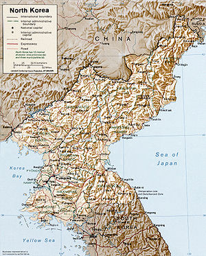
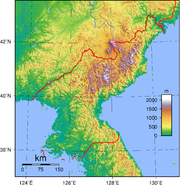
Geography of North Korea
- North Korea is: a country
- Location:
- Northern HemisphereNorthern HemisphereThe Northern Hemisphere is the half of a planet that is north of its equator—the word hemisphere literally means “half sphere”. It is also that half of the celestial sphere north of the celestial equator...
and Eastern HemisphereEastern HemisphereThe Eastern Hemisphere, also Eastern hemisphere or eastern hemisphere, is a geographical term for the half of the Earth that is east of the Prime Meridian and west of 180° longitude. It is also used to refer to Europe, Asia, Africa, and Australasia, vis-à-vis the Western Hemisphere, which includes... - EurasiaEurasiaEurasia is a continent or supercontinent comprising the traditional continents of Europe and Asia ; covering about 52,990,000 km2 or about 10.6% of the Earth's surface located primarily in the eastern and northern hemispheres...
- AsiaAsiaAsia is the world's largest and most populous continent, located primarily in the eastern and northern hemispheres. It covers 8.7% of the Earth's total surface area and with approximately 3.879 billion people, it hosts 60% of the world's current human population...
- East AsiaEast AsiaEast Asia or Eastern Asia is a subregion of Asia that can be defined in either geographical or cultural terms...
- Korean PeninsulaKorean PeninsulaThe Korean Peninsula is a peninsula in East Asia. It extends southwards for about 684 miles from continental Asia into the Pacific Ocean and is surrounded by the Sea of Japan to the south, and the Yellow Sea to the west, the Korea Strait connecting the first two bodies of water.Until the end of...
- Korean Peninsula
- East Asia
- Asia
- Time zoneTime zoneA time zone is a region on Earth that has a uniform standard time for legal, commercial, and social purposes. In order for the same clock time to always correspond to the same portion of the day as the Earth rotates , different places on the Earth need to have different clock times...
: Korea Standard TimeKorea Standard TimeKorea Standard Time is the standard time zone in North and South Korea and is 9 hours ahead of UTC : i.e., when it is midnight UTC, it is 9 am Korea Standard Time. Korea does not currently observe daylight saving time but has experimented with it in the past...
(UTC+09) - Extreme points of North Korea
- High: Paektu-san 2744 m (9,003 ft)
- Low: Sea of JapanSea of JapanThe Sea of Japan is a marginal sea of the western Pacific Ocean, between the Asian mainland, the Japanese archipelago and Sakhalin. It is bordered by Japan, North Korea, Russia and South Korea. Like the Mediterranean Sea, it has almost no tides due to its nearly complete enclosure from the Pacific...
and Yellow SeaYellow SeaThe Yellow Sea is the name given to the northern part of the East China Sea, which is a marginal sea of the Pacific Ocean. It is located between mainland China and the Korean Peninsula. Its name comes from the sand particles from Gobi Desert sand storms that turn the surface of the water golden...
0 m
- Land boundaries: 1,673 km
- Northern Hemisphere
-
 Mainland China 1,416 km
 South Korea 238 km
 Russia 19 km
- Coastline: 2,495 km
- Population of North Korea: 23,790,000 - 47th most populous country
- Area of North Korea: 120,540 km2
- Atlas of North Korea
Environment of North Korea
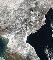
- Climate of North Korea
- Environmental issues in North Korea
- Ecoregions in North Korea
- Renewable energy in North Korea
- Geology of North Korea
- Protected areas of North Korea
- Biosphere reserves in North Korea
- National parks of North Korea
- Wildlife of North Korea
- Flora of North Korea
- Fauna of North Korea
- Birds of North Korea
- Mammals of North Korea
Natural geographic features of North Korea
- Islands of North KoreaIslands of KoreaIslands of Korea are listed below, grouped by provinces, and not including most uninhabited islands and islets.-Gyeongsangbuk-do:* Ulleungdo* Jukdo* Kwanundo* Liancourt Rocks -Inhabited:* Achado* Baegado* Baengnyeongdo* Boreumdo* Daeijakdo...
- Lakes of North KoreaLakes of KoreaMost of the lakes of Korea are artificial reservoirs, due to the country's rugged topography. Natural lakes include the crater lakes atop Baekdusan and Hallasan, the Upo wetland, and various lagoons along the coast of the Sea of Japan .-South Korea:...
- Mountains of North Korea
- Volcanoes in North Korea
- Rivers of North KoreaRivers of KoreaThe Korean peninsula is mainly mountainous along its east coast, so most of its river water flows west, emptying into the Yellow Sea. Some of these rivers flow through lakes en route to the coast, but these are all artificial reservoirs, as there are no natural lakes on the Korean mainland...
- Waterfalls of North Korea
- Valleys of North Korea
- List of World Heritage Sites in North Korea
Ecoregions of North Korea
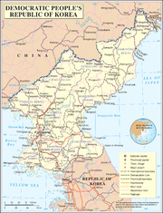
Administrative divisions of North Korea
- First-level divisions
- Second-level divisions
- Third-level divisions
- Second-level divisions
Provinces of North Korea
Provinces
Special Administrative Regions
Directly-governed cities
- Chagang Province (Chagang-do; 자강도; 慈江道)
- North Hamgyŏng Province (Hamgyŏng-pukto; 함경 북도; 咸鏡北道)
- South Hamgyŏng Province (Hamgyŏng-namdo; 함경 남도; 咸鏡南道)
- North Hwanghae Province (Hwanghae-pukto; 황해 북도; 黃海北道)
- South Hwanghae Province (Hwanghae-namdo; 황해 남도; 黃海南道)
- Kangwŏn Province (Kangwŏndo; 강원도; 江原道)
- North P'yŏngan Province (P'yŏngan-pukto; 평안 북도; 平安北道)
- South P'yŏngan Province (P'yŏngan-namdo; 평안 남도; 平安南道)
- Ryanggang Province (Ryanggang-do; 량강도; 兩江道)1
- Note:Sometimes also spelled as "Yanggang" in English.
- Kaesŏng Industrial RegionKaesong Industrial RegionKaesŏng Industrial Region is a special administrative industrial region of North Korea. It was formed in 2002 from part of Kaesŏng Directly Governed City.-Kaesŏng Industrial Park:...
(Kaesŏng Kongŏp Chigu; 개성 공업 지구; 開城工業地區) - Kŭmgangsan Tourist RegionKumgangsan Tourist RegionThe Kŭmgangsan Tourist Region is a special administrative region of North Korea. It was established in 2002 to handle South Korean tourist traffic to Kŭmgangsan ....
(Kŭmgangsan Kwan'gwang Chigu; 금강산 관광 지구; 金剛山觀光地區) - Sinŭiju Special Administrative RegionSinuiju Special Administrative RegionSinŭiju Special Administrative Region was a proposed special administrative region of North Korea, on the border with China. It was established in September 2002 in an area including parts of Sinŭiju and the surrounding area, in an attempt to introduce market economics, and is directly governed as...
(Sinŭiju T'ŭkbyŏl Haengjeonggu; 신의주 특별 행정구; 新義州特別行政區)
- P'yŏngyangPyongyangPyongyang is the capital of the Democratic People's Republic of Korea, commonly known as North Korea, and the largest city in the country. Pyongyang is located on the Taedong River and, according to preliminary results from the 2008 population census, has a population of 3,255,388. The city was...
(P'yŏngyang Chikhalsi; 평양 직할시; 平壤直轄市) - Rasŏn (Rajin-Sŏnbong)(Rasŏn (Rajin-Sŏnbong) Chikhalsi; 라선 (라진-선봉) 직할시; 羅先 (羅津-先鋒) 直轄市)
Second-level administrative districts of North Korea
| Associated First-level district | City(-ies) | County(-ies) | Workers' District(s) | District(s) | Ward(s) |
|---|---|---|---|---|---|
| P'yŏngyang Pyongyang Pyongyang is the capital of the Democratic People's Republic of Korea, commonly known as North Korea, and the largest city in the country. Pyongyang is located on the Taedong River and, according to preliminary results from the 2008 population census, has a population of 3,255,388. The city was... Directly Governed City |
N/A | 4 counties:
|
N/A | N/A | 19 wards |
| Rasŏn Directly Governed City | N/A | 1 county:
Sonbong Sonbong, formerly called Unggi , is a subdivision of the North Korean city of Rason. It is located at the northeastern extreme of North Korea, bordering Russia and China. It lies on Unggi Bay, an extension of the Sea of Japan . A uranium mine is allegedly located there, as is a 200 megawatt... |
N/A | N/A | 1 ward:
|
| Chagang Province | 3 cities:
Manpo Manp'o is a city of northwestern Chagang Province, North Korea. As of 1991, it had an estimated population of 100,893. It looks across the border to the city of Ji'an, Jilin province, China.-Geography:... Kanggye Kanggye is the provincial capital of Chagang, North Korea and has a population of 209,000. Because of its strategic importance, derived from its topography, it has been of military interest from the time of the Joseon Dynasty .-Geography:... Huichon Hŭich'ŏn is a city in the southern part of Chagang Province, North Korea. The population is 163,000 .-History:Hŭich'ŏn was formerly a small village, since the Korean War and an influx of government investment, it has become a base for electronics and machinery production for... |
15 counties:
Changgang Changgang is a kun, or county, in north-central Chagang province, North Korea. Originally part of Kanggye, it was made a separate county in 1949... Chasong Chasŏng is a county in Chagang Province, North Korea. The city is immediately south of the Chinese-North Korean border. Its approximate population to 7 km from the city center is 8,317. The average altitude is 1279 feet, or 389 meters. Nearby cities and towns include Haengjangp'yong and... Chonchon (North Korea) For other uses, see Chonchon Chonchon is a kun, or county, in central Chagang province, North Korea. Originally part of Kanggye, it was made a separate county in 1949. The terrain is high and mountainous; the highest point is Sungjoksan, 1984 m above sea level... Chosan Chosan is a kun, or county, in Chagang province, North Korea. It borders the People's Republic of China to the north.The terrain slopes downward from the Kangnam Mountains in the south to the Yalu River in the north. The highest peak is Namhaetaesan . Some 20% of the land is arable, with animal... Chunggang Chunggang is a kun, or county, in northern Chagang province, North Korea. It was originally part of Huchang county in Ryanggang, and for that reason older sources still identify it as being part of Huchang. The county seat was originally known as Chunggangjin , but is now known as Chunggang ŭp... Hwapyong Hwapyong is a kun, or county, in Chagang province, North Korea. It was incorporated as a new county as part of a general reorganization of local government in December 1952. Previously it had been part of Chasong and Huchang.... Kopung Kopung is a kun, or county, in Chagang province, North Korea. Prior to the division of Korea, it was part of Chosan county.-Geography:Most of Kopung is mountainous, but lower in the west. The Kangnam and [Chogyuryong ranges pass through the county. The chief streams are the Chungman River and the... Rangrim Rangrim is a kun, or county, on the eastern flank of Chagang province, North Korea. It was created in 1952 from portions of Changgang and Changjin, as part of a general reorganization of local government. Originally part of South Hamgyong, it was transferred to Chagang province in 1954... Ryongrim Ryongrim is a kun, or county, in southeastern Chagang Province, North Korea. It borders Rangrim, Changjin, Chonchon, Tongsin, Taehung, and Songgan counties. The county is mainly alpine territory... Sijung Sijung is a kun, or county, in Chagang province, North Korea. It borders Kanggye and Changgang to the east, Manpo to the north and west, and Wiwon to the south... Songgan Songgan is a kun, or county, in central Chagang province, North Korea. It borders Rangrim to the east, Wiwon to the west, Kanggye to the north and Chonchon and Ryongrim to the south... Songwon Songwon is a kun, or county, in southwestern Chagang province, North Korea. It borders Usi and Kopung counties to the north, Tongsin to the east, and Huichon to the south, as well as North Pyongan's Tongchang county to the west... Usi Usi is a kun, or county, in westernmost Chagang province, North Korea. It looks across the Yalu River into the People's Republic of China. Within North Korea, it borders Chosan and Kopung to the east, Songwon to the south, and North Pyongan's Pyoktong county to the west... Wiwon Wiwon is a kun, or county, in northern Chagang province, North Korea. It stands across the Yalu River from the People's Republic of China. It was originally part of North Pyongan province, but was annexed to Chagang in 1954... |
N/A | N/A | N/A |
| North Hamgyŏng Province | 3 cities:
Chongjin Ch'ŏngjin is the capital of North Korea's North Hamgyŏng Province and the country's third largest city. From 1960 to 1967 and again from 1977 to 1985, Ch'ŏngjin was administered separately from North Hamgyŏng as a Directly Governed City... Hoeryong Hoeryŏng is a city in North Hamgyŏng Province, North Korea. It is opposite Jilin Province, China, with the Tumen River in between. Sanhe , in Longjing prefecture, is the closest Chinese town across the river. Hoeryŏng is said to be the birthplace of Kim Il Sung's first wife and Kim Jong Il's... Kimchaek Kimch'aek, formerly Sŏngjin , is a city in North Hamgyong Province, North Korea. It has a population of 196,000... |
12 counties:
Hwasong (North Korea) Hwasong is a kun, or county, in North Hamgyong province, North Korea. Unlike many Korean districts which date from the Joseon Dynasty, Hwasong was created after liberation.... Hwadae Hwadae is a county in southern North Hamgyong province, North Korea, with an area of about 460 km² and a population of approximately 70,000. It adjoins the Sea of Japan on the east and south. By land, it adjoins Kimchaek and Kilchu to the west, and Myŏngch'ŏn to the north... Kilchu Kilju, sometimesromanized as Kilchu, is a county in North Hamgyong province, North Korea. The county seat is Kilju Town.-History:The area around Kilju was part of the ancient Goguryeo kingdom, and was long inhabited by various Jurchen tribes. In 1107 it was annexed by Goryeo, who gave it its... Musan Musan is a county in central North Hamgyong province, North Korea. It borders the People's Republic of China to the north, across the Tumen River. It is divided into one ŭp, six labor districts, and fifteen ri. The county seat is the town of Musan, Musan ŭp... Myongchon Myongchon or Myŏngch'ŏn is a kun, or county, in North Hamgyong province, North Korea. The Taepodong missile base is located here. In addition, the county is home to numerous hot springs.-External links:... Onsong Onsŏng is a county in North Hamgyong Province, North Korea, located near the border with China. The administrative center is the town of Onsong... Orang (North Korea) Orang is a kun, or county, in North Hamgyong province, North Korea. It is situated on the coast of the Sea of Japan . Originally part of Kyongsong county, Orang was created in 1952 following the division of Korea.-Physical features:... Puryong Puryong is a kun, or county, in North Hamgyong province, North Korea.Most of the county is mountainous, being traversed by the Hamgyong Range and its outlying spurs. The highest point is Kosŏngsan , 1,754 meters above sea level. Many other high peaks are also found in the county. The chief stream... Saebyol Kyongwon is a kun, or county, in North Hamgyong province, North Korea ,located at . It is bordered by the People's Republic of China to the north and east, Kyonghung to the southeast, Hoeryong to the southwest, and Onsong to the west.... Undok Undok is a kun, or county, in North Hamgyong province, North Korea. Formerly known as Kyŏnghŭng County , it was given its current name in 1977.... Yonsa Yŏnsa is a kun, or county, in North Hamgyong province, North Korea. It was created following the division of Korea, being split off from Musan county in the 1952 reorganization of local government.... |
N/A | N/A | N/A |
| South Hamgyŏng Province | 4 cities:
Hamhung Hamhŭng is North Korea's second largest city, and the capital of South Hamgyŏng Province. In late 2005, nearby Hŭngnam was made a ward within Hamhŭng-si. It has a population of 768,551 as of 2008.-Geography:... Hungnam Hŭngnam was the third largest city in North Korea.It is a port city on the eastern coast, in South Hamgyong Province, on the Sea of Japan . The city covers an area of 250 square kilometers... Sinpo Sinpo is a port city on the coast of the Sea of Japan in central South Hamgyong province, North Korea. According to the last available census, approximately 158,000 people reside here.-Weather:... Tanchon Tanchon or Tanch'ŏn is a city in northeastern South Hamgyong province, North Korea. It has a population of approximately 360,000. Tanchon borders the Sea of Japan , into which the Namdae River flows.-Economy:Mining... |
15 counties:
Hamju -Physical features:The county's highest point is Norabong. The chief river is the Sangchon River . Aside from the coastal area, Hamju is mountainous throughout. It is cold, but is distinguished by the occurrence of foehn winds in the upland areas... Hochon Hochon is a county in South Hamgyong province, North Korea. It was created after the division of Korea, from portions of Tanchon and Pungsan.Most of the county is steep and mountainous, and particularly so in the southeast. There are numerous high peas... Hongwon Hongwon is a county in South Hamgyong province, North Korea. It is flanked by the Sea of Japan to the south, and by the Hamgyong Mountains to the north.-Physical features:... Kowon Kowon is a county in South Hamgyong province, North Korea. It lies at the southern tip of the province.-Physical features:The highest point is Palbongsan. The western reaches of the county are high and mountainous, while the east is a low-lying plain. Major rivers and streams include the Chontan... Kumya Kumya is a county in South Hamgyong province, North Korea. It borders the Sea of Japan to the east.-Physical features:To the west, there are high mountains but the eastern portion of the county is flat. The highest peak is Chongamsan . The chief river is the Ryonghung. Several islands are... Pujon Pujŏn is a city in northern South Hamgyong province, North Korea.In historical contexts, Pujŏn is sometimes known as Fusen, according to its Japanese pronunciation.-External links:... Pukchong Pukchong is a county in eastern South Hamgyong province, North Korea. It borders the Sea of Japan to the south. Away from the coast, it is entirely mountainous. The Hamgyong Mountains traverse the county. The highest point is Komdoksan. Chief streams include the Namdaechon and Pochonchon... Ragwon Ragwon is a county in South Hamgyong province, North Korea. It borders the Sea of Japan to the south and east. Most of the county is mountainous. The highest point is Chonchubong . The coastal area includes the islands such as Chonchodo and Chintudo . Forestland occupies about 75% of the... Riwon Riwon is a county in South Hamgyong province, North Korea. It is located at the province's northeastern tip, and borders the Sea of Japan to the southeast.-Physical features:... Sinhung Sinhung is a mountainous county in South Hamgyong province, North Korea. It is traversed by the Hamgyong and Palbong ranges. The highest point is Chailbong. There are also lowland plains, where the temperatures are quite different from the mountains. The chief streams are the Sangchon and Pujon... Toksong Toksong is a county in South Hamgyong province, North Korea. It is largely mountainous, but the southern area is low-lying. The Pujonryong, Taedok, and Kodubong ranges pass through the county. The highest point is Huisabong. Major streams include the Kosochon , Konpachon , and Tongpalryongchon... Yonggwang Yonggwang is a county in South Hamgyong province, North Korea. It was originally part of Hamju County, from which it was separated in a general reorganization of local government in 1952. It is the site of one of the steles erected by Jinheung of Silla in the 6th century.The county is primarily... Yodok Yodok is a county in South Hamgyong province, North Korea. Originally part of Yonghung County, it became a separate entity as part of the 1952 reorganization of local government.-Physical features:... |
1 district:
Sudong Sudong-ku is a county in South Hamgyong province, North Korea. It was formed from part of Kowon County in December 1990. Sudong is the site of a major coal seam first discovered in 1918. The Pyongra Line railroad passes through the district.-See also:... |
1 worker's district:
|
N/A |
| North Hwanghae Province | 3 cities:
Sariwon Sariwŏn is the capital of North Hwanghae Province, North Korea. The city's population is estimated to be 310,100 people.-Healthcare:Sariwon has the only pediatric hospital in the entire region; it serves 16 districts and 500,000 children and teens annually.... Kaesong Kaesŏng is a city in North Hwanghae Province, southern North Korea , a former Directly Governed City, and the capital of Korea during the Koryo Dynasty. The city is near Kaesŏng Industrial Region and it contains the remains of the Manwoldae palace. It was formally named Songdo while it was the... Songrim Songrim is a city on the Taedong River in North Hwanghae Province, North Korea. It had a population of 100,000 in 1991.The city was originally named Solme. Iron works began to be developed during the Japanese colonial period of Korea. Before Korean independence Songrim was known as Kyŏmip'o .It... |
16 counties:
Changpung Changp'ung is a county in North Hwanghae province, North Korea. Formerly part of the Kaesong urban area, the county was merged with North Hwanghae when Kaesong was demoted in 2003... Hwangju -Geography:Hwangju is bordered to the northwest by Sariwŏn, to the northeast by Songrim and Kangnam, to the southwest by Yŏnt'an, to the south by Pongsan, and to the southeast by Ŭnch'ŏn-History:... Kaepung Kaep'ung is a county in North Hwanghae province, North Korea. Formerly part of the Kaesong urban area, the county was merged with North Hwanghae when Kaesong was demoted in 2003... Kumchon Kŭmch'ŏn is a county in North Hwanghae province, North Korea. It has a population of 68,216.-Geography:Kumchon is bordered to the west by Kaesong, to the south by Kaepung, to the northwest by Tosan, and to the north by Mt. Pakbong and Singye county. It is bordered to the east by the Ryesong River,... Pongsan Pongsan is a county in North Hwanghae province, North Korea.The name is spelled with a "B" according to the McCune–Reischauer form of romanization or spelled with a "P" according to the Revised Romanization of Korean.-Transport:... Pyongsan -Transport:Pyongsan county is served by the following railway stations:* Pyongsan Station, Pyongbu Line and Chongnyon Ichon Line* Mulgae Station, Pyongbu Line* Taebaeksansong Station, Pyongbu Line* Kyejong Station, Pyongbu Line... Rinsan Rinsan is a county in North Hwanghae province, North Korea.... Singye -Transport:Singye Station is on the Chongnyon Ichon Line railway.... * Sinp'yŏng Sinpyong Sinpyong is a county in North Hwanghae province, North Korea.... Sohung Sohung is a county in North Hwanghae province, North Korea.... Tosan (North Korea) Tosan is a county in North Hwanghae province, North Korea.... Unpa Unpa is a county in North Hwanghae province, North Korea.... Yonsan Yonsan is a county in North Hwanghae province, North Korea.... Yontan Yontan is a county in North Hwanghae province, North Korea.... |
N/A | N/A | N/A |
| South Hwanghae Province | 1 city:
Haeju Haeju is a city located in South Hwanghae Province near Haeju Bay in North Korea. It is the administrative centre of South Hwanghae Province. As of 2000, the population of the city is estimated to be 236,000. At the beginning of 20th century, it became a strategic port in Sino-Korean trade... |
19 counties:
Chaeryong -Geography:Located on the Chaeryŏng River, the county is bordered to the west by Anak and Sinch'ŏn, to the south by Sinwŏn, and to the east by Ŭnp'a, Pongsan and Sariwŏn in North Hwanghae Province.-History:... * Changyŏn Changyon -Geography:Changyŏn is bordered to the north by Kwail and Songhwa, to the east by Samch'ŏn and T'aet'an, to the sough by Ryongyŏn, and to the west by the Yellow Sea. Most of the land in Changyŏn is composed of flat plains, with mountains forming its borders. The highest point is Mt. Pult'a, at 609... Chongdan Chongdan is a county in South Hwanghae province, North Korea.... Kangryong -Geography:Kangryŏng is bordered to the north by Pyŏksŏng, to the west by Ongjin, to the east by the Bay of Haeju and to the south by the Korea Bay. The county is situated on the western half of the Ongjin Peninsula, and most of the land is rocky and hilly with many coves and little flat land... Kwail Kwail is a kun, or county, in South Hwanghae province, North Korea. It faces the Yellow Sea to the west.The economy of the county is based on the production of fruit. Kwail County was created in 1967 from part of Songhwa County, with the intention of making the entire cultivated area of the county... Ongjin, South Hwanghae Ongjin is a county in southern South Hwanghae province, North Korea. It is located on the Ongjin Peninsula, which projects into the Yellow Sea.- History :... Pongchon Pongchon County , South Hwanghae Province, DPRK. Formerly known as Pyongchon County , this county was split from Pyongsan County in 1952. In 1990, it was given its current name.... Pyoksong Pyoksong is a county in South Hwanghae province, North Korea.... Ryongyon Ryongyon is a county in western South Hwanghae province, North Korea. Its Yellow Sea coast is known for its natural beauty and as an important habitat for plants and birds... Samchon Samchon is a county in South Hwanghae province, North Korea.... Sinchon Sinchon or Sinchon-dong is a neighbourhood and a judicial dong in Seodaemun-gu in Seoul, South Korea.... Sinwon Sinwon is a county in South Hwanghae province, North Korea.... Songhwa Songhwa is a county in South Hwanghae province, North Korea.Joint a Pungchen at 1909 AD-poeple:*Pungchen Im clan*Im Kkok-jeong, leader of a peasant rebellion in Hwanghae Province... Taetan Taetan is a county in South Hwanghae province, North Korea.... Unryul Unryul is a county in South Hwanghae province, North Korea.... Unchon Unchon is a county in South Hwanghae province, North Korea.... |
N/A | N/A | N/A |
| Kangwŏn Province | 2 cities:
Munchon Munch'ŏn is a North Korean city located in Kangwŏn Province. It lies on the coast of the Sea of Japan and borders Wonsan.-Geography:... Wonsan Wŏnsan is a port city and naval base in southeastern North Korea. It is the capital of Kangwŏn Province. The population of the city is estimated to have been 331,000 in 2000. Notable people from Wŏnsan include Kim Ki Nam, diplomat and Secretary of the Workers' Party.- History :The original name of... |
15 counties:
Anbyon Anbyon is a kun, or county, in Kangwon province, North Korea. Originally included in South Hamgyong province, it was transferred to Kangwon province in a September 1946 reshuffling of local government.-Physical features:... Changdo Changdo is a kun, or county, in Kangwon province, North Korea. Originally part of Kimhwa, it was split off as a separate county in 1952.Changdo lies to the west of the Taebaek Mountains, in the Ryongso region of Kangwon, but is nonetheless quite rugged. The highest point is Okpatbong , 1240 m... Chonnae Chonnae is a kun, or county, in Kangwon province, North Korea. Originally part of Munchon, it was made a separate county as part of the general reorganization of local government in December 1952.-Physical features:... Hoeyang Hoeyang is a kun, or county, in Kangwon province, North Korea. It was established in a general reorganization of local government in 1952.... Ichon (North Korea) Ichon is a kun, or county, in northern Kangwon province, North Korea. The terrain is predominantly high and mountainous; the highest point is Myongidoksan, 1,585 meters above sea level. The county's borders run along the Masikryong and Ryongam ranges. The chief stream is the Rimjin... Kimhwa Kimhwa is a kun, or county, in Kangwon province, North Korea. It is primarily mountainous, but the county's southeastern region is low-lying.... Kosong Kosong is a kun, or county, in Kangwon province, North Korea. It lies in the southeasternmost corner of North Korea, immediately north of the Korean Demilitarized Zone. Prior to the end of the Korean War in 1953, it made up a single county, together with what is now the South Korean county of the... Kumgang County Kumgang County is a kun, or county, in Kangwon province, North Korea. Kumgang lies immediately north of the Korean Demilitarized Zone. It was formed in 1952 from portions of Hoeyang, Yanggu, and Inje, as part of a general reorganization of local government, and stretches out from north to south... Poptong Poptong is a kun in the Kangwon province, North Korea. It lies between the Masikryong and Ahobiryong ranges, and 90% of the county is more than 400 meters above sea level. The highest point is Turyusan. Only 5% of this rugged county consists of ground level. The chief streams are the Imjin River,... Pyonggang Pyonggang is a kun, or county, in Kangwon province, North Korea. It borders Sepo to the north, Chorwon to the south, Ichon to the west, and Changdo to the east.-Physical features:... Sepo Sepo is a kun, or county, in Kangwon province, North Korea. It was created as a separate entity following the division of Korea.-Physical features:... Tongchon Tongchon is a kun, or county, in Kangwon province, North Korea. It abuts the Sea of Japan to the north and east. Famous people from Tongchon include former Hyundai chairman Chung Ju-yung, who is believed to have been born there.... |
N/A | N/A | N/A |
| North P'yŏngan Province | 3 cities:
Sinuiju Sinŭiju is a city in North Korea, neighboring with Dandong City, China via international border and is the capital of North P'yŏngan Province... Kusong Kusŏng is a coterminous city in central North Pyongan province, North Korea. It borders Taegwan to the north, Taechon to the east, Kwaksan and Chongju to the south, and Chonma to the north. The highest point is Chongryongsan . The year-round average temperature is 8.2 °C, with a January average... |
22 counties:
Changsong Changsong is a kun, or county, in northern North Pyongan province, North Korea. It is bordered by Pyoktong to the east, Tongchang and Taegwan to the south, Sakchu to the west; to the north, it faces China across the Yalu River.... Cholsan Cholsan is a kun, or county, in North Pyongan province, North Korea. It occupies the Cholsan Peninsula, which juts into the Yellow Sea. Cholsan borders Yomju and Tongrim to the north, and is bounded on all other sides by water.... Chonma Chonma is a kun, or county, in northwestern North Pyongan province, North Korea. It borders Kusong and Taegwan to the east, Sonchon and Tongrim to the south, Uiju and Pihyon to the west, and Sakchu to the north. It was created in 1952 from parts of Kusong and Uiju.There are abundant mountains,... Hyangsan Hyangsan is a kun, or county, in North Pyongan province, North Korea. It was established, following the division of Korea, from portions of Nyongbyon county. The area of Myohyangsan mountain, which stands on the county's border, has been developed as a tourist destination... , Kujang Kujang Kujang is a kun, or county, in southeastern North Pyongan province, North Korea. It was created in 1952 from part of Nyongbyon county, as part of a nationwide reorganization of local government... Kwaksan Kwaksan is a kun, or county, in coastal southern North Pyongan province, North Korea. It faces the Yellow Sea to the south. By land, it is bordered by Kusong in the north, Chongju in the east, and Sonchon in the west.... Nyongbyon Nyongbyon-gun, alternatively Yongbyon-gun, is a county in North Pyongan province, North Korea. It borders the cities of Kaech'on and Anju, and covers an area of 504 km².... Pakchon Pakchon is a kun, or county, in southern North Pyongan province, North Korea. It is bordered to the north by Taechon, to the east and southeast by Nyongbyon, and to the west by Unjon. To the south, it looks across the Chongchon River at Anju city and Mudok county in South Pyongan province... Pihyon Pihyon, also spelled Phihyon, is a kun, or county, in northwestern North Pyongan province, North Korea. It is bounded to the north by Uiju, to the east by Chonma, to the south by Yomju and Tongrim, and to the west by Ryongchon and the large city of Sinuiju... Pyoktong Pyoktong is a kun, or county, in northern North Pyongan province, North Korea. It lies in the valley of the Yalu River, and borders China to the north. Within North Korea, it is bounded by Tongchang in the south, Changsong in the west, and Usi county in Chagang province to the east... Ryongchon Ryongch'ŏn is a kun in North P'yǒngan Province, North Korea, at the mouth of the Yalu River. The county seat is Ryongchŏn-ŭp, about from the border with China... Sakchu Sakchu is a kun, or county, in northern North Pyongan province, North Korea. It lies on the Yalu River, bordering the People's Republic of China to the north. Within North Korea, it borders Changsong to the east, Chonma and Taegwan to the south, and Uiju to the west.The Kangnam Mountains rise in... Sindo (North Korea) Sindo is a kun in the North Pyongan province of North Korea. Most of the county consists of Pidansom, an island in the estuary of the Yalu River... Sonchon Sonchon is a kun, or county, on the coast of the Yellow Sea in west-central North Pyongan province, North Korea. To the north it borders Chonma, to the east Kusong and Kwaksan, and to the west Tongrim; to the south, it borders nothing but the sea... Taechon Taechon, also spelled Thaechon, is a kun, or county, in central North Pyongan province, North Korea. It borders Taegwan and Tongchang to the north, Unsan and Nyongbyon to the east, Pakchon and Unjon to the south, and Kusong to the west.... Taegwan Taegwan is a kun, or county, in northeastern North Pyongan province, North Korea. It lies in the province's interior, and is bounded by Tongchang on the east, Kusong and Taechon to the south, Chonma to the west, and Changsong and Sakchu to the north... Tongchang Tongchang is a kun, or county, in northeastern North Pyongan province, North Korea. It borders Pyoktong and Chagang's Usi county to the north, Unsan and Songwon to the east, Taechon to the south, and Changsong and Taegwan to the west.... Tongrim Tongrim is a kun, or county, in coastal southwestern North Pyongan province, North Korea. It borders Pihyon and Chonma to the north, Sonchon to the east, Cholsan to the southwest, and Yomju to the west. To the south, it looks out on the Yellow Sea.... Uiju Ŭiju is a kun, or county, in North Pyongan Province, North Korea. The county has an area of 420 km², and a population of 110,018 .-Location:... Unjon Unjon is a kun, or county, in North Pyongan province, North Korea. It borders Taechon to the north, Pakchon to the east and southeast, and Chongju to the north. To the south, it looks out on the Yellow Sea... Unsan Unsan is a kun, or county, in eastern North Pyongan province, North Korea. Within the province, it borders Hyangsan in the east, Kujang and Nyongbyon in the south, and Tongchang and Taechon in the west... Yomju Yomju is a kun, or county, in northwestern North Pyongan province, North Korea, on the coast of the Yellow Sea. It is bordered by Ryongchon and Pihyon to the north, Tongrim to the east, and Cholsan to the south; to the west lies the ocean... |
N/A | N/A | N/A |
| South P'yŏngan Province | 1 special city:
5 cities:
|
1 district:
|
2 workers' districts:
Tukchang Tukchang is an district of the province of South Pyongan in North Korea.Tukchang was established as its own administrative area after separating from Pukchang in 1995.-Administrative districts:... Ungok Ungok is an district of the province of South Pyongan in North Korea.Tukchang was established as its own administrative area after separating from Anju in 1997.-Administrative districts:... |
19 counties:
Chungsan Chungsan is a county of the province of South Pyongan in North Korea.-Administrative districts:The district is split into one ŭp and 17 ri .-External links:... Hoechang Hoechang-gun is a county in South Pyongan province, North Korea.-History:Before 1945, most of the territory that now comprises Hoechang was part of neighboring Songchon county... Maengsan Maengsan is a county of the province of South Pyongan in North Korea.-Administrative districts:The district is split into one ŭp and 24 ri .-External links:... Mundok Mundeok is a county of the province of South Pyongan in North Korea.-Administrative districts:The district is split into one ŭp , one rodongjagu and 21 ri .-External links:... Onchon Onchon is a county of the province of South Pyongan in North Korea.-Administrative districts:The district is split into one ŭp , five rodongjagu and 14 ri .-External links:... Pukchang Pukchang is a county of the province of South Pyongan in North Korea.In this county is the country's largest power station- Pukchang coal power station - with a production capacity of up to 1600 MW.-Administrative districts:... Pyongwon Pyongwon is a county of the province of South Pyongan in North Korea.-Administrative districts:The district is split into one ŭp , two rodongjagu and 29 ri .-External links:... Songchon Songchon is a county of the province of South Pyongan in North Korea.-Administrative districts:The district is split into one ŭp , three rodongjagu and 20 ri .-External links:... Sukchon Sukchon is a county of the province of South Pyongan in North Korea.-Administrative districts:The district is split into one ŭp , one rodongjagu and 20 ri .-External links:... Taehung Taehung is a kun, or county, in the northeastern corner of South Pyongan province, North Korea. It is bordered to the north by Yongrim and Changjin, to the east by Yonggwang and Hamju, to the south by Yodok and Chongpyong, and to the west by Yongwon and Tongsin... Unsan Unsan is a kun, or county, in eastern North Pyongan province, North Korea. Within the province, it borders Hyangsan in the east, Kujang and Nyongbyon in the south, and Tongchang and Taechon in the west... Yangdok Yangdok is a county of the province of South Pyongan in North Korea.-Administrative districts:The district is split into one ŭp and 18 ri .-External links:... |
N/A |
| Ryanggang Province | 1 city:
Hyesan Hyesan is a city in the northern part of the northern Ryanggang province of North Korea. It is a hub of river transportation as well as a product distribution centre. It is also the administrative centre of Ryanggang Province... |
11 counties:
Kapsan Kapsan is a kun, or county, in Ryanggang province, North Korea. During the Chosŏn Dynasty, officials who had fallen into disfavor were often sent into internal exile there.... Kimjongsuk Kimjŏngsuk is a kun, or county, in Ryanggang province, North Korea, along the Yalu River. Originally part of Samsu, the county was made a separate entity in 1981. It was named after Kim Jong-suk, the mother of Kim Jong-il.... Kimhyonggwon Kimhyŏnggwŏn is a kun, or county, in southeastern Ryanggang province, North Korea. It borders South Hamgyong to the south. Previously known as Pungsan, it was renamed by Kim Il Sung in 1990. He named it after his uncle, Kim Hyong Kwon... Kimhyongjik Kimhyŏngjik County is a kun of Ryanggang Province, North Korea. Formerly known as Huch'ang County, it was renamed in 1988 after Kim Il Sung's father, Kim Hyŏng-jik.The 2004 Ryanggang explosion occurred at Yongjo-ri in this county.-Geography:... Paegam Paegam is a kun, or county, in Ryanggang province, North Korea. The terrain is mountainous, as Paegam lies atop the Paektu Plateau, site of Korea's highest mountains. The Hamgyong and Machonryong ranges pass through the county; the highest point is Kwesangbong. There are many streams; the chief... Samjiyon Samjiyŏn, or Samjiyŏn-kun, is a district in Ryanggang province, North Korea. It has its own airport. It takes its name from three lakes in the county, which are known as the Samjiyŏn... Samsu Samsu is a kun, or county, in Ryanggang province, North Korea. Prior to 1954, it was part of South Hamgyong province.On its northern border, Samsu shares the Yalu River with China. It also shares a border with the province of North Pyongan. To the south, it occupies the northern tip of the Kaema... Taehongdan Taehongdan is a kun, or county, in Ryanggang province, North Korea. It was originally part of Musan.To the north, Taehongdan looks across the Tumen River at China. It stands on the northwest edge of the Paekmu Plateau. The highest of its many peaks is Changchongsan . The chief river is the... Unhung Unhŭng is a kun, or county, in Ryanggang province, North Korea. It was created following the division of Korea from portions of Hyesan and Kapsan.... |
N/A | N/A | N/A |
| Kaesŏng Industrial Region | N/A | N/A | N/A | N/A | N/A |
| Kŭmgangsan Tourist Region | N/A | N/A | N/A | N/A | N/A |
| Sinŭiju Special Administrative Region | N/A | N/A | N/A | N/A | N/A |
Municipalities of North Korea
- Capital of North Korea: Pyongyang
- Cities of North Korea
Government and politics of North Korea
- Main article: Government of North KoreaGovernment of North KoreaThe North Korean government is the executive branch of the state, according to the Constitution of North Korea. In practice, the highest decisions are made by the National Defence Commission of North Korea which is led by its Chairman Kim Jong-il....
and Politics of North KoreaPolitics of North KoreaThe politics of North Korea take place within a nominally democratic multi-party system within the framework of the official state philosophy, Juche, a concept created by the founder of the North Korean state, Kim Il-sung, and his son and successor as leader, Kim Jong-il. In practice, North Korea...
- Form of governmentForm of governmentA form of government, or form of state governance, refers to the set of political institutions by which a government of a state is organized. Synonyms include "regime type" and "system of government".-Empirical and conceptual problems:...
: - Capital of North Korea: Pyongyang
- Elections in North KoreaElections in North KoreaElections in North Korea are held every five years. At the national level, North Koreans elect a legislature, the Supreme People's Assembly . In addition to the Supreme People's Assembly, the people elect representatives to city, county, and provincial "people's assemblies".All seats were won by...
- (specific elections)
- Political parties in North Korea
- Political scandals of North Korea
- Taxation in North Korea
Executive branch of the government of North Korea
- Head of stateHead of StateA head of state is the individual that serves as the chief public representative of a monarchy, republic, federation, commonwealth or other kind of state. His or her role generally includes legitimizing the state and exercising the political powers, functions, and duties granted to the head of...
: President of North KoreaPresident of North KoreaThe President of the Democratic People's Republic of Korea was established in the Constitution of North Korea, 1972. Until then, Kim Il-sung, the ruler of North Korea, used the posts Premier and General Secretary of the Workers' Party of Korea...
, - Head of governmentHead of governmentHead of government is the chief officer of the executive branch of a government, often presiding over a cabinet. In a parliamentary system, the head of government is often styled prime minister, chief minister, premier, etc...
: Prime Minister of North Korea, - Cabinet of North Korea
Legislative branch of the government of North Korea
- Parliament of North Korea (unicameral)
Judicial branch of the government of North Korea
- Supreme Court of North Korea
Foreign relations of North Korea
- Diplomatic missions in North Korea
- Diplomatic missions of North KoreaDiplomatic missions of North KoreaThis is a list of diplomatic missions of North Korea. The Democratic People's Republic of Korea is one of the most isolated countries in the world, with limited ties to the international community....
- North Korea–South Korea relations
International organization membership
The Democratic People's Republic of Korea is a member of:- Association of Southeast Asian Nations Regional Forum (ARF)
- Food and Agriculture OrganizationFood and Agriculture OrganizationThe Food and Agriculture Organization of the United Nations is a specialised agency of the United Nations that leads international efforts to defeat hunger. Serving both developed and developing countries, FAO acts as a neutral forum where all nations meet as equals to negotiate agreements and...
(FAO) - Group of 77Group of 77The Group of 77 at the United Nations is a loose coalition of developing nations, designed to promote its members' collective economic interests and create an enhanced joint negotiating capacity in the United Nations. There were 77 founding members of the organization, but the organization has...
(G77) - International Civil Aviation OrganizationInternational Civil Aviation OrganizationThe International Civil Aviation Organization , pronounced , , is a specialized agency of the United Nations. It codifies the principles and techniques of international air navigation and fosters the planning and development of international air transport to ensure safe and orderly growth...
(ICAO) - International Federation of Red Cross and Red Crescent SocietiesInternational Federation of Red Cross and Red Crescent SocietiesThe International Federation of Red Cross and Red Crescent Societies is a humanitarian institution that is part of the International Red Cross and Red Crescent Movement along with the ICRC and 186 distinct National Societies...
(IFRCS) - International Fund for Agricultural DevelopmentInternational Fund for Agricultural DevelopmentThe International Fund for Agricultural Development , a specialized agency of the United Nations, was established as an international financial institution in 1977 as one of the major outcomes of the 1974 World Food Conference. IFAD is dedicated to eradicating rural poverty in developing countries...
(IFAD) - International Hydrographic OrganizationInternational Hydrographic OrganizationThe International Hydrographic Organization is the inter-governmental organisation representing the hydrographic community. It enjoys observer status at the UN and is the recognised competent authority on hydrographic surveying and nautical charting...
(IHO) - International Maritime OrganizationInternational Maritime OrganizationThe International Maritime Organization , formerly known as the Inter-Governmental Maritime Consultative Organization , was established in Geneva in 1948, and came into force ten years later, meeting for the first time in 1959...
(IMO) - International Olympic CommitteeInternational Olympic CommitteeThe International Olympic Committee is an international corporation based in Lausanne, Switzerland, created by Pierre de Coubertin on 23 June 1894 with Demetrios Vikelas as its first president...
(IOC) - International Organization for StandardizationInternational Organization for StandardizationThe International Organization for Standardization , widely known as ISO, is an international standard-setting body composed of representatives from various national standards organizations. Founded on February 23, 1947, the organization promulgates worldwide proprietary, industrial and commercial...
(ISO) - International Red Cross and Red Crescent MovementInternational Red Cross and Red Crescent MovementThe International Red Cross and Red Crescent Movement is an international humanitarian movement with approximately 97 million volunteers, members and staff worldwide which was founded to protect human life and health, to ensure respect for all human beings, and to prevent and alleviate human...
(ICRM) - International Telecommunication UnionInternational Telecommunication UnionThe International Telecommunication Union is the specialized agency of the United Nations which is responsible for information and communication technologies...
(ITU) - International Telecommunications Satellite OrganizationInternational Telecommunications Satellite OrganizationThe International Telecommunications Satellite Organization is an intergovernmental organisation charged with overseeing the public service obligations of Intelsat.-External links:*...
(ITSO)
- Inter-Parliamentary Union (IPU)
- Nonaligned Movement (NAM)
- United NationsUnited NationsThe United Nations is an international organization whose stated aims are facilitating cooperation in international law, international security, economic development, social progress, human rights, and achievement of world peace...
(UN) - United Nations Conference on Trade and DevelopmentUnited Nations Conference on Trade and DevelopmentThe United Nations Conference on Trade and Development was established in 1964 as a permanent intergovernmental body. It is the principal organ of the United Nations General Assembly dealing with trade, investment, and development issues....
(UNCTAD) - United Nations Educational, Scientific, and Cultural Organization (UNESCO)
- United Nations Industrial Development OrganizationUnited Nations Industrial Development OrganizationThe United Nations Industrial Development Organization , French/Spanish acronym ONUDI, is a specialized agency in the United Nations system, headquartered in Vienna, Austria...
(UNIDO) - Universal Postal UnionUniversal Postal UnionThe Universal Postal Union is an international organization that coordinates postal policies among member nations, in addition to the worldwide postal system. The UPU contains four bodies consisting of the Congress, the Council of Administration , the Postal Operations Council and the...
(UPU) - World Federation of Trade UnionsWorld Federation of Trade UnionsThe World Federation of Trade Unions was established in 1945 to replace the International Federation of Trade Unions. Its mission was to bring together trade unions across the world in a single international organization, much like the United Nations...
(WFTU) - World Health OrganizationWorld Health OrganizationThe World Health Organization is a specialized agency of the United Nations that acts as a coordinating authority on international public health. Established on 7 April 1948, with headquarters in Geneva, Switzerland, the agency inherited the mandate and resources of its predecessor, the Health...
(WHO) - World Intellectual Property OrganizationWorld Intellectual Property OrganizationThe World Intellectual Property Organization is one of the 17 specialized agencies of the United Nations. WIPO was created in 1967 "to encourage creative activity, to promote the protection of intellectual property throughout the world"....
(WIPO) - World Meteorological OrganizationWorld Meteorological OrganizationThe World Meteorological Organization is an intergovernmental organization with a membership of 189 Member States and Territories. It originated from the International Meteorological Organization , which was founded in 1873...
(WMO) - World Tourism OrganizationWorld Tourism OrganizationThe World Tourism Organization , based in Madrid, Spain, is a United Nations agency dealing with questions relating to tourism. It compiles the World Tourism rankings. The World Tourism Organization is a significant global body, concerned with the collection and collation of statistical information...
(UNWTO)
North Korea is 1 of only 7 U.N. members which is not a member of the Organization for the Prohibition of Chemical Weapons.
Law and order in North Korea
- Capital punishment in North KoreaCapital punishment in North KoreaCapital punishment is a legal form of punishment in North Korea and is used for many offences, such as armed robbery, murder, embezzlement, treason, espionage, drugs trafficking and manufacturing, tax fraud, mutiny, desertion, political dissidence, defection, consumption of media not approved by...
- Constitution of North KoreaConstitution of North KoreaThe Socialist Constitution of the Democratic People's Republic of Korea is the constitution of the Democratic People's Republic of Korea , commonly known as North Korea.Previous constitutions were adopted in 1948, 1972, 1992, and 1998...
- Crime in North Korea
- Human rights in North KoreaHuman rights in North KoreaThe human rights record of North Korea is extremely hard to fully assess due to the secretive and closed nature of the country. The North Korean government makes it very difficult for foreigners to enter the country and strictly monitors their activities when they do...
- LGBT rights in North Korea
- Freedom of religion in North KoreaFreedom of religion in North KoreaIn North Korea, the Constitution provides for "freedom of religious belief"; however, in practice the Government severely restricts religious freedom, including organized religious activity, except that which is supervised tightly by officially recognized groups linked to the Government...
- Law enforcement in North KoreaLaw enforcement in North KoreaThe Ministry of Public Security and the State Security Department are responsible for internal security in North Korea. Although both are government organs, they are tightly controlled by the party apparatus through the Justice and Security Commission and the penetration of their structures by the...
Military of North Korea
- Command
- Commander-in-chiefCommander-in-ChiefA commander-in-chief is the commander of a nation's military forces or significant element of those forces. In the latter case, the force element may be defined as those forces within a particular region or those forces which are associated by function. As a practical term it refers to the military...
:- Ministry of Defence of North Korea
- Commander-in-chief
- Forces
- Army of North Korea
- Navy of North Korea
- Air Force of North Korea
- Special forces of North Korea
- Military history of North Korea
- Military ranks of North Korea
History of North Korea
- Main article: History of North KoreaHistory of North KoreaThe history of North Korea formally begins with the establishment of the Democratic People's Republic of Korea in 1948 in the aftermath of division of Korea.-The early years:...
, Timeline of the history of North Korea, and Current events of North Korea
- Economic history of North Korea
- Military history of North Korea
Culture of North Korea
- Architecture of North Korea
- Cuisine of North Korea
- Languages of North Korea
- Media in North Korea
- National symbols of North Korea
- Coat of arms of North KoreaCoat of arms of North KoreaThe National Emblem of the Democratic People’s Republic of Korea bears the design of the Supung dam under Baekdu Mountain and bearing the beaming light of a five-pointed red star, with ears of rice forming an oval frame, bound with a red ribbon bearing the inscription "The Democratic People's...
- Flag of North KoreaFlag of North KoreaThe flag of North Korea was adopted on September 8, 1948, as the national flag and ensign. The red star of Communism can be seen on this flag on a white disc. The flag was adopted in 1948, when Northern portion of Korea became a Communist state. The traditional Korean flag was red, white, and blue...
- National anthem of North Korea
- Coat of arms of North Korea
- People of North Korea
- Prostitution in North KoreaProstitution in North KoreaProstitution in North Korea is illegal, and according to the North Korean government does not exist, but it is still practiced discreetly.- State prostitution :The North Korean government engages in forced prostitution...
- Public holidays in North KoreaPublic holidays in North KoreaThis is a list of Public holidays in North Korea. See also the Korean calendar for a list of traditional holidays....
- Records of North Korea
- Religion in North KoreaReligion in North KoreaTraditionally Religion in North Korea primarily consists of Buddhism and Confucianism and to a lesser extent Korean shamanism and syncretic Chondogyo. Since the arrival of Europeans in the 18th century, there is a Christian minority...
- Buddhism in North Korea
- Christianity in North Korea
- Hinduism in North Korea
- Islam in North Korea
- List of World Heritage Sites in North Korea
Art in North Korea
- Art in North Korea
- Cinema of North Korea
- Literature of North Korea
- Music of North KoreaMusic of North KoreaAfter the division of Korea in 1951, Korea was split, into the Democratic People's Republic of Korea or North and the Republic of Korea or South Korea...
- Television in North Korea
- Theatre in North Korea
Sports in North Korea
- Football in North KoreaFootball in North KoreaAssociation football in North Korea is governed by the DPR Korea Football Association , which was established in 1945. Due to the state's secrecy, attendances and popularity for club matches in the country are hard to gauge.-Governing Body:...
- North Korea at the OlympicsNorth Korea at the OlympicsNorth Korea first participated at the Olympic Games in 1964, appearing only in the Winter Olympic Games that year. Eight years later in 1972, the nation first participated at the Summer Olympic Games...
Economy and infrastructure of North Korea
- Economic rank, by nominal GDP (2007): 155th (one hundred and fifty fifth)
- Agriculture in North Korea
- Banking in North Korea
- National Bank of North Korea
- Communications in North KoreaCommunications in North KoreaCommunications in North Korea refers to the communication services available in North Korea. North Korea has yet to fully adopt mainstream internet technology due to its isolationist policies.-Telephone:...
- Internet in North KoreaInternet in North KoreaNorth Korea is almost completely isolated from the rest of the world and, while there is a public telephone network, there is no broadband data network. Satellite Internet coverage from BGAN and Thuraya is available, offering download speeds up to 492 kbit/s and upload speeds of 400 kbit/s;...
- Internet in North Korea
- Companies of North Korea
- Currency of North KoreaCurrencyIn economics, currency refers to a generally accepted medium of exchange. These are usually the coins and banknotes of a particular government, which comprise the physical aspects of a nation's money supply...
: WonNorth Korean wonThe won is the currency of North Korea . It is subdivided into 100 chon. The won is issued by the Central Bank of the Democratic People's Republic of Korea...
- ISO 4217ISO 4217ISO 4217 is a standard published by the International Standards Organization, which delineates currency designators, country codes , and references to minor units in three tables:* Table A.1 – Current currency & funds code list...
: KPWNorth Korean wonThe won is the currency of North Korea . It is subdivided into 100 chon. The won is issued by the Central Bank of the Democratic People's Republic of Korea...
- ISO 4217
- Economic history of North Korea
- Energy in North Korea
- Energy policy of North Korea
- Oil industry in North Korea
- Health care in North Korea
- Mining in North Korea
- North Korea Stock Exchange
- Tourism in North KoreaTourism in North KoreaOrganized by the state owned Korea International Travel Company, Tourism in North Korea is highly controlled by the government, and as such it is not a frequently visited destination — roughly 1,500 Western tourists visit North Korea each year, along with thousands of Asians. Tourists must go on...
- Transport in North Korea
- Airports in North Korea
- Rail transport in North KoreaRail transport in North KoreaRail transport in North Korea is provided by Korean State Railway which is the only rail operator in North Korea. It has a network of 5,200 km of track with 4,500 km in Standard gauge. There is a small narrow gauge railway in operation in Haeju peninsula...
- Roads in North Korea
- Water supply and sanitation in North Korea
See also
- Index of North Korea-related articles
- List of international rankings
- List of North Korea-related topics
- Member state of the United Nations
- Outline of AsiaOutline of AsiaThe following outline is provided as an overview of and topical guide to Asia:Asia – world's largest and most populous continent, located primarily in the eastern and northern hemispheres...
- Outline of geographyOutline of geographyThe following outline is provided as an overview of and topical guide to geography:Geography – science that studies the lands, features, inhabitants, and phenomena of Earth.- Geography is :...
- Outline of South KoreaOutline of South KoreaThe Republic of Korea, commonly known as South Korea or the ROK, is a densely-populated sovereign presidential republic located on the southern half of the Korean Peninsula in East Asia. Also known as the "Land of the Morning Calm" and The Hermit Kingdom, it is neighbored by China to the west,...
External links
- Official Website of the DPR Korea
- Official Website of the DPR Korea in Switzerland
- North Korea Uncovered, (North Korea Google Earth) Comprehensive mapping on Google Earth of the DPRK's political and economic infrastructure, including railways, hotels, factories, military facilities, tourist destinations, cultural facilities, ports, communications, and electricity grid.
- KCNA - Korean Central News Agency, the official news agency of the DPRK
- Naenara - ("My country") DPRK's Official Web Portal run by Korea Computer Company