
Outerbridge Crossing
Encyclopedia
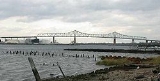
The Outerbridge Crossing is a cantilever bridge
which spans the Arthur Kill
. The "Outerbridge", as it is commonly known, connects Perth Amboy, New Jersey
, with the New York City
borough of Staten Island
and carries NY-440
and NJ-440
, each road ending at the respective state border.
The bridge was named for Eugenius Harvey Outerbridge (sometimes pronounced "ooterbridge") the first chairman of the then-Port of New York Authority and a resident of Staten Island. Rather than call it the "Outerbridge Bridge" the span was labeled a "crossing", but many New Yorkers and others mistakenly assume the name comes from the fact that it is the most remote bridge in New York City and the southernmost crossing in New York state.
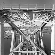 It is a steel cantilever
construction, designed by John Alexander Low Waddell
and built under the auspices of the Port of New York Authority, now the Port Authority of New York and New Jersey, which currently operates it.
It opened simultaneously with the Goethals Bridge
on June 29, 1928. Both spans have similar designs. Neither bridge saw high traffic counts until the opening of the Verrazano-Narrows Bridge
in 1964. Traffic counts on both bridges were also depressed due to the effects of the Great Depression
and World War II
.
The Outerbridge Crossing carried 32,438,000 vehicles (both directions) in 2006, or approximately 90,000 each day. Tolls are collected in the eastbound direction only. As of September 18, 2011, the cash toll
s going from New Jersey to Staten Island will be charged $12 for cars and $11 for motorcycles (there is no toll for passenger vehicles going from Staten Island to New Jersey). All E-ZPass
users will be charged $7.50 for cars and $6.50 for motorcycles during off-peak hours (outside of 6-10 am and 4-8 pm on the weekdays; and outside of 11 am - 9 pm on the weekends) and $9.50 for cars and $8.50 for motorcycles during peak hours (6-10 am and 4-8 pm on the weekdays; and 11 am - 9 pm on the weekends).
In 2003, the Port Authority raised the speed limit for the three inner E-ZPass lanes at the toll plaza from 15 mph to 25 mph, separating these lanes from the rest of the eight-lane toll plaza by a barrier. Two years later, the tollbooths adjacent to the 25 mph E-ZPass lanes were removed and overhead gantries were installed with electronic tag readers to permit E-ZPass vehicles to travel at 45 mph in special high-speed lanes. Motorists using the high-speed E-ZPass lanes cannot use the Page Avenue exit, which is located immediately after the toll plaza.
In recent years, the bridge has undergone numerous repair jobs as a result of the high volume of traffic that crosses the bridge each day.
Cantilever bridge
A cantilever bridge is a bridge built using cantilevers, structures that project horizontally into space, supported on only one end. For small footbridges, the cantilevers may be simple beams; however, large cantilever bridges designed to handle road or rail traffic use trusses built from...
which spans the Arthur Kill
Arthur Kill
The Arthur Kill is a tidal strait separating Staten Island, New York from mainland New Jersey, USA, and a major navigational channel of the Port of New York and New Jersey. Kill is from the Middle Dutch word kille, meaning "riverbed" or "water channel"...
. The "Outerbridge", as it is commonly known, connects Perth Amboy, New Jersey
Perth Amboy, New Jersey
Perth Amboy is a city in Middlesex County, New Jersey, United States. The City of Perth Amboy is part of the New York metropolitan area. As of the 2010 United States Census, the city population was 50,814. Perth Amboy is known as the "City by the Bay", referring to Raritan Bay.-Name:The Lenape...
, with the New York City
New York City
New York is the most populous city in the United States and the center of the New York Metropolitan Area, one of the most populous metropolitan areas in the world. New York exerts a significant impact upon global commerce, finance, media, art, fashion, research, technology, education, and...
borough of Staten Island
Staten Island
Staten Island is a borough of New York City, New York, United States, located in the southwest part of the city. Staten Island is separated from New Jersey by the Arthur Kill and the Kill Van Kull, and from the rest of New York by New York Bay...
and carries NY-440
New York State Route 440
New York State Route 440 is a state highway located entirely on Staten Island in New York City. The route acts as a connector between the two segments of New Jersey Route 440, running from the Staten Island community of Richmond Valley to the south to Port Richmond to the north...
and NJ-440
Route 440 (New Jersey)
Route 440 is a state highway in New Jersey, United States. It is composed of two segments, a freeway in Middlesex County linking Interstate 287 and the New Jersey Turnpike in Edison to the Outerbridge Crossing in Perth Amboy and a four-lane divided highway in Hudson County running from the...
, each road ending at the respective state border.
The bridge was named for Eugenius Harvey Outerbridge (sometimes pronounced "ooterbridge") the first chairman of the then-Port of New York Authority and a resident of Staten Island. Rather than call it the "Outerbridge Bridge" the span was labeled a "crossing", but many New Yorkers and others mistakenly assume the name comes from the fact that it is the most remote bridge in New York City and the southernmost crossing in New York state.
Cantilever
A cantilever is a beam anchored at only one end. The beam carries the load to the support where it is resisted by moment and shear stress. Cantilever construction allows for overhanging structures without external bracing. Cantilevers can also be constructed with trusses or slabs.This is in...
construction, designed by John Alexander Low Waddell
John Alexander Low Waddell
John Alexander Low Waddell was an American civil engineer and prolific bridge designer, with more than a thousand structures to his credit in the United States, Canada, as well as Mexico, Russia, China, Japan, and New Zealand...
and built under the auspices of the Port of New York Authority, now the Port Authority of New York and New Jersey, which currently operates it.
It opened simultaneously with the Goethals Bridge
Goethals Bridge
The Goethals Bridge connects Elizabeth, New Jersey to Staten Island , near the Howland Hook Marine Terminal, Staten Island, New York over the Arthur Kill. Operated by the Port Authority of New York and New Jersey, the span was one of the first structures built by the authority...
on June 29, 1928. Both spans have similar designs. Neither bridge saw high traffic counts until the opening of the Verrazano-Narrows Bridge
Verrazano-Narrows Bridge
The Verrazano-Narrows Bridge is a double-decked suspension bridge that connects the boroughs of Staten Island and Brooklyn in New York City at the Narrows, the reach connecting the relatively protected upper bay with the larger lower bay....
in 1964. Traffic counts on both bridges were also depressed due to the effects of the Great Depression
Great Depression
The Great Depression was a severe worldwide economic depression in the decade preceding World War II. The timing of the Great Depression varied across nations, but in most countries it started in about 1929 and lasted until the late 1930s or early 1940s...
and World War II
World War II
World War II, or the Second World War , was a global conflict lasting from 1939 to 1945, involving most of the world's nations—including all of the great powers—eventually forming two opposing military alliances: the Allies and the Axis...
.
The Outerbridge Crossing carried 32,438,000 vehicles (both directions) in 2006, or approximately 90,000 each day. Tolls are collected in the eastbound direction only. As of September 18, 2011, the cash toll
Toll bridge
A toll bridge is a bridge over which traffic may pass upon payment of a toll, or fee.- History :The practice of collecting tolls on bridges probably harks back to the days of ferry crossings where people paid a fee to be ferried across stretches of water. As boats became impractical to carry large...
s going from New Jersey to Staten Island will be charged $12 for cars and $11 for motorcycles (there is no toll for passenger vehicles going from Staten Island to New Jersey). All E-ZPass
E-ZPass
E-ZPass is an electronic toll-collection system used on most tolled roads, bridges, and tunnels in the northeastern US, south to Virginia and West Virginia, and west to Illinois. Currently, there are 25 agencies spread across 14 states that make up the . All member agencies use the same technology,...
users will be charged $7.50 for cars and $6.50 for motorcycles during off-peak hours (outside of 6-10 am and 4-8 pm on the weekdays; and outside of 11 am - 9 pm on the weekends) and $9.50 for cars and $8.50 for motorcycles during peak hours (6-10 am and 4-8 pm on the weekdays; and 11 am - 9 pm on the weekends).
In 2003, the Port Authority raised the speed limit for the three inner E-ZPass lanes at the toll plaza from 15 mph to 25 mph, separating these lanes from the rest of the eight-lane toll plaza by a barrier. Two years later, the tollbooths adjacent to the 25 mph E-ZPass lanes were removed and overhead gantries were installed with electronic tag readers to permit E-ZPass vehicles to travel at 45 mph in special high-speed lanes. Motorists using the high-speed E-ZPass lanes cannot use the Page Avenue exit, which is located immediately after the toll plaza.
In recent years, the bridge has undergone numerous repair jobs as a result of the high volume of traffic that crosses the bridge each day.
External links
- Port Authority: Outerbridge Crossing
- Outerbridge Crossing Historic Overview at Steve Anderson's nycroads.com