
Outer London
Encyclopedia
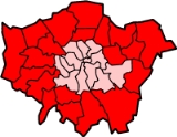
Outer London is the name for the group of London Boroughs that form a ring around Inner London
.
These were areas that were not part of the County of London
and became formally part of Greater London
in 1965. An exception is North Woolwich
, which was in the County of London but was transferred to Newham in 1965.
The outer London boroughs were defined by the London Government Act 1963
.
and the Census
define Outer London differently, excluding Haringey
and Newham
(which are defined as Inner London), and including Greenwich
. This is reflected in the Nomenclature of Territorial Units for Statistics
(NUTS) classification. Under this classification, Outer London consists of Barking and Dagenham, Barnet, Bexley, Brent, Bromley, Croydon, Ealing, Enfield, Greenwich, Harrow, Havering, Hillingdon, Hounslow, Kingston upon Thames, Merton, Redbridge, Richmond upon Thames, Sutton, and Waltham Forest.
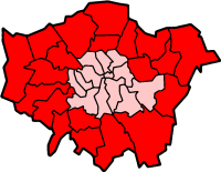
Inner London
Inner London is the name for the group of London boroughs which form the interior part of Greater London and are surrounded by Outer London. The area was first officially defined in 1965 and for purposes such as statistics, the definition has changed over time. The terms Inner London and Central...
.
These were areas that were not part of the County of London
County of London
The County of London was a county of England from 1889 to 1965, corresponding to the area known today as Inner London. It was created as part of the general introduction of elected county government in England, by way of the Local Government Act 1888. The Act created an administrative County of...
and became formally part of Greater London
Greater London
Greater London is the top-level administrative division of England covering London. It was created in 1965 and spans the City of London, including Middle Temple and Inner Temple, and the 32 London boroughs. This territory is coterminate with the London Government Office Region and the London...
in 1965. An exception is North Woolwich
North Woolwich
North Woolwich is a place in the London Borough of Newham. It is located north of Woolwich proper which is on the south bank of the River Thames. The two places are linked by the Woolwich Ferry and the Woolwich foot tunnel.-History:...
, which was in the County of London but was transferred to Newham in 1965.
London Government Act 1963
| Outer London - Primary Definition | |
 | |
| ONS Office for National Statistics The Office for National Statistics is the executive office of the UK Statistics Authority, a non-ministerial department which reports directly to the Parliament of the United Kingdom.- Overview :... 's Outer London | |
 |
The outer London boroughs were defined by the London Government Act 1963
London Government Act 1963
The London Government Act 1963 is an Act of the Parliament of the United Kingdom, which recognised officially the conurbation known as Greater London and created a new local government structure for the capital. The Act significantly reduced the number of local government districts in the area,...
.
- Barking and DagenhamLondon Borough of Barking and DagenhamIn 1801, the civil parishes that form the modern borough had a total population of 1,937; and the area was characterised by farming, woodland and the fishing fleet at Barking. This last industry employed 1,370 men and boys by 1850, but by the end of the century had ceased to exist; replaced by...
- BarnetLondon Borough of BarnetThe London Borough of Barnet is a London borough in North London and forms part of Outer London. It has a population of 331,500 and covers . It borders Hertfordshire to the north and five other London boroughs: Harrow and Brent to the west, Camden and Haringey to the south-east and Enfield to the...
- BexleyLondon Borough of BexleyThe London Borough of Bexley lies in south east Greater London, and is a borough referred to as part of Outer London. It has common borders with the London Borough of Bromley to the south, the London Borough of Greenwich to the west, across the River Thames to the north it borders the London...
- BrentLondon Borough of BrentIn 1801, the civil parishes that form the modern borough had a total population of 2,022. This rose slowly throughout the 19th century, as the district became built up; reaching 5,646 in the middle of the century. When the railways arrived the rate of population growth increased...
- BromleyLondon Borough of BromleyThe London Borough of Bromley is a London borough of south east London, England and forms part of Outer London. The principal town in the borough is Bromley.-Geography:...
- CroydonLondon Borough of CroydonThe London Borough of Croydon is a London borough in South London, England and is part of Outer London. It covers an area of and is the largest London borough by population. It is the southernmost borough of London. At its centre is the historic town of Croydon from which the borough takes its name...
- EalingLondon Borough of EalingThe London Borough of Ealing is a borough in west London.-Location:The London Borough of Ealing borders the London Borough of Hillingdon to the west, the London Borough of Harrow and the London Borough of Brent to the north, the London Borough of Hammersmith and Fulham to the east and the London...
- EnfieldLondon Borough of EnfieldThe London Borough of Enfield is the most northerly London borough and forms part of Outer London. It borders the London Boroughs of Barnet, Haringey and Waltham Forest...
- HaringeyLondon Borough of HaringeyThe London Borough of Haringey is a London borough, in North London, classified by some definitions as part of Inner London, and by others as part of Outer London. It was created in 1965 by the amalgamation of three former boroughs. It shares borders with six other London boroughs...
- HarrowLondon Borough of HarrowThe London Borough of Harrow is a London borough of north-west London. It borders Hertfordshire to the north and other London boroughs: Hillingdon to the west, Ealing to the south, Brent to the south-east and Barnet to the east.-History:...
- HaveringLondon Borough of HaveringThe London Borough of Havering is a London borough in North East London, England and forms part of Outer London. The principal town in Havering is Romford and the other main communities are Hornchurch, Upminster and Rainham. The borough is mainly characterised by suburban development with large...
- HillingdonLondon Borough of HillingdonThe London Borough of Hillingdon is the westernmost borough in Greater London, England. The borough's population was recorded as 243,006 in the 2001 Census. The borough incorporates the former districts of Ruislip-Northwood, Uxbridge, Hayes and Harlington and Yiewsley and West Drayton in the...
- HounslowLondon Borough of Hounslow-Political composition:Since the borough was formed it has been controlled by the Labour Party on all but two occasions. In 1968 the Conservatives formed a majority for the first and last time to date until they lost control to Labour in 1971. Labour subsequently lost control of the council in the...
- Kingston upon ThamesRoyal Borough of Kingston upon ThamesThe Royal Borough of Kingston upon Thames is a borough in southwest London, England. The main town is Kingston upon Thames and it includes Surbiton, Chessington, New Malden and Tolworth. It is the oldest of the three Royal Boroughs in England, the others are Kensington and Chelsea, also in London,...
- MertonLondon Borough of MertonThe London Borough of Merton is a borough in southwest London, England.The borough was formed under the London Government Act in 1965 by the merger of the Municipal Borough of Mitcham, the Municipal Borough of Wimbledon and the Merton and Morden Urban District, all formerly within Surrey...
- NewhamLondon Borough of NewhamThe London Borough of Newham is a London borough formed from the towns of West Ham and East Ham, within East London.It is situated east of the City of London, and is north of the River Thames. According to 2006 estimates, Newham has one of the highest ethnic minority populations of all the...
- RedbridgeLondon Borough of RedbridgeThe London Borough of Redbridge is a London borough in outer north-east London. Its administrative headquarters is at Redbridge Town Hall in Ilford. The local authority is Redbridge London Borough Council.-Etymology:...
- Richmond upon ThamesLondon Borough of Richmond upon ThamesThe London Borough of Richmond upon Thames is a London borough in South West London, UK, which forms part of Outer London. It is unique because it is the only London borough situated both north and south of the River Thames.-Settlement:...
- SuttonLondon Borough of SuttonThe London Borough of Sutton is a London borough in South London, England and forms part of Outer London. It covers an area of and is the 80th largest local authority in England by population. It is one of the southernmost boroughs of London...
- Waltham ForestLondon Borough of Waltham ForestThe London Borough of Waltham Forest is in northeast London, England. Officially, it forms part of Outer London as it borders Essex. However, it can be seen that the NE London boundary does not extend far compared to elsewhere in the city...
ONS definition (statistics)
The Office for National StatisticsOffice for National Statistics
The Office for National Statistics is the executive office of the UK Statistics Authority, a non-ministerial department which reports directly to the Parliament of the United Kingdom.- Overview :...
and the Census
Census
A census is the procedure of systematically acquiring and recording information about the members of a given population. It is a regularly occurring and official count of a particular population. The term is used mostly in connection with national population and housing censuses; other common...
define Outer London differently, excluding Haringey
London Borough of Haringey
The London Borough of Haringey is a London borough, in North London, classified by some definitions as part of Inner London, and by others as part of Outer London. It was created in 1965 by the amalgamation of three former boroughs. It shares borders with six other London boroughs...
and Newham
London Borough of Newham
The London Borough of Newham is a London borough formed from the towns of West Ham and East Ham, within East London.It is situated east of the City of London, and is north of the River Thames. According to 2006 estimates, Newham has one of the highest ethnic minority populations of all the...
(which are defined as Inner London), and including Greenwich
London Borough of Greenwich
The London Borough of Greenwich is an Inner London borough in south-east London, England. Taking its name from the historic town of Greenwich, the present borough was formed in 1965 by the amalgamation of the former area of the Metropolitan Borough of Greenwich with part of the Metropolitan...
. This is reflected in the Nomenclature of Territorial Units for Statistics
NUTS:UK
In the NUTS codes of the United Kingdom , the three levels are:-NUTS codes:...
(NUTS) classification. Under this classification, Outer London consists of Barking and Dagenham, Barnet, Bexley, Brent, Bromley, Croydon, Ealing, Enfield, Greenwich, Harrow, Havering, Hillingdon, Hounslow, Kingston upon Thames, Merton, Redbridge, Richmond upon Thames, Sutton, and Waltham Forest.
Historical population
Please note: Figures here are for the Office for National Statistics defined Outer London (in its 2001 limits), whose land area is 1,254 km2 (484 sq. miles). Figures before 1971 have been reconstructed by the Office for National Statistics based on past censuses in order to fit the 2001 limits. Figures from 1981 onward are midyear estimates, with those for 2002 to 2009 having been revised during 2010. These mid-year estimates are more accurate than the censuses themselves, which are known to underestimate the population of London.| Date | Population |
|---|---|
| 1891, April 5/6 | 1,083,770 |
| 1901, March 31/April 1 | 1,647,396 |
| 1911, April 2/3 | 2,162,288 |
| 1921, June 19/20 | 2,413,978 |
| 1931, April 26/27 | 3,217,219 |
| 1939, Mid-year estimate | 4,250,788 |
| 1951, April 8/9 | 4,517,588 |
| 1961, April 23/24 | 4,499,737 |
| 1971, April 25/26 | 4,420,585 |
| 1981, Midyear estimate | 4,254,900 |
| 1991, Midyear estimate | 4,230,000 |
| 2001, Midyear estimate | 4,463,100 |
| 2002, Midyear estimate | 4,480,300 |
| 2003, Midyear estimate | 4,485,000 |
| 2004, Midyear estimate | 4,501,200 |
| 2005, Midyear estimate | 4,537,000 |
| 2006, Midyear estimate | 4,570,700 |
| 2007, Midyear estimate | 4,598,800 |
| 2008, Midyear estimate | 4,638,400 |
| 2009, Midyear estimate | 4,692,200 |