Outagamie County, Wisconsin
Encyclopedia
Outagamie is a county
County (United States)
In the United States, a county is a geographic subdivision of a state , usually assigned some governmental authority. The term "county" is used in 48 of the 50 states; Louisiana is divided into parishes and Alaska into boroughs. Parishes and boroughs are called "county-equivalents" by the U.S...

 in the northeast region of the U.S. state
U.S. state
A U.S. state is any one of the 50 federated states of the United States of America that share sovereignty with the federal government. Because of this shared sovereignty, an American is a citizen both of the federal entity and of his or her state of domicile. Four states use the official title of...

 of Wisconsin
Wisconsin
Wisconsin is a U.S. state located in the north-central United States and is part of the Midwest. It is bordered by Minnesota to the west, Iowa to the southwest, Illinois to the south, Lake Michigan to the east, Michigan to the northeast, and Lake Superior to the north. Wisconsin's capital is...

. Its county seat
County seat
A county seat is an administrative center, or seat of government, for a county or civil parish. The term is primarily used in the United States....

 is Appleton
Appleton, Wisconsin
Appleton is a city in Outagamie, Calumet, and Winnebago Counties in the U.S. state of Wisconsin. It is situated on the Fox River, 30 miles southwest of Green Bay and 100 miles north of Milwaukee. Appleton is the county seat of Outagamie County. The population was 78,086 at the 2010 census...

. As of the 2009 census estimate, its population was 177,155.

Outagamie County, along with neighboring Calumet County
Calumet County, Wisconsin
Calumet County is a county located in the U.S. state of Wisconsin. It is included in the Appleton, Wisconsin, Metropolitan Statistical Area. As of 2010, the county's population was 48,971. The county seat is Chilton.-History:...

, forms the Appleton, Wisconsin
Appleton, Wisconsin
Appleton is a city in Outagamie, Calumet, and Winnebago Counties in the U.S. state of Wisconsin. It is situated on the Fox River, 30 miles southwest of Green Bay and 100 miles north of Milwaukee. Appleton is the county seat of Outagamie County. The population was 78,086 at the 2010 census...

, Metropolitan Statistical Area. Outagamie County is also part of the Appleton-Neenah-Oshkosh Combined Statistical Area, along with adjacent Winnebago County
Winnebago County, Wisconsin
Winnebago County is a county in the U.S. state of Wisconsin. As of 2009, the population estimate was 163,370. Its county seat is Oshkosh. Winnebago County is included in the Oshkosh, Wisconsin-Neenah, Wisconsin, Metropolitan Statistical Area.-Geography:...

.

History

"Outagamie," an Anishinaabe
Anishinaabe
Anishinaabe or Anishinabe—or more properly Anishinaabeg or Anishinabek, which is the plural form of the word—is the autonym often used by the Odawa, Ojibwe, and Algonquin peoples. They all speak closely related Anishinaabemowin/Anishinaabe languages, of the Algonquian language family.The meaning...

 term for the Meskwaki
Meskwaki
The Meskwaki are a Native American people often known to outsiders as the Fox tribe. They have often been closely linked to the Sauk people. In their own language, the Meskwaki call themselves Meshkwahkihaki, which means "the Red-Earths." Historically their homelands were in the Great Lakes region...

 (Fox) Indians, translates to "dwellers of other shore" or "dwellers on the other side of the stream."

Geography

According to the U.S. Census Bureau
United States Census Bureau
The United States Census Bureau is the government agency that is responsible for the United States Census. It also gathers other national demographic and economic data...

, the county has a total area of 644 square miles (1,668 km²), of which 640 square miles (1,658 km²) is land and 4 square miles (10.4 km²) is water.

Major highways

  • U.S. Highway 41
  • U.S. Highway 45
  • Wisconsin Highway 15
  • Wisconsin Highway 29
  • Wisconsin Highway 32
  • Wisconsin Highway 47
  • Wisconsin Highway 54
  • Wisconsin Highway 55
  • Wisconsin Highway 76
  • Wisconsin Highway 96
  • Wisconsin Highway 125
  • Wisconsin Highway 187
  • Wisconsin Highway 441

  • Demographics


    As of the census
    Census
    A census is the procedure of systematically acquiring and recording information about the members of a given population. It is a regularly occurring and official count of a particular population. The term is used mostly in connection with national population and housing censuses; other common...

    of 2000, there were 160,971 people, 60,530 households, and 42,189 families residing in the county. The population density
    Population density
    Population density is a measurement of population per unit area or unit volume. It is frequently applied to living organisms, and particularly to humans...

     was 251 /sqmi. There were 62,614 housing units at an average density of 98 /sqmi. The racial makeup of the county was 93.87% White
    Race (United States Census)
    Race and ethnicity in the United States Census, as defined by the Federal Office of Management and Budget and the United States Census Bureau, are self-identification data items in which residents choose the race or races with which they most closely identify, and indicate whether or not they are...

    , 0.54% Black
    Race (United States Census)
    Race and ethnicity in the United States Census, as defined by the Federal Office of Management and Budget and the United States Census Bureau, are self-identification data items in which residents choose the race or races with which they most closely identify, and indicate whether or not they are...

     or African American
    Race (United States Census)
    Race and ethnicity in the United States Census, as defined by the Federal Office of Management and Budget and the United States Census Bureau, are self-identification data items in which residents choose the race or races with which they most closely identify, and indicate whether or not they are...

    , 1.54% Native American
    Race (United States Census)
    Race and ethnicity in the United States Census, as defined by the Federal Office of Management and Budget and the United States Census Bureau, are self-identification data items in which residents choose the race or races with which they most closely identify, and indicate whether or not they are...

    , 2.23% Asian
    Race (United States Census)
    Race and ethnicity in the United States Census, as defined by the Federal Office of Management and Budget and the United States Census Bureau, are self-identification data items in which residents choose the race or races with which they most closely identify, and indicate whether or not they are...

    , 0.03% Pacific Islander
    Race (United States Census)
    Race and ethnicity in the United States Census, as defined by the Federal Office of Management and Budget and the United States Census Bureau, are self-identification data items in which residents choose the race or races with which they most closely identify, and indicate whether or not they are...

    , 0.81% from other races
    Race (United States Census)
    Race and ethnicity in the United States Census, as defined by the Federal Office of Management and Budget and the United States Census Bureau, are self-identification data items in which residents choose the race or races with which they most closely identify, and indicate whether or not they are...

    , and 0.98% from two or more races. 1.99% of the population were Hispanic
    Race (United States Census)
    Race and ethnicity in the United States Census, as defined by the Federal Office of Management and Budget and the United States Census Bureau, are self-identification data items in which residents choose the race or races with which they most closely identify, and indicate whether or not they are...

     or Latino
    Race (United States Census)
    Race and ethnicity in the United States Census, as defined by the Federal Office of Management and Budget and the United States Census Bureau, are self-identification data items in which residents choose the race or races with which they most closely identify, and indicate whether or not they are...

     of any race. 47.7% were of German, 9.4% Dutch
    Dutch people
    The Dutch people are an ethnic group native to the Netherlands. They share a common culture and speak the Dutch language. Dutch people and their descendants are found in migrant communities worldwide, notably in Suriname, Chile, Brazil, Canada, Australia, South Africa, New Zealand, and the United...

    , 6.2% Irish
    Irish people
    The Irish people are an ethnic group who originate in Ireland, an island in northwestern Europe. Ireland has been populated for around 9,000 years , with the Irish people's earliest ancestors recorded having legends of being descended from groups such as the Nemedians, Fomorians, Fir Bolg, Tuatha...

     and 5.2% American
    United States
    The United States of America is a federal constitutional republic comprising fifty states and a federal district...

     ancestry according to Census 2000.

    Of the 60,530 households, 36.00% had children under the age of 18 living with them, 58.90% were married couples
    Marriage
    Marriage is a social union or legal contract between people that creates kinship. It is an institution in which interpersonal relationships, usually intimate and sexual, are acknowledged in a variety of ways, depending on the culture or subculture in which it is found...

     living together, 7.60% had a female householder with no husband present, and 30.30% were non-families. 24.20% of all households were made up of individuals and 8.40% had someone living alone who was 65 years of age or older. The average household size was 2.61 and the average family size was 3.14.

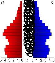
    By age, 27.70% of the population was under 18, 8.90% from 18 to 24, 31.90% from 25 to 44, 20.70% from 45 to 64, and 10.90% were 65 or older. The median age was 34 years. For every 100 females there were 99.50 males. For every 100 females age 18 and over, there were 96.90 males.

    Cities, Villages, and Towns


    Cities
    • Appleton
      Appleton, Wisconsin
      Appleton is a city in Outagamie, Calumet, and Winnebago Counties in the U.S. state of Wisconsin. It is situated on the Fox River, 30 miles southwest of Green Bay and 100 miles north of Milwaukee. Appleton is the county seat of Outagamie County. The population was 78,086 at the 2010 census...

       - County Seat
    • Kaukauna
      Kaukauna, Wisconsin
      Kaukauna is a city in Outagamie County, Wisconsin, United States, on the Fox River, approximately 100 miles north of Milwaukee, with a population of 12,983. It is a part of the Appleton, Wisconsin Metropolitan Statistical Area, which is included in the Appleton-Oshkosh-Neenah, Wisconsin Combined...

    • New London
      New London, Wisconsin
      New London is a city in Outagamie and Waupaca Counties in the U.S. state of Wisconsin. The population was 7,295 at the 2010 census. The city has a Saint Patrick's Day Parade, Irish Fest, and week-long festivities, when the city's name is changed to "New Dublin" for the week. The American Water...

    • Seymour
      Seymour, Wisconsin
      Seymour is a city in Outagamie County, Wisconsin, United States. The population was 3,451 at the 2010 census. The city is located within the Town of Seymour and the Town of Osborn.-History:...


    Villages
    • Bear Creek
      Bear Creek, Outagamie County, Wisconsin
      Bear Creek is a village in Outagamie County, Wisconsin, United States. The population was 448 at the 2010 census.-History:From 1898 to 1915, Bear Creek was called Welcome...

    • Black Creek
      Black Creek, Wisconsin
      -Demographics:As of the census of 2010, there were 1,316 people, 540 households, and 513 families residing in the village. The population density was 1,097.6 people per square mile . There were 540 housing units at an average density of 450 per square mile...

    • Combined Locks
      Combined Locks, Wisconsin
      Combined Locks is a village in Outagamie County, Wisconsin, United States. The population was 2,422 at the 2000 census.-Geography:Combined Locks is located at ....

    • Hortonville
      Hortonville, Wisconsin
      Hortonville is a village in Outagamie County, Wisconsin, United States. The population was 2,711 at the 2010 census.-History:The village was founded in 1848 by landowner Alonzo Horton. One of Father Horton's first priorities was to dam Black Otter Creek, creating the Black Otter Lake...

    • Howard
      Howard, Wisconsin
      Howard is a village in Brown and Outagamie counties in the U.S. state of Wisconsin. The population was 17,399 at the 2010 census. It is part of the Green Bay Metropolitan Statistical Area....

    • Kimberly
      Kimberly, Wisconsin
      Kimberly is a village in Outagamie County, Wisconsin, United States. The population was 6,146 at the 2000 census.-History:Kimberly was founded in 1889 and was named after John A...

    • Little Chute
      Little Chute, Wisconsin
      Little Chute is a village in Outagamie County, Wisconsin, United States. The population was 10,476 at the 2000 census.-Geography:Little Chute is located at ....

    • Nichols
      Nichols, Wisconsin
      Nichols is a village in Outagamie County, Wisconsin, United States. The population was 273 at the 2010 census.-Geography:Nichols is located at ....

    • Shiocton
      Shiocton, Wisconsin
      Shiocton is a village in Outagamie County, Wisconsin, United States. The population was 921 at the 2010 census.-Geography:Shiocton is located at ....

    • Wrightstown
      Wrightstown, Wisconsin
      Wrightstown is a village in Brown and Outagamie Counties in the U.S. state of Wisconsin. The population was 2,827 at the 2010 census. The village is located mostly within the town of Wrightstown in Brown County...


    Ghost Towns
    • Grand Chute
      Grand Chute (Ghost Town), Wisconsin
      Grand Chute is a ghost town in Outagamie County, Wisconsin, United States. It was located in the town of Grand Chute. The location of Grand Chute is now occupied by the City of Appleton. There are surviving buildings from this ghost town; they are protected and are listed on the National Register...

    • Lawesburg
      Lawesburg, Wisconsin
      Lawesburg is a ghost town in Outagamie County, Wisconsin, United States. It was located in the town of Grand Chute. The location of Lawesburg is now occupied by the City of Appleton. There are surviving buildings from this ghost town; they are protected and are listed on the National Register of...

    • Lime Rock
      Lime Rock, Wisconsin
      Lime Rock is a ghost town in Outagamie County, Wisconsin, United States. It was located in the town of Seymour and the town of Osborn. The ghost town has no surviving buildings and has been forgotten.-Geography:...

    • Wakefield
      Wakefield, Wisconsin
      Wakefield is a ghost town in Outagamie County, Wisconsin, United States. It was located in the town of Greenville. The ghost town has no surviving buildings and has been forgotten.-Geography:...


    Towns
    • Black Creek (town)
      Black Creek (town), Wisconsin
      -Transportation:-Recreation:****Town Hall Park-External links:* * * * * -References:...

    • Bovina
      Bovina, Wisconsin
      Bovina is a town in Outagamie County, Wisconsin, United States. As of the 2000 census, the town had a total population of 1,130. The village of Shiocton is located within the town.-Geography:...

    • Buchanan
      Buchanan, Wisconsin
      Buchanan is a town in Outagamie County, Wisconsin, United States. The population was 5,827 at the 2000 census. The urbanized portions of the towns of Harrison and Buchanan are collectively known locally as Darboy.-Geography:...

    • Center
      Center, Outagamie County, Wisconsin
      Center is a town in Outagamie County, Wisconsin, United States. The population was 3,163 at the 2000 census. The unincorporated communities of Mackville and Five Corners are located partially within the town...

    • Cicero
      Cicero, Wisconsin
      Cicero is a town in Outagamie County, Wisconsin, United States. The population was 1,092 at the 2000 census. The unincorporated community of Cicero is located in the town.-Geography:...

    • Dale
      Dale, Wisconsin
      Dale is a town in Outagamie County, Wisconsin, United States. The population was 2,731 at the 2010 census. The census-designated place of Dale and the unincorporated community of Medina are located in the town.-History:...

    • Deer Creek
      Deer Creek, Outagamie County, Wisconsin
      Deer Creek is a town in Outagamie County, Wisconsin, United States. The population was 682 at the 2000 census.-Geography:According to the United States Census Bureau, the town has a total area of 35.5 square miles , of which, 35.5 square miles of it is land and 0.04 square miles of...

    • Ellington
      Ellington, Wisconsin
      Ellington is a town in Outagamie County, Wisconsin, United States. The population was 2,535 at the 2000 census. The unincorporated community of Stephensville is located in the town.-Geography:...

    • Freedom
      Freedom, Outagamie County, Wisconsin
      Freedom is a town in Outagamie County, Wisconsin, United States. The population was 5,842 at the 2010 census. The unincorporated communities of Freedom, and Murphy Corner are located in the town...

    • Grand Chute
      Grand Chute, Wisconsin
      Grand Chute is a town in Outagamie County, Wisconsin, United States. The city of Appleton and unincorporated community of Apple Creek are partially located in the town...

    • Greenville (town)
      Greenville, Wisconsin
      Greenville is a town located in south central Outagamie County, Wisconsin, United States. It is one of 18 communities that form the basis of the Fox Cities, the third largest metropolitan area in Wisconsin. The population was 6,844 at the 2000 census, however 2008 estimates place the population at...

    • Hortonia
      Hortonia, Wisconsin
      Hortonia is a town in Outagamie County, Wisconsin, United States. The population was 1,063 at the 2000 census.-Geography:According to the United States Census Bureau, the town has a total area of 19.4 square miles , of which, 19.2 square miles of it is land and 0.2 square miles of...

    • Kaukauna (town)
      Kaukauna (town), Wisconsin
      Kaukauna is a town in Outagamie County, Wisconsin, United States. The population was 1,238 at the 2010 census.-History:In 1885, the adjacent City of Kaukauna was removed from the town when it incorporated...

    • Liberty
      Liberty, Outagamie County, Wisconsin
      There are three other towns called 'Liberty' in Wisconsin, see Liberty, WisconsinLiberty is a town in Outagamie County, Wisconsin, United States...

    • Maine
      Maine, Outagamie County, Wisconsin
      Maine is a town in Outagamie County, Wisconsin, United States. The population was 831 at the 2000 census. The unincorporated community of Leeman is located in the town.-Geography:...

    • Maple Creek
      Maple Creek, Wisconsin
      Maple Creek is a town in Outagamie County, Wisconsin, United States. The population was 687 at the 2000 census. The unincorporated community of Sugar Bush is located in the town.-Geography:...

    • Oneida (town)
      Oneida (town), Wisconsin
      Oneida is a town in Outagamie County, Wisconsin, United States. The population was 4,001 at the 2000 census. The census-designated place of Oneida is located mostly within the town...

    • Osborn
      Osborn, Wisconsin
      Osborn is a town in Outagamie County, Wisconsin, United States. The unincorporated community of Five Corners is partially located in the town. The ghost town of Lime Rock was also located partially in the town.-Geography:...

    • Seymour (town)
      Seymour, Outagamie County, Wisconsin
      Seymour is a town in Outagamie County, Wisconsin, United States. The population was 1,216 at the 2000 census. The City of Seymour is located within the town. The unincorporated community of Isaar, Wisconsin is also located in the town...

    • Vandenbroek
      Vandenbroek, Wisconsin
      Vandenbroek is a town in Outagamie County, Wisconsin, United States. The population was 1,474 at the 2010 census.-Geography:According to the United States Census Bureau, the town has a total area of 9.5 square miles , all of it land....


    Unincorporated Communities
    • Apple Creek
      Apple Creek, Wisconsin
      Apple Creek is an unincorporated community located in Outagamie County, Wisconsin, United States. The community is located in the town of Grand Chute and the town of Freedom...

    • Binghamton
      Binghamton, Wisconsin
      Binghamton is an unincorporated community in Outagamie County, Wisconsin, United States. The unincorporated community is located in the Town of Black Creek.-Geography:...

    • Center Valley
      Center Valley, Wisconsin
      Center Valley is a small unincorporated farming community in the town of Center in Outagamie County, Wisconsin, United States. Center Valley is classified as a Class U6 Community by the USGS, being a populated place located wholly or substantially outside the boundaries of any incorporated place or...

    • Chicago Corners
      Chicago Corners, Outagamie County, Wisconsin
      Chicago Corners is an unincorporated community in Outagamie County, Wisconsin, United States. The unincorporated community is located in the Town of Oneida and is also located in the Oneida Nation of Wisconsin.-Geography:...

    • Cicero
      Cicero (community), Wisconsin
      Cicero is an unincorporated community located in the town of Cicero, Outagamie County, Wisconsin, United States....

    • Dale
      Dale (community), Wisconsin
      Dale is an unincorporated census-designated place in the town of Dale in Outagamie County, Wisconsin, United States. It is located at the intersection of Wisconsin Highway 96 and County T. As of the 2010 census, its population was 528....

    • Darboy
      Darboy, Wisconsin
      Darboy is an unincorporated community in Calumet and Outagamie Counties in the Fox Cities area of the U.S. state of Wisconsin. Located in the towns of Harrison and Buchanan, Darboy extends from Manitowoc Road on the south, CE on the north, State Park Road on the east, and Highway 441 on the west...

    • Five Corners
      Five Corners, Outagamie County, Wisconsin
      Five Corners is an unincorporated community in Outagamie County, Wisconsin, United States. Five Corners is located in the towns of Black Creek, Center, Osborn, and Freedom.-Geography:...

    • Freedom
      Freedom (community), Outagamie County, Wisconsin
      Freedom is an unincorporated community located in the town of Freedom, Outagamie County, Wisconsin, United States. Freedom is located along Wisconsin Highway 55 north of Kaukauna. Freedom has a post office, located in Kaukauna, which uses ZIP code 54131....

    • Greenville
      Greenville (community), Wisconsin
      Greenville is an unincorporated community located in the Town of Greenville, in Outagamie County, Wisconsin. Greenville is located at the intersection of Wisconsin Highway 76 and Wisconsin Highway 15.-References:...

    • Hamples Corner
      Hamples Corner, Outagamie County, Wisconsin
      Hamples Corner is an unincorporated community in Outagamie County, Wisconsin, United States. Hamples Corner is located in the town of Center.-Geography:Hamples Corner is located at . Its elevation is 793 feet .-Transportation:...

    • Isaar
      Isaar, Wisconsin
      Isaar is a small unincorporated community in the Town of Seymour in Outagamie County, United States, about 10 miles from Green Bay. Isaar has the same zip code as Seymour and its schools are part of the Seymour Community School District....

    • Leeman
      Leeman, Wisconsin
      Leeman is a small unincorporated community located in the Town of Maine in northwestern Outagamie County, Wisconsin, United States. It is two miles west of Nichols and one mile south of Shawano County. The Wolf River runs through the community...

    • Mackville
      Mackville, Wisconsin
      Mackville is a small unincorporated community in Outagamie County, Wisconsin, United States, three miles north of Appleton. It is located in the town of Center...

    • Medina
      Medina, Outagamie County, Wisconsin
      Medina is a small unincorporated community located entirely within the town of Dale in southwest Outagamie County, Wisconsin, United States. Medina is classified as a Class U6 Community by the USGS, being a populated place located wholly or substantially outside the boundaries of any incorporated...

    • Murphy Corner
      Murphy Corner, Outagamie County, Wisconsin
      Murphy Corner is an unincorporated community in Outagamie County, Wisconsin, United States. Murphy Corner is located in the town of Freedom.-Geography:Murphy Corner is located at . Its elevation is 811 feet .-Transportation:...

    • Oneida
      Oneida, Wisconsin
      Oneida is an unincorporated community and former census-designated place in the town of Oneida, Outagamie County, Wisconsin, United States. The population was 1,070 at the 2000 census. At the census, part of the CDP lay within the town of Hobart, which has since incorporated as a village, in...

    • Stephensville
      Stephensville, Wisconsin
      Stephensville is a small unincorporated community located entirely within the town of Ellington in west-central Outagamie County, Wisconsin, United States...

    • Sugar Bush
    • Twelve Corners


    Native American Communities
    • Oneida Nation of Wisconsin
      Oneida Nation of Wisconsin
      The Oneida Nation of Wisconsin is an Indian reservation of the Oneida tribe on the west side of the Green Bay metropolitan area.-Demography and population:The reservation comprises portions of eastern Outagamie County and western Brown County...


    Adjacent counties

    • Shawano County
      Shawano County, Wisconsin
      Shawano County is a county located in the U.S. state of Wisconsin. As of 2000, the population was 40,664. Its county seat is Shawano.-History:...

       - north
    • Brown County - east
    • Calumet County
      Calumet County, Wisconsin
      Calumet County is a county located in the U.S. state of Wisconsin. It is included in the Appleton, Wisconsin, Metropolitan Statistical Area. As of 2010, the county's population was 48,971. The county seat is Chilton.-History:...

       - southeast
    • Winnebago County
      Winnebago County, Wisconsin
      Winnebago County is a county in the U.S. state of Wisconsin. As of 2009, the population estimate was 163,370. Its county seat is Oshkosh. Winnebago County is included in the Oshkosh, Wisconsin-Neenah, Wisconsin, Metropolitan Statistical Area.-Geography:...

       - southwest
    • Waupaca County
      Waupaca County, Wisconsin
      -Demographics: As of the census of 2000, there were 51,731 people, 19,863 households, and 13,884 families residing in the county. The population density was . There were 22,508 housing units at an average density of...

      - west

    External links

    The source of this article is wikipedia, the free encyclopedia.  The text of this article is licensed under the GFDL.
     
    x
    OK