
Ouistreham
Encyclopedia
Ouistreham is a commune
in the Calvados
department' in the Basse-Normandie
region
in northwestern France
.
Ouistreham is a small port
with fishing boats, leisure craft and a ferry-harbour. It serves as the port of the city of Caen
. The town is about the mouth of the Canal de Caen à la Mer
.
Since the beginning of the 20th century, it is a bathing beach on the "Riva Bella".
On 6 June 1944, No. 4 Commando
landed at Ouistreham (Sword Beach
) and fought their way to Pegasus Bridge
, with the 177 Free French of the No. 10 (Inter-Allied) Commando
given the honour of spearheading the advance. The assault on Ouistreham was featured in the movie The Longest Day
, although the film location for Ouistreham was actually at Port-en-Bessin.

ferry
service to Portsmouth
, operated by Brittany Ferries
.
village of Angmering
in England; also with Braine-l'Alleud
in Belgium, and Lohr am Main in Germany.
Communes of France
The commune is the lowest level of administrative division in the French Republic. French communes are roughly equivalent to incorporated municipalities or villages in the United States or Gemeinden in Germany...
in the Calvados
Calvados
The French department of Calvados is part of the region of Basse-Normandie in Normandy. It takes its name from a cluster of rocks off the English Channel coast...
department' in the Basse-Normandie
Basse-Normandie
Lower Normandy is an administrative region of France. It was created in 1956, when the Normandy region was divided into Lower Normandy and Upper Normandy...
region
Régions of France
France is divided into 27 administrative regions , 22 of which are in Metropolitan France, and five of which are overseas. Corsica is a territorial collectivity , but is considered a region in mainstream usage, and is even shown as such on the INSEE website...
in northwestern France
France
The French Republic , The French Republic , The French Republic , (commonly known as France , is a unitary semi-presidential republic in Western Europe with several overseas territories and islands located on other continents and in the Indian, Pacific, and Atlantic oceans. Metropolitan France...
.
Ouistreham is a small port
Port
A port is a location on a coast or shore containing one or more harbors where ships can dock and transfer people or cargo to or from land....
with fishing boats, leisure craft and a ferry-harbour. It serves as the port of the city of Caen
Caen
Caen is a commune in northwestern France. It is the prefecture of the Calvados department and the capital of the Basse-Normandie region. It is located inland from the English Channel....
. The town is about the mouth of the Canal de Caen à la Mer
Canal de Caen à la Mer
Canal de Caen à la Mer also called the "Caen Canal") is a short canal in the department of Calvados, France, connecting the Port of Caen, in the city of Caen, downstream to the town of Ouistreham and the English Channel....
.
History
The name Ouistreham derives from ouistre - 'oyster' and Saxon ham= 'village'. It has been a trading port since the Middle Ages. The harbour is now a part of "Port de Caen-Ouistreham". Ouistreham is pronounced Wee-ss-tram.Since the beginning of the 20th century, it is a bathing beach on the "Riva Bella".
On 6 June 1944, No. 4 Commando
No. 4 Commando
No. 4 Commando was a battalion-sized British Army commando unit, formed in 1940 early in the Second World War. Although it was raised to conduct small-scale raids and harass garrisons along the coast of German-occupied France, it was mainly employed as a highly-trained infantry assault unit.The...
landed at Ouistreham (Sword Beach
Sword Beach
Sword, commonly known as Sword Beach, was the code name given to one of the five main landing areas along the Normandy coast during the initial assault phase, Operation Neptune, of Operation Overlord; the Allied invasion of German-occupied France that commenced on 6 June 1944...
) and fought their way to Pegasus Bridge
Pegasus Bridge
Pegasus Bridge is a bascule bridge , built in 1934, that crossed the Caen Canal, between Caen and Ouistreham, in Normandy, France....
, with the 177 Free French of the No. 10 (Inter-Allied) Commando
No. 10 (Inter-Allied) Commando
No. 10 Commando was a commando unit of the British Army during the Second World War. The first No. 10 Commando was proposed in August 1940, using volunteers from Northern Command, however there was such a poor response that No...
given the honour of spearheading the advance. The assault on Ouistreham was featured in the movie The Longest Day
The Longest Day (film)
The Longest Day is a 1962 war film based on the 1959 history book The Longest Day by Cornelius Ryan, about "D-Day", the Normandy landings on 6 June 1944, during World War II....
, although the film location for Ouistreham was actually at Port-en-Bessin.
Population
Tourist sites
- Museum of the Atlantic Wall
- Musée du Débarquement n° 4 Commando (museum)
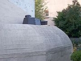
- Der Grosse Bunker is an old German bunker from WW2 that was captured by the British in the D-Day invasion
Transportation
The port of Ouistreham has a scheduled cross-ChannelEnglish Channel
The English Channel , often referred to simply as the Channel, is an arm of the Atlantic Ocean that separates southern England from northern France, and joins the North Sea to the Atlantic. It is about long and varies in width from at its widest to in the Strait of Dover...
ferry
Ferry
A ferry is a form of transportation, usually a boat, but sometimes a ship, used to carry primarily passengers, and sometimes vehicles and cargo as well, across a body of water. Most ferries operate on regular, frequent, return services...
service to Portsmouth
Portsmouth
Portsmouth is the second largest city in the ceremonial county of Hampshire on the south coast of England. Portsmouth is notable for being the United Kingdom's only island city; it is located mainly on Portsea Island...
, operated by Brittany Ferries
Brittany Ferries
Brittany Ferries is a French ferry company that runs ships between France, the UK, Ireland and Spain.-1970s and 1980s:Following the provision of the deep-water port at Roscoff, the company commenced in January 1973 at the instigation of Alexis Gourvennec, when existing ferry companies showed...
.
Twin towns
Ouistreham is twinned with the West SussexWest Sussex
West Sussex is a county in the south of England, bordering onto East Sussex , Hampshire and Surrey. The county of Sussex has been divided into East and West since the 12th century, and obtained separate county councils in 1888, but it remained a single ceremonial county until 1974 and the coming...
village of Angmering
Angmering
Angmering is a large village and civil parish between Littlehampton and Worthing in West Sussex, England. It is located approximately two miles north of the English Channel; Worthing and Littlehampton are about four miles to the east and west respectively.Angmering railway station is miles away...
in England; also with Braine-l'Alleud
Braine-l'Alleud
Braine-l'Alleud is a Walloon municipality located in the Belgian province of Walloon Brabant, about 20 kilometers south of Brussels. The Braine-l'Alleud municipality includes the former municipalities of Braine-l'Alleud proper, Ophain-Bois-Seigneur-Isaac, and Lillois-Witterzée. It also includes...
in Belgium, and Lohr am Main in Germany.