

Ouimet Canyon
Encyclopedia
Canyon
A canyon or gorge is a deep ravine between cliffs often carved from the landscape by a river. Rivers have a natural tendency to reach a baseline elevation, which is the same elevation as the body of water it will eventually drain into. This forms a canyon. Most canyons were formed by a process of...
in the Canadian
Canada
Canada is a North American country consisting of ten provinces and three territories. Located in the northern part of the continent, it extends from the Atlantic Ocean in the east to the Pacific Ocean in the west, and northward into the Arctic Ocean...
province of Ontario
Ontario
Ontario is a province of Canada, located in east-central Canada. It is Canada's most populous province and second largest in total area. It is home to the nation's most populous city, Toronto, and the nation's capital, Ottawa....
, about 60 kilometres (37.3 mi) northeast of Thunder Bay
Thunder Bay
-In Canada:Thunder Bay is the name of three places in the province of Ontario, Canada along Lake Superior:*Thunder Bay District, Ontario, a district in Northwestern Ontario*Thunder Bay, a city in Thunder Bay District*Thunder Bay, Unorganized, Ontario...
in Dorion Township
Dorion, Ontario
Dorion is a township in the Canadian province of Ontario, located within the Thunder Bay District. The township had a population of 379 in the Canada 2006 Census. Ouimet Canyon and the Dorion Bible Camp are located in the community.-Demographics:...
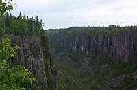
. The gorge is 100 metres (328.1 ft) deep, 150 metres (492.1 ft) wide and 2 kilometres (1.2 mi) in length, protected in the Ouimet Canyon Provincial Park.
There is a walkway consisting of boardwalk
Boardwalk
A boardwalk, in the conventional sense, is a wooden walkway for pedestrians and sometimes vehicles, often found along beaches, but they are also common as paths through wetlands, coastal dunes, and other sensitive environments....
s and trail
Trail
A trail is a path with a rough beaten or dirt/stone surface used for travel. Trails may be for use only by walkers and in some places are the main access route to remote settlements...
s, which leads to viewing platforms overlooking the canyon. Visitors to the canyon should remain on the marked trails for their own safety. Also in the Ouimet Canyon area, there are rare alpine flowers that are considered especially beautiful and arctic plants normally found 1000 km further north.
The canyon was named after a former railway station, Ouimet Station, which used to be located nearby on the Canadian Pacific Railway
Canadian Pacific Railway
The Canadian Pacific Railway , formerly also known as CP Rail between 1968 and 1996, is a historic Canadian Class I railway founded in 1881 and now operated by Canadian Pacific Railway Limited, which began operations as legal owner in a corporate restructuring in 2001...
line. The station itself was named after the Canadian Minister of Public Works
Minister of Public Works (Canada)
The position of Minister of Public Works existed as part of the Cabinet of Canada from Confederation to 1995.As part of substantial governmental reorganization, the position was merged with that of the Minister of Supply and Services to create the position of Minister of Public Works and Government...
from 1892 to 1896, Joseph-Aldric Ouimet
Joseph-Aldric Ouimet
Joseph-Aldric Ouimet, PC was a Canadian parliamentarian.Ouimet was first elected to the Canadian House of Commons in an 1873 by-election as Member of Parliament for Laval, Quebec. He was a Liberal-Conservative and supporter of the government of Sir John A...
.
Ouimet Canyon Provincial Park covers an area of 7.77 square kilometres (3 sq mi)
1 E6 m²
To aid in the comparison of sizes of different geographic regions, areas between 1 km2 and 10 km2 are listed below. See also areas of other orders of magnitude.* Areas smaller than 1 km2...
around the canyon. This is a day-use park; there are no camping facilities.
Geology
The canyon is believed to have formed when a diabaseDiabase
Diabase or dolerite is a mafic, holocrystalline, subvolcanic rock equivalent to volcanic basalt or plutonic gabbro. In North American usage, the term diabase refers to the fresh rock, whilst elsewhere the term dolerite is used for the fresh rock and diabase refers to altered material...
sill
Sill (geology)
In geology, a sill is a tabular sheet intrusion that has intruded between older layers of sedimentary rock, beds of volcanic lava or tuff, or even along the direction of foliation in metamorphic rock. The term sill is synonymous with concordant intrusive sheet...
dating from a billion years earlier was split open, either by the weight of advancing glacier
Glacier
A glacier is a large persistent body of ice that forms where the accumulation of snow exceeds its ablation over many years, often centuries. At least 0.1 km² in area and 50 m thick, but often much larger, a glacier slowly deforms and flows due to stresses induced by its weight...
s or the large volumes of water released during their retreat. Erosion
Erosion
Erosion is when materials are removed from the surface and changed into something else. It only works by hydraulic actions and transport of solids in the natural environment, and leads to the deposition of these materials elsewhere...
by wind and rain continued the formation of the canyon. A large rock column known as the Indian Head can be seen from the northern viewing area.
The legend
A long time ago, there was a giant Omett. He helped NanabijouSleeping Giant (Ontario)
The Sleeping Giant is a formation of mesas and sills on Sibley Peninsula which resembles a giant lying on its back when viewed from the West to North-Northwest section of Thunder Bay, Ontario, Canada. As one moves southward along the shoreline toward Squaw Bay the Sleeping Giant starts to separate...
make mountains and lakes. Omett fell in love with Nanabijou's daughter Naiomi. One day, Omett was moving a mountain when part of it fell off and killed Naiomi. Omett quickly hid Naiomi. Nanabijou desperately looked for his daughter. When he sensed something underground, he sent a thunderbolt to split open the ground which created a canyon and he discovered his daughter at its bottom. He buried her there and to punish Omett he turned him into stone and put him on the canyon walls to watch Naiomi's grave forever.
Eagle Canyon
Near Ouimet Canyon is the privately owned and operated Eagle Canyon, which features on-site camping, two footbridges spanning the gorge and a zip line.The longer of the two footbridges is 182 metres (597.1 ft) long and is suspended 45 metres (147.6 ft) above the canyon floor. It claims to be Canada's longest foot suspension bridge. The zip line is claimed to be 200 metres (656.2 ft) and is advertised as world's longest.