

Otter Tail County, Minnesota
Encyclopedia
Otter Tail County is a county located in the U.S. state
of Minnesota
. As of 2010, the population was 57,303. Its county seat
is Fergus Falls
.
tribes were in constant conflict. The Dakota (Sioux
) were being pushed from their home area by the Ojibwa
(Chippewa) during the late 18th century and early 19th century. Burial mounds and artifacts can still be found. Some of the oldest remains of Native Americans were found near Pelican Rapids, Minnesota
. The remains, nicknamed Minnesota Girl, were dated at about 11,000 B.C. (Otter Tail County Historical Museum).
The first white men to enter the county were French
and British
fur traders. Efforts were made to set up trading posts on the Leaf Lakes and Otter Tail Lake
. In the late 19th century, most of the towns were built along the railroad lines. Lumber and agriculture were the major industries in the county at that time. The pine and hardwood forests, transportation system, and markets were instrumental in the development of Fergus Falls into a lumber center.
In 1870, the population of the county was about 2,000. At that time the principal languages spoken in the county were Norwegian
, Swedish
, German
, and English
. Otter Tail County was established in March 1858 by a legislative act. It was organized in 1868. The original county seat was Ottertail City.
The people of Fergus Falls organized a new county named Holcomb. In 1872, a legislative act abolished Holcomb County, added additional townships to the west, and established Fergus Falls as the county seat of Otter Tail County. There are 62 townships in the county. The county is named for Otter Tail Lake
and the Otter Tail River
.
and Glendalough State Park
. The highest point in Otter Tail County is Inspiration Peak
in the Leaf Mountains
, at 1750 feet above sea level.
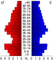
of 2000, there were 57,159 people, 22,671 households, and 15,779 families residing in the county. The population density
was 29 people per square mile (11/km²). There were 33,862 housing units at an average density of 17 per square mile (7/km²). The racial makeup of the county was 97.11% White, 0.29% African American, 0.51% Native American, 0.44% Asian, 0.05% Pacific Islander, 0.84% from other races
, and 0.78% from two or more races. Hispanic or Latino of any race were 1.67% of the population. 35.5% were of German and 31.2% Norwegian ancestry according to Census 2000.
 There were 22,671 households out of which 30.3% had children under the age of 18 living with them, 60.1% were married couples
living together, 6.1% had a female householder with no husband present, and 30.4% were non-families. 26.6% of all households were made up of individuals and 13.30% had someone living alone who was 65 years of age or older. The average household size was 2.46 and the average family size was 2.98.
In the county the population was spread out with 24.9% under the age of 18, 7.2% from 18 to 24, 24.2% from 25 to 44, 24.7% from 45 to 64, and 19.0% who were 65 years of age or older. The median age was 41 years. For every 100 females there were 100.4 males. For every 100 females age 18 and over, there were 97.8 males.
The median income for a household in the county was $35,395, and the median income for a family was $42,740. Males had a median income of $30,151 versus $20,930 for females. The per capita income
for the county was $18,014. About 6.7% of families and 10.1% of the population were below the poverty line, including 12.1% of those under age 18 and 11.1% of those age 65 or over.
During the time period of the Great Depression, however, there was actually a communist faction within the county. The areas where the movement was centered in the county are quite desolate today, however, during mid-1932, the worst possible time for farmers, there were over 900 members involved with one of the state's communist organizations. “The members of the communist party were very active in the New York Mills area of Newton, Leaf Lake, Blowers, Deer Creek and Paddock Townships. They held meetings, recruited members, placed candidates on local and state tickets, and distributed propaganda. They held dances in Heinola, Menahga, and Sebeka where the Soviet hammer and sickle was proudly displayed and ran a summer camp on East Leaf Lake.” Heinola is a ghost town today. The low activity and population among these areas today suggests that they were set up by outsiders during the Depression. When the communist movement died out, so did much of the activity and population has been on the decline ever since. This leads to the idea that the most of Otter Tail had strongly conservative roots; the few "communists" in the area were farmers under the influence of outsiders.
By the time Franklin D. Roosevelt implemented some of the New Deal programs in the county, most of the communist movement began to lose all its steam. In addition, the Winter War in Europe between Finland and the U.S.S.R. soured the taste of communism to many Finnish immigrants (the Fins were a major denomination among the communists at the time). Carl Peltoniemi, a former supporter of the organization, said, “The communist movement within the Finnish community basically ended at the start of the Winter War in 1939-1940.”
Ever since the United States presidential election of 1936, Otter Tail County has voted Republican for every Presidential election. In the U.S. Presidential Election of 2008, 55% of the voters voted for John McCain
while 42% voted for Barack Obama
.
In the Minnesota House of Representatives
, Otter Tail County is divided into two districts. District 10A and District 10B. Both are represented by Republicans
Bud Nornes (10A) and Mark Murdock (10B). Both Nornes and Murdock won the 2008 state House elections with more than 50% of the vote. Districts 10A and 10B make up the Minnesota State Senate district 10, which is represented by Republican State Senator Gretchen Hoffman. Senator Hoffman won the 2010 election with just under 55% of the votes.

† a part of Rothsay extends into Wilkin County
.
‡ Wadena is in Wadena County
, but a small part of the city extends into Otter Tail County.
U.S. state
A U.S. state is any one of the 50 federated states of the United States of America that share sovereignty with the federal government. Because of this shared sovereignty, an American is a citizen both of the federal entity and of his or her state of domicile. Four states use the official title of...
of Minnesota
Minnesota
Minnesota is a U.S. state located in the Midwestern United States. The twelfth largest state of the U.S., it is the twenty-first most populous, with 5.3 million residents. Minnesota was carved out of the eastern half of the Minnesota Territory and admitted to the Union as the thirty-second state...
. As of 2010, the population was 57,303. Its county seat
County seat
A county seat is an administrative center, or seat of government, for a county or civil parish. The term is primarily used in the United States....
is Fergus Falls
Fergus Falls, Minnesota
Fergus Falls is a city in and the county seat of Otter Tail County, Minnesota, United States. The population was 13,138 at the 2010 census.-Today:...
.
History
Native Americans used the survey area for hunting and fishing and had permanent dwelling sites. Two Native AmericanIndigenous peoples of the Americas
The indigenous peoples of the Americas are the pre-Columbian inhabitants of North and South America, their descendants and other ethnic groups who are identified with those peoples. Indigenous peoples are known in Canada as Aboriginal peoples, and in the United States as Native Americans...
tribes were in constant conflict. The Dakota (Sioux
Sioux
The Sioux are Native American and First Nations people in North America. The term can refer to any ethnic group within the Great Sioux Nation or any of the nation's many language dialects...
) were being pushed from their home area by the Ojibwa
Ojibwa
The Ojibwe or Chippewa are among the largest groups of Native Americans–First Nations north of Mexico. They are divided between Canada and the United States. In Canada, they are the third-largest population among First Nations, surpassed only by Cree and Inuit...
(Chippewa) during the late 18th century and early 19th century. Burial mounds and artifacts can still be found. Some of the oldest remains of Native Americans were found near Pelican Rapids, Minnesota
Pelican Rapids, Minnesota
As of the census of 2000, there were 2,374 people, 884 households, and 558 families residing in the city. The population density was 905.8 people per square mile . There were 962 housing units at an average density of 367.0 per square mile...
. The remains, nicknamed Minnesota Girl, were dated at about 11,000 B.C. (Otter Tail County Historical Museum).
The first white men to enter the county were French
French people
The French are a nation that share a common French culture and speak the French language as a mother tongue. Historically, the French population are descended from peoples of Celtic, Latin and Germanic origin, and are today a mixture of several ethnic groups...
and British
British people
The British are citizens of the United Kingdom, of the Isle of Man, any of the Channel Islands, or of any of the British overseas territories, and their descendants...
fur traders. Efforts were made to set up trading posts on the Leaf Lakes and Otter Tail Lake
Otter Tail Lake
Otter Tail Lake is a lake in the west-central part of the U.S. state of Minnesota and is the largest lake in Otter Tail County.- Geography :Adjoining the city of Ottertail, it is a part of the Otter Tail River chain of lakes. Upstream from the lake are Big Pine, Little Pine and Rush lakes, while...
. In the late 19th century, most of the towns were built along the railroad lines. Lumber and agriculture were the major industries in the county at that time. The pine and hardwood forests, transportation system, and markets were instrumental in the development of Fergus Falls into a lumber center.
In 1870, the population of the county was about 2,000. At that time the principal languages spoken in the county were Norwegian
Norwegian language
Norwegian is a North Germanic language spoken primarily in Norway, where it is the official language. Together with Swedish and Danish, Norwegian forms a continuum of more or less mutually intelligible local and regional variants .These Scandinavian languages together with the Faroese language...
, Swedish
Swedish language
Swedish is a North Germanic language, spoken by approximately 10 million people, predominantly in Sweden and parts of Finland, especially along its coast and on the Åland islands. It is largely mutually intelligible with Norwegian and Danish...
, German
German language
German is a West Germanic language, related to and classified alongside English and Dutch. With an estimated 90 – 98 million native speakers, German is one of the world's major languages and is the most widely-spoken first language in the European Union....
, and English
English language
English is a West Germanic language that arose in the Anglo-Saxon kingdoms of England and spread into what was to become south-east Scotland under the influence of the Anglian medieval kingdom of Northumbria...
. Otter Tail County was established in March 1858 by a legislative act. It was organized in 1868. The original county seat was Ottertail City.
The people of Fergus Falls organized a new county named Holcomb. In 1872, a legislative act abolished Holcomb County, added additional townships to the west, and established Fergus Falls as the county seat of Otter Tail County. There are 62 townships in the county. The county is named for Otter Tail Lake
Otter Tail Lake
Otter Tail Lake is a lake in the west-central part of the U.S. state of Minnesota and is the largest lake in Otter Tail County.- Geography :Adjoining the city of Ottertail, it is a part of the Otter Tail River chain of lakes. Upstream from the lake are Big Pine, Little Pine and Rush lakes, while...
and the Otter Tail River
Otter Tail River
The Otter Tail River is a river in the west-central portion of the U.S. state of Minnesota. It begins in Clearwater County, southwest of Bemidji...
.
Geography
According to the 2000 census, the county has a total area of 2224.91 square miles (5,762.5 km²), of which 1979.71 square miles (5,127.4 km²) (or 88.98%) is land and 245.2 square miles (635.1 km²) (or 11.02%) is water. According to the official web site, Otter Tail County contains over 1000 lakes and two Minnesota state parks, Maplewood State ParkMaplewood State Park
Maplewood State Park is a Minnesota state park near Pelican Rapids. The park preserves a pre-contact habitation site that was occupied in two different periods in a forest/prairie transition zone...
and Glendalough State Park
Glendalough State Park
Glendalough State Park is a state park of Minnesota, USA, in Otter Tail County near Battle Lake close to Minnesota State Highway 78. The park was once used as a resort and game farm by the owners of Cowles Media Company, owner of what is today the Star Tribune newspaper. The park contains on land...
. The highest point in Otter Tail County is Inspiration Peak
Inspiration Peak
Inspiration Peak is the highest peak of the Leaf Hills Moraines and of Otter Tail County in the U.S. State of Minnesota. It is 22 miles northwest of Alexandria. The peak rises about 400 feet above the surrounding plains, to an elevation of about 1750 feet above sea level...
in the Leaf Mountains
Leaf Hills Moraines
The Leaf Hills Moraines, sometimes called the Leaf Mountains, are a range of hills in west-central Minnesota. The land, while not exhibiting many characteristics of mountains, nevertheless rises typically to a height of to above the surrounding farmland through the duration of its range,...
, at 1750 feet above sea level.
Adjacent counties
- Becker CountyBecker County, MinnesotaBecker County is a county located in the U.S. state of Minnesota. As of 2010, the population was 32,504. Its county seat is Detroit Lakes. A portion of the White Earth Indian Reservation extends into the county.-History:...
(north) - Wadena CountyWadena County, MinnesotaAs of the census of 2000, there were 13,713 people, 5,426 households, and 3,608 families residing in the county. The population density was 26 people per square mile . There were 6,334 housing units at an average density of 12 per square mile...
(northeast) - Todd CountyTodd County, Minnesota-External links:*...
(southeast) - Douglas CountyDouglas County, MinnesotaAs of the census of 2000, there were 32,821 people, 13,276 households, and 9,027 families residing in the county. The population density was 52 people per square mile . There were 16,694 housing units at an average density of 26 per square mile...
(south) - Grant CountyGrant County, MinnesotaAs of the census of 2000, there were 6,289 people, 2,534 households, and 1,740 families residing in the county. The population density was 12 people per square mile . There were 3,098 housing units at an average density of 6 per square mile...
(southwest) - Wilkin CountyWilkin County, Minnesota-External links:*...
(west) - Clay CountyClay County, MinnesotaClay County is a county located in the U.S. state of Minnesota. As of 2010, the population was 58,999. Its name is in honor of American statesman Henry Clay, member of the United States Senate from Kentucky and United States Secretary of State in the 19th century. Its county seat is Moorhead...
(northwest)
Major highways
|
 Minnesota State Highway 106 Minnesota State Highway 106Minnesota State Highway 106 Minnesota State Highway 106 is a highway in west-central Minnesota, which runs from its intersection with State Highway 29 in Deer Creek and continues north to its northern terminus at its intersection with U.S...  Minnesota State Highway 108 Minnesota State Highway 108Minnesota State Highway 108 Minnesota State Highway 108 is a highway in west-central Minnesota, which runs from its interchange with Interstate Highway 94 at Prairie View Township near Rothsay and continues east to its eastern terminus at its intersection with State Highway 210 in Henning.Highway 108 is in length and passes...  Minnesota State Highway 210 Minnesota State Highway 210Minnesota State Highway 210 Minnesota State Highway 210 is a highway in west-central, central, and northeast Minnesota, which runs from North Dakota Highway 210 at the North Dakota state line , and continues east to its eastern terminus at its intersection with State Highway 23 in Duluth near the Saint Louis River.The route...  Minnesota State Highway 228 Minnesota State Highway 228Minnesota State Highway 228 Minnesota State Highway 228 is a highway in west-central Minnesota, which runs from its intersection with Otter Tail County Roads 4 and 17 in Vergas and continues east to its eastern terminus at its intersection with U.S...  Minnesota State Highway 235 Minnesota State Highway 235Minnesota State Highway 235 Minnesota State Highway 235 is a highway in west-central Minnesota, which runs from its intersection with Otter Tail County Road 59 in Urbank and continues east to its eastern terminus at its intersection with State Highway 29 in Parkers Prairie....  Minnesota State Highway 297 Minnesota State Highway 297 |

 U.S. Highway 10
 U.S. Highway 52
 U.S. Highway 59


Airports
The following public-use airports are located in Otter Tail County:- Fergus Falls Municipal AirportFergus Falls Municipal AirportFergus Falls Municipal Airport , also known as Einar Mickelson Field, is a public airport located three miles west of the central business district of Fergus Falls, a city in Otter Tail County, Minnesota, USA. The airport covers and has two runways. It is primarily used for general aviation...
(FFM) in Fergus FallsFergus Falls, MinnesotaFergus Falls is a city in and the county seat of Otter Tail County, Minnesota, United States. The population was 13,138 at the 2010 census.-Today:... - Henning Municipal Airport (05Y) in HenningHenning, MinnesotaHenning is a city in Otter Tail County, Minnesota, United States. The population was 802 at the 2010 census.-Geography:According to the United States Census Bureau, the city has a total area of , all of it land....
- New York Mills Municipal AirportNew York Mills Municipal AirportNew York Mills Municipal Airport is a city owned, public-use airport located two nautical miles southeast of the central business district of New York Mills, a city in Otter Tail County, Minnesota, United States.- Facilities and aircraft :...
(25Y) in New York MillsNew York Mills, MinnesotaNew York Mills is a city in Otter Tail County, Minnesota, United States. The population was 1,199 at the 2010 census.-Geography:According to the United States Census Bureau, the city has a total area of , all of it land.-Transportation:U.S... - Pelican Rapids Municipal AirportPelican Rapids Municipal AirportPelican Rapids Municipal Airport is a city-owned public-use airport located Four miles north of the central business district of Pelican Rapids, a city in Otter Tail County, Minnesota, United States.- Facilities and aircraft :...
(47Y) in Pelican RapidsPelican Rapids, MinnesotaAs of the census of 2000, there were 2,374 people, 884 households, and 558 families residing in the city. The population density was 905.8 people per square mile . There were 962 housing units at an average density of 367.0 per square mile... - Perham Municipal Airport (16D) in PerhamPerham, MinnesotaAs of the census of 2000, there were 2,559 people, 1,104 households, and 642 families residing in the city. The population density was 976.2 people per square mile . There were 1,167 housing units at an average density of 445.2 per square mile...
- Wadena Municipal AirportWadena Municipal AirportWadena Municipal Airport is a public airport located three miles west of the central business district of Wadena, a city in Otter Tail County, Minnesota, United States. It is owned by the City of Wadena.Although most U.S...
(ADC) in WadenaWadena, MinnesotaAs of the census of 2000, there were 4,294 people, 1,871 households, and 1,062 families residing in the city. The population density was 818.4 people per square mile . There were 1,964 housing units at an average density of 374.3 per square mile...
Demographics
As of the censusCensus
A census is the procedure of systematically acquiring and recording information about the members of a given population. It is a regularly occurring and official count of a particular population. The term is used mostly in connection with national population and housing censuses; other common...
of 2000, there were 57,159 people, 22,671 households, and 15,779 families residing in the county. The population density
Population density
Population density is a measurement of population per unit area or unit volume. It is frequently applied to living organisms, and particularly to humans...
was 29 people per square mile (11/km²). There were 33,862 housing units at an average density of 17 per square mile (7/km²). The racial makeup of the county was 97.11% White, 0.29% African American, 0.51% Native American, 0.44% Asian, 0.05% Pacific Islander, 0.84% from other races
Race (United States Census)
Race and ethnicity in the United States Census, as defined by the Federal Office of Management and Budget and the United States Census Bureau, are self-identification data items in which residents choose the race or races with which they most closely identify, and indicate whether or not they are...
, and 0.78% from two or more races. Hispanic or Latino of any race were 1.67% of the population. 35.5% were of German and 31.2% Norwegian ancestry according to Census 2000.
Marriage
Marriage is a social union or legal contract between people that creates kinship. It is an institution in which interpersonal relationships, usually intimate and sexual, are acknowledged in a variety of ways, depending on the culture or subculture in which it is found...
living together, 6.1% had a female householder with no husband present, and 30.4% were non-families. 26.6% of all households were made up of individuals and 13.30% had someone living alone who was 65 years of age or older. The average household size was 2.46 and the average family size was 2.98.
In the county the population was spread out with 24.9% under the age of 18, 7.2% from 18 to 24, 24.2% from 25 to 44, 24.7% from 45 to 64, and 19.0% who were 65 years of age or older. The median age was 41 years. For every 100 females there were 100.4 males. For every 100 females age 18 and over, there were 97.8 males.
The median income for a household in the county was $35,395, and the median income for a family was $42,740. Males had a median income of $30,151 versus $20,930 for females. The per capita income
Per capita income
Per capita income or income per person is a measure of mean income within an economic aggregate, such as a country or city. It is calculated by taking a measure of all sources of income in the aggregate and dividing it by the total population...
for the county was $18,014. About 6.7% of families and 10.1% of the population were below the poverty line, including 12.1% of those under age 18 and 11.1% of those age 65 or over.
Politics
In the U.S. presidential elections, Otter Tail County has mainly been a Republican county.During the time period of the Great Depression, however, there was actually a communist faction within the county. The areas where the movement was centered in the county are quite desolate today, however, during mid-1932, the worst possible time for farmers, there were over 900 members involved with one of the state's communist organizations. “The members of the communist party were very active in the New York Mills area of Newton, Leaf Lake, Blowers, Deer Creek and Paddock Townships. They held meetings, recruited members, placed candidates on local and state tickets, and distributed propaganda. They held dances in Heinola, Menahga, and Sebeka where the Soviet hammer and sickle was proudly displayed and ran a summer camp on East Leaf Lake.” Heinola is a ghost town today. The low activity and population among these areas today suggests that they were set up by outsiders during the Depression. When the communist movement died out, so did much of the activity and population has been on the decline ever since. This leads to the idea that the most of Otter Tail had strongly conservative roots; the few "communists" in the area were farmers under the influence of outsiders.
By the time Franklin D. Roosevelt implemented some of the New Deal programs in the county, most of the communist movement began to lose all its steam. In addition, the Winter War in Europe between Finland and the U.S.S.R. soured the taste of communism to many Finnish immigrants (the Fins were a major denomination among the communists at the time). Carl Peltoniemi, a former supporter of the organization, said, “The communist movement within the Finnish community basically ended at the start of the Winter War in 1939-1940.”
Ever since the United States presidential election of 1936, Otter Tail County has voted Republican for every Presidential election. In the U.S. Presidential Election of 2008, 55% of the voters voted for John McCain
John McCain
John Sidney McCain III is the senior United States Senator from Arizona. He was the Republican nominee for president in the 2008 United States election....
while 42% voted for Barack Obama
Barack Obama
Barack Hussein Obama II is the 44th and current President of the United States. He is the first African American to hold the office. Obama previously served as a United States Senator from Illinois, from January 2005 until he resigned following his victory in the 2008 presidential election.Born in...
.
In the Minnesota House of Representatives
Minnesota House of Representatives
The Minnesota House of Representatives is the lower house in the Minnesota State Legislature. There are 134 members elected to two-year terms, twice the number of members in the Minnesota Senate. Each senate district is divided in half and given the suffix A or B...
, Otter Tail County is divided into two districts. District 10A and District 10B. Both are represented by Republicans
Republican Party (United States)
The Republican Party is one of the two major contemporary political parties in the United States, along with the Democratic Party. Founded by anti-slavery expansion activists in 1854, it is often called the GOP . The party's platform generally reflects American conservatism in the U.S...
Bud Nornes (10A) and Mark Murdock (10B). Both Nornes and Murdock won the 2008 state House elections with more than 50% of the vote. Districts 10A and 10B make up the Minnesota State Senate district 10, which is represented by Republican State Senator Gretchen Hoffman. Senator Hoffman won the 2010 election with just under 55% of the votes.
| Year | Democrat Democratic Party (United States) The Democratic Party is one of two major contemporary political parties in the United States, along with the Republican Party. The party's socially liberal and progressive platform is largely considered center-left in the U.S. political spectrum. The party has the lengthiest record of continuous... |
Republican Republican Party (United States) The Republican Party is one of the two major contemporary political parties in the United States, along with the Democratic Party. Founded by anti-slavery expansion activists in 1854, it is often called the GOP . The party's platform generally reflects American conservatism in the U.S... |
|---|---|---|
| 2008 | 42% 13,856 | 55% 18,077 |
| 2004 | 37% 12,038 | 61% 19,734 |
| 2000 | 35% 9,176 | 59% 16,963 |
| 1996 | 40% 10,519 | 45% 11,808 |
| 1992 | 34% 9,844 | 41% 11,074 |
| 1988 | 42% 10,373 | 57% 14,015 |
| 1984 | 38% 9714 | 61% 15,664 |
| 1980 | 34% 9,108 | 57% 15,091 |
| 1976 | 48% 11,881 | 49% 12,113 |
| 1972 | 36% 7881 | 62% 13,519 |
| 1968 | 35% 7400 | 60% 12,483 |
| 1964 | 48% 9997 | 51% 10,542 |
| 1960 | 36% 8054 | 59% 16,080 |
Cities and towns
| Cities | Townships | Unincorporated | |
|---|---|---|---|
|
Dora Township, Otter Tail County, Minnesota Dora Township is a township in Otter Tail County, Minnesota, United States. The population was 726 at the 2000 census.-Geography:According to the United States Census Bureau, the township has a total area of , of which, of it is land and of it is water.-Demographics:As of the census of 2000,... |
Pelican Township, Otter Tail County, Minnesota Pelican Township is a township in Otter Tail County, Minnesota, United States. The population was 831 at the 2000 census.-Geography:According to the United States Census Bureau, the township has a total area of 33.2 square miles , of which, 31.2 square miles of it is land and... Pine Lake Township, Otter Tail County, Minnesota Pine Lake Township is a township in Otter Tail County, Minnesota, United States. The population was 656 at the 2000 census.-Geography:According to the United States Census Bureau, the township has a total area of 35.7 square miles , of which, 29.2 square miles of it is land and... Woodside Township, Otter Tail County, Minnesota Woodside Township is a township in Otter Tail County, Minnesota, United States. The population was 293 at the 2000 census.-Geography:According to the United States Census Bureau, the township has a total area of 36.2 square miles , all of it land.-Demographics:As of the census of 2000, there... |
Dunvilla, Minnesota Dunvilla is an unincorporated community in Otter Tail County, Minnesota, United States.The community is located between Detroit Lakes and Barnesville on Minnesota State Highway 34.Dunvilla is also located immediately north of Pelican Rapids on U.S. Route 59.... Parkton, Minnesota Parkton is a ghost town in Inman Township in Otter Tail County, Minnesota, United States.-Notes:... |
† a part of Rothsay extends into Wilkin County
Wilkin County, Minnesota
-External links:*...
.
‡ Wadena is in Wadena County
Wadena County, Minnesota
As of the census of 2000, there were 13,713 people, 5,426 households, and 3,608 families residing in the county. The population density was 26 people per square mile . There were 6,334 housing units at an average density of 12 per square mile...
, but a small part of the city extends into Otter Tail County.