

Otago Harbour
Encyclopedia
Otago Harbour is the natural harbour
of Dunedin
, New Zealand
, consisting of a long, much-indented stretch of generally navigable water separating the Otago Peninsula
from the mainland. They join at its southwest end, 21 km (13 mi) from the harbour mouth. It is home to the deep water port of Port Chalmers
.
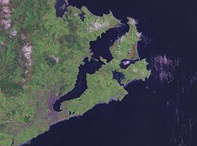 The harbour was formed from the drowned remnants of a giant shield volcano
, centred close to what is now the town of Port Chalmers
. The remains of this violent origin can be seen in the basalt
of the surrounding hills. The last eruptive phase ended some ten million years ago, leaving the prominent peak of Mount Cargill
.
Substantial container port facilities exist at Port Chalmers, 9 km (6 mi) along the western shore from the harbour mouth. A channel along the western side of the harbour is regularly dredged, allowing vessels with a draught of 12.5 m to Port Chalmers, and 8 m all the way to the heart of Dunedin. New Zealand's frozen meat export trade was inaugurated at Port Chalmers in 1882. The dredging of this channel, the Victoria Channel, was a major undertaking for the settlement of Dunedin in the 19th century. The eastern side of the harbour is shallow, with large sandbanks exposed at low tide.
Two islands form a line between Port Chalmers and Portobello
in the lower harbour - Goat Island
and Quarantine Island/Kamau Taurua. A smaller island known as Pudding Island (Titeramoa) lies close to the Peninsula shore and can be reached dry foot at low tide.
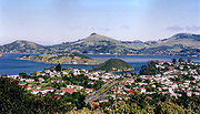
Portobello is home to one of New Zealand's leading marine research establishments, the Portobello Marine Laboratory
, a department of the University of Otago
. This lies at the harbour's edge on the tip of a small arm of the Otago Peninsula, the Portobello Peninsula.
Near the mouth of the harbour lies the township of Aramoana
(Maori
for "pathway to the sea"), infamous for a massacre
of 13 people by a gunman, David Gray, in November 1990.
This is also the site twice projected for New Zealand
's second aluminium
smelter. The proposals, in the mid 1970s and early 1980s, were abandoned after major public protest. The area is the home of many species of wading birds. Other species which visit the harbour include two species of penguins
, sea lions
, four species of seals, and several species of cetaceans(dolphins
and whales
) and Taiaroa Head
, at the tip of the Otago Peninsula, is home to a colony of Northern Royal Albatross
es, the only such close to a city in the world.
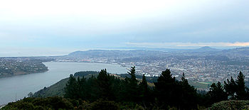
The harbour is tidal, shallow and seldom rough and for that reason is popular for water sports such as yachting
and windsurfing
.
A significant area at the head of the harbour has been reclaimed
since the founding of Dunedin, primarily for industrial use. Smaller portions have also been reclaimed at a number of places around the harbour, including Port Chalmers, Macandrew Bay, and Broad Bay.
 The existence of the harbour was guessed by Captain Cook when he was off what is now the Dunedin Pacific coast in 1770. It is not known when the first Europeans entered but it was some time 'long before' 1810, according to the Creed manuscript discovered in 2003. George Bass
made the Dunedin end of the harbour the north east limit of his proposed fishing monopoly in 1803. The American ship Favorite with its supercargo Daniel Whitney may have called in the summer of 1805 to 1806. Daniel Cooper, master of the London sealer Unity probably did call in the summer of 1808 to 1809 when his Chief Officer, Charles Hooper, probably gave his name to Hooper's Inlet on the Otago Peninsula
. William Tucker
(1784–1817) was with a gang employed by Robert Campbell
a Sydney merchant, dropped on islands off the Dunedin coast in November 1809 and with another man, Daniel Wilson, was at Otago Harbour on May the 3rd 1810 when Robert Mason, master of the Brothers anchored in the harbour and picked him up. This is the first, explicit and identifiable reference to a European ship in the Otago Harbour. The court record containing it, made in 1810, refers to the harbour as 'Port Daniel', a name which stayed in use for some years.
Another English sealer, the Sydney Cove, Captain Charles McLaren, was anchored in the harbour late in 1810 when Te Wahia's theft of a knife, a red shirt and some other articles sparked what has been called "The Sealers' War" - also - the 'War of the Shirt'.
A notable affray in that conflict occurred after James Kelly
of Hobart
anchored the Sophia in the harbour in December 1817 with William Tucker on board. After a visit to nearby Whareakeake (Murdering Beach) where Tucker had been living since 1815 and where he and two other men were now killed Kelly took revenge on Māori on his ship in the harbour, including a chief Korako. He then burnt a harbourside village,'the beautiful City of Otago', probably on Te Rauone Beach and certainly not at Whareakeake as has often been suggested.
A peace was concluded in 1823 and on 17 July of that year John Rodolphus Kent of the Naval cutter Mermaid from New South Wales
, while in the Harbour, took 'the liberty of naming it (as it has not hitherto been named) "Port Oxley", in honour of the Surveyor General of the Colony' in fact John Oxley
(1783/85?-1828). As noted, it had already been named. In 1826 Thomas Shepherd, one of a party of intending colonists, explored the site of Dunedin and left the oldest surviving pictures of the harbour and nearby coast, now in the Mitchell Library Sydney (Mitchell Library (Australia).
From its origins as a secret sealers' haven Otago Harbour developed into a busy international whaling port after the Weller brothers
established their whaling station at Te Umu Kuri, Wellers Rock, at what is now called Otakou
in November 1831. The busiest whaling port south of the Bay of Islands
, it was also the hub of the largest European population in New Zealand after the Bay of Islands/Hokianga
district by the end of 1839. By that time whaling had collapsed and Dumont D'Urville and his officers, visiting in 1840, observed the port had become the centre of a riotous trade in liquor and prostitution
. This continued until the Scottish settlers arrived in 1848 and made Port Chalmers and Dunedin the new population centres on the harbour.
Harbor
A harbor or harbour , or haven, is a place where ships, boats, and barges can seek shelter from stormy weather, or else are stored for future use. Harbors can be natural or artificial...
of Dunedin
Dunedin
Dunedin is the second-largest city in the South Island of New Zealand, and the principal city of the Otago Region. It is considered to be one of the four main urban centres of New Zealand for historic, cultural, and geographic reasons. Dunedin was the largest city by territorial land area until...
, New Zealand
New Zealand
New Zealand is an island country in the south-western Pacific Ocean comprising two main landmasses and numerous smaller islands. The country is situated some east of Australia across the Tasman Sea, and roughly south of the Pacific island nations of New Caledonia, Fiji, and Tonga...
, consisting of a long, much-indented stretch of generally navigable water separating the Otago Peninsula
Otago Peninsula
The Otago Peninsula is a long, hilly indented finger of land that forms the easternmost part of Dunedin, New Zealand. Volcanic in origin, it forms one wall of the eroded valley that now forms Otago Harbour. The peninsula lies south-east of Otago Harbour and runs parallel to the mainland for...
from the mainland. They join at its southwest end, 21 km (13 mi) from the harbour mouth. It is home to the deep water port of Port Chalmers
Port Chalmers
Port Chalmers is a suburb and the main port of the city of Dunedin, New Zealand, with a population of 3,000. Port Chalmers lies ten kilometres inside Otago Harbour, some 15 kilometres northeast from Dunedin's city centre....
.
Geography
Shield volcano
A shield volcano is a type of volcano usually built almost entirely of fluid lava flows. They are named for their large size and low profile, resembling a warrior's shield. This is caused by the highly fluid lava they erupt, which travels farther than lava erupted from more explosive volcanoes...
, centred close to what is now the town of Port Chalmers
Port Chalmers
Port Chalmers is a suburb and the main port of the city of Dunedin, New Zealand, with a population of 3,000. Port Chalmers lies ten kilometres inside Otago Harbour, some 15 kilometres northeast from Dunedin's city centre....
. The remains of this violent origin can be seen in the basalt
Basalt
Basalt is a common extrusive volcanic rock. It is usually grey to black and fine-grained due to rapid cooling of lava at the surface of a planet. It may be porphyritic containing larger crystals in a fine matrix, or vesicular, or frothy scoria. Unweathered basalt is black or grey...
of the surrounding hills. The last eruptive phase ended some ten million years ago, leaving the prominent peak of Mount Cargill
Mount Cargill
Mount Cargill is a 680 metre high volcanic outcrop which dominates the skyline of northern Dunedin, New Zealand. It is situated some 15 kilometres north of the city centre....
.
Substantial container port facilities exist at Port Chalmers, 9 km (6 mi) along the western shore from the harbour mouth. A channel along the western side of the harbour is regularly dredged, allowing vessels with a draught of 12.5 m to Port Chalmers, and 8 m all the way to the heart of Dunedin. New Zealand's frozen meat export trade was inaugurated at Port Chalmers in 1882. The dredging of this channel, the Victoria Channel, was a major undertaking for the settlement of Dunedin in the 19th century. The eastern side of the harbour is shallow, with large sandbanks exposed at low tide.
Two islands form a line between Port Chalmers and Portobello
Portobello, New Zealand
Portobello is a village beside the Otago Harbour halfway along the Otago Peninsula in Dunedin City, New Zealand. It lies at the foot of a small peninsula between Portobello Bay and Latham Bay....
in the lower harbour - Goat Island
Goat Island, Otago Harbour
Goat Island / Rakiriri is an island in Otago Harbour in Otago, in the southern South Island of New Zealand. It is located between Port Chalmers and Portobello, to the northeast of Dunedin's city centre....
and Quarantine Island/Kamau Taurua. A smaller island known as Pudding Island (Titeramoa) lies close to the Peninsula shore and can be reached dry foot at low tide.
Portobello is home to one of New Zealand's leading marine research establishments, the Portobello Marine Laboratory
Portobello Marine Laboratory
The Portobello Marine Laboratory is located on the end of a short peninsula close to the township of Portobello, within the limits of the city of Dunedin in New Zealand's South Island...
, a department of the University of Otago
University of Otago
The University of Otago in Dunedin is New Zealand's oldest university with over 22,000 students enrolled during 2010.The university has New Zealand's highest average research quality and in New Zealand is second only to the University of Auckland in the number of A rated academic researchers it...
. This lies at the harbour's edge on the tip of a small arm of the Otago Peninsula, the Portobello Peninsula.
Near the mouth of the harbour lies the township of Aramoana
Aramoana
Aramoana, also known as "The Spit" to locals, is a small coastal settlement, 27 kilometres north of Dunedin city, in the South Island of New Zealand. The settlement's permanent population in 2001 Census was 261. Supplementing this are seasonal visitors from the city who occupy cribs...
(Maori
Maori language
Māori or te reo Māori , commonly te reo , is the language of the indigenous population of New Zealand, the Māori. It has the status of an official language in New Zealand...
for "pathway to the sea"), infamous for a massacre
Aramoana massacre
The Aramoana massacre was a mass murder that occurred on 13 November 1990 in the small seaside township of Aramoana, New Zealand. Resident David Gray, a 33-year-old unemployed man, began indiscriminately shooting people in the township with a scoped semi-automatic rifle, after a verbal dispute with...
of 13 people by a gunman, David Gray, in November 1990.
This is also the site twice projected for New Zealand
New Zealand
New Zealand is an island country in the south-western Pacific Ocean comprising two main landmasses and numerous smaller islands. The country is situated some east of Australia across the Tasman Sea, and roughly south of the Pacific island nations of New Caledonia, Fiji, and Tonga...
's second aluminium
Aluminium
Aluminium or aluminum is a silvery white member of the boron group of chemical elements. It has the symbol Al, and its atomic number is 13. It is not soluble in water under normal circumstances....
smelter. The proposals, in the mid 1970s and early 1980s, were abandoned after major public protest. The area is the home of many species of wading birds. Other species which visit the harbour include two species of penguins
Little Penguin
The Little Penguin is the smallest species of penguin. The penguin, which usually grows to an average of in height and in length , is found on the coastlines of southern Australia and New Zealand, with possible records from Chile.Apart from Little Penguins, they have several common names...
, sea lions
New Zealand Sea Lion
The New Zealand Sea Lion also known as Hooker's Sea Lion or Whakahao in Māori is a species of sea lion that breeds around the coast of New Zealand's South Island and Stewart Island/Rakiura to some extent, and to a greater extent around the New Zealand Sub-Antarctic Islands, especially the Auckland...
, four species of seals, and several species of cetaceans(dolphins
Dusky Dolphin
The dusky dolphin is a dolphin found in coastal waters in the Southern Hemisphere. Its specific epithet is Latin for "dark" or "dim". It is very closely genetically related to the Pacific white-sided dolphin, but current scientific consensus is that they are distinct species...
and whales
Southern Right Whale
The southern right whale is a baleen whale, one of three species classified as right whales belonging to the genus Eubalaena. Like other right whales, the southern right whale is readily distinguished from others by the callosities on its head, a broad back without a dorsal fin, and a long arching...
) and Taiaroa Head
Taiaroa Head
Taiaroa Head is a headland at the end of the Otago Peninsula in New Zealand, overlooking the mouth of the Otago Harbour. It lies within the city limits of Dunedin...
, at the tip of the Otago Peninsula, is home to a colony of Northern Royal Albatross
Northern Royal Albatross
The Northern Royal Albatross or Toroa, Diomedea sanfordi, is a large seabird from the albatross family. It was split from the closely related Southern Royal Albatross as recently as 1998, though not all scientists support that conclusion and consider both of them to be subspecies of the Royal...
es, the only such close to a city in the world.
The harbour is tidal, shallow and seldom rough and for that reason is popular for water sports such as yachting
Yachting
Yachting refers to recreational sailing or boating, the specific act of sailing or using other water vessels for sporting purposes.-Competitive sailing:...
and windsurfing
Windsurfing
Windsurfing or sailboarding is a surface water sport that combines elements of surfing and sailing. It consists of a board usually two to four metres long, powered by the orthogonal effect of the wind on a sail. The rig is connected to the board by a free-rotating universal joint and comprises a...
.
A significant area at the head of the harbour has been reclaimed
Land reclamation
Land reclamation, usually known as reclamation, is the process to create new land from sea or riverbeds. The land reclaimed is known as reclamation ground or landfill.- Habitation :...
since the founding of Dunedin, primarily for industrial use. Smaller portions have also been reclaimed at a number of places around the harbour, including Port Chalmers, Macandrew Bay, and Broad Bay.
History
George Bass
George Bass was a British naval surgeon and explorer of Australia.-Early years:He was born on 30 January 1771 at Aswarby, a hamlet near Sleaford, Lincolnshire, the son of a tenant farmer, George Bass, and a local beauty named Sarah Nee Newman. His father died in 1777 when Bass was 6...
made the Dunedin end of the harbour the north east limit of his proposed fishing monopoly in 1803. The American ship Favorite with its supercargo Daniel Whitney may have called in the summer of 1805 to 1806. Daniel Cooper, master of the London sealer Unity probably did call in the summer of 1808 to 1809 when his Chief Officer, Charles Hooper, probably gave his name to Hooper's Inlet on the Otago Peninsula
Otago Peninsula
The Otago Peninsula is a long, hilly indented finger of land that forms the easternmost part of Dunedin, New Zealand. Volcanic in origin, it forms one wall of the eroded valley that now forms Otago Harbour. The peninsula lies south-east of Otago Harbour and runs parallel to the mainland for...
. William Tucker
William Tucker (settler)
William Tucker was a British convict, a sealer, a trader in human heads, an Otago settler, and New Zealand’s first art dealer....
(1784–1817) was with a gang employed by Robert Campbell
Robert Campbell
-Politicians:*Robert Campbell , Australian merchant/politician from New South Wales*Robert Campbell , New South Wales politician, son of the above*Robert Campbell , New York politician...
a Sydney merchant, dropped on islands off the Dunedin coast in November 1809 and with another man, Daniel Wilson, was at Otago Harbour on May the 3rd 1810 when Robert Mason, master of the Brothers anchored in the harbour and picked him up. This is the first, explicit and identifiable reference to a European ship in the Otago Harbour. The court record containing it, made in 1810, refers to the harbour as 'Port Daniel', a name which stayed in use for some years.
Another English sealer, the Sydney Cove, Captain Charles McLaren, was anchored in the harbour late in 1810 when Te Wahia's theft of a knife, a red shirt and some other articles sparked what has been called "The Sealers' War" - also - the 'War of the Shirt'.
A notable affray in that conflict occurred after James Kelly
James Kelly (Australian explorer)
James Kelly , Australian mariner, explorer and port official, was born on 24 December 1791 at Parramatta, New South Wales. He was probably the son of James Kelly, a cook in the convict transport Queen, and Catherine Devereaux, a convict transported for life from Dublin in the same ship.Kelly was...
of Hobart
Hobart
Hobart is the state capital and most populous city of the Australian island state of Tasmania. Founded in 1804 as a penal colony,Hobart is Australia's second oldest capital city after Sydney. In 2009, the city had a greater area population of approximately 212,019. A resident of Hobart is known as...
anchored the Sophia in the harbour in December 1817 with William Tucker on board. After a visit to nearby Whareakeake (Murdering Beach) where Tucker had been living since 1815 and where he and two other men were now killed Kelly took revenge on Māori on his ship in the harbour, including a chief Korako. He then burnt a harbourside village,'the beautiful City of Otago', probably on Te Rauone Beach and certainly not at Whareakeake as has often been suggested.
A peace was concluded in 1823 and on 17 July of that year John Rodolphus Kent of the Naval cutter Mermaid from New South Wales
New South Wales
New South Wales is a state of :Australia, located in the east of the country. It is bordered by Queensland, Victoria and South Australia to the north, south and west respectively. To the east, the state is bordered by the Tasman Sea, which forms part of the Pacific Ocean. New South Wales...
, while in the Harbour, took 'the liberty of naming it (as it has not hitherto been named) "Port Oxley", in honour of the Surveyor General of the Colony' in fact John Oxley
John Oxley
John Joseph William Molesworth Oxley was an explorer and surveyor of Australia in the early period of English colonisation.October 1802 he was engaged in coastal survey work including an expedition to Western Port in 1804-05...
(1783/85?-1828). As noted, it had already been named. In 1826 Thomas Shepherd, one of a party of intending colonists, explored the site of Dunedin and left the oldest surviving pictures of the harbour and nearby coast, now in the Mitchell Library Sydney (Mitchell Library (Australia).
From its origins as a secret sealers' haven Otago Harbour developed into a busy international whaling port after the Weller brothers
Weller brothers
The Weller brothers, Englishmen of Sydney and Otago, New Zealand, were the founders of a whaling station on Otago Harbour and New Zealand’s most substantial merchant traders in the 1830s.-Immigration:...
established their whaling station at Te Umu Kuri, Wellers Rock, at what is now called Otakou
Otakou
The settlement of Otakou lies within the boundaries of the city of Dunedin, New Zealand. It is located 25 kilometres from the city centre at the eastern end of Otago Peninsula, close to the entrance of Otago Harbour.-Overview:...
in November 1831. The busiest whaling port south of the Bay of Islands
Bay of Islands
The Bay of Islands is an area in the Northland Region of the North Island of New Zealand. Located 60 km north-west of Whangarei, it is close to the northern tip of the country....
, it was also the hub of the largest European population in New Zealand after the Bay of Islands/Hokianga
Hokianga
Hokianga is an area surrounding the Hokianga Harbour, also known as The Hokianga River, a long estuarine drowned valley on the west coast in the north of the North Island of New Zealand....
district by the end of 1839. By that time whaling had collapsed and Dumont D'Urville and his officers, visiting in 1840, observed the port had become the centre of a riotous trade in liquor and prostitution
Prostitution
Prostitution is the act or practice of providing sexual services to another person in return for payment. The person who receives payment for sexual services is called a prostitute and the person who receives such services is known by a multitude of terms, including a "john". Prostitution is one of...
. This continued until the Scottish settlers arrived in 1848 and made Port Chalmers and Dunedin the new population centres on the harbour.
Harbourside settlements
Settlements by the harbour include (in order from the mouth of the harbour):- On the western shore:
- AramoanaAramoanaAramoana, also known as "The Spit" to locals, is a small coastal settlement, 27 kilometres north of Dunedin city, in the South Island of New Zealand. The settlement's permanent population in 2001 Census was 261. Supplementing this are seasonal visitors from the city who occupy cribs...
- Careys Bay
- Port ChalmersPort ChalmersPort Chalmers is a suburb and the main port of the city of Dunedin, New Zealand, with a population of 3,000. Port Chalmers lies ten kilometres inside Otago Harbour, some 15 kilometres northeast from Dunedin's city centre....
- Sawyers BaySawyers BaySawyers Bay is a suburb of the New Zealand city of Dunedin. It is located to the southwest of Port Chalmers in a wide valley on the shore of Mussel Bay, to the northeast of Dunedin city centre....
(with a tannery) - RoseneathRoseneath, OtagoRoseneath is a small suburb of the New Zealand city of Dunedin, located on the northwestern shore of Otago Harbour, to the northeast of Dunedin city centre. It is situated between Saint Leonards and Port Chalmers on a rocky promontory of the same name which juts into the harbour between Sawyers...
- Saint Leonards
- RavensbourneRavensbourne, New ZealandRavensbourne is a suburb of the New Zealand city of Dunedin. It is located on the steep southeastern slopes of Signal Hill above the Otago Harbour. It lies on the harbour's northern shore, east-northeast of the city centre...
(with a fertiliser works)
- Aramoana
- On the eastern shore:
- Harington Point
- Weller's Rock (With access to the albatross colony, seal colony, and Fort Taiaroa)
- OtakouOtakouThe settlement of Otakou lies within the boundaries of the city of Dunedin, New Zealand. It is located 25 kilometres from the city centre at the eastern end of Otago Peninsula, close to the entrance of Otago Harbour.-Overview:...
- Harwood
- PortobelloPortobello, New ZealandPortobello is a village beside the Otago Harbour halfway along the Otago Peninsula in Dunedin City, New Zealand. It lies at the foot of a small peninsula between Portobello Bay and Latham Bay....
- Broad BayBroad Bay, New ZealandThe settlement of Broad Bay is located on the Otago Harbour coast of Otago Peninsula, in the South Island of New Zealand. It is administered as part of the city of Dunedin, and is technically a suburb of that city, though its isolation and semi-rural nature make it appear as a settlement in its own...
- Macandrew Bay
- ChallisChallis, New Zealand"The Cove, New Zealand" redirects here. For other things called "The Cove", see Cove Challis is a settlement on the Otago Harbour coast of Otago Peninsula, within the city limits of the New Zealand city of Dunedin...
- Andersons BayAndersons BayAndersons Bay is a suburb of the New Zealand city of Dunedin. It is located in the southeast of the city's urban area, southeast of the city's centre...