

Osgathorpe
Encyclopedia
North West Leicestershire
North West Leicestershire is a local government district in Leicestershire, England. Its main towns are Ashby-de-la-Zouch and Coalville.The district contains East Midlands Airport, which operates flights to the rest of Britain and to various places in Europe...
, England
England
England is a country that is part of the United Kingdom. It shares land borders with Scotland to the north and Wales to the west; the Irish Sea is to the north west, the Celtic Sea to the south west, with the North Sea to the east and the English Channel to the south separating it from continental...
, and is about a quarter of a mile the A512
A512 road
The A512 is an A road entirely in Leicestershire, UK. It links the primary destination of Loughborough with the M1, A42 road, and the town of Ashby de la Zouch....
Coalville
Coalville
Coalville is a town in North West Leicestershire, England, with a population estimated in 2003 to be almost 33,000. It is situated on the A511 trunk road between Leicester and Burton upon Trent, close to junction 22 of the M1 motorway where the A511 meets the A50 between Ashby-de-la-Zouch and...
to Loughborough
Loughborough
Loughborough is a town within the Charnwood borough of Leicestershire, England. It is the seat of Charnwood Borough Council and is home to Loughborough University...
Road.
The parish church is dedicated to Saint Mary the Blessed Virgin and dates from the fourteenth century. It was heavily restored
Victorian restoration
Victorian restoration is the term commonly used to refer to the widespread and extensive refurbishment and rebuilding of Church of England churches and cathedrals that took place in England and Wales during the 19th-century reign of Queen Victoria...
in the nineteenth century, with the addition of a polygonal apse to the chancel. A tower with a small pyramid turret was built at the south west corner of the church in around 1930 and contains two bells, which are rung using a clocking method.
There are pleasing north and south windows to the nave and chancel, and in the south wall of the nave can be seen a very unusual hagioscope (or squint), which is set diagonally within the stonework, to allow a view of the altar.
Opposite the church is the village school, built in 1670, with almshouses of the same date. There is also a good example of a sixteenth century yeoman farmer's house just south-west of the church, with a fine Swithland slate roof.
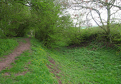
Remains of a stretch of the long-abandoned Charnwood Forest Canal
Charnwood Forest Canal
The Charnwood Forest Canal, sometimes known as the "Forest Line of the Leicester Navigation", was opened between Thringstone and Nanpantan, with a further connection to Barrow Hill, near Worthington, in 1794...
can be seen alongside a footpath to the south of the village, running from Thringstone
Thringstone
Thringstone is a village in north-west Leicestershire, England about north of Coalville. It lies within the area of the English National Forest and is part of the East Midlands region....
to an area known locally as 'The Snarrows'.
The Storey Arms was a popular working class pub but now struggles to attract drinkers due to the clampdown on drink driving and the other pub the Royal Oak closed in 2000.