
Operation Meghdoot
Encyclopedia
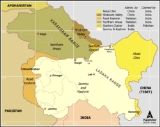
Operation Meghdoot was the name given to the attack launched by the Indian Military to capture the Siachen Glacier
in the disputed Kashmir
region, precipitating the Siachen Conflict
. Launched on 13 April 1984, this military operation
was unique as the first assault launched in the world's highest battlefield. The military action eventually resulted in Indian troops managing to gain control of the entire Siachen Glacier
.
Today, the occupation of locations along what is known as the Actual Ground Position Line
(AGPL) continues to be known as Operation Meghdoot, with up to 10 Infantry Battalions each of the Indian Army
and Pakistani Army actively deployed in altitudes up to 6,400 metres (21,000 ft).
became a bone of contention following a vague demarcation of territory as per the Simla Agreement of 1972, which did not exactly specify who had authority over the Siachen Glacier
area. As a result of this, both nations lay claim to the barren land. In the 1970s and early 80s, Pakistan
permitted several mountaineering
expeditions to climb the peaks in the Siachen region. This served to reinforce their claim on the area as these expeditions arrived on the glacier with a permit obtained from the Government of Pakistan
. In 1978 the Indian Army also allowed mountaineering expeditions to the glacier, approaching from its side. The most notable one was the one launched by Colonel N. Kumar of the Indian Army, who mounted an Army expedition to Teram Kangri
. Subsequently, due to this Indian Army expedition, the issue was aggravated and turned into a conflict, Siachen Conflict.
Notably, when Pakistan gave permission to a Japan
ese expedition to scale an important peak (Rimo I
) in 1984, it further led to emergence of suspected thoughts of Indian Government. The peak, located east of the Siachen Glacier
, also overlooks the northwestern areas of the Aksai Chin
area which is occupied by China
but claimed by India
. The Indian military hypothetically believed that such an expedition could further a link for a trade route from the southwestern (Pakistani) to the northeastern (Chinese) side of the Karakoram Range and eventually provide a strategic, if not tactical, advantage to the Pakistani Armed Forces.
region as well as some paramilitary forces. Most of the troops had already been acclimatized to the extremities of the glacier after having been sent on a training expedition to Antarctica in 1982. Pakistan, meanwhile, felt that the Indians were planning to capture key ridge
s and passes
near the glacier after the Indian Army's mountaineering expedition and accordingly decided to send its own troops to the glacier.
On 13 April 1984, the Indian Army made its move onto the glacier to defend the territory and the peaks and passes around it when it launched "Operation Meghdoot". The operation was launched under the command of Lieutenant General P N Hoon, the then army commander of the Indian Army's Northern Command based at Udhampur in Jammu & Kashmir in India. The operation was also based on intelligence inputs that Pakistan was also preparing for an action in these areas. Reportedly the operation pre empted Pakistani Army by about 4 days, as intelligence reported that Pakistan was to launch an operation on 17 April 1984. Named after the divine cloud messenger (Meghaduuta) in a Sanskrit
play
, the operation involved the airlifting of Indian Army
soldiers by the Indian Air Force
(IAF) and dropping them in the glacial area. The IAF used planes such as the Il-76, An-12
and An-32
to transport stores and troops as well to airdrop supplies to high altitude airfields. Helicopters like Mi-17
, Mi-8
, Chetak
and Cheetah
carried provisions and personnel to areas near hitherto unscaled peaks. Approximately 300 troops were soon up on the important peaks and passes of the glacier. By the time Pakistan troops managed to get into the immediate area, they found that the Indian troops had occupied the major mountain passes on the Saltoro Ridge west of Siachen Glacier
. Handicapped by the altitude and the limited time, Pakistan could only manage to control the Saltoro Ridge's
western slopes and foothills despite the fact that Pakistan possessed more accessible routes to the area, unlike Indian access to the Siachen which was largely reliant on air drops.
In his memoirs, former Pakistani president
, General Pervez Musharraf
states that Pakistan lost almost 900 sq mi (2,331 km²) of territory. TIME
states that the Indian advance captured nearly 1000 sq mi (2,590 km²) of territory claimed by Pakistan. Camps were soon converted to permanent posts by both countries. The number of casualties on both sides during this particular operation is not known.
, Bilafond La
, and Gyong La
, thus holding onto the tactical advantage of high ground...
The operation and the continued cost of maintaining logistics to the area is a major drain on both militaries. Pakistan launched an all out assault in 1987 and again in 1989 to capture the ridge and passes held by India. The first assault was headed by then-Brigadier-General Pervez Musharraf
(later President of Pakistan
) and initially managed to capture a few high points before being beaten back. Later the same year, Pakistan lost at least one major Pakistani post, the "Quaid", which came under Indian control as Bana Post, in recognition of Subedar Major Bana Singh
who launched a daring daylight attack, codenamed "Operation Rajiv", after climbing 1500 ft (457.2 m) of ice cliff. The only Param Vir Chakra (PVC) — the highest gallantry award of India — in the ongoing battle was awarded to then Naib Subedar Bana Singh who was instrumental in capturing the post. Bana Post is the highest battlefield post in the world today at a height of 22143 feet (6,749.2 m) above sea level.http://in.rediff.com/news/2001/jan/25hope.htmhttp://www.bharat-rakshak.com/LAND-FORCES/Army/History/1984/Siachen.html The second assault in 1989 was also unsuccessful as the ground positions did not change. The loss of most of the Siachen area and the subsequent unsuccessful military forays prompted Benazir Bhutto
to taunt Zia ul Haq
that he should wear a burqa
as he had lost his manliness
.
Operation Meghdoot was seen by some as the blueprint behind the Kargil War
in 1999 when Pakistan backed guerrillas and paramilitary forces covertly occupied the Kargil region. It is said that Operation Meghdoot was the inspiration for this abortive operation in Kargil launched by Pakistan later in 1999. Despite this, some obvious similarities do exist between Siachen and Kargil, including their preemptive nature and the tactical advantage held by the entity who holds the heights. But while Operation Meghdoot was launched in an area of ambiguous border demarcation, the Line of Control
in the Kargil region
is clearly demarcated and therefore India received complete international support during the Kargil episode.
, high altitude sickness and falling into a crevasse
during patrols.
Siachen Glacier
The Siachen Glacier is located in the eastern Karakoram range in the Himalaya Mountains at about , just east of the Line of Control between India-Pakistan. India controls all of the Siachen Glacier itself, including all tributary glaciers. At long, it is the longest glacier in the Karakoram and...
in the disputed Kashmir
Kashmir
Kashmir is the northwestern region of the Indian subcontinent. Until the mid-19th century, the term Kashmir geographically denoted only the valley between the Great Himalayas and the Pir Panjal mountain range...
region, precipitating the Siachen Conflict
Siachen conflict
The Siachen Conflict, sometimes referred to as the Siachen War, is a military conflict between India and Pakistan over the disputed Siachen Glacier region in Kashmir. The conflict began in 1984 with India's successful Operation Meghdoot during which it wrested control of the Siachen Glacier from...
. Launched on 13 April 1984, this military operation
Military operation
Military operation is the coordinated military actions of a state in response to a developing situation. These actions are designed as a military plan to resolve the situation in the state's favor. Operations may be of combat or non-combat types, and are referred to by a code name for the purpose...
was unique as the first assault launched in the world's highest battlefield. The military action eventually resulted in Indian troops managing to gain control of the entire Siachen Glacier
Siachen Glacier
The Siachen Glacier is located in the eastern Karakoram range in the Himalaya Mountains at about , just east of the Line of Control between India-Pakistan. India controls all of the Siachen Glacier itself, including all tributary glaciers. At long, it is the longest glacier in the Karakoram and...
.
Today, the occupation of locations along what is known as the Actual Ground Position Line
Actual Ground Position Line
The Actual Ground Position Line refers to the current position that divides Indian and Pakistani troops at the Siachen Glacier. The line extends from the northernmost point of the LOC to Indira Col.-History:...
(AGPL) continues to be known as Operation Meghdoot, with up to 10 Infantry Battalions each of the Indian Army
Indian Army
The Indian Army is the land based branch and the largest component of the Indian Armed Forces. With about 1,100,000 soldiers in active service and about 1,150,000 reserve troops, the Indian Army is the world's largest standing volunteer army...
and Pakistani Army actively deployed in altitudes up to 6,400 metres (21,000 ft).
Cause of conflict
The Siachen GlacierSiachen Glacier
The Siachen Glacier is located in the eastern Karakoram range in the Himalaya Mountains at about , just east of the Line of Control between India-Pakistan. India controls all of the Siachen Glacier itself, including all tributary glaciers. At long, it is the longest glacier in the Karakoram and...
became a bone of contention following a vague demarcation of territory as per the Simla Agreement of 1972, which did not exactly specify who had authority over the Siachen Glacier
Siachen Glacier
The Siachen Glacier is located in the eastern Karakoram range in the Himalaya Mountains at about , just east of the Line of Control between India-Pakistan. India controls all of the Siachen Glacier itself, including all tributary glaciers. At long, it is the longest glacier in the Karakoram and...
area. As a result of this, both nations lay claim to the barren land. In the 1970s and early 80s, Pakistan
Pakistan
Pakistan , officially the Islamic Republic of Pakistan is a sovereign state in South Asia. It has a coastline along the Arabian Sea and the Gulf of Oman in the south and is bordered by Afghanistan and Iran in the west, India in the east and China in the far northeast. In the north, Tajikistan...
permitted several mountaineering
Mountaineering
Mountaineering or mountain climbing is the sport, hobby or profession of hiking, skiing, and climbing mountains. While mountaineering began as attempts to reach the highest point of unclimbed mountains it has branched into specialisations that address different aspects of the mountain and consists...
expeditions to climb the peaks in the Siachen region. This served to reinforce their claim on the area as these expeditions arrived on the glacier with a permit obtained from the Government of Pakistan
Government of Pakistan
The Government of Pakistan is a federal parliamentary system, with an indirectly-elected President as the Head of State and Commander in Chief of the Pakistani Armed Forces, and an indirectly-elected Prime Minister as the Head of Government. The President’s appointment and term are...
. In 1978 the Indian Army also allowed mountaineering expeditions to the glacier, approaching from its side. The most notable one was the one launched by Colonel N. Kumar of the Indian Army, who mounted an Army expedition to Teram Kangri
Teram Kangri
The Teram Kangri group is a mountain massif in the remote Siachen Muztagh, a subrange of the Karakoram range. The high point of the group, and of the Siachen Muztagh, is Teram Kangri I. The peak lies on the boundary between China and the disputed Siachen Glacier region near the line of control...
. Subsequently, due to this Indian Army expedition, the issue was aggravated and turned into a conflict, Siachen Conflict.
Notably, when Pakistan gave permission to a Japan
Japan
Japan is an island nation in East Asia. Located in the Pacific Ocean, it lies to the east of the Sea of Japan, China, North Korea, South Korea and Russia, stretching from the Sea of Okhotsk in the north to the East China Sea and Taiwan in the south...
ese expedition to scale an important peak (Rimo I
Rimo I
Rimo I is the main summit of the Rimo massif with an elevation of . It lies in the northern part of the remote Rimo Muztagh, a subrange of the Karakoram range. It is located about 20 km northeast of the snout of the Siachen Glacier...
) in 1984, it further led to emergence of suspected thoughts of Indian Government. The peak, located east of the Siachen Glacier
Siachen Glacier
The Siachen Glacier is located in the eastern Karakoram range in the Himalaya Mountains at about , just east of the Line of Control between India-Pakistan. India controls all of the Siachen Glacier itself, including all tributary glaciers. At long, it is the longest glacier in the Karakoram and...
, also overlooks the northwestern areas of the Aksai Chin
Aksai Chin
Aksai Chin is one of the two main disputed border areas between China and India, and the other is South Tibet, which comprises most of India's Arunachal Pradesh. It is administered by China as part of Hotan County in the Hotan Prefecture of Xinjiang Autonomous Region, but is also claimed by India...
area which is occupied by China
China
Chinese civilization may refer to:* China for more general discussion of the country.* Chinese culture* Greater China, the transnational community of ethnic Chinese.* History of China* Sinosphere, the area historically affected by Chinese culture...
but claimed by India
India
India , officially the Republic of India , is a country in South Asia. It is the seventh-largest country by geographical area, the second-most populous country with over 1.2 billion people, and the most populous democracy in the world...
. The Indian military hypothetically believed that such an expedition could further a link for a trade route from the southwestern (Pakistani) to the northeastern (Chinese) side of the Karakoram Range and eventually provide a strategic, if not tactical, advantage to the Pakistani Armed Forces.
The operation
The Indian Military decided to take action to stop future expeditions from the Pakistani side and eventually to prevent Pakistan from staking its claim on the glacier. Accordingly, the Indian military brought to the glacier area troops from Northern LadakhLadakh
Ladakh is a region of Jammu and Kashmir, the northernmost state of the Republic of India. It lies between the Kunlun mountain range in the north and the main Great Himalayas to the south, inhabited by people of Indo-Aryan and Tibetan descent...
region as well as some paramilitary forces. Most of the troops had already been acclimatized to the extremities of the glacier after having been sent on a training expedition to Antarctica in 1982. Pakistan, meanwhile, felt that the Indians were planning to capture key ridge
Ridge
A ridge is a geological feature consisting of a chain of mountains or hills that form a continuous elevated crest for some distance. Ridges are usually termed hills or mountains as well, depending on size. There are several main types of ridges:...
s and passes
Mountain pass
A mountain pass is a route through a mountain range or over a ridge. If following the lowest possible route, a pass is locally the highest point on that route...
near the glacier after the Indian Army's mountaineering expedition and accordingly decided to send its own troops to the glacier.
On 13 April 1984, the Indian Army made its move onto the glacier to defend the territory and the peaks and passes around it when it launched "Operation Meghdoot". The operation was launched under the command of Lieutenant General P N Hoon, the then army commander of the Indian Army's Northern Command based at Udhampur in Jammu & Kashmir in India. The operation was also based on intelligence inputs that Pakistan was also preparing for an action in these areas. Reportedly the operation pre empted Pakistani Army by about 4 days, as intelligence reported that Pakistan was to launch an operation on 17 April 1984. Named after the divine cloud messenger (Meghaduuta) in a Sanskrit
Sanskrit
Sanskrit , is a historical Indo-Aryan language and the primary liturgical language of Hinduism, Jainism and Buddhism.Buddhism: besides Pali, see Buddhist Hybrid Sanskrit Today, it is listed as one of the 22 scheduled languages of India and is an official language of the state of Uttarakhand...
play
Play (theatre)
A play is a form of literature written by a playwright, usually consisting of scripted dialogue between characters, intended for theatrical performance rather than just reading. There are rare dramatists, notably George Bernard Shaw, who have had little preference whether their plays were performed...
, the operation involved the airlifting of Indian Army
Indian Army
The Indian Army is the land based branch and the largest component of the Indian Armed Forces. With about 1,100,000 soldiers in active service and about 1,150,000 reserve troops, the Indian Army is the world's largest standing volunteer army...
soldiers by the Indian Air Force
Indian Air Force
The Indian Air Force is the air arm of the Indian armed forces. Its primary responsibility is to secure Indian airspace and to conduct aerial warfare during a conflict...
(IAF) and dropping them in the glacial area. The IAF used planes such as the Il-76, An-12
Antonov An-12
The Antonov An-12 is a four-engined turboprop transport aircraft designed in the Soviet Union. It is the military version of the Antonov An-10.-Design and development:...
and An-32
Antonov An-32
The Antonov An-32 is a twin-engined turboprop military transport aircraft.-Design and development:The An-32 is basically a re-engined An-26. The launch customer was the Indian Air Force, which ordered this aircraft partly due to good relations between then USSR leader Leonid Brezhnev and then...
to transport stores and troops as well to airdrop supplies to high altitude airfields. Helicopters like Mi-17
Mil Mi-17
The Mil Mi-17 is a Russian helicopter currently in production at two factories in Kazan and Ulan-Ude...
, Mi-8
Mil Mi-8
The Mil Mi-8 is a medium twin-turbine transport helicopter that can also act as a gunship. The Mi-8 is the world's most-produced helicopter, and is used by over 50 countries. Russia is the largest operator of the Mi-8/Mi-17 helicopter....
, Chetak
Chetak
Chetak is the name of all of the following:*Chetak The horse of Rana Pratap, famous in Indian folk-legend. Pratap was mounted on Chetak during the gruesome Battle of Haldighati , fought between his army and the Mughal forces. This famous war horse was of Marwari breed.* HAL Chetak is a make of...
and Cheetah
Aérospatiale Lama
|-See also:-External links:...
carried provisions and personnel to areas near hitherto unscaled peaks. Approximately 300 troops were soon up on the important peaks and passes of the glacier. By the time Pakistan troops managed to get into the immediate area, they found that the Indian troops had occupied the major mountain passes on the Saltoro Ridge west of Siachen Glacier
Siachen Glacier
The Siachen Glacier is located in the eastern Karakoram range in the Himalaya Mountains at about , just east of the Line of Control between India-Pakistan. India controls all of the Siachen Glacier itself, including all tributary glaciers. At long, it is the longest glacier in the Karakoram and...
. Handicapped by the altitude and the limited time, Pakistan could only manage to control the Saltoro Ridge's
Saltoro Mountains
The Saltoro Mountains are a subrange of the Karakoram Range. They are located in the heart of the Karakoram, on the southwest side of the Siachen Glacier, one of the longest glaciers outside of the polar regions.They are claimed as part of Jammu and Kashmir by India and as part of Gilgit-Baltistan...
western slopes and foothills despite the fact that Pakistan possessed more accessible routes to the area, unlike Indian access to the Siachen which was largely reliant on air drops.
In his memoirs, former Pakistani president
President of Pakistan
The President of Pakistan is the head of state, as well as figurehead, of the Islamic Republic of Pakistan. Recently passed an XVIII Amendment , Pakistan has a parliamentary democratic system of government. According to the Constitution, the President is chosen by the Electoral College to serve a...
, General Pervez Musharraf
Pervez Musharraf
Pervez Musharraf , is a retired four-star general who served as the 13th Chief of Army Staff and tenth President of Pakistan as well as tenth Chairman of the Joint Chiefs of Staff Committee. Musharraf headed and led an administrative military government from October 1999 till August 2007. He ruled...
states that Pakistan lost almost 900 sq mi (2,331 km²) of territory. TIME
Time
Time is a part of the measuring system used to sequence events, to compare the durations of events and the intervals between them, and to quantify rates of change such as the motions of objects....
states that the Indian advance captured nearly 1000 sq mi (2,590 km²) of territory claimed by Pakistan. Camps were soon converted to permanent posts by both countries. The number of casualties on both sides during this particular operation is not known.
Aftermath
There are divergent views on the strategic value of the Operation. Some view it as a futile capture of non-strategic land which antagonized relations between India & Pakistan. Others consider the operation to be a "daring" success by the Indian Military and ensured that the Indian military held tactical high ground on the strategic Saltoro Ridge just west of the glacier, albeit at a high cost. The Indian Army currently controls all of the 70 kilometres (43.5 mi) long Siachen Glacier and all of its tributary glaciers, as well as the three main passes of the Saltoro Ridge immediately west of the glacier, Sia LaSia La
Sia La is a mountain pass situated on Saltoro Ridge, some north-northwest of map point NJ 980420 which defined the end of the 1972 Line of Control between India and Pakistan as part of the Simla Agreement...
, Bilafond La
Bilafond La
Bilafond La , also known as the Saltoro Pass, is a mountain pass situated on Saltoro Ridge, sitting immediately west of the vast Siachen Glacier, some directly north of map point NJ 980420 which defined the end of the 1972 Line of Control between Pakistan and India as part of the Simla...
, and Gyong La
Gyong La
Gyong La is a mountain pass situated on Saltoro Ridge, sitting southwest of the vast Siachen Glacier, some directly north of map point NJ 980420 which defined the end of the 1972 Line of Control between India and Pakistan...
, thus holding onto the tactical advantage of high ground...
The operation and the continued cost of maintaining logistics to the area is a major drain on both militaries. Pakistan launched an all out assault in 1987 and again in 1989 to capture the ridge and passes held by India. The first assault was headed by then-Brigadier-General Pervez Musharraf
Pervez Musharraf
Pervez Musharraf , is a retired four-star general who served as the 13th Chief of Army Staff and tenth President of Pakistan as well as tenth Chairman of the Joint Chiefs of Staff Committee. Musharraf headed and led an administrative military government from October 1999 till August 2007. He ruled...
(later President of Pakistan
President of Pakistan
The President of Pakistan is the head of state, as well as figurehead, of the Islamic Republic of Pakistan. Recently passed an XVIII Amendment , Pakistan has a parliamentary democratic system of government. According to the Constitution, the President is chosen by the Electoral College to serve a...
) and initially managed to capture a few high points before being beaten back. Later the same year, Pakistan lost at least one major Pakistani post, the "Quaid", which came under Indian control as Bana Post, in recognition of Subedar Major Bana Singh
Bana Singh
Naib Subedar Bana Singh, PVC was born on 3 January 1949 into a Sikh family, at Kadyal in Jammu and Kashmir. He enrolled in the Indian Army on 6 January 1969 into the Jammu and Kashmir Light Infantry . He was trained at the High Altitude Warfare School in Gulmarg and also at another school at...
who launched a daring daylight attack, codenamed "Operation Rajiv", after climbing 1500 ft (457.2 m) of ice cliff. The only Param Vir Chakra (PVC) — the highest gallantry award of India — in the ongoing battle was awarded to then Naib Subedar Bana Singh who was instrumental in capturing the post. Bana Post is the highest battlefield post in the world today at a height of 22143 feet (6,749.2 m) above sea level.http://in.rediff.com/news/2001/jan/25hope.htmhttp://www.bharat-rakshak.com/LAND-FORCES/Army/History/1984/Siachen.html The second assault in 1989 was also unsuccessful as the ground positions did not change. The loss of most of the Siachen area and the subsequent unsuccessful military forays prompted Benazir Bhutto
Benazir Bhutto
Benazir Bhutto was a democratic socialist who served as the 11th Prime Minister of Pakistan in two non-consecutive terms from 1988 until 1990 and 1993 until 1996....
to taunt Zia ul Haq
Muhammad Zia-ul-Haq
General Muhammad Zia-ul-Haq , was the 4th Chief Martial Law Administrator and the sixth President of Pakistan from July 1977 to his death in August 1988...
that he should wear a burqa
Burqa
A burqa is an enveloping outer garment worn by women in some Islamic religion to cover their bodies in public places. The burqa is usually understood to be the woman's loose body-covering , plus the head-covering , plus the face-veil .-Etymology:A speculative and unattested etymology...
as he had lost his manliness
Manliness
Manliness is book by Harvey C. Mansfield first published by Yale University Press in 2006. Mansfield is a professor of government at Harvard University...
.
Operation Meghdoot was seen by some as the blueprint behind the Kargil War
Kargil War
The Kargil War ,, also known as the Kargil conflict, was an armed conflict between India and Pakistan that took place between May and July 1999 in the Kargil district of Kashmir and elsewhere along the Line of Control...
in 1999 when Pakistan backed guerrillas and paramilitary forces covertly occupied the Kargil region. It is said that Operation Meghdoot was the inspiration for this abortive operation in Kargil launched by Pakistan later in 1999. Despite this, some obvious similarities do exist between Siachen and Kargil, including their preemptive nature and the tactical advantage held by the entity who holds the heights. But while Operation Meghdoot was launched in an area of ambiguous border demarcation, the Line of Control
Line of Control
The term Line of Control refers to the military control line between the Indian- and Pakistani-controlled parts of the former princely state of Jammu and Kashmir—a line which, to this day, does not constitute a legally recognized international boundary but is the de facto border...
in the Kargil region
Kargil District
Kargil is a district of Ladakh, Kashmir, India. Kargil lies near the Line of Control facing Pakistan-occupied Kashmir's Baltistan to the west, and Kashmir valley to the south. Zanskar is part of Kargil district along with Suru, Wakha and Dras valleys...
is clearly demarcated and therefore India received complete international support during the Kargil episode.
Casualties
No reliable data available. However, both sides have taken most of their casualties from the weather and the terrain. A large number of soldiers from both sides have been lost due to frostbiteFrostbite
Frostbite is the medical condition where localized damage is caused to skin and other tissues due to extreme cold. Frostbite is most likely to happen in body parts farthest from the heart and those with large exposed areas...
, high altitude sickness and falling into a crevasse
Crevasse
A crevasse is a deep crack in an ice sheet rhys glacier . Crevasses form as a result of the movement and resulting stress associated with the sheer stress generated when two semi-rigid pieces above a plastic substrate have different rates of movement...
during patrols.
See also
- Siachen GlacierSiachen GlacierThe Siachen Glacier is located in the eastern Karakoram range in the Himalaya Mountains at about , just east of the Line of Control between India-Pakistan. India controls all of the Siachen Glacier itself, including all tributary glaciers. At long, it is the longest glacier in the Karakoram and...
- Operation Safed SagarOperation Safed SagarOperation Safed Sagar was the codename assigned to the Indian Air Force's strike to support the Ground troops during Operation Vijay that was aimed to flush out Regular and Irregular troops of the Pakistani Army from vacated Indian Positions in the Kargil sector along the Line of Control...
- Jammu and KashmirJammu and KashmirJammu and Kashmir is the northernmost state of India. It is situated mostly in the Himalayan mountains. Jammu and Kashmir shares a border with the states of Himachal Pradesh and Punjab to the south and internationally with the People's Republic of China to the north and east and the...
- Northern AreasNorthern AreasGilgit-Baltistan , is the northernmost political entity within Pakistan. It borders Pakistan's Khyber Pukhtunkhwa province to the west, Afghanistan's Wakhan Corridor to the north, China to the east and northeast, Azad Kashmir to the southwest, and Indian-administered Jammu and Kashmir to the...
- Actual Ground Position LineActual Ground Position LineThe Actual Ground Position Line refers to the current position that divides Indian and Pakistani troops at the Siachen Glacier. The line extends from the northernmost point of the LOC to Indira Col.-History:...