
Oosterschelde
Encyclopedia
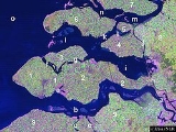
The Oosterschelde is an estuary
in Zeeland
, Netherlands
, between Schouwen-Duiveland
and Tholen
on the north and Noord-Beveland
and Zuid-Beveland
on the south.
During the Roman Era it was the major mouth of the Scheldt
River. Before the St. Felix's Flood
of 1530, it flowed north as a river from the east end of the Westerschelde, turned west a little west of Bergen op Zoom
, and then west along the north edge of what is now the Verdronken Land van Reimerswaal
, and after that widened into an estuary
. Later parts of that lost land were reclaimed, restricting part of the connection to the Scheldt River to a narrow channel called the Kreekrak, which silted up and became unnavigable. In 1903 the Kreekak was closed off with a railway embankment
, connecting in the process the island
of Zuid-Beveland
to the mainland
of North Brabant
. From that moment on, the Oosterschelde lost its connection with the Scheldt, and is no longer functioning as an estuary.
Between Schouwen-Duiveland and Noord-Beveland there are two road connections, the Oosterscheldedam on the west and the Zeeland Bridge
on the east.
After the North Sea flood of 1953
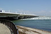
, it was decided to close off the Oosterschelde by means of a dam and barrier. The Oosterscheldekering
(Eastern Scheldt Storm Surge Barrier), between Schouwen-Duiveland and Noord-Beveland, is the largest of 13 ambitious Delta Works
, designed to protect a large part of the Netherlands from flooding. A four kilometre long section has huge sluice-gate-type doors that are normally open, but can be closed under adverse weather conditions.
Upon completion of this barrier in 1986, the flow of water has decreased and the tidal
height differential reduced from 3.4 metres (11.2 ft) to 3.25 metres (10.7 ft). As a result, no new sand is deposited on the sand bars which slowly erode, changing the coastal characteristics.
The park consist primarily of the salt waters of the Oosterschelde, but also includes some mud flats, meadows, and shoals. Because of the large variety of sea life, including unique regional species, the park is popular with Scuba divers
. Other activities include sailing, fishing, cycling, and bird watching.
Estuary
An estuary is a partly enclosed coastal body of water with one or more rivers or streams flowing into it, and with a free connection to the open sea....
in Zeeland
Zeeland
Zeeland , also called Zealand in English, is the westernmost province of the Netherlands. The province, located in the south-west of the country, consists of a number of islands and a strip bordering Belgium. Its capital is Middelburg. With a population of about 380,000, its area is about...
, Netherlands
Netherlands
The Netherlands is a constituent country of the Kingdom of the Netherlands, located mainly in North-West Europe and with several islands in the Caribbean. Mainland Netherlands borders the North Sea to the north and west, Belgium to the south, and Germany to the east, and shares maritime borders...
, between Schouwen-Duiveland
Schouwen-Duiveland
Schouwen-Duiveland is a municipality and an island in the southwestern Netherlands.The Brouwersdam is a dam, part of the Delta Works, from Schouwen-Duiveland to Goedereede, the west part of the island of Goeree-Overflakkee in South Holland....
and Tholen
Tholen
Tholen is a municipality in the southwest of the Netherlands. The municipality of Tholen has lent its name from the town of Tholen, which is the largest population center in the municipality....
on the north and Noord-Beveland
Noord-Beveland
Noord-Beveland is a municipality in the southwestern Netherlands and a former island, now part of the Walcheren-Zuid-Beveland-Noord-Beveland peninsula....
and Zuid-Beveland
Zuid-Beveland
Zuid-Beveland is a part of the province of Zeeland in the Netherlands north of the Westerschelde and south of the Oosterschelde. It is a former island, now peninsula, crossed by the Canal through Zuid-Beveland on the west and the Scheldt-Rhine Canal on the east.It consists of four...
on the south.
During the Roman Era it was the major mouth of the Scheldt
Scheldt
The Scheldt is a 350 km long river in northern France, western Belgium and the southwestern part of the Netherlands...
River. Before the St. Felix's Flood
St. Felix's Flood
The St. Felix's Flood happened on Saturday 5 November 1530, the name day of St. Felix. This day was later known as Evil Saturday . Large parts of Flanders and Zeeland were washed away, including the Verdronken Land van Reimerswaal. According to Audrey M...
of 1530, it flowed north as a river from the east end of the Westerschelde, turned west a little west of Bergen op Zoom
Bergen op Zoom
Bergen op Zoom is a municipality and a city located in the south of the Netherlands.-History:Bergen op Zoom was granted city status probably in 1266. In 1287 the city and its surroundings became a lordship as it was separated from the lordship of Breda. The lordship was elevated to a margraviate...
, and then west along the north edge of what is now the Verdronken Land van Reimerswaal
Verdronken Land van Reimerswaal
The Verdronken Land van Reimerswaal is an area of flood-covered land in Zeeland in the Netherlands between Noord Beveland and Bergen op Zoom. Some of it was lost in the St. Felix's Flood in 1530, and some of it in 1532. The Oosterschelde formerly flowed along its east and north edges...
, and after that widened into an estuary
Estuary
An estuary is a partly enclosed coastal body of water with one or more rivers or streams flowing into it, and with a free connection to the open sea....
. Later parts of that lost land were reclaimed, restricting part of the connection to the Scheldt River to a narrow channel called the Kreekrak, which silted up and became unnavigable. In 1903 the Kreekak was closed off with a railway embankment
Embankment (transportation)
To keep a road or railway line straight or flat, and where the comparative cost or practicality of alternate solutions is prohibitive, the land over which the road or rail line will travel is built up to form an embankment. An embankment is therefore in some sense the opposite of a cutting, and...
, connecting in the process the island
Island
An island or isle is any piece of sub-continental land that is surrounded by water. Very small islands such as emergent land features on atolls can be called islets, cays or keys. An island in a river or lake may be called an eyot , or holm...
of Zuid-Beveland
Zuid-Beveland
Zuid-Beveland is a part of the province of Zeeland in the Netherlands north of the Westerschelde and south of the Oosterschelde. It is a former island, now peninsula, crossed by the Canal through Zuid-Beveland on the west and the Scheldt-Rhine Canal on the east.It consists of four...
to the mainland
Mainland
Mainland is a name given to a large landmass in a region , or to the largest of a group of islands in an archipelago. Sometimes its residents are called "Mainlanders"...
of North Brabant
North Brabant
North Brabant , sometimes called Brabant, is a province of the Netherlands, located in the south of the country, bordered by Belgium in the south, the Meuse River in the north, Limburg in the east and Zeeland in the west.- History :...
. From that moment on, the Oosterschelde lost its connection with the Scheldt, and is no longer functioning as an estuary.
Between Schouwen-Duiveland and Noord-Beveland there are two road connections, the Oosterscheldedam on the west and the Zeeland Bridge
Zeeland Bridge
The Zeeland Bridge is the longest bridge in the Netherlands. The bridge spans the Oosterschelde estuary. It connects the islands of Schouwen-Duiveland and Noord-Beveland in the province of Zeeland....
on the east.
Storm surge barrier and dam
After the North Sea flood of 1953
North Sea flood of 1953
The 1953 North Sea flood was a major flood caused by a heavy storm, that occurred on the night of Saturday 31 January 1953 and morning of 1 February 1953. The floods struck the Netherlands, Belgium, England and Scotland.A combination of a high spring tide and a severe European windstorm caused a...
, it was decided to close off the Oosterschelde by means of a dam and barrier. The Oosterscheldekering
Oosterscheldekering
The Oosterscheldekering , between the islands Schouwen-Duiveland and Noord-Beveland, is the largest of the 13 ambitious Delta works series of dams, designed to protect the Netherlands from flooding...
(Eastern Scheldt Storm Surge Barrier), between Schouwen-Duiveland and Noord-Beveland, is the largest of 13 ambitious Delta Works
Delta Works
The Delta Works is a series of construction projects in the southwest of the Netherlands to protect a large area of land around the Rhine-Meuse-Scheldt delta from the sea. The works consist of dams, sluices, locks, dikes, levees, and storm surge barriers...
, designed to protect a large part of the Netherlands from flooding. A four kilometre long section has huge sluice-gate-type doors that are normally open, but can be closed under adverse weather conditions.
Upon completion of this barrier in 1986, the flow of water has decreased and the tidal
Tide
Tides are the rise and fall of sea levels caused by the combined effects of the gravitational forces exerted by the moon and the sun and the rotation of the Earth....
height differential reduced from 3.4 metres (11.2 ft) to 3.25 metres (10.7 ft). As a result, no new sand is deposited on the sand bars which slowly erode, changing the coastal characteristics.
Oosterschelde National Park
Since May 8, 2002, the entire Oosterschelde was designated a national park. Its boundaries are the dikes of Schouwen-Duiveland, Tholen and Sint-Philipsland, Noord-Beveland and Zuid-Beveland, and the dams of the Delta Works. Having an area of 370 square kilometres (142.9 sq mi), it is the largest national park in the Netherlands. Total shore length is 125 kilometres (77.7 mi).The park consist primarily of the salt waters of the Oosterschelde, but also includes some mud flats, meadows, and shoals. Because of the large variety of sea life, including unique regional species, the park is popular with Scuba divers
Scuba diving
Scuba diving is a form of underwater diving in which a diver uses a scuba set to breathe underwater....
. Other activities include sailing, fishing, cycling, and bird watching.
External links
- Oosterschelde National Park official website
- http://library.thinkquest.org/C001635F/engoosterschelde_kering.htm
- http://www.nioo.knaw.nl/cemo/phase/oosterschelde.htm (see 1st and 2nd map)
- Satellite view, google maps