
One Tree Hill, South Australia
Encyclopedia

Adelaide
Adelaide is the capital city of South Australia and the fifth-largest city in Australia. Adelaide has an estimated population of more than 1.2 million...
, South Australia
South Australia
South Australia is a state of Australia in the southern central part of the country. It covers some of the most arid parts of the continent; with a total land area of , it is the fourth largest of Australia's six states and two territories.South Australia shares borders with all of the mainland...
. It is located in the City of Playford
City of Playford
The City of Playford is a Local Government Area of South Australia, located in Adelaide's northern suburbs. The name 'Playford' comes from the recognition of Sir Thomas Playford, who played a part in the development of the area, and was South Australia's premier from 1938-1965...
.
History
The suburb takes its name from the 'One Tree Hill Inn' (licensed in 1851), for many years the meeting place of the District Council of Munno Para. The inn's name, in turn, referred to a giant red gum tree which stood nearby.. The tree burnt down in 1890 and was cut down in 1934.Aboriginal History
The Kaurna people were the indigenousIndigenous Australians
Indigenous Australians are the original inhabitants of the Australian continent and nearby islands. The Aboriginal Indigenous Australians migrated from the Indian continent around 75,000 to 100,000 years ago....
inhabitants of the Adelaide region, which includes One Tree Hill. The Peramangk
Peramangk
The Peramangk are an Indigenous Australian people whose traditional lands are primarily located in the Adelaide Hills, but also in the southern stretches of the Fleurieu Peninsula, South Australia...
people, living further inland, visited the area from time to time, chiefly in the warmer parts of the year. This was due to the area being cooler and better watered than the plains. The hills at this time were well wooded with tree species that had been in the area for around 6000 years. Along the rivers and creeks and wide valleys could be found tall, heavy eucalypts, many of which had wide, hollowed bases large enough for the Aboriginals to use as shelters. There were many such shelter trees in use by the Kaurna and Peramangk as late as the 1840s, and evidence exists that they hunted and gathered in the woodlands and grasslands for many generations prior to European settlement. Unfortunately, the community declined soon after European settlement, and most of what we know about them today comes from the few artifacts and sparse archaeological evidence that they left behind.
European settlement
Europeans settled the area in the early 1840s, and the township commenced in 1851 with the building of the One Tree Hill Inn. The settlement was located in a strategic location, being close to several larger towns (such as Gawler and Salisbury) with facilities, and became the meeting place of the surrounding rural community, including Gould Creek and Uleybury. A post office and general store were built in 1858 which featured a large cellar where produce including local wine was sold. In 1906, the Institute, which cost about £600, was built across the road from the post office, and became a town meeting place and recreation centre, which was expanded considerably in 1978.One Tree Hill Post Office opened on 19 May 1857.
Demographics
The 2006 Census by the Australian Bureau of StatisticsAustralian Bureau of Statistics
The Australian Bureau of Statistics is Australia's national statistical agency. It was created as the Commonwealth Bureau of Census and Statistics on 8 December 1905, when the Census and Statistics Act 1905 was given Royal assent. It had its beginnings in section 51 of the Constitution of Australia...
counted 1,268 persons in One Tree Hill on census night. Of these, 52.4% were male and 47.6% were female.
The majority of residents (71.2%) are of Australian birth, with 14.8% born in England
England
England is a country that is part of the United Kingdom. It shares land borders with Scotland to the north and Wales to the west; the Irish Sea is to the north west, the Celtic Sea to the south west, with the North Sea to the east and the English Channel to the south separating it from continental...
.
The age distribution of One Tree Hill residents is comparable to that of the greater Australian population. 63.7% of residents were over 25 years in 2006, compared to the Australian average of 66.5%; and 36.3% were younger than 25 years, compared to the Australian average of 33.5%.
Community
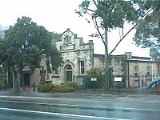
The township has several primary schools (Precolumb School 1855 closed in 1938 when pupils transferred to Uley School 1856 to 1971 (Uleybury School is now a Museum) In 1972 a new school was built on McGilp Road). One Tree Hill has an Institute Hall built 1906 and Uniting Church built 1867 (originally Methodist) and many historic buildings.The township has a small shopping centre and Blacksmiths Inn.Roads
The suburb is serviced by the following main roads:- Black Top Road
- Yorktown Road
- Gawler - One Tree Hill Road
Public transport
The area is not serviced by Adelaide public transport; the nearest service is an Adelaide MetroAdelaide Metro
Adelaide Metro is the public transport system of the South Australian capital of Adelaide and the brand name of the Public Transport Division of the Department of Planning, Transport and Infrastructure. It is an intermodal system with services provided by bus, tram or commuter rail throughout the...
bus route at Craigmore, five kilometres to the west of the town. Until Friday 14 May 1982, a daily bus service ran from the township to Adelaide via Golden Grove and Main North East Road (Route 540E). Before that there was a service to the Smithfield Railway Station. The town centre directly links by road to Elizabeth
Elizabeth, South Australia
Elizabeth is a northern suburb of Adelaide, South Australia. It is located in the City of Playford.-History:Elizabeth was established in 1955 as part of a planned satellite town by the South Australian Housing Trust on rural land between the older towns of Salisbury and...
(Yorktown Road), Golden Grove
Golden Grove, South Australia
Golden Grove is an outer north-eastern suburb of Adelaide, South Australia and is within the City of Tea Tree Gully local government area. It is adjacent to Wynn Vale, Surrey Downs, Greenwith, Yatala Vale, Fairview Park, and Salisbury East.- History :...
(One Tree Hill Road), Salisbury
Salisbury, South Australia
Salisbury is a northern suburb in Adelaide, South Australia. It is the seat of the City of Salisbury, and in the South Australian Legislative Assembly electoral district of Ramsay and the Australian House of Representatives divisions of Wakefield and Port Adelaide...
(Black Top Road), Kersbrook
Kersbrook, South Australia
Kersbrook is a town near Adelaide, South Australia. It is located in the Adelaide Hills Council local government area. At the 2006 census, Kersbrook had a population of 367.-History:...
, Gawler
Gawler, South Australia
Gawler is the first country town in the state of South Australia, and is named after the second Governor of the colony of South Australia, George Gawler. It is located north of the centre of the state capital, Adelaide, and is close to the major wine producing district of the Barossa Valley...
and Williamstown
Williamstown, South Australia
Williamstown is a small South Australian town on the fringe of the Barossa Valley wine-growing region and the Adelaide Hills. It is 51km north east of Adelaide, with an elevation of 310m and an average rainfall of 682.7mm. Williamstown was originally known as Victoria Creek...
. There is no specific provision for bicycles on any of the local roads. There are footpaths on most roads within the town and along Black Top Road in some sections up three kilometres west of the town using land from the old alignment of the road.