

Okutama, Tokyo
Encyclopedia
Towns of Japan
A town is a local administrative unit in Japan. It is a local public body along with prefecture , city , and village...
in Nishitama District
Nishitama, Tokyo
is a district in Tokyo, Japan. It comprises the following three towns and a village:*Hinohara*Hinode*Mizuho*OkutamaHistorically, the cities of Ōme, Fussa, Hamura, and Akiruno were part of Nishitama District but these are now cities and currently broke off from the District after they gained city...
, Tokyo
Tokyo
, ; officially , is one of the 47 prefectures of Japan. Tokyo is the capital of Japan, the center of the Greater Tokyo Area, and the largest metropolitan area of Japan. It is the seat of the Japanese government and the Imperial Palace, and the home of the Japanese Imperial Family...
. As of August 1, 2007, the town had a population of 6712 people, of which 3280 were men and 3432 were women. With an area of 225.63 km², it is the largest community in Tokyo. Mount Kumotori
Mount Kumotori
stands at the boundary of Tokyo, Saitama, and Yamanashi Prefectures on the island of Honshū, Japan. With an elevation of , its summit is the highest point in Tokyo. It separates the Okutama Mountains and the Okuchichibu Mountains...
, Tokyo's highest peak at 2017 m, divides Okutama from the Okuchichibu
Okuchichibu Mountains
or the , is a mountainous district in the Kantō region and Kōshin'etsu region, Japan. It covers the western part of Tokyo, the western part of Saitama Prefecture, the southwestern part of Gunma Prefecture, the southeastern part of Nagano Prefecture, the northern part of Yamanashi Prefecture. Oku ...
region of the neighboring Saitama
Saitama Prefecture
is a prefecture of Japan located in the Kantō region of the island of Honshu. The capital is the city of Saitama.This prefecture is part of the Greater Tokyo Area, and most of Saitama's cities can be described as suburbs of Tokyo, to which a large amount of residents commute each day.- History...
and Yamanashi Prefecture
Yamanashi Prefecture
is a prefecture of Japan located in the Chūbu region of the island of Honshū. The capital is the city of Kōfu.-Pre-history to the 14th century:People have been living in the Yamanashi area for about 30,000 years...
s. Tokyo's northernmost and westernmost points lie in Okutama, as does Lake Okutama
Lake Okutama
is in Tokyo and Yamanashi Prefectures in Japan. Lying above the Ogōchi Dam, it is also known as the Ogōchi Reservoir. The lake occupies part of the town of Okutama in Nishitama District, Tokyo and the village of Tabayama in Kitatsuru District, Yamanashi...
, an important source of water for Tokyo, situated above the Ogōchi Dam in the town.
Prehistory
People began settling in Okutama at least during the Jomon PeriodJomon period
The is the time in Japanese prehistory from about 14,000 BC to 300 BC.The term jōmon means "cord-patterned" in Japanese. This refers to the pottery style characteristic of the Jōmon culture, and which has markings made using sticks with cords wrapped around them...
and many archaeological sites have been found with ancient pottery. During this time period, humans hunted and gathered edible plants. However, during the Yayoi Period
Yayoi period
The is an Iron Age era in the history of Japan traditionally dated 300 BC to 300 AD. It is named after the neighbourhood of Tokyo where archaeologists first uncovered artifacts and features from that era. Distinguishing characteristics of the Yayoi period include the appearance of new...
, humans learned the skill of growing rice, and began moving to the rather flatter lands of present day Okutama. But there is not much evidence for the moving of humans during the Yayoi Period, for 94% of the town was covered by forests and only small flat lands existed.
Edo
During the Edo PeriodEdo period
The , or , is a division of Japanese history which was ruled by the shoguns of the Tokugawa family, running from 1603 to 1868. The political entity of this period was the Tokugawa shogunate....
, the area included in present-day Okutama was divided into 16 villages. In each village, there was one being serving as the mayor, another serving as the leader of a particular group, and another serving as a representative for the farmers. Also, entering Mount Takanosu was forbidden for people of low rank during the Edo Period. This was because the people of high rank (government officials and such) hunted for hawks at the mountain, and the officials wanted to keep the hawks for themselves.
Modern Times
Because of the new system of changing and merging areas into prefectures, the Okutama area (not yet a town) became part of Nirayama Prefecture except for Kotaba village, which was merged into Maebashi Han. Maebashi Han was turned into Maebashi Prefecture in 1871, and then became part of Gunma Prefecture. While Kotaba village was turned into part of Maebashi cityMaebashi, Gunma
is the capital city of Gunma Prefecture, Japan.The city was founded on April 1, 1892, by the samurai Makuba Kawai.On December 5, 2004 the town of Ōgo, and the villages of Kasukawa and Miyagi, all from Seta District, were merged into Maebashi....
, the Okutama area was divided into three villages in 1889, due to a new system of dividing areas into towns and villages. The three villages were called Hikawa, Kori, and Ogouchi. In 1940, Hikawa village was renamed Hikawa town. Then in 1955, Hikawa town, Ogouchi village and Kori village were united, and Okutama town is created.
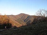
Geography
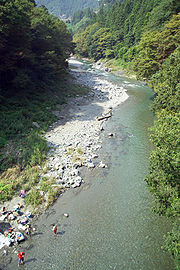
Located in western Tokyo, the town is very mountainous. The largest municipality in Tokyo, Okutama is also known for having the highest mountain in the prefecture, Mount Kumotori, as well. A large portion of the town is covered by forests, and the upstream of the Tama RiverTama River
The is a major river in Yamanashi, Kanagawa and Tokyo Prefectures on Honshū, Japan. It is officially classified as a Class 1 river by the Japanese government....
is located here.
Mountains
- Mount Kumotori
- Mount Kumotori, at 2017 m is the highest mountain in the Kantō regionKanto regionThe is a geographical area of Honshu, the largest island of Japan. The region includes the Greater Tokyo Area and encompasses seven prefectures: Gunma, Tochigi, Ibaraki, Saitama, Tokyo, Chiba, and Kanagawa. Within its boundaries, slightly more than 40 percent of the land area is the Kantō Plain....
. Many plants grow here during the summer, most notably the tsugaTsugaTsuga is a genus of conifers in the family Pinaceae. The common name hemlock is derived from a perceived similarity in the smell of its crushed foliage to that of the unrelated plant poison hemlock....
. From the summit, there is a clear view of Mount FujiMount Fujiis the highest mountain in Japan at . An active stratovolcano that last erupted in 1707–08, Mount Fuji lies about south-west of Tokyo, and can be seen from there on a clear day. Mount Fuji's exceptionally symmetrical cone is a well-known symbol of Japan and it is frequently depicted in art and...
and the Okuchichibu MountainsOkuchichibu Mountainsor the , is a mountainous district in the Kantō region and Kōshin'etsu region, Japan. It covers the western part of Tokyo, the western part of Saitama Prefecture, the southwestern part of Gunma Prefecture, the southeastern part of Nagano Prefecture, the northern part of Yamanashi Prefecture. Oku ...
.
- Mount Kumotori, at 2017 m is the highest mountain in the Kantō region
- Mount Mitō
- Because it was forbidden to enter Mount Mitō during the Edo PeriodEdo periodThe , or , is a division of Japanese history which was ruled by the shoguns of the Tokugawa family, running from 1603 to 1868. The political entity of this period was the Tokugawa shogunate....
, there are still many forests of enormous beechBeechBeech is a genus of ten species of deciduous trees in the family Fagaceae, native to temperate Europe, Asia and North America.-Habit:...
trees. Mount FujiMount Fujiis the highest mountain in Japan at . An active stratovolcano that last erupted in 1707–08, Mount Fuji lies about south-west of Tokyo, and can be seen from there on a clear day. Mount Fuji's exceptionally symmetrical cone is a well-known symbol of Japan and it is frequently depicted in art and...
and Mount Kumotori can be seen from the summit, and it attracts many visitors especially during autumn. It is one of the Three Mountains of Okutama.
- Because it was forbidden to enter Mount Mitō during the Edo Period
- Mount Ōdake
- Mount Ōdake is one of the Three Mountains of Okutama. From the summit at 1266m, Mount FujiMount Fujiis the highest mountain in Japan at . An active stratovolcano that last erupted in 1707–08, Mount Fuji lies about south-west of Tokyo, and can be seen from there on a clear day. Mount Fuji's exceptionally symmetrical cone is a well-known symbol of Japan and it is frequently depicted in art and...
can be seen to the south and Mount Gozen to the west.
- Mount Ōdake is one of the Three Mountains of Okutama. From the summit at 1266m, Mount Fuji
- Mount Kawanori
- From Mount Kawanori, all mountains in Okutama can be seen. Also, the Hyakuhiro Waterfall is located here.
- Mount Gozen
- Mount Gozen is well known for its oddly perfectly triangular shape. Like Mount Mitō, it attracts visitors in the fall.
Rivers
- Tama RiverTama RiverThe is a major river in Yamanashi, Kanagawa and Tokyo Prefectures on Honshū, Japan. It is officially classified as a Class 1 river by the Japanese government....
- The Tama River, with a length of 138 km, is the longest river in the prefecture. It flows through the entire prefecture, and the upstream of the river is located in Okutama.
- Hinohara River
- The Hinohara River is a rather short and small river located in the western portion of TokyoTokyo, ; officially , is one of the 47 prefectures of Japan. Tokyo is the capital of Japan, the center of the Greater Tokyo Area, and the largest metropolitan area of Japan. It is the seat of the Japanese government and the Imperial Palace, and the home of the Japanese Imperial Family...
.
- The Hinohara River is a rather short and small river located in the western portion of Tokyo
Lakes
- Lake OkutamaLake Okutamais in Tokyo and Yamanashi Prefectures in Japan. Lying above the Ogōchi Dam, it is also known as the Ogōchi Reservoir. The lake occupies part of the town of Okutama in Nishitama District, Tokyo and the village of Tabayama in Kitatsuru District, Yamanashi...
- Lake Shiromaru
- Lake Shiromaru is a rather infamous dam on the Tama River. It has a height of 30.3m, a length of 61.0m, and a volume of 14,161m³VolumeVolume is the quantity of three-dimensional space enclosed by some closed boundary, for example, the space that a substance or shape occupies or contains....
.
- Lake Shiromaru is a rather infamous dam on the Tama River. It has a height of 30.3m, a length of 61.0m, and a volume of 14,161m³
Surrounding municipalities
- Tokyo
- ŌmeOme, Tokyois a city located in Tokyo, Japan.As of October 1, 2010, the city has an estimated population of 139,932 and a density of 1,355.14 persons per km². The total area is 103.26 km².The characters 青梅 literally mean blue ume, or Japanese apricot....
- AkirunoAkiruno, Tokyois a city located in the western end of Tokyo Metropolis, Japan. As of 2010, the city has an estimated population of 80,621 and a population density of 1,100 persons per km². The total area was 73.34 km².-Geography:...
- HinoharaHinohara, Tokyois a municipality in Nishitama District, Tokyo, Japan. It is the only administrative unit left in the non-insular area of Tokyo that is still classified as a village...
- Ōme
- Saitama Prefecture
- ChichibuChichibu, Saitamais a city in Saitama, Japan. As of April 1, 2011, the city has an estimated population of 68,701, with a household number of 26,230. The total area is 577.69 km²....
- HannōHanno, Saitamais a city in Saitama Prefecture, Japan.As of April 1, 2011, the city has an estimated population of 82,683 and a population density of 614.29 per km²...
- Chichibu
- Yamanashi Prefecture
- Uenohara
- KosugeKosuge, Yamanashiis a village located in Kitatsuru District, Yamanashi, Japan.As of 2003, the village has an estimated population of 1,041 and a density of 19.77 persons per km². The total area is 52.65 km².-External links:*...
- TabayamaTabayama, Yamanashiis a village located in Kitatsuru District, Yamanashi, Japan.As of 2007, the village has an estimated population of 740 and a density of 7.3 persons per km². The total area is 101.55 km².-Geography:...
Rail
The East Japan Railway Company serves the town. The Ōme line, which connects the town with Tachikawa, terminates at Okutama Station.- East Japan Railway CompanyEast Japan Railway Companyis the largest passenger railway company in the world and one of the seven Japan Railways Group companies. The company name is officially abbreviated as JR East in English, and as in Japanese. The company's headquarters are in Yoyogi, Shibuya, Tokyo....
(JR East)- Ōme LineOme LineThe is a railway line operated by East Japan Railway Company in western Tokyo, Japan. It links Tachikawa and the Chūō Line with the town of Okutama. Many Chūō Line trains operate via the Ōme Line to Ōme Station, providing non-stop service to Tokyo Station....
- Kawai StationKawai Station (Tokyo)is a train station in Okutama, Nishitama District, Tokyo, Japan.- Adjacent stations :...
, Kori StationKori Stationis a train station in Okutama, Nishitama District, Tokyo, Japan.- Adjacent stations :...
, Hatonosu StationHatonosu Stationis a train station in Okutama, Nishitama District, Tokyo, Japan.- Adjacent stations :...
, Shiromaru StationShiromaru Stationis a train station in Okutama, Nishitama District, Tokyo, Japan.- Adjacent stations :...
, Okutama Station
- Kawai Station
- Ōme Line
Bus
The Nishi Tokyo Bus Co.Nishi Tokyo Bus
is a bus-operating company in western Tama Area, mainly in Hachioji and Akiruno, Tokyo, Japan. It has in a subsidiary which once took charge of bus routes in western Hachioji area and Ome area, and expressway bus routes. Although it now belongs to Keio Group, it was originally a bus section of Ome...
carries passengers to Lake Okutama, the Nippara Limestone Cave, Tabayama village and Kosuge village (both in Yamanashi Prefecture) from Okutama Station.
Road
- National HighwaysNational highways of JapanJapan has a nationwide system of distinct from the expressways. The Ministry of Land, Infrastructure and Transport and other government agencies administer the national highways. Beginning in 1952, Japan classified these as Class 1 or Class 2. Class 1 highways had one- or two-digit numbers, while...
- Highway 139
- Highway 411
- Prefectural RoadsPrefectural roadA in Japan is a road numbered by the prefecture, independent of other prefectures.- See also:* National highways of Japan* Expressways of Japan*...
- Tokyo Prefectural Road 184 Okutama-Akiruno
- Tokyo Prefectural Road 204 Nippara Limestone Cave
- Tokyo Prefectural Road 205
- Tokyo Prefectural Road 206 Kawano-Kamikawa
Education
There are two primary schools and two junior high schools in Okutama, all named after the former villages of Kori and Kōrikawa.- Junior High Schools
- Kōrikawa Intermediate School
- Kori Intermediate School
- Primary Schools
- Kōrikawa Elementary School
- Kori Elementary School
Tokyo Metropolitan Government Board of Education
Tokyo Metropolitan Government Board of Education
The Tokyo Metropolitan Government Board of Education is the board of education in Tokyo, Japan. The board manages the individual school systems within the metropolis. The board also directly manages all of the public high schools in Tokyo...
operates Mizuho High School http://www.mizuho-h.metro.tokyo.jp/ in nearby Mizuho
Mizuho, Tokyo
is a town in Nishitama District, Tokyo, Japan. It was established on November 10, 1940, resulting from the merger of four villages and acquired additional land in 1958....
.
The school district
School district
School districts are a form of special-purpose district which serves to operate the local public primary and secondary schools.-United States:...
operates the following high schools in Akiruno
Akiruno, Tokyo
is a city located in the western end of Tokyo Metropolis, Japan. As of 2010, the city has an estimated population of 80,621 and a population density of 1,100 persons per km². The total area was 73.34 km².-Geography:...
:
- Akirudai High School http://www.akiru-h.metro.tokyo.jp/
- Itsukaichi High School http://www.itsukaichi-h.metro.tokyo.jp/
The school district operates the following high schools in Ōme
Ome, Tokyo
is a city located in Tokyo, Japan.As of October 1, 2010, the city has an estimated population of 139,932 and a density of 1,355.14 persons per km². The total area is 103.26 km².The characters 青梅 literally mean blue ume, or Japanese apricot....
:
- Norin High School http://www.norin-h.metro.tokyo.jp/
- Ome Sogo High School http://www.ome-sogo-h.metro.tokyo.jp/
- Tama High School http://www.tama-h.metro.tokyo.jp/
Notable places

- Lake Okutama
- Lake Okutama plays a major role in providing drinking water for the people of Tokyo. The largest lake in Tokyo, it also has a large dam.
- Mount Takanosu
- During the Edo Period, the people of low rank were forbidden to enter Mount Takanosu, because it was a hawk hunting ground for the government and military officials. Now, it is open to hikers, and has an elevation of 1736.6m.
- Tsurunoyu Onsen
- Until the construction of Ogouchi Dam, there was a spa townSpa townA spa town is a town situated around a mineral spa . Patrons resorted to spas to "take the waters" for their purported health benefits. The word comes from the Belgian town Spa. In continental Europe a spa was known as a ville d'eau...
for Tsurunoyu Onsen. (It is now at in the depths of the dam.) Now, there are a few inns that use the hot water from the hot spring for their spas. The hot spring is located about 20 minutes by bus from Okutama Station.
- Until the construction of Ogouchi Dam, there was a spa town
- Hyakuhiro Waterfall
-
- Hyakuhiro Waterfall, with a height of 40m, is a famous waterfall in the Okutama area. Located in Mount Kawanori, it is part of the Nippara River.
- Nippara Cave
- Nippara Cave is the largest limestone cave in the Kantō regionKanto regionThe is a geographical area of Honshu, the largest island of Japan. The region includes the Greater Tokyo Area and encompasses seven prefectures: Gunma, Tochigi, Ibaraki, Saitama, Tokyo, Chiba, and Kanagawa. Within its boundaries, slightly more than 40 percent of the land area is the Kantō Plain....
, and attracts many visitors from around Japan.
- Nippara Cave is the largest limestone cave in the Kantō region
- Okuchichibu Mountains
- The Okuchichibu Mountains stretch from NaganoNagano Prefectureis a prefecture of Japan located in the Chūbu region of the island of Honshū. The capital is the city of Nagano.- History :Nagano was formerly known as the province of Shinano...
's Nobeyama region to Okutama and a portion of Saitama Prefecture and Yamanashi Prefecture. The highest mountain is Mount Kurogane (Yamanashi Prefecture), at 2232m, and the lowest is Mount AzumayaMount Azumayais one of the 100 Famous Japanese Mountains. The high peak lies, on the border of Nagano Prefecture and Gunma Prefecture. There exist alternative spellings of the mountain's name, like: 吾妻山 and 吾嬬山 which is read as "Agatsumayama"...
(Saitama Prefecture), at 772m.
- The Okuchichibu Mountains stretch from Nagano
- Okutama Onsen
- Okutama Onsen is a hot spring located in the town.