

Offa's Dyke Path
Encyclopedia
Offa's Dyke Path is a long distance footpath along the Welsh
-English
border. Opened in 1971, it is one of Britain's premier National Trails and draws walkers
from throughout the world. Much of the 283 km (175.8 mi) long route either follows, or keeps close company with, the remnants of Offa's Dyke
, an 8th century earthwork
, the majority of which was probably constructed on the orders of Mercia
n King Offa
.
 Most walkers travel south to north, starting by the Severn Estuary
, at Sedbury
, near Chepstow
, and finishing at Prestatyn
on the north coast. The walk will take an average walker roughly 12 days to complete, although this can vary depending on individual fitness, attitude, the weather, age and experience.
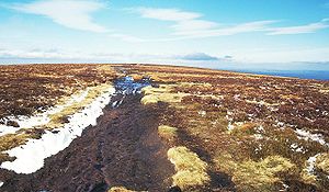
Following a man-made border and ancient monument, rather than natural features, the dyke crosses a variety of different landscapes. The route crosses the Black Mountains
, the Shropshire
hills (including the many ups and downs of the 'Switchback', for many walkers the hardest part of the walk), the Eglwyseg
mountains near Llangollen
, and the Clwydian Range
.
It passes through, or close to, the towns of Chepstow
, Monmouth
, Abergavenny
, Hay-on-Wye
, Kington
, Knighton, Montgomery and then in and around the North Wales
towns and villages of Llangollen
, Llandegla
, Clwyd Gate, Bodfari
and Dyserth
.
The half-way point of the walk is marked by the Offa's Dyke Centre in Knighton
Wales
Wales is a country that is part of the United Kingdom and the island of Great Britain, bordered by England to its east and the Atlantic Ocean and Irish Sea to its west. It has a population of three million, and a total area of 20,779 km²...
-English
England
England is a country that is part of the United Kingdom. It shares land borders with Scotland to the north and Wales to the west; the Irish Sea is to the north west, the Celtic Sea to the south west, with the North Sea to the east and the English Channel to the south separating it from continental...
border. Opened in 1971, it is one of Britain's premier National Trails and draws walkers
Hillwalking
In the British Isles, the terms hillwalking or fellwalking are commonly used to describe the recreational outdoor activity of walking on hills and mountains, often with the intention of visiting their summits...
from throughout the world. Much of the 283 km (175.8 mi) long route either follows, or keeps close company with, the remnants of Offa's Dyke
Offa's Dyke
Offa's Dyke is a massive linear earthwork, roughly followed by some of the current border between England and Wales. In places, it is up to wide and high. In the 8th century it formed some kind of delineation between the Anglian kingdom of Mercia and the Welsh kingdom of Powys...
, an 8th century earthwork
Earthworks (engineering)
Earthworks are engineering works created through the moving or processing of quantities of soil or unformed rock.- Civil engineering use :Typical earthworks include roads, railway beds, causeways, dams, levees, canals, and berms...
, the majority of which was probably constructed on the orders of Mercia
Mercia
Mercia was one of the kingdoms of the Anglo-Saxon Heptarchy. It was centred on the valley of the River Trent and its tributaries in the region now known as the English Midlands...
n King Offa
Offa of Mercia
Offa was the King of Mercia from 757 until his death in July 796. The son of Thingfrith and a descendant of Eowa, Offa came to the throne after a period of civil war following the assassination of Æthelbald after defeating the other claimant Beornred. In the early years of Offa's reign it is likely...
.
Walking
Severn Estuary
The Severn Estuary is the estuary of the River Severn, the longest river in Great Britain. Its high tidal range means it has been at the centre of discussions in the UK regarding renewable energy.-Geography:...
, at Sedbury
Sedbury
Sedbury is a village in the Forest of Dean district of west Gloucestershire, England. It is located on the eastern bank of the River Wye, facing the Welsh town of Chepstow...
, near Chepstow
Chepstow
Chepstow is a town in Monmouthshire, Wales, adjoining the border with Gloucestershire, England. It is located on the River Wye, close to its confluence with the River Severn, and close to the western end of the Severn Bridge on the M48 motorway...
, and finishing at Prestatyn
Prestatyn
Prestatyn is a seaside resort, town and community in Denbighshire, North Wales. It is located on the Irish Sea coast, to the east of Rhyl. At the 2001 Census, Prestatyn had a population of 18,496.-Prehistory:...
on the north coast. The walk will take an average walker roughly 12 days to complete, although this can vary depending on individual fitness, attitude, the weather, age and experience.
Following a man-made border and ancient monument, rather than natural features, the dyke crosses a variety of different landscapes. The route crosses the Black Mountains
Black Mountains, Wales
The Black Mountains are a group of hills spread across parts of Powys and Monmouthshire in southeast Wales, and extending across the national border into Herefordshire, England. They are the easternmost of the four ranges of hills that comprise the Brecon Beacons National Park, and are frequently...
, the Shropshire
Shropshire
Shropshire is a county in the West Midlands region of England. For Eurostat purposes, the county is a NUTS 3 region and is one of four counties or unitary districts that comprise the "Shropshire and Staffordshire" NUTS 2 region. It borders Wales to the west...
hills (including the many ups and downs of the 'Switchback', for many walkers the hardest part of the walk), the Eglwyseg
Eglwyseg
The Eglwyseg valley is an area to the north east of Llangollen in Denbighshire, Wales; it is within the boundaries of Llantysilio Community. The name also refers to a widely-scattered hamlet in the valley....
mountains near Llangollen
Llangollen
Llangollen is a small town and community in Denbighshire, north-east Wales, situated on the River Dee and on the edge of the Berwyn mountains. It has a population of 3,412.-History:...
, and the Clwydian Range
Clwydian Range
The Clwydian Range is a series of hills and mountains in north east Wales that runs from Llandegla in the south to Prestatyn in the north, with the highest point being the popular Moel Famau...
.
It passes through, or close to, the towns of Chepstow
Chepstow
Chepstow is a town in Monmouthshire, Wales, adjoining the border with Gloucestershire, England. It is located on the River Wye, close to its confluence with the River Severn, and close to the western end of the Severn Bridge on the M48 motorway...
, Monmouth
Monmouth
Monmouth is a town in southeast Wales and traditional county town of the historic county of Monmouthshire. It is situated close to the border with England, where the River Monnow meets the River Wye with bridges over both....
, Abergavenny
Abergavenny
Abergavenny , meaning Mouth of the River Gavenny, is a market town in Monmouthshire, Wales. It is located 15 miles west of Monmouth on the A40 and A465 roads, 6 miles from the English border. Originally the site of a Roman fort, Gobannium, it became a medieval walled town within the Welsh Marches...
, Hay-on-Wye
Hay-on-Wye
Hay-on-Wye , often described as "the town of books", is a small market town and community in Powys, Wales.-Location:The town lies on the east bank of the River Wye and is within the Brecon Beacons National Park, just north of the Black Mountains...
, Kington
Kington, Herefordshire
Kington is a market town and civil parish in Herefordshire, England. According to the 2001 census it had a population of 2,597.-Location:Kington is near the Wales-England border and, despite being on the western side of Offa's Dyke, has been English for over a thousand years. The town is in the...
, Knighton, Montgomery and then in and around the North Wales
North Wales
North Wales is the northernmost unofficial region of Wales. It is bordered to the south by the counties of Ceredigion and Powys in Mid Wales and to the east by the counties of Shropshire in the West Midlands and Cheshire in North West England...
towns and villages of Llangollen
Llangollen
Llangollen is a small town and community in Denbighshire, north-east Wales, situated on the River Dee and on the edge of the Berwyn mountains. It has a population of 3,412.-History:...
, Llandegla
Llandegla
Llandegla or Llandegla-yn-Iâl is a village and community in the county of Denbighshire in Wales. In the 2001 census, the community had a population of 494.- Name :...
, Clwyd Gate, Bodfari
Bodfari
Bodfari is a village in Denbighshire, Wales.- Location :Bodfari is located at approximate grid reference SJ093701. The village lies on the A541 road at the point where the road passes through a gap in the Clwydian Hills, the gap being part of the valley of the River Wheeler .The Offa's Dyke...
and Dyserth
Dyserth
Dyserth is a village in Denbighshire, Wales. Population : 2,566 . Its main features are the extensive quarrying remains, its waterfalls, railway line , and mountain ....
.
The half-way point of the walk is marked by the Offa's Dyke Centre in Knighton