

Nuclear-Weapon-Free Zone
Encyclopedia
United Nations
The United Nations is an international organization whose stated aims are facilitating cooperation in international law, international security, economic development, social progress, human rights, and achievement of world peace...
as an agreement which a group of states has freely established by treaty or convention, that bans the use, development, or deployment of nuclear weapons in a given area, that has mechanisms of verification and control to enforce its obligations, and that is recognized as such by the General Assembly of the United Nations.
NWFZs do not cover international waters
International waters
The terms international waters or trans-boundary waters apply where any of the following types of bodies of water transcend international boundaries: oceans, large marine ecosystems, enclosed or semi-enclosed regional seas and estuaries, rivers, lakes, groundwater systems , and wetlands.Oceans,...
(where there is freedom of the seas
Freedom of the seas
Freedom of the seas is a principle in the international law and law of the sea. It stresses freedom to navigate the oceans. It also disapproves of war fought in water. The freedom is to be breached only in a necessary international agreement....
) or transit of nuclear missiles through space (as opposed to deployment of nuclear weapons in space
Outer Space Treaty
The Outer Space Treaty, formally the Treaty on Principles Governing the Activities of States in the Exploration and Use of Outer Space, including the Moon and Other Celestial Bodies, is a treaty that forms the basis of international space law...
).
The NWFZ definition does not count countries or smaller regions that have outlawed nuclear weapons simply by their own law, like Austria
Austria
Austria , officially the Republic of Austria , is a landlocked country of roughly 8.4 million people in Central Europe. It is bordered by the Czech Republic and Germany to the north, Slovakia and Hungary to the east, Slovenia and Italy to the south, and Switzerland and Liechtenstein to the...
with the Atomsperrgesetz in 1999; also, the 2+4 Treaty, at the end of the Cold War
Cold War
The Cold War was the continuing state from roughly 1946 to 1991 of political conflict, military tension, proxy wars, and economic competition between the Communist World—primarily the Soviet Union and its satellite states and allies—and the powers of the Western world, primarily the United States...
, banned nuclear weapons in the six states, which joined to Germany 1990 (area of Berlin
Berlin
Berlin is the capital city of Germany and is one of the 16 states of Germany. With a population of 3.45 million people, Berlin is Germany's largest city. It is the second most populous city proper and the seventh most populous urban area in the European Union...
and former East Germany), but was an agreement only among the four Allies and two German states.
NWFZs have a similar purpose to, but are distinct from, the Nuclear Non-Proliferation Treaty
Nuclear Non-Proliferation Treaty
The Treaty on the Non-Proliferation of Nuclear Weapons, commonly known as the Non-Proliferation Treaty or NPT, is a landmark international treaty whose objective is to prevent the spread of nuclear weapons and weapons technology, to promote cooperation in the peaceful uses of nuclear energy and to...
to which all countries except for four nuclear weapons states are party. Another term, nuclear-free zone
Nuclear-free zone
A nuclear-free zone is an area where nuclear weapons and nuclear power are banned. The specific ramifications of these depend on the locale in question....
, often means an area which has banned both nuclear power and nuclear weapons, and usually does not mean a UN-acknowledged international treaty.
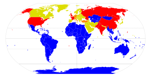
Coverage of Earth
Today there are five zones covering continental or subcontinental groups of countries (including their territorial waters and airspace), one UN-recognized zone consisting of a single country, Mongolia, and three governing Antarctica, the seabed, and outer space which are not part of any state. The Antarctic, seabed, and space zones preceded all but one of the zones on national territories. Most of the Earth's oceanOcean
An ocean is a major body of saline water, and a principal component of the hydrosphere. Approximately 71% of the Earth's surface is covered by ocean, a continuous body of water that is customarily divided into several principal oceans and smaller seas.More than half of this area is over 3,000...
s above the seabed are not covered by NWFZs since freedom of the seas
Freedom of the seas
Freedom of the seas is a principle in the international law and law of the sea. It stresses freedom to navigate the oceans. It also disapproves of war fought in water. The freedom is to be breached only in a necessary international agreement....
restricts restrictions in international waters
International waters
The terms international waters or trans-boundary waters apply where any of the following types of bodies of water transcend international boundaries: oceans, large marine ecosystems, enclosed or semi-enclosed regional seas and estuaries, rivers, lakes, groundwater systems , and wetlands.Oceans,...
.
when the African NWFZ came into force, the six land zones cover 56% of the Earth's land area of 149 million square kilometers and 60% of the 193 states on Earth, up from 34% and 30% the previous year; however only 39% of the world's population lives in NWFZs, while the nine nuclear weapons states have 28% of world land area area and 46% of world population.
Boundaries
The Antarctic, Latin American, and South Pacific zones are defined by lines of latitudeLatitude
In geography, the latitude of a location on the Earth is the angular distance of that location south or north of the Equator. The latitude is an angle, and is usually measured in degrees . The equator has a latitude of 0°, the North pole has a latitude of 90° north , and the South pole has a...
and longitude
Longitude
Longitude is a geographic coordinate that specifies the east-west position of a point on the Earth's surface. It is an angular measurement, usually expressed in degrees, minutes and seconds, and denoted by the Greek letter lambda ....
, except for the northwestern boundary of the South Pacific zone which follows the limit of Australian territorial waters, and these three zones form a contiguous area, though treaty provisions do not apply to international waters
International waters
The terms international waters or trans-boundary waters apply where any of the following types of bodies of water transcend international boundaries: oceans, large marine ecosystems, enclosed or semi-enclosed regional seas and estuaries, rivers, lakes, groundwater systems , and wetlands.Oceans,...
within that area. In contrast, the Southeast Asian zone is defined as the territories of its members including their Exclusive Economic Zone
Exclusive Economic Zone
Under the law of the sea, an exclusive economic zone is a seazone over which a state has special rights over the exploration and use of marine resources, including production of energy from water and wind. It stretches from the seaward edge of the state's territorial sea out to 200 nautical...
s, and the African zone is also defined as the countries and territories considered part of Africa by the OAU (now the African Union
African Union
The African Union is a union consisting of 54 African states. The only all-African state not in the AU is Morocco. Established on 9 July 2002, the AU was formed as a successor to the Organisation of African Unity...
) which include islands close to Africa and Madagascar
Madagascar
The Republic of Madagascar is an island country located in the Indian Ocean off the southeastern coast of Africa...
. An AU member, Mauritius
Mauritius
Mauritius , officially the Republic of Mauritius is an island nation off the southeast coast of the African continent in the southwest Indian Ocean, about east of Madagascar...
, claims the British Indian Ocean Territory
British Indian Ocean Territory
The British Indian Ocean Territory or Chagos Islands is an overseas territory of the United Kingdom situated in the Indian Ocean, halfway between Africa and Indonesia...
where Diego Garcia
Diego Garcia
Diego Garcia is a tropical, footprint-shaped coral atoll located south of the equator in the central Indian Ocean at 7 degrees, 26 minutes south latitude. It is part of the British Indian Ocean Territory [BIOT] and is positioned at 72°23' east longitude....
is currently a US military base
Military base
A military base is a facility directly owned and operated by or for the military or one of its branches that shelters military equipment and personnel, and facilitates training and operations. In general, a military base provides accommodations for one or more units, but it may also be used as a...
.
Nuclear weapons states' territories within NWFZs
| Treaty | Britain | France | U.S. |
|---|---|---|---|
| Tlatelolco Treaty of Tlatelolco The Treaty of Tlatelolco is the conventional name given to the Treaty for the Prohibition of Nuclear Weapons in Latin America and the Caribbean... |
Anguilla Anguilla Anguilla is a British overseas territory and overseas territory of the European Union in the Caribbean. It is one of the most northerly of the Leeward Islands in the Lesser Antilles, lying east of Puerto Rico and the Virgin Islands and directly north of Saint Martin... , Virgin Islands British Virgin Islands The Virgin Islands, often called the British Virgin Islands , is a British overseas territory and overseas territory of the European Union, located in the Caribbean to the east of Puerto Rico. The islands make up part of the Virgin Islands archipelago, the remaining islands constituting the U.S... Caymans, Turks & Caicos Falklands, South Georgia |
French Guiana French Guiana French Guiana is an overseas region of France, consisting of a single overseas department located on the northern Atlantic coast of South America. It has borders with two nations, Brazil to the east and south, and Suriname to the west... Guadeloupe Guadeloupe Guadeloupe is an archipelago located in the Leeward Islands, in the Lesser Antilles, with a land area of 1,628 square kilometres and a population of 400,000. It is the first overseas region of France, consisting of a single overseas department. As with the other overseas departments, Guadeloupe... , Martinique Martinique Martinique is an island in the eastern Caribbean Sea, with a land area of . Like Guadeloupe, it is an overseas region of France, consisting of a single overseas department. To the northwest lies Dominica, to the south St Lucia, and to the southeast Barbados... St Barthélemy Saint Barthélemy Saint Barthélemy , officially the Territorial collectivity of Saint Barthélemy , is an overseas collectivity of France. Often abbreviated to Saint-Barth in French, or St. Barts in English, the indigenous people called the island Ouanalao... , St Martin Saint Martin Saint Martin is an island in the northeast Caribbean, approximately east of Puerto Rico. The 87 km2 island is divided roughly 60/40 between France and the Kingdom of the Netherlands ; however, the Dutch side has the larger population. It is one of the smallest sea islands divided between... |
Puerto Rico Puerto Rico Puerto Rico , officially the Commonwealth of Puerto Rico , is an unincorporated territory of the United States, located in the northeastern Caribbean, east of the Dominican Republic and west of both the United States Virgin Islands and the British Virgin Islands.Puerto Rico comprises an... Virgin Islands USMOI |
| Rarotonga Treaty of Rarotonga The Treaty of Rarotonga is the common name for the South Pacific Nuclear Free Zone Treaty, which formalizes a nuclear-weapon-free zone in the South Pacific... |
Pitcairn Island | Fr. Polynesia French Polynesia French Polynesia is an overseas country of the French Republic . It is made up of several groups of Polynesian islands, the most famous island being Tahiti in the Society Islands group, which is also the most populous island and the seat of the capital of the territory... , New Caledonia New Caledonia New Caledonia is a special collectivity of France located in the southwest Pacific Ocean, east of Australia and about from Metropolitan France. The archipelago, part of the Melanesia subregion, includes the main island of Grande Terre, the Loyalty Islands, the Belep archipelago, the Isle of... Wallis & Futuna Wallis and Futuna Wallis and Futuna, officially the Territory of the Wallis and Futuna Islands , is a Polynesian French island territory in the South Pacific between Tuvalu to the northwest, Rotuma of Fiji to the west, the main part of Fiji to the southwest, Tonga to the southeast,... |
Am. Samoa American Samoa American Samoa is an unincorporated territory of the United States located in the South Pacific Ocean, southeast of the sovereign state of Samoa... |
| Pelindaba | Br. Indian Ocean Territory British Indian Ocean Territory The British Indian Ocean Territory or Chagos Islands is an overseas territory of the United Kingdom situated in the Indian Ocean, halfway between Africa and Indonesia... |
Réunion Réunion Réunion is a French island with a population of about 800,000 located in the Indian Ocean, east of Madagascar, about south west of Mauritius, the nearest island.Administratively, Réunion is one of the overseas departments of France... , Mayotte Mayotte Mayotte is an overseas department and region of France consisting of a main island, Grande-Terre , a smaller island, Petite-Terre , and several islets around these two. The archipelago is located in the northern Mozambique Channel in the Indian Ocean, namely between northwestern Madagascar and... , Îles Éparses Scattered islands in the Indian Ocean The Scattered Islands in the Indian Ocean consist of four small coral islands, an atoll, and a reef in the Indian Ocean, and have constituted the 5th district of the French Southern and Antarctic Lands since February 2007. They have no permanent population... |
NWFZs do cover most territories belonging to nuclear weapons states that are situated inside NWFZ boundaries; all are small islands except for French Guiana
French Guiana
French Guiana is an overseas region of France, consisting of a single overseas department located on the northern Atlantic coast of South America. It has borders with two nations, Brazil to the east and south, and Suriname to the west...
. However, the U.S. signed but has not ratified Protocol I to the Treaty of Rarotonga which would apply to American Samoa
American Samoa
American Samoa is an unincorporated territory of the United States located in the South Pacific Ocean, southeast of the sovereign state of Samoa...
and the U.S. and Britain dispute the African NWFZ's applicability to Diego Garcia
Diego Garcia
Diego Garcia is a tropical, footprint-shaped coral atoll located south of the equator in the central Indian Ocean at 7 degrees, 26 minutes south latitude. It is part of the British Indian Ocean Territory [BIOT] and is positioned at 72°23' east longitude....
which is an American military base.
Countries without nuclear weapons or NWFZ
All countries without nuclear weapons are parties to the Non-Proliferation Treaty, as are the 5 NPT-sanctioned nuclear weapon states.Proposals for additional NWFZs
There have been NWFZ proposals for the Middle EastMiddle East
The Middle East is a region that encompasses Western Asia and Northern Africa. It is often used as a synonym for Near East, in opposition to Far East...
(e.g. Nuclear program of Iran#Nuclear Free Zone in the Mideast, 2009 UN proposal, 2011 IAEA forum), the Korean Peninsula
Korean Peninsula
The Korean Peninsula is a peninsula in East Asia. It extends southwards for about 684 miles from continental Asia into the Pacific Ocean and is surrounded by the Sea of Japan to the south, and the Yellow Sea to the west, the Korea Strait connecting the first two bodies of water.Until the end of...
, Central Europe
Central Europe
Central Europe or alternatively Middle Europe is a region of the European continent lying between the variously defined areas of Eastern and Western Europe...
, South Asia
South Asia
South Asia, also known as Southern Asia, is the southern region of the Asian continent, which comprises the sub-Himalayan countries and, for some authorities , also includes the adjoining countries to the west and the east...
, and the Arctic
Arctic
The Arctic is a region located at the northern-most part of the Earth. The Arctic consists of the Arctic Ocean and parts of Canada, Russia, Greenland, the United States, Norway, Sweden, Finland, and Iceland. The Arctic region consists of a vast, ice-covered ocean, surrounded by treeless permafrost...
.
Collective security alliances
The majority of non-NWS non-NWFZ states are members of (or geographically protected by) collective securityCollective security
Collective security can be understood as a security arrangement, regional or global, in which each state in the system accepts that the security of one is the concern of all, and agrees to join in a collective response to threats to, and breaches of, the peace...
alliances with Western powers:
- NATO members (25) share nuclear umbrellaNuclear umbrellaNuclear umbrella refers to a guarantee by a nuclear weapons state to defend a non-nuclear allied state.It is usually used for the security alliances of the United States with Japan, South Korea, the North Atlantic Treaty Organization , and Australia, originating with the Cold War with the Soviet...
with Britain, France, and the USA - Other European UnionEuropean UnionThe European Union is an economic and political union of 27 independent member states which are located primarily in Europe. The EU traces its origins from the European Coal and Steel Community and the European Economic Community , formed by six countries in 1958...
states (Austria, Ireland, Sweden, Finland) are part of the EU's Common Security and Defence Policy - States surrounded by NATO and EU (Switzerland, LiechtensteinLiechtensteinThe Principality of Liechtenstein is a doubly landlocked alpine country in Central Europe, bordered by Switzerland to the west and south and by Austria to the east. Its area is just over , and it has an estimated population of 35,000. Its capital is Vaduz. The biggest town is Schaan...
, San Marino, Vatican, Andorra, Bosnia, Montenegro, Macedonia, Serbia and Kosovo).
The above categories cover all European countries west of the former Soviet Union as well as the Baltic states
Baltic states
The term Baltic states refers to the Baltic territories which gained independence from the Russian Empire in the wake of World War I: primarily the contiguous trio of Estonia, Latvia, Lithuania ; Finland also fell within the scope of the term after initially gaining independence in the 1920s.The...
, Turkey
Turkey
Turkey , known officially as the Republic of Turkey , is a Eurasian country located in Western Asia and in East Thrace in Southeastern Europe...
, and Canada
Canada
Canada is a North American country consisting of ten provinces and three territories. Located in the northern part of the continent, it extends from the Atlantic Ocean in the east to the Pacific Ocean in the west, and northward into the Arctic Ocean...
.
- South KoreaSouth KoreaThe Republic of Korea , , is a sovereign state in East Asia, located on the southern portion of the Korean Peninsula. It is neighbored by the People's Republic of China to the west, Japan to the east, North Korea to the north, and the East China Sea and Republic of China to the south...
and JapanJapanJapan is an island nation in East Asia. Located in the Pacific Ocean, it lies to the east of the Sea of Japan, China, North Korea, South Korea and Russia, stretching from the Sea of Okhotsk in the north to the East China Sea and Taiwan in the south...
are American allies under its nuclear umbrella. - MarshallsMarshallsMarshalls, Inc., is a chain of American department stores owned by TJX Companies. Marshalls has over 750 conventional stores, as well as larger stores named Marshalls Mega Store, covering 42 states and Puerto Rico. Marshalls expanded into Canada in March 2011...
, Federated States of MicronesiaFederated States of MicronesiaThe Federated States of Micronesia or FSM is an independent, sovereign island nation, made up of four states from west to east: Yap, Chuuk, Pohnpei and Kosrae. It comprises approximately 607 islands with c...
, and PalauPalauPalau , officially the Republic of Palau , is an island nation in the Pacific Ocean, east of the Philippines and south of Tokyo. In 1978, after three decades as being part of the United Nations trusteeship, Palau chose independence instead of becoming part of the Federated States of Micronesia, a...
are in Compact of Free AssociationCompact of Free AssociationThe Compact of Free Association defines the relationship that three sovereign states—the Federated States of Micronesia , the Republic of the Marshall Islands and the Republic of Palau—have entered into as associated states with the United States.Now sovereign nations, the three freely associated...
with the USA
Other Eurasian states
24 other Eurasian countries do not have nuclear weapons or an NWFZ:- 6 post-Soviet statesPost-Soviet statesThe post-Soviet states, also commonly known as the Former Soviet Union or former Soviet republics, are the 15 independent states that split off from the Union of Soviet Socialist Republics in its dissolution in December 1991...
: BelarusBelarusBelarus , officially the Republic of Belarus, is a landlocked country in Eastern Europe, bordered clockwise by Russia to the northeast, Ukraine to the south, Poland to the west, and Lithuania and Latvia to the northwest. Its capital is Minsk; other major cities include Brest, Grodno , Gomel ,...
, UkraineUkraineUkraine is a country in Eastern Europe. It has an area of 603,628 km², making it the second largest contiguous country on the European continent, after Russia...
, MoldovaMoldovaMoldova , officially the Republic of Moldova is a landlocked state in Eastern Europe, located between Romania to the West and Ukraine to the North, East and South. It declared itself an independent state with the same boundaries as the preceding Moldavian Soviet Socialist Republic in 1991, as part...
, GeorgiaGeorgia (country)Georgia is a sovereign state in the Caucasus region of Eurasia. Located at the crossroads of Western Asia and Eastern Europe, it is bounded to the west by the Black Sea, to the north by Russia, to the southwest by Turkey, to the south by Armenia, and to the southeast by Azerbaijan. The capital of...
, ArmeniaArmeniaArmenia , officially the Republic of Armenia , is a landlocked mountainous country in the Caucasus region of Eurasia...
, AzerbaijanAzerbaijanAzerbaijan , officially the Republic of Azerbaijan is the largest country in the Caucasus region of Eurasia. Located at the crossroads of Western Asia and Eastern Europe, it is bounded by the Caspian Sea to the east, Russia to the north, Georgia to the northwest, Armenia to the west, and Iran to...
. Only Belarus and Armenia are members of CSTO. - The 11 Arab LeagueArab LeagueThe Arab League , officially called the League of Arab States , is a regional organisation of Arab states in North and Northeast Africa, and Southwest Asia . It was formed in Cairo on 22 March 1945 with six members: Egypt, Iraq, Transjordan , Lebanon, Saudi Arabia, and Syria. Yemen joined as a...
states outside Africa: Gulf Cooperation Council states and YemenYemenThe Republic of Yemen , commonly known as Yemen , is a country located in the Middle East, occupying the southwestern to southern end of the Arabian Peninsula. It is bordered by Saudi Arabia to the north, the Red Sea to the west, and Oman to the east....
, JordanJordanJordan , officially the Hashemite Kingdom of Jordan , Al-Mamlaka al-Urduniyya al-Hashemiyya) is a kingdom on the East Bank of the River Jordan. The country borders Saudi Arabia to the east and south-east, Iraq to the north-east, Syria to the north and the West Bank and Israel to the west, sharing...
, LebanonLebanonLebanon , officially the Republic of LebanonRepublic of Lebanon is the most common term used by Lebanese government agencies. The term Lebanese Republic, a literal translation of the official Arabic and French names that is not used in today's world. Arabic is the most common language spoken among...
, SyriaSyriaSyria , officially the Syrian Arab Republic , is a country in Western Asia, bordering Lebanon and the Mediterranean Sea to the West, Turkey to the north, Iraq to the east, Jordan to the south, and Israel to the southwest....
, IraqIraqIraq ; officially the Republic of Iraq is a country in Western Asia spanning most of the northwestern end of the Zagros mountain range, the eastern part of the Syrian Desert and the northern part of the Arabian Desert.... - IranIranIran , officially the Islamic Republic of Iran , is a country in Southern and Western Asia. The name "Iran" has been in use natively since the Sassanian era and came into use internationally in 1935, before which the country was known to the Western world as Persia...
(see Nuclear program of IranNuclear program of IranThe nuclear program of Iran was launched in the 1950s with the help of the United States as part of the Atoms for Peace program. The support, encouragement and participation of the United States and Western European governments in Iran's nuclear program continued until the 1979 Iranian Revolution...
) - 6 South AsiaSouth AsiaSouth Asia, also known as Southern Asia, is the southern region of the Asian continent, which comprises the sub-Himalayan countries and, for some authorities , also includes the adjoining countries to the west and the east...
n states: AfghanistanAfghanistanAfghanistan , officially the Islamic Republic of Afghanistan, is a landlocked country located in the centre of Asia, forming South Asia, Central Asia and the Middle East. With a population of about 29 million, it has an area of , making it the 42nd most populous and 41st largest nation in the world...
, MaldivesMaldivesThe Maldives , , officially Republic of Maldives , also referred to as the Maldive Islands, is an island nation in the Indian Ocean formed by a double chain of twenty-six atolls oriented north-south off India's Lakshadweep islands, between Minicoy Island and...
, Sri LankaSri LankaSri Lanka, officially the Democratic Socialist Republic of Sri Lanka is a country off the southern coast of the Indian subcontinent. Known until 1972 as Ceylon , Sri Lanka is an island surrounded by the Indian Ocean, the Gulf of Mannar and the Palk Strait, and lies in the vicinity of India and the...
, BangladeshBangladeshBangladesh , officially the People's Republic of Bangladesh is a sovereign state located in South Asia. It is bordered by India on all sides except for a small border with Burma to the far southeast and by the Bay of Bengal to the south...
, NepalNepalNepal , officially the Federal Democratic Republic of Nepal, is a landlocked sovereign state located in South Asia. It is located in the Himalayas and bordered to the north by the People's Republic of China, and to the south, east, and west by the Republic of India...
, BhutanBhutanBhutan , officially the Kingdom of Bhutan, is a landlocked state in South Asia, located at the eastern end of the Himalayas and bordered to the south, east and west by the Republic of India and to the north by the People's Republic of China...
Southern Hemisphere
Because few prevailing windsPrevailing winds
Prevailing winds are winds that blow predominantly from a single general direction over a particular point on Earth's surface. The dominant winds are the trends in direction of wind with the highest speed over a particular point on the Earth's surface. A region's prevailing and dominant winds...
cross the Equator
Equator
An equator is the intersection of a sphere's surface with the plane perpendicular to the sphere's axis of rotation and containing the sphere's center of mass....
, effects of nuclear explosions
Effects of nuclear explosions
The energy released from a nuclear weapon detonated in the troposphere can be divided into four basic categories:*Blast—40-50% of total energy*Thermal radiation—30-50% of total energy...
in the Northern Hemisphere
Northern Hemisphere
The Northern Hemisphere is the half of a planet that is north of its equator—the word hemisphere literally means “half sphere”. It is also that half of the celestial sphere north of the celestial equator...
might send less fallout
Fallout
Fallout or nuclear fallout is the residual radiation hazard from a nuclear explosion.Fallout may also refer to:*Fallout , a 1997 post-apocalyptic computer role-playing game released by Interplay Entertainment...
to the Southern Hemisphere
Southern Hemisphere
The Southern Hemisphere is the part of Earth that lies south of the equator. The word hemisphere literally means 'half ball' or "half sphere"...
.
(This fact was used in the book and film On the Beach
On the Beach
On the Beach is a post-apocalyptic, end-of-the-world novel written by British-Australian author Nevil Shute after he emigrated to Australia. It was published in 1957....
, although there the Southern Hemisphere eventually succumbs as well.)
The five southern NWFZs cover Southern Hemisphere
Southern Hemisphere
The Southern Hemisphere is the part of Earth that lies south of the equator. The word hemisphere literally means 'half ball' or "half sphere"...
lands except East Timor
East Timor
The Democratic Republic of Timor-Leste, commonly known as East Timor , is a state in Southeast Asia. It comprises the eastern half of the island of Timor, the nearby islands of Atauro and Jaco, and Oecusse, an exclave on the northwestern side of the island, within Indonesian West Timor...
which is in the process of joining ASEAN
Accession of East Timor to the Association of Southeast Asian Nations
The Accession of East Timor to the Association of Southeast Asian Nations is a process that started following the independence of the country in 2002 when its leaders stated that it had made a "strategic decision" to join ASEAN in the future...
, and islands north of the 60th parallel south
60th parallel south
The 60th parallel south is a circle of latitude that is 60 degrees south of the Earth's equatorial plane. No land lies on the parallel—it crosses nothing but ocean...
, east of the 20th meridian west
20th meridian west
The meridian 20° west of Greenwich is a line of longitude that extends from the North Pole across the Arctic Ocean, Greenland, Iceland, the Atlantic Ocean, the Southern Ocean, and Antarctica to the South Pole....
, and west of the 115th meridian east
115th meridian east
The meridian 115° east of Greenwich is a line of longitude that extends from the North Pole across the Arctic Ocean, Asia, the Indian Ocean, Australasia, the Southern Ocean, and Antarctica to the South Pole....
, but outside of African, Australian or Indonesian territorial waters, which combined have less than 8000 km² of land area, mostly in Kerguelen:
- South Atlantic:
- St. Helena and its dependencies Ascension IslandAscension IslandAscension Island is an isolated volcanic island in the equatorial waters of the South Atlantic Ocean, around from the coast of Africa and from the coast of South America, which is roughly midway between the horn of South America and Africa...
and Tristan da CunhaTristan da CunhaTristan da Cunha is a remote volcanic group of islands in the south Atlantic Ocean and the main island of that group. It is the most remote inhabited archipelago in the world, lying from the nearest land, South Africa, and from South America...
, a British overseas territory - Bouvet IslandBouvet IslandBouvet Island is an uninhabited Antarctic volcanic island in the South Atlantic Ocean, 2,525 km south-southwest of South Africa. It is a dependent territory of Norway and, lying north of 60°S latitude, is not subject to the Antarctic Treaty. The centre of the island is an ice-filled crater of an...
, a Norwegian territory
- St. Helena and its dependencies Ascension Island
- Indian OceanIndian OceanThe Indian Ocean is the third largest of the world's oceanic divisions, covering approximately 20% of the water on the Earth's surface. It is bounded on the north by the Indian Subcontinent and Arabian Peninsula ; on the west by eastern Africa; on the east by Indochina, the Sunda Islands, and...
:- Kerguelen, CrozetCrozet IslandsThe Crozet Islands are a sub-antarctic archipelago of small islands in the southern Indian Ocean. They form one of the five administrative districts of the French Southern and Antarctic Lands.-Geography:...
, Saint PaulÎle Saint-PaulÎle Saint-Paul is an island forming part of the French Southern and Antarctic Lands in the Indian Ocean, with an area of . It is located about southwest of the larger Île Amsterdam, and south of Réunion...
and Amsterdam Islands, some of the French Southern TerritoriesFrench Southern TerritoriesThe French Southern and Antarctic Lands , full name Territory of the French Southern and Antarctic Lands , consist of:... - Chagos Islands (British Indian Ocean TerritoryBritish Indian Ocean TerritoryThe British Indian Ocean Territory or Chagos Islands is an overseas territory of the United Kingdom situated in the Indian Ocean, halfway between Africa and Indonesia...
) including Diego GarciaDiego GarciaDiego Garcia is a tropical, footprint-shaped coral atoll located south of the equator in the central Indian Ocean at 7 degrees, 26 minutes south latitude. It is part of the British Indian Ocean Territory [BIOT] and is positioned at 72°23' east longitude....
(disputed by Mauritius) - Addu, the southernmost of the atolls of the MaldivesAtolls of the MaldivesThe Maldives are formed by a number of natural atolls plus atolls in the form of a few islands and isolated reefs today which form a pattern stretching from 7 degrees 10' North to 0 degrees 45' South....
- Kerguelen, Crozet
In 1994 states of the South Atlantic Peace and Cooperation Zone
South Atlantic Peace and Cooperation Zone
The South Atlantic Peace and Cooperation Zone was created in 1986 through a UN resolution on Brazil's initiative, with the aim of promoting regional cooperation and the maintenance of peace and security in the region...
issued a "Declaration on the Denuclearization of the South Atlantic" which the U.N. General Assembly endorsed but the U.S., U.K., and France still opposed.
| Region | All of | Parts of |
|---|---|---|
| Pacific | Marianas, FSM Federated States of Micronesia The Federated States of Micronesia or FSM is an independent, sovereign island nation, made up of four states from west to east: Yap, Chuuk, Pohnpei and Kosrae. It comprises approximately 607 islands with c... , Marshalls Marshall Islands The Republic of the Marshall Islands , , is a Micronesian nation of atolls and islands in the middle of the Pacific Ocean, just west of the International Date Line and just north of the Equator. As of July 2011 the population was 67,182... , Palau Palau Palau , officially the Republic of Palau , is an island nation in the Pacific Ocean, east of the Philippines and south of Tokyo. In 1978, after three decades as being part of the United Nations trusteeship, Palau chose independence instead of becoming part of the Federated States of Micronesia, a... |
Hawaii Hawaii Hawaii is the newest of the 50 U.S. states , and is the only U.S. state made up entirely of islands. It is the northernmost island group in Polynesia, occupying most of an archipelago in the central Pacific Ocean, southwest of the continental United States, southeast of Japan, and northeast of... (all but NW Northwestern Hawaiian Islands The Northwestern Hawaiian Islands or the Leeward Islands are the small islands and atolls in the Hawaiian island chain located northwest of the islands of Kauai and Niihau. They are administered by the U.S. state of Hawaii except Midway Atoll, which has temporary residential facilities and is... ), USMOI United States Minor Outlying Islands The United States Minor Outlying Islands, a statistical designation defined by the International Organization for Standardization's ISO 3166-1 code, consists of nine United States insular areas in the Pacific Ocean and Caribbean Sea: Baker Island, Howland Island, Jarvis Island, Johnston Atoll,... |
| Arabia | Yemen Yemen The Republic of Yemen , commonly known as Yemen , is a country located in the Middle East, occupying the southwestern to southern end of the Arabian Peninsula. It is bordered by Saudi Arabia to the north, the Red Sea to the west, and Oman to the east.... |
Saudi Arabia Saudi Arabia The Kingdom of Saudi Arabia , commonly known in British English as Saudi Arabia and in Arabic as as-Sa‘ūdiyyah , is the largest state in Western Asia by land area, constituting the bulk of the Arabian Peninsula, and the second-largest in the Arab World... , UAE, and Oman Oman Oman , officially called the Sultanate of Oman , is an Arab state in southwest Asia on the southeast coast of the Arabian Peninsula. It is bordered by the United Arab Emirates to the northwest, Saudi Arabia to the west, and Yemen to the southwest. The coast is formed by the Arabian Sea on the... |
| South Asia South Asia South Asia, also known as Southern Asia, is the southern region of the Asian continent, which comprises the sub-Himalayan countries and, for some authorities , also includes the adjoining countries to the west and the east... |
Maldives Maldives The Maldives , , officially Republic of Maldives , also referred to as the Maldive Islands, is an island nation in the Indian Ocean formed by a double chain of twenty-six atolls oriented north-south off India's Lakshadweep islands, between Minicoy Island and... , Sri Lanka Sri Lanka Sri Lanka, officially the Democratic Socialist Republic of Sri Lanka is a country off the southern coast of the Indian subcontinent. Known until 1972 as Ceylon , Sri Lanka is an island surrounded by the Indian Ocean, the Gulf of Mannar and the Palk Strait, and lies in the vicinity of India and the... |
Peninsular India, Bangladesh Bangladesh Bangladesh , officially the People's Republic of Bangladesh is a sovereign state located in South Asia. It is bordered by India on all sides except for a small border with Burma to the far southeast and by the Bay of Bengal to the south... |
| China China Chinese civilization may refer to:* China for more general discussion of the country.* Chinese culture* Greater China, the transnational community of ethnic Chinese.* History of China* Sinosphere, the area historically affected by Chinese culture... |
Hainan Hainan Hainan is the smallest province of the People's Republic of China . Although the province comprises some two hundred islands scattered among three archipelagos off the southern coast, of its land mass is Hainan Island , from which the province takes its name... |
Yunnan Yunnan Yunnan is a province of the People's Republic of China, located in the far southwest of the country spanning approximately and with a population of 45.7 million . The capital of the province is Kunming. The province borders Burma, Laos, and Vietnam.Yunnan is situated in a mountainous area, with... , Guangdong Guangdong Guangdong is a province on the South China Sea coast of the People's Republic of China. The province was previously often written with the alternative English name Kwangtung Province... /Xi Guangxi Guangxi, formerly romanized Kwangsi, is a province of southern China along its border with Vietnam. In 1958, it became the Guangxi Zhuang Autonomous Region of the People's Republic of China, a region with special privileges created specifically for the Zhuang people.Guangxi's location, in... , Taiwan Taiwan Taiwan , also known, especially in the past, as Formosa , is the largest island of the same-named island group of East Asia in the western Pacific Ocean and located off the southeastern coast of mainland China. The island forms over 99% of the current territory of the Republic of China following... |
Tropics
The Latin American, African, South Pacific and Southeast Asian zones also cover most land in the tropicsTropics
The tropics is a region of the Earth surrounding the Equator. It is limited in latitude by the Tropic of Cancer in the northern hemisphere at approximately N and the Tropic of Capricorn in the southern hemisphere at S; these latitudes correspond to the axial tilt of the Earth...
, but not some Northern Hemisphere
Northern Hemisphere
The Northern Hemisphere is the half of a planet that is north of its equator—the word hemisphere literally means “half sphere”. It is also that half of the celestial sphere north of the celestial equator...
areas south of the Tropic of Cancer
Tropic of Cancer
The Tropic of Cancer, also referred to as the Northern tropic, is the circle of latitude on the Earth that marks the most northerly position at which the Sun may appear directly overhead at its zenith...
. Most tropical land outside of NWFZs is in India
India
India , officially the Republic of India , is a country in South Asia. It is the seventh-largest country by geographical area, the second-most populous country with over 1.2 billion people, and the most populous democracy in the world...
and the Arabian Peninsula
Arabian Peninsula
The Arabian Peninsula is a land mass situated north-east of Africa. Also known as Arabia or the Arabian subcontinent, it is the world's largest peninsula and covers 3,237,500 km2...
.
Little of the land area covered by the five southern Nuclear-Weapon-Free Zones extends north of the Tropic of Cancer: only northern Mexico
Mexico
The United Mexican States , commonly known as Mexico , is a federal constitutional republic in North America. It is bordered on the north by the United States; on the south and west by the Pacific Ocean; on the southeast by Guatemala, Belize, and the Caribbean Sea; and on the east by the Gulf of...
, northern Bahamas, northern Myanmar
Myanmar
Burma , officially the Republic of the Union of Myanmar , is a country in Southeast Asia. Burma is bordered by China on the northeast, Laos on the east, Thailand on the southeast, Bangladesh on the west, India on the northwest, the Bay of Bengal to the southwest, and the Andaman Sea on the south....
, and North Africa
North Africa
North Africa or Northern Africa is the northernmost region of the African continent, linked by the Sahara to Sub-Saharan Africa. Geopolitically, the United Nations definition of Northern Africa includes eight countries or territories; Algeria, Egypt, Libya, Morocco, South Sudan, Sudan, Tunisia, and...
. However, the Central Asian and Mongolian zones are entirely in the North Temperate Zone.
Nuclear power and programs
Argentina, Brazil, Mexico, and South Africa, are the only countries in the zones using nuclear power for electricity, with two nuclear plants each. South Africa formerly had a nuclear weapons programSouth Africa and weapons of mass destruction
From the 1960s to the 1980s, South Africa pursued research into weapons of mass destruction, including nuclear, biological, and chemical weapons. Six nuclear weapons were assembled...
which it terminated in 1994.
Argentina and Brazil are known to operate uranium enrichment facilities. Countries that had enrichment programs in the past include Libya and South Africa, although Libya's facility was never operational. Australia has announced its intention to pursue commercial enrichment, and is actively researching laser enrichment.
See also
- Nuclear Non-Proliferation TreatyNuclear Non-Proliferation TreatyThe Treaty on the Non-Proliferation of Nuclear Weapons, commonly known as the Non-Proliferation Treaty or NPT, is a landmark international treaty whose objective is to prevent the spread of nuclear weapons and weapons technology, to promote cooperation in the peaceful uses of nuclear energy and to...
- Lists of nuclear disasters and radioactive incidents
External resources
- Nuclear-Weapon-Free Zones Around the World site about NWFZs run by OPANALOPANALThe OPANAL is an international organization which promotes nuclear disarmament...
, the organization which monitors the Treaty of TlatelolcoTreaty of TlatelolcoThe Treaty of Tlatelolco is the conventional name given to the Treaty for the Prohibition of Nuclear Weapons in Latin America and the Caribbean... - Oceans in the Nuclear Age:Nuclear-Free Zones from the Law of the Sea Institute at Boalt School of Law (University of California, BerkeleyUniversity of California, BerkeleyThe University of California, Berkeley , is a teaching and research university established in 1868 and located in Berkeley, California, USA...
). Includes treaty texts. - Nuclear Weapons Free Zones Briefing Paper from Atomic Mirror
- UN Pages on Nuclear Weapon Free Zones
- Nuclear Weapon-Free Zones Social Science Research Network, Marco Rossini, 2003
- Arctic Nuclear-Weapon-Free Zone Canadian Pugwash Group's initiative for an Arctic NWFZ