
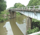
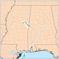
Noxubee River
Encyclopedia
Tributary
A tributary or affluent is a stream or river that flows into a main stem river or a lake. A tributary does not flow directly into a sea or ocean...
of the Tombigbee River
Tombigbee River
The Tombigbee River is a tributary of the Mobile River, approximately 200 mi long, in the U.S. states of Mississippi and Alabama. It is one of two major rivers, along with the Alabama River, that unite to form the short Mobile River before it empties into Mobile Bay on the Gulf of Mexico...
, about 140 mi (225 km) long, in east-central Mississippi
Mississippi
Mississippi is a U.S. state located in the Southern United States. Jackson is the state capital and largest city. The name of the state derives from the Mississippi River, which flows along its western boundary, whose name comes from the Ojibwe word misi-ziibi...
and west-central Alabama
Alabama
Alabama is a state located in the southeastern region of the United States. It is bordered by Tennessee to the north, Georgia to the east, Florida and the Gulf of Mexico to the south, and Mississippi to the west. Alabama ranks 30th in total land area and ranks second in the size of its inland...
in the United States
United States
The United States of America is a federal constitutional republic comprising fifty states and a federal district...
. Via the Tombigbee, it is part of the watershed
Drainage basin
A drainage basin is an extent or an area of land where surface water from rain and melting snow or ice converges to a single point, usually the exit of the basin, where the waters join another waterbody, such as a river, lake, reservoir, estuary, wetland, sea, or ocean...
of the Mobile River
Mobile River
The Mobile River is located in southern Alabama in the United States. Formed out of the confluence of the Tombigbee and Alabama rivers, the approximately river drains an area of of Alabama, with a watershed extending into Mississippi, Georgia, and Tennessee. Its drainage basin is the...
, which flows to the Gulf of Mexico
Gulf of Mexico
The Gulf of Mexico is a partially landlocked ocean basin largely surrounded by the North American continent and the island of Cuba. It is bounded on the northeast, north and northwest by the Gulf Coast of the United States, on the southwest and south by Mexico, and on the southeast by Cuba. In...
.
Course
The Noxubee rises in Choctaw Lake in the Tombigbee National ForestTombigbee National Forest
Tombigbee National Forest is a U.S. National Forest in eastern and northeastern Mississippi. It is named for the nearby Tombigbee River. It is divided geographically into two non-contiguous sections. The larger southern section, about 60% of the total acreage, is located north of Louisville, in...
in Choctaw County, Mississippi
Choctaw County, Mississippi
-National protected areas:* Natchez Trace Parkway * Tombigbee National Forest -Demographics:As of the census of 2000, there were 9,758 people, 3,686 households, and 2,668 families residing in the county. The population density was 23 people per square mile . There were 4,249 housing units at an...
, and flows generally southeastwardly through Winston
Winston County, Mississippi
-Demographics:At the 2000 census, there were 20,160 people, 7,578 households and 5,471 families residing in the county. The population density was 33 per square mile . There were 8,472 housing units at an average density of 14 per square mile...
, Oktibbeha
Oktibbeha County, Mississippi
-National protected areas:*Noxubee National Wildlife Refuge *Tombigbee National Forest -Demographics:As of the census of 2000, there were 42,902 people, 15,945 households, and 9,264 families residing in the county. The population density was 94 people per square mile . There were 17,344 housing...
and Noxubee
Noxubee County, Mississippi
-Demographics:As of the census of 2000, there were 12,548 people, 4,470 households, and 3,222 families residing in the county. The population density was 18 people per square mile . There were 5,228 housing units at an average density of 8 per square mile...
Counties in Mississippi, and Sumter County
Sumter County, Alabama
Sumter County is a county of the U.S. state of Alabama.Its name is in honor of General Thomas Sumter of South Carolina. As of 2010, the population was 13,763. Its county seat is Livingston.-History:...
in Alabama, through the Noxubee National Wildlife Refuge
Noxubee National Wildlife Refuge
Noxubee National Wildlife Refuge is a National Wildlife Refuge located in the U.S. state of Mississippi, in Noxubee, Oktibbeha, and Winston Counties . The refuge serves as a resting and feeding area for migratory birds and as example of proper land stewardship...
and past the town of Macon, Mississippi
Macon, Mississippi
Macon is a city in Noxubee County, Mississippi, United States, along the Noxubee River. The population was 2,461 at the 2000 census. It is the county seat of Noxubee County.-History:...
. It joins the Tombigbee River from the west, about 2 mi (3 km) west of Gainesville, Alabama
Gainesville, Alabama
Gainesville is a town in Sumter County, Alabama, United States. At the 2000 census the population was 220.-Geography:Gainesville is located at .According to the U.S. Census Bureau, the town has a total area of , all of it land....
.
Variant names
According to the Geographic Names Information SystemGeographic Names Information System
The Geographic Names Information System is a database that contains name and locative information about more than two million physical and cultural features located throughout the United States of America and its territories. It is a type of gazetteer...
, the Noxubee River has also been known as:
|
|