

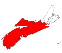
Nova Scotia peninsula
Encyclopedia
Peninsula
A peninsula is a piece of land that is bordered by water on three sides but connected to mainland. In many Germanic and Celtic languages and also in Baltic, Slavic and Hungarian, peninsulas are called "half-islands"....
on the Atlantic
Atlantic Ocean
The Atlantic Ocean is the second-largest of the world's oceanic divisions. With a total area of about , it covers approximately 20% of the Earth's surface and about 26% of its water surface area...
coast of North America
North America
North America is a continent wholly within the Northern Hemisphere and almost wholly within the Western Hemisphere. It is also considered a northern subcontinent of the Americas...
.
Location
The Nova Scotia peninsula is part of the province of Nova ScotiaNova Scotia
Nova Scotia is one of Canada's three Maritime provinces and is the most populous province in Atlantic Canada. The name of the province is Latin for "New Scotland," but "Nova Scotia" is the recognized, English-language name of the province. The provincial capital is Halifax. Nova Scotia is the...
, Canada
Canada
Canada is a North American country consisting of ten provinces and three territories. Located in the northern part of the continent, it extends from the Atlantic Ocean in the east to the Pacific Ocean in the west, and northward into the Arctic Ocean...
and is connected to the neighbouring province of New Brunswick
New Brunswick
New Brunswick is one of Canada's three Maritime provinces and is the only province in the federation that is constitutionally bilingual . The provincial capital is Fredericton and Saint John is the most populous city. Greater Moncton is the largest Census Metropolitan Area...
through the Isthmus of Chignecto
Isthmus of Chignecto
The Isthmus of Chignecto is an isthmus bordering the Maritime provinces of New Brunswick and Nova Scotia which connects the Nova Scotia peninsula with North America....
. It fronts the open Atlantic Ocean on the south and southeast, the Gulf of Maine
Gulf of Maine
The Gulf of Maine is a large gulf of the Atlantic Ocean on the east coast of North America.It is delineated by Cape Cod at the eastern tip of Massachusetts in the southwest and Cape Sable at the southern tip of Nova Scotia in the northeast. It includes the entire coastlines of the U.S...
to the west, the Bay of Fundy
Bay of Fundy
The Bay of Fundy is a bay on the Atlantic coast of North America, on the northeast end of the Gulf of Maine between the Canadian provinces of New Brunswick and Nova Scotia, with a small portion touching the U.S. state of Maine...
and its sub-basins to the northwest, the Northumberland Strait
Northumberland Strait
The Northumberland Strait is a strait in the southern part of the Gulf of Saint Lawrence in eastern Canada...
to the north, and the Strait of Canso
Strait of Canso
The Strait of Canso , is a strait located in the province of Nova Scotia, Canada. It divides the Nova Scotia peninsula from Cape Breton Island....
to the east.
The narrow and deep waters of the Strait of Canso separate the peninsula from Cape Breton Island
Cape Breton Island
Cape Breton Island is an island on the Atlantic coast of North America. It likely corresponds to the word Breton, the French demonym for Brittany....
, the second largest land mass constituting the province of Nova Scotia.
In addition to Cape Breton Island, other much smaller islands are geologically associated with the Nova Scotia peninsula, including Boularderie Island
Boularderie Island
Boularderie Island is an island separating the Cabot Strait from Bras d'Or Lake on the eastern coast of Cape Breton Island, Nova Scotia, Canada. It takes its name from Louis-Simon le Poupet de la Boularderie, who was granted the area as a concession from the King of France.At 40 km long and...
, Brier Island
Brier Island
Brier Island is an island in the Bay of Fundy in Digby County, Nova Scotia.-Geography:The island is the western-most part of Nova Scotia and the southern end of the North Mountain ridge with Long Island lying immediately northeast; both islands constitute part of the Digby Neck...
, Long Island
Long Island (Nova Scotia)
Long Island is a Canadian island in Digby County, Nova Scotia.Situated in the Bay of Fundy immediately southwest of the Digby Neck, Brier Island is located immediately west...
, Pictou Island, Tancook Island
Tancook Island
Tancook Island can refer to two different Canadian islands located in Mahone Bay in Lunenburg County, Nova Scotia:* Big Tancook Island* Little Tancook Island...
and various smaller islands along the Atlantic coast.
Geology
The peninsula can be divided into two distinct geological regions north and south of a fault line (the Cobequid and Chedabucto faults) extending between the Bay of FundyBay of Fundy
The Bay of Fundy is a bay on the Atlantic coast of North America, on the northeast end of the Gulf of Maine between the Canadian provinces of New Brunswick and Nova Scotia, with a small portion touching the U.S. state of Maine...
sub-basins of the Minas Basin
Minas Basin
The Minas Basin is an inlet of the Bay of Fundy and a sub-basin of the Fundy Basin located in Nova Scotia, Canada. It is known for its extremely high tides.- Geography :- Boundary :...
and Cobequid Bay
Cobequid Bay
Cobequid Bay is an inlet of the Bay of Fundy and the easternmost part of the Minas Basin, located in the Canadian province of Nova Scotia. The bay was carved by rivers flowing into the eastern end of the Bay of Fundy....
in the west, through to Chedabucto Bay
Chedabucto Bay
Chedabucto Bay is a large bay on the eastern coast of mainland Nova Scotia between the Atlantic Ocean and the Strait of Canso next to Guysborough County...
in the east.
North
The northern portion of the peninsula is dominated by the Avalon Uplands (the Cobequid Hills and Pictou-Antigonish Highlands) and the Carboniferous Lowlands, the latter of which straddles the fault zone.The Cobequid Hills contains the highest elevation point on the peninsula at Nuttby Mountain
Nuttby Mountain
Nuttby Mountain is a Canadian peak in the Cobequid Hills and the highest elevation point on the mainland portion of Nova Scotia.Located west of Route 311 north of Truro, the peak is accessible by vehicle using a gated road and is topped by telecommunication towers and a forest fire surveillance tower...
. This low, heavily eroded part of the Appalachian Mountains
Appalachian Mountains
The Appalachian Mountains #Whether the stressed vowel is or ,#Whether the "ch" is pronounced as a fricative or an affricate , and#Whether the final vowel is the monophthong or the diphthong .), often called the Appalachians, are a system of mountains in eastern North America. The Appalachians...
, along with the Pictou-Antigonish Highlands, comprises a highland across the northern portion of the peninsula with average elevations between 250-300 meters. It was heavily covered in sediment during glaciation; consequently it hosts an abundant forest as well as agricultural activities.
The Carboniferous Lowlands includes carboniferous sedimentary rocks south of the Minas Basin and along the north shore of the peninsula immediately south of the Northumberland Strait. The area south and east of the Minas Basin is dominated by karst topography lending to numerous gypsum deposits. Coal seams are found in the western and central areas of Cumberland County
Cumberland County, Nova Scotia
Cumberland County is a county in the Canadian province of Nova Scotia.-History:The name Cumberland was applied by Lieutenant-Colonel Robert Monckton to the captured Fort Beauséjour on June 18, 1755 in honour of the third son of King George II, William Augustus, Duke of Cumberland, victor at...
in the Joggins
Joggins, Nova Scotia
Joggins is a Canadian rural community located in western Cumberland County, Nova Scotia. On July 7, 2008 a 15 km length of the coast constituting the Joggins Fossil Cliffs was officially inscribed on the World Heritage List.- History :...
-River Hebert
River Hebert, Nova Scotia
River Hebert is a village on the River Hebert in Cumberland County, Nova Scotia, Canada.It is approximately 25 kilometres southwest of Amherst...
basin and the Springhill
Springhill, Nova Scotia
-Coal mining:The first industrial coal mining in the area took place in the 1870s after a rail connection was built by the Springhill and Parrsboro Coal and Railway Company to the newly completed Intercolonial Railway at neighbouring Springhill Junction....
basin, along with the Debert
Debert, Nova Scotia
Debert is an unincorporated farming community in the Canadian province of Nova Scotia. It is located approximately 20 km west of the town of Truro. The Village of Debert is home to two churches, Baptist and United, plus a Fellowship Center, as well as a gas station and two garages. There are...
basin and the Pictou
Pictou County, Nova Scotia
Pictou County is a county in the Canadian province of Nova Scotia. It was established in 1835, and was formerly a part of Halifax County from 1759 to 1835. It had a population of 46,513 people in 2006, which represents a decline of 6.3 percent from 1991. It is the sixth most populous county in Nova...
basin.
Throughout the northern portion of the peninsula, the lowland plains, rolling uplands, and coastal fringe areas support numerous settlements, many of which developed around mineral extraction, particularly coal. When included with the Sydney
Sydney, Nova Scotia
Sydney is a Canadian urban community in the province of Nova Scotia. It is situated on the east coast of Cape Breton Island and is administratively part of the Cape Breton Regional Municipality....
and Inverness
Inverness, Nova Scotia
Inverness is a Canadian rural community in Inverness County, Nova Scotia. In 2001 its population was 2,496.Located on the west coast of Cape Breton Island fronting the Gulf of St...
coal fields on Cape Breton Island, these regions were extremely prominent in the industrial and social development of Nova Scotia.
South
In addition to sharing the Carboniferous Lowlands, the southern portion of the peninsula is dominated by the Atlantic Interior (Sissiboo Lowlands, South MountainSouth Mountain (Nova Scotia)
South Mountain is a Canadian range on the mainland portion of Nova Scotia. A granitic ridge stretching from the Annapolis Basin to Mount Uniacke, it forms the southern edge of the Annapolis Valley and shelters the valley from the climate effects of the pelagic coast along the Atlantic Ocean.In...
, various slate ridges), followed by the comparatively small Triassic Lowlands (the Annapolis Valley
Annapolis Valley
The Annapolis Valley is a valley and region in the Canadian province of Nova Scotia. It is located in the western part of the Nova Scotia peninsula, formed by a trough between two parallel mountain ranges along the shore of the Bay of Fundy.-Geography:...
), and the Fundy Coast (including Economy Mountain and North Mountain) and Atlantic Coast regions.
The Atlantic Interior is dominated by a glacial landscape of exposed granitic rock, thick forest, drumlins and numerous lakes. The Sissiboo Lowlands comprise many river valleys and lowland inland areas in the southwest and central portion of the peninsula. The South Mountain is a steadily rising slope that descends sharply at the Annapolis Valley but more gradually toward the Atlantic, resulting in a plateau across much of the southwest interior of the peninsula with average elevations of 150 m and maximum elevations of 275 m. Slate ridges are prominent in the Rawdon Hills and Wittenburg Ridge areas along the boundary with the Carboniferous Lowlands.
The Fundy Coast region includes the North Mountain ridge as well as the Digby Neck
Digby Neck
Digby Neck is a Canadian peninsula extending into the Bay of Fundy in Digby County, Nova Scotia.Digby Neck is the western extension of the North Mountain range from the Annapolis Valley and is made of two thick lava flows. It is separated from the eastern portion of the North Mountain by a deep,...
and the Economy Mountain areas along the north side of the Minas Basin. The Atlantic Coast region includes the barren and wind-swept regions from Yarmouth
Yarmouth, Nova Scotia
Yarmouth is a town and fishing port located on the Gulf of Maine in rural southwestern Nova Scotia, Canada. It is the shire town of Yarmouth County. The town is located in the heart of the world's largest lobster fishing grounds and has Canada's highest lobster catch.- History :The townsite may...
to Canso
Canso, Nova Scotia
For the headland, see Cape Canso.Canso is a small Canadian town in Guysborough County, on the north-eastern tip of mainland Nova Scotia, next to Chedabucto Bay. The area was established in 1604, along with Port Royal, Nova Scotia. The British construction of a fort in the village , was instrumental...
, extending several kilometres inland.
The Triassic Lowlands is an area of soft sandstone, much of which is covered by water resulting from sea level rise. The remnant is the open ended Annapolis Valley which is sheltered by the Fundy Coast and the Atlantic Interior, providing a micro-climate unique to the Atlantic provinces and conducive to fruit and vegetable farming.
Historic name
- The present-day use of the term Acadian PeninsulaAcadian PeninsulaThe Acadian Peninsula is situated in the northeastern corner of New Brunswick, Canada, encompassing portions of Gloucester and Northumberland Counties. It derives its name from the large Acadian population located there...
refers to a peninsula in northeastern New BrunswickNew BrunswickNew Brunswick is one of Canada's three Maritime provinces and is the only province in the federation that is constitutionally bilingual . The provincial capital is Fredericton and Saint John is the most populous city. Greater Moncton is the largest Census Metropolitan Area...
.
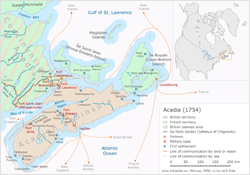
Acadia
Acadia was the name given to lands in a portion of the French colonial empire of New France, in northeastern North America that included parts of eastern Quebec, the Maritime provinces, and modern-day Maine. At the end of the 16th century, France claimed territory stretching as far south as...
, which focused its settlement efforts along the southern and northeastern shores of Baie Francois (now the Bay of Fundy
Bay of Fundy
The Bay of Fundy is a bay on the Atlantic coast of North America, on the northeast end of the Gulf of Maine between the Canadian provinces of New Brunswick and Nova Scotia, with a small portion touching the U.S. state of Maine...
).
The Treaty of Utrecht
Treaty of Utrecht
The Treaty of Utrecht, which established the Peace of Utrecht, comprises a series of individual peace treaties, rather than a single document, signed by the belligerents in the War of Spanish Succession, in the Dutch city of Utrecht in March and April 1713...
in 1713 gave Great Britain
Great Britain
Great Britain or Britain is an island situated to the northwest of Continental Europe. It is the ninth largest island in the world, and the largest European island, as well as the largest of the British Isles...
control of "Acadia
Acadia
Acadia was the name given to lands in a portion of the French colonial empire of New France, in northeastern North America that included parts of eastern Quebec, the Maritime provinces, and modern-day Maine. At the end of the 16th century, France claimed territory stretching as far south as...
", however the boundaries were never properly defined. Acadia is considered by many historians to have encompassed present-day New Brunswick
New Brunswick
New Brunswick is one of Canada's three Maritime provinces and is the only province in the federation that is constitutionally bilingual . The provincial capital is Fredericton and Saint John is the most populous city. Greater Moncton is the largest Census Metropolitan Area...
, eastern Maine
Maine
Maine is a state in the New England region of the northeastern United States, bordered by the Atlantic Ocean to the east and south, New Hampshire to the west, and the Canadian provinces of Quebec to the northwest and New Brunswick to the northeast. Maine is both the northernmost and easternmost...
, Anticosti Island
Anticosti Island
Anticosti Island is an island at the outlet of the Saint Lawrence River into the Gulf of Saint Lawrence, in Quebec, Canada, between 49° and 50° N., and between 61° 40' and 64° 30' W. At in size, it is the 90th largest island in the world and 20th largest island in Canada...
, the Gaspé Peninsula
Gaspé Peninsula
The Gaspésie , or Gaspé Peninsula or the Gaspé, is a peninsula along the south shore of the Saint Lawrence River in Quebec, Canada, extending into the Gulf of Saint Lawrence...
, Prince Edward Island
Prince Edward Island
Prince Edward Island is a Canadian province consisting of an island of the same name, as well as other islands. The maritime province is the smallest in the nation in both land area and population...
and Cape Breton Island
Cape Breton Island
Cape Breton Island is an island on the Atlantic coast of North America. It likely corresponds to the word Breton, the French demonym for Brittany....
- in other lands along the southern and western shores of the Gulf of St. Lawrence (some treaties have placed the boundary of Acadia as far south as Massachusetts
Massachusetts
The Commonwealth of Massachusetts is a state in the New England region of the northeastern United States of America. It is bordered by Rhode Island and Connecticut to the south, New York to the west, and Vermont and New Hampshire to the north; at its east lies the Atlantic Ocean. As of the 2010...
).
The large peninsula that is today the mainland portion of the province of Nova Scotia was referred to as the Acadian Peninsula at the time that Britain took control, with this territory falling under the Colony of Nova Scotia.
Note
See also
- Isthmus of ChignectoIsthmus of ChignectoThe Isthmus of Chignecto is an isthmus bordering the Maritime provinces of New Brunswick and Nova Scotia which connects the Nova Scotia peninsula with North America....
- Geography of Nova ScotiaGeography of Nova ScotiaNova Scotia is a province located in eastern Canada fronting the Atlantic Ocean. One of the Maritime Provinces, Nova Scotia's geography is complex, despite its relatively small size in comparison to other Canadian provinces.-Physical geography:...