

Northwest Parkway
Encyclopedia
E-470
E-470 is a 46-mile limited-access tollway traversing the eastern portion of the Denver-Aurora Metropolitan Area in Colorado. The toll road is not a state highway, but is instead maintained by the E-470 Public Highway Authority.-Route description:...
to US 36 at 96th Street. Both termini are in Broomfield, Colorado
Broomfield, Colorado
The City and County of Broomfield is a prominent suburb and tier of the Denver metropolitan area in the State of Colorado of the United States. Broomfield has a consolidated city and county government which operates under Article XX, Sections 10-13 of the Constitution of the State of Colorado. The...
, northwest of Denver
Denver, Colorado
The City and County of Denver is the capital and the most populous city of the U.S. state of Colorado. Denver is a consolidated city-county, located in the South Platte River Valley on the western edge of the High Plains just east of the Front Range of the Rocky Mountains...
. In combination with E-470
E-470
E-470 is a 46-mile limited-access tollway traversing the eastern portion of the Denver-Aurora Metropolitan Area in Colorado. The toll road is not a state highway, but is instead maintained by the E-470 Public Highway Authority.-Route description:...
(47 miles) and SH 470
Colorado State Highway 470
State Highway 470 is the southwestern portion of the Denver Metro area's beltway. Originally planned as Interstate 470 in the 1960s, the beltway project was attacked on environmental impact grounds and the interstate beltway was never built...
(27 miles), the Northwest Parkway forms a partial beltway of approximately 85 miles (136.8 km) around the Denver-Aurora Metropolitan Area
Denver-Aurora Metropolitan Area
The Denver-Aurora-Broomfield, CO Metropolitan Statistical Area is a United States Census Bureau defined Metropolitan Statistical Area in the State of Colorado that includes the City and County of Denver and nine suburban counties. The Census Bureau estimates that the population was 2,357,404 on...
. Some 19 miles (30.6 km) lie between the west end of the Northwest Parkway and the northwest end of SH 470, the opposite end of the beltway.
The Northwest Parkway was funded entirely with private money and charges a $3 toll. The toll rate of approximately 27 cents per mile is one of the highest rates of any toll road in the United States.
Tolls may be paid using highway-speed electronic tolling
Electronic toll collection
Electronic toll collection , an adaptation of military "identification friend or foe" technology, aims to eliminate the delay on toll roads by collecting tolls electronically. It is thus a technological implementation of a road pricing concept...
.
Route description
Northwest Parkway begins as a continuation of E-470E-470
E-470 is a 46-mile limited-access tollway traversing the eastern portion of the Denver-Aurora Metropolitan Area in Colorado. The toll road is not a state highway, but is instead maintained by the E-470 Public Highway Authority.-Route description:...
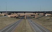
westward. Following a stack interchange
Stack interchange
A stack interchange is a free-flowing grade separated junction between two roads.In countries where one drives on the right, left turns are handled by semi-directional flyover/under ramps...
with Interstate 25
Interstate 25
Interstate 25 is an Interstate Highway in the western United States. It is primarily a north–south highway. I-25 stretches from Interstate 10 at Las Cruces, New Mexico, , to Interstate 90 in Buffalo, Wyoming, .Interstate 25 is the main north–south expressway through...
, the parkway crosses Huron Street in suburban Broomfield, surrounded by fields. After intersecting Sheridan Parkway the route passes a small pond, followed by an intersection with Lowell Blvd. Near Dillon Road the parkway interchanges with U.S. Route 287
U.S. Route 287
U.S. Route 287 is a north–south United States highway. It is long. It serves as the major truck route between the Texas cities of Fort Worth and Amarillo...
in Lafayette
Lafayette, Colorado
The City of Lafayette is a Home Rule Municipality located in Boulder County, Colorado, United States. The United States Census Bureau estimates that the city population was 23,884 on 2005-07-01.- Geography :Lafayette is located at ....
before reentering Broomfield at its west end at 96th Street.
History
The Northwest Parkway opened to the public in November 2003. In November 2005, a new intersection opened at Sheridan Boulevard in northern Broomfield. In August 2001, the cities of WestminsterWestminster, Colorado
Westminster is a Home Rule Municipality in Adams and Jefferson counties in the U.S. state of Colorado. Westminster is a northwest suburb of Denver. The Westminster Municipal Center is located north-northwest of the Colorado State Capitol. The United States Census Bureau that the city population...
and Arvada
Arvada, Colorado
The City of Arvada is a Home Rule Municipality located in Jefferson and Adams counties in the Denver metropolitan area of the U.S. State of Colorado. Olde Town Arvada is located northwest of the Colorado State Capitol in Denver...
put into motion the completion of an extension of the Northwest Parkway, sometimes termed W-470, to connect to SH 470, I-70 and US 6 in Golden
Golden, Colorado
The City of Golden is a home rule municipality that is the county seat of Jefferson County, Colorado, United States. Golden lies along Clear Creek at the edge of the foothills of the Front Range of the Rocky Mountains. Founded during the Pike's Peak Gold Rush on 16 June 1859, the mining camp was...
. The city of Golden struck down the proposal, but in a compromise with the Colorado Department of Transportation, an environmental impact study is being done with a goal of CDOT to complete the beltway by 2015. Most likely, Indiana Street and SH 93
Colorado State Highway 93
State Highway 93 is a highway in Colorado that connects Golden and Boulder.-Route description:SH 93 runs , starting at its southern junction with U.S. Highway 6 at the entrance to Clear Creek Canyon in Golden...
would be used to complete the beltway.
Lease to foreign consortium
In 2007, the board of directors of the Northwest Parkway agreed to lease the operations of the highway to a consortium for 99 years. The two companies of the consortium are Brisa - Auto-estradas de PortugalBrisa - Auto-estradas de Portugal
Brisa – Auto-estradas de Portugal, S.A. is Portugal-based international transportation company. The group's largest business area is highway management, in which it is the largest concessionaire in its home country. Founded in 1972, Brisa also has significant operations in countries including the...
and Companhia de Concessões Rodoviárias
Companhia de Concessões Rodoviárias
CCR - Companhia de Concessões Rodoviárias is a holding company with interests in private interstate highway concessions in Brazil...
. According to the Boulder Daily Camera
Daily Camera
The Camera is a daily newspaper in Boulder, Colorado. It is owned by Prairie Mountain Publishing, a division of MediaNews Group.-History:Frederick P. Johnson and Bert Bell founded the weekly Boulder Camera in 1890, and it became a daily in 1891. Ownership has changed several times...
, this was the fourth time in two years that operations of an existing toll road in the USA had been turned over to a private company under a long-term lease.
The Northwest Parkway had been consistently generating less income than envisioned when it was funded by three local governments — Broomfield, Lafayette, and Weld County. The parkway was built with $416.4 million in bonds, to be paid back with toll revenue over 35 years. Due to the road's under-utilization, the bond debt was downgraded in 2006. Utilization in 2007 was 12,000 cars per day, well below the 18,500 expected by 2004, one year after opening.
Exit list
{|class=wikitable!County
!Location
!Mile
!#
Exit number
An exit number is a number assigned to a road junction, usually an exit from a freeway. It is usually marked on the same sign as the destinations of the exit, as well as a sign in the gore....
!Destinations
!Notes
|-
|colspan=2 rowspan=3|Broomfield
Broomfield, Colorado
The City and County of Broomfield is a prominent suburb and tier of the Denver metropolitan area in the State of Colorado of the United States. Broomfield has a consolidated city and county government which operates under Article XX, Sections 10-13 of the Constitution of the State of Colorado. The...
|46.398
46.950
|47
|
|East end of Northwest Parkway; continues east as E-470
E-470
E-470 is a 46-mile limited-access tollway traversing the eastern portion of the Denver-Aurora Metropolitan Area in Colorado. The toll road is not a state highway, but is instead maintained by the E-470 Public Highway Authority.-Route description:...
|-
|48.070
|48
|Sheridan Parkway
|
|-
|49.280
|colspan=3 align=center|Toll plaza
|-
|Boulder
Boulder County, Colorado
Boulder County is the sixth most populous of the 64 counties of the state of Colorado of the United States. The county seat is Boulder. The most populous municipality in the county and the county seat is the City of Boulder...
|Lafayette
Lafayette, Colorado
The City of Lafayette is a Home Rule Municipality located in Boulder County, Colorado, United States. The United States Census Bureau estimates that the city population was 23,884 on 2005-07-01.- Geography :Lafayette is located at ....
|52.360
|52
|
|
|-
|colspan=2|Broomfield
Broomfield, Colorado
The City and County of Broomfield is a prominent suburb and tier of the Denver metropolitan area in the State of Colorado of the United States. Broomfield has a consolidated city and county government which operates under Article XX, Sections 10-13 of the Constitution of the State of Colorado. The...
|54.450
|
|96th Street – Louisville
Louisville, Colorado
Louisville is a Home Rule Municipality in Boulder County, Colorado, United States. The population was 18,937 at the 2000 census. Louisville began as a rough mining community in 1877, suffered through a period of extraordinary labor violence early in the 20th century, and then, when the mines...
|At-grade; west end of Northwest Parkway
|-