

North York Moors
Encyclopedia
The North York Moors is a national park
in North Yorkshire
, England. The moors are one of the largest expanses of heather
moorland
in the United Kingdom
. It covers an area of 1436 km² (554.4 sq mi), and it has a population of about 25,000. The North York Moors became a National Park
in 1952, through the National Parks and Access to the Countryside Act of 1949.
coast. The northern and western boundaries are defined by the steep scarp slopes of the Cleveland Hills
edging the Tees lowlands and the Hambleton Hills
above the Vale of Mowbray
. To the south lies the broken line of the Tabular Hills
and the Vale of Pickering
.
Four roads cross the moors from north to south. In the east the A171
joins Whitby
and Scarborough. Further inland, the A169 runs between Pickering
and Whitby. More centrally, a minor road departs from the A170
at Keldholme and passes through Castleton
before joining the A171 which connects Whitby and Guisborough
. The most westerly route is the B1257 connecting Helmsley
to Stokesley
. The A170 from Thirsk to Scarborough marks the southern boundary of the moors area.
There is an east-west branch line rail link from Whitby to Middlesbrough
in the north and the North Yorkshire Moors steam railway runs from Pickering to Grosmont with a link to Whitby.
The Moorsbus
Network offers an alternative way around the North York Moors, instead of using private cars.
Snowfall is variable from year to year, but the area gets much more snow on average than other parts of the country. Heavy falls are associated with north-easterly winds off the North Sea. Roads over the high moors are notoriously prone to drifting snow due to the exposed nature of the terrain.
Average recordings are:
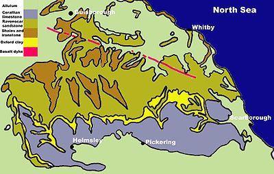 The geology of the North York Moors is dominated by rocks of the Jurassic period. They were mostly laid down in tropical seas 205 to 142 million years ago. Fluctuations in sea level produced different rock types varying from shales to sandstones and limestones derived from coral. These marine and delta deposited rocks are superbly exposed on the Yorkshire coast from Staithes to Filey.
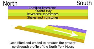 Subsequently, about 30 million years ago, the land was uplifted and tilted towards the south by earth movements. The upper layers of rock were eroded away and the older rocks were exposed in places. Because of the tilt the oldest rocks became exposed in the north. These are the bands of shales and ironstones on the northern scarp of the moors and Cleveland Hills. The middle layers form the sandstones of the high moors and the youngest layers of limestone form the tabular hills. In the dales where the rivers have cut through the younger rocks there are also exposures of older shales, ironstone and sandstone. Rosedale is an example of this.
During the Quaternary period, the last 2 million years, the area has experienced a sequence of glaciations. The most recent glaciation, the Devensian, ended about 20,000 years ago. The higher parts of the North York Moors were not covered by the ice sheets but glaciers flowed southwards on either side of the higher land mass.
As the climate became warmer at the end of the ice age the snowfields on the moors began to melt. The meltwater was unable to escape northwards, westwards or eastwards because it was blocked by ice. Huge torrents of water were forced southwards. Water from the Esk valley area flowed southwards gouging out the deep Newtondale valley as it went. Water from the moors formed a vast lake in the area of the Vale of Pickering. Eventually this lake filled its basin and then overflowed at the lowest point which was at Kirkham. Here it cut the steep sided Kirkham gorge. When the ice finally retreated it left deep deposits of boulder clay (or till
) behind. The boulder clay blocked the eastern end of the Vale of Pickering causing a permanent deviation in the course of the River Derwent. Alluvium
from the glacial meltwater covers many areas to the north of the moors and in the Esk valley.
.
To the south the moors are drained by the River Derwent, Yorkshire
and its tributary the River Rye. The Derwent crosses the Vale of Pickering flowing westwards, turns southwards at Malton and flows through the eastern part of the Vale of York
before emptying into the River Ouse
at Barmby on the Marsh
.
 The North York Moors National Park encompasses two main types of landscape, whose differences are clearly visible, and the coastal belt. There are predominantly green areas of pasture land and the purple and brown heather moorland. The two kinds of scenery are the result of differences in the underlying geology and each supports different wildlife communities.
The acid soils and peat bogs are unsuitable for earthworms so species which usually feed on earthworms such as moles
and the common shrew
are absent on the moors. The pygmy shrew
survives by eating the insects and spiders that live in the heather. Lapwing
, curlew
and redshank
breed on the moors and there are sandpipers along the streams. Wheatear
and golden plover
s inhabit grassier patches on the moors and ring ouzel
s live in stony areas. Red grouse
, which feed on young heather shoots, are abundant. The heather is burned in strips by gamekeepers and farmers to encourage new heather growth to feed the grouse. Grouse shooting is part of the moorland economy.
About 20 per cent of the national park is covered in bracken
. Few things can grow under its dense cover and it does not support many insects and is unpalatable to most animals. The bracken is extremely invasive.
Sheep are a ubiquitous part of the moorland landscape. Their grazing helps to maintain the open wild landscape that is needed for many other plants and animals to thrive.
and grayling
. Insects which emerge from the water in summer are also a rich source of food for birds. Grey wagtail
s, swallows
and spotted flycatcher
s are commonly seen. Dipper
s and kingfishers are also typical. The otter
, after a period of decline, is starting to recolonise the rivers and streams.
Farndale is famous for its wild daffodils in spring. Sheltered woodlands dominated by sessile oak
s can be found to the south of the high ground. These woodland areas are the home of pied flycatchers, sparrow hawks and wood warbler
s. Roe and fallow deer
can also be found here. The woodlands and south facing grasslands on the limestone belt provide a good habitat for many butterflies.
The fertile alkaline soils support an abundance of wild flowers. Bluebell
s and primrose
s grow in the hedgerows in spring and rarer plants such as the wood vetch and orchids are also to be found.
Adder
s are widespread throughout the national park. On the moors they eat common lizards and around the hedgerows and woodland edges they feed on mice and voles.
The Limestone grasslands support a wide variety of wild flowers, and many rarer butterflies can be seen. Pearl-bordered Fritillary
, Duke of Burgundy Fritillary, Marbled White, Dingy Skipper
and Grayling
are just some of species that inhabit the national park.
. The cliff at Boulby, at 690 feet (210.3 m), is the highest point on the east coast of England. Here the Jurassic strata of shales, clays and ironstones are displayed with superb clarity. There are also fine exposures of Jurassic rocks with their characteristic fossils around Robin Hoods Bay and Ravenscar.
Rocky shores offer an abundance of seaweeds in zones of different types which are more and less tolerant of exposure to the air and salt or clear water. Rock pools contain sea anemone
s, blennies, crab
s and molluscs.
Sandy shores harbour a variety of plants and animals which are buried in the sand. Birds such as curlews
and oyster catcher
s are to be seen prodding the sand to find these creatures for food. A few cormorant
s and fulmar
s breed along the coast where stonechat
s and rock pipit
s can also be spotted. Herring gulls are the commonest breeding birds and are an interesting sight nesting in the chimneys of coastal towns.
s. Radio carbon dating of pollen grains preserved in the moorland peat provides a record of the actual species of plants that existed at various periods in the past.
About 10,000 years ago the cold climate of the ice age ameliorated and temperatures rose above growing point of 5.5 °C.Plant life was gradually re-established and animals and humans also returned.
. However, Christianity came to Yorkshire when King Edwin of Northumbria was baptised in AD 627 at York. Christian monasteries were established at Lastingham in 654 and Whitby in 657. A nunnery was built at Hackness in 680.
In the ninth century Viking
raiders began to attack the Yorkshire coast and in 867 these Danes destroyed the religious houses at Whitby, Lastingham and Hackness and after battle set up a new Danish kingdom based at York. The Danes settled in the area and later themselves became Christian. They introduced their language, elements of which still remain in the local dialect, and renamed a number of settlements.
, Rievaulx Abbey
, Byland Abbey
and Mount Grace Priory
. Gifts of land and money were bestowed on these establishments and the monastic orders became notable landowners, eventually owning about a third of the land in the area. The abbeys managed their land as sheep farms and became very rich on the profits. They continued to take in land from the waste and what remained of the forest and in the process gave the moors the distinctive landscape that still remains. Being envious of the wealth of the monasteries, Henry VIII of England closed them down, and confiscated and sold off their property. This was bought by individual people, some rich but some who had been tenants of the monasteries, and became privately owned land.
Locally sourced iron ore has been processed on the North York Moors from medieval times. In the 19th century it became a boom industry. Dozens of ironstone mines and several short-lived blast furnaces were constructed. Between 1856 and 1926 high-grade magnetic ironstone was mined in Rosedale. A railway was built around the top of the dale to serve the mines, and kilns were built to process the ore. In two decades the population of the valley rose from 558 to nearly 3000.Poor-quality coal
was mined in many places on the moors from the 18th century to the early 20th century.
The North York Moors is the only source for British jet
. It has been mined in the area from prehistoric times but the industry grew in the middle of the 19th century in response to a fashion for the jewellery produced from it. In the 1880s cheap imports produced a decline in the industry which was focused on Whitby. The remains of alum quarries are to be found to the north of the area and along the coast. Alum
was important to the textile industry because it was used as a mordant or fixative for dyes that were used to colour cloth. The industry thrived in the region from the early 17th century until 1871. Its decline came when chemical dyes were discovered. The scars of industrial activity on the moors make it an interesting area in which to pursue industrial archaeology.
 The area's economy is mainly founded on tourism
and agriculture
.
has become questionable. A number of environmental schemes to improve farm incomes have been devised but the industry continues to decline.
Agricultural use of the moors is shared with grouse shooting as a means of gaining financial return from the vast expanse of heather. There is richer farmland across the southern limestone belt, where there are arable and mixed farms as well as the livestock farms. The main arable crops are barley, wheat, oilseed rape, potatoes, and sugar beets. There is also some intensive production of pigs and poultry.
; the parks have a network of rights-of-way almost 2300 km (1400 miles) in length, and most of the areas of open moorland will be open access under the Countryside and Rights of Way Act 2000
. Popular named walks include the Cleveland Way
, which circles the moors, and has a section along the coast; and the Lyke Wake Walk
, which leads directly across the heart of the moors. The area also offers opportunities for cycling
, mountain biking
, and horse-riding, including a circular long distance bridleroute created around the North York Moors which can be accessed at a number of locations. The steep escarpments that define the edges of the park on three sides are used by several gliding
clubs.
programmes and films.The series Heartbeat and the scenes of The Hogsmeade Station in the Harry Potter movies were filmed in Goathland
. Dalby Forest
is also host to many forms of entertainment throughout the year including outdoor concerts.
, Pickering
, Kirkbymoorside
, Guisborough
, Stokesley
, Northallerton
and Whitby
. The moors are within a reasonable distance of Redcar
and form part of East Cleveland. The moors are also within 20 minutes driving time from central Middlesbrough
and Scarborough.
National parks of England and Wales
The national parks of England and Wales are areas of relatively undeveloped and scenic landscape that are designated under the National Parks and Access to the Countryside Act 1949...
in North Yorkshire
North Yorkshire
North Yorkshire is a non-metropolitan or shire county located in the Yorkshire and the Humber region of England, and a ceremonial county primarily in that region but partly in North East England. Created in 1974 by the Local Government Act 1972 it covers an area of , making it the largest...
, England. The moors are one of the largest expanses of heather
Calluna
Calluna vulgaris is the sole species in the genus Calluna in the family Ericaceae. It is a low-growing perennial shrub growing to tall, or rarely to and taller, and is found widely in Europe and Asia Minor on acidic soils in open sunny situations and in moderate shade...
moorland
Moorland
Moorland or moor is a type of habitat, in the temperate grasslands, savannas, and shrublands biome, found in upland areas, characterised by low-growing vegetation on acidic soils and heavy fog...
in the United Kingdom
United Kingdom
The United Kingdom of Great Britain and Northern IrelandIn the United Kingdom and Dependencies, other languages have been officially recognised as legitimate autochthonous languages under the European Charter for Regional or Minority Languages...
. It covers an area of 1436 km² (554.4 sq mi), and it has a population of about 25,000. The North York Moors became a National Park
National park
A national park is a reserve of natural, semi-natural, or developed land that a sovereign state declares or owns. Although individual nations designate their own national parks differently A national park is a reserve of natural, semi-natural, or developed land that a sovereign state declares or...
in 1952, through the National Parks and Access to the Countryside Act of 1949.
Location and transport
To the east the area is clearly defined by the impressive cliffs of the North SeaNorth Sea
In the southwest, beyond the Straits of Dover, the North Sea becomes the English Channel connecting to the Atlantic Ocean. In the east, it connects to the Baltic Sea via the Skagerrak and Kattegat, narrow straits that separate Denmark from Norway and Sweden respectively...
coast. The northern and western boundaries are defined by the steep scarp slopes of the Cleveland Hills
Cleveland Hills
The Cleveland Hills are a range of hills on the north-west edge of the North York Moors in North Yorkshire, England, overlooking Cleveland and Teesside. They lie entirely within the boundaries of the North York Moors National Park. Part of the long Cleveland Way National Trail runs along the...
edging the Tees lowlands and the Hambleton Hills
Hambleton Hills
The Hambleton Hills are a range of hills in North Yorkshire in the United Kingdom. They form the western edge of the North Yorkshire Moors but are separated from the moors by the valley of the River Rye...
above the Vale of Mowbray
Vale of Mowbray
The Vale of Mowbray is a stretch of low lying land between the North Yorkshire Moors and the Hambleton Hills to the east and the Yorkshire Dales to the west...
. To the south lies the broken line of the Tabular Hills
Tabular Hills
The Tabular Hills are an east west line of distinct hills on the southern boundary of the North Yorkshire Moors, running from Scarborough in the east all the way to Black Hambleton in the west. The name refers to their flat tabular shaped summits composed of hard Corallian limestone known...
and the Vale of Pickering
Vale of Pickering
The Vale of Pickering is a low-lying flat area of land in North Yorkshire, England. It is drained by the River Derwent. The landscape is rural with scattered villages and small market towns. It has been inhabited continuously from the Mesolithic period...
.
Four roads cross the moors from north to south. In the east the A171
A171 road
The A171 is a road in England that links the North Yorkshire towns of Middlesbrough and Scarborough. Locally it is known as The Moors Road.It takes the following route*starts at Middlesbrough, heads south*turns east at Nunthorpe*past Guisborough...
joins Whitby
Whitby
Whitby is a seaside town, port and civil parish in the Scarborough borough of North Yorkshire, England. Situated on the east coast of Yorkshire at the mouth of the River Esk, Whitby has a combined maritime, mineral and tourist heritage, and is home to the ruins of Whitby Abbey where Caedmon, the...
and Scarborough. Further inland, the A169 runs between Pickering
Pickering, North Yorkshire
Pickering is an ancient market town and civil parish in the Ryedale district of the county of North Yorkshire, England, on the border of the North York Moors National Park. It sits at the foot of the Moors, overlooking the Vale of Pickering to the south...
and Whitby. More centrally, a minor road departs from the A170
A170 road
The A170 is an A road in North Yorkshire, England. It begins at Thirsk, spouting off from the A19 road after about it reaches the very steep viewpoint Sutton Bank, after a steep climb it enters the North Yorkshire Moors and the Hambleton Hills then it reaches the small town of Helmsley and the...
at Keldholme and passes through Castleton
Castleton, North Yorkshire
Castleton is a village on the River Esk, part of the civil parish of Danby in the county of North Yorkshire in England. It can be found about 15 miles south-east of Middlesbrough, in the North York Moors. There was once a medieval castle sited on Castle Hill....
before joining the A171 which connects Whitby and Guisborough
Guisborough
Guisborough is a market town and civil parish within the unitary authority of Redcar and Cleveland and the ceremonial county of North Yorkshire, England....
. The most westerly route is the B1257 connecting Helmsley
Helmsley
Helmsley is a market town and civil parish in the Ryedale district of North Yorkshire, England. The town is located at the point where the valleys of Bilsdale and Ryedale leave the higher moorland and join the flat Vale of Pickering. It is situated on the River Rye and lies on the A170 road, east...
to Stokesley
Stokesley
Stokesley is a small market town and civil parish in the Hambleton district of North Yorkshire, England. It lies on the River Leven. Stokesley is located about two miles south of the boundary of the borough of Middlesbrough and ten miles south of Middlesbrough town centre. Stokesley is located...
. The A170 from Thirsk to Scarborough marks the southern boundary of the moors area.
There is an east-west branch line rail link from Whitby to Middlesbrough
Middlesbrough
Middlesbrough is a large town situated on the south bank of the River Tees in north east England, that sits within the ceremonial county of North Yorkshire...
in the north and the North Yorkshire Moors steam railway runs from Pickering to Grosmont with a link to Whitby.
The Moorsbus
Moorsbus
Moorsbus is a network of bus services operating to and around the North York Moors national park and surrounding areas. It has been operational since the 1980s, and links places such as Darlington, Hartlepool, Middlesbrough, York and Hull to the national park...
Network offers an alternative way around the North York Moors, instead of using private cars.
Climate
As part of the United Kingdom, the North York Moors area generally has warm summers and relatively mild winters. Weather conditions vary from day to day as well as from season to season. The latitude of the area means that it is influenced by predominantly westerly winds with depressions and their associated fronts, bringing with them unsettled and windy weather, particularly in winter. Between depressions there are often small mobile anticyclones that bring periods of fine weather. In winter anticyclones bring cold dry weather. In summer the anticyclones tend to bring dry settled conditions which can lead to drought. For its latitude this area is milder in winter and cooler in summer due to the influence of the Gulf Stream in the northern Atlantic Ocean. Air temperature varies on a daily and seasonal basis. The temperature is usually lower at night and January is the coldest time of the year. The two dominant influences on the climate of the North York Moors are the shelter against the worst of the moist westerly winds provided by the Pennines and the proximity of the North Sea. Late, chilly springs and warm summers are a feature of the area but there are often spells of fine autumn weather. Onshore winds in spring and early summer bring mists or low stratus clouds (known locally as sea frets) to the coasts and moors. Within the area variations in climate are brought about by local differences in altitude, aspect and shelter.Snowfall is variable from year to year, but the area gets much more snow on average than other parts of the country. Heavy falls are associated with north-easterly winds off the North Sea. Roads over the high moors are notoriously prone to drifting snow due to the exposed nature of the terrain.
Average recordings are:
- 100 wet days
- 215 dry days
- 50 snow fall days
- rainfall of 1000 mm to 1520 mm (39 in to 60 in) near the coast
- rainfall of 635 mm to 760 mm (25 in to 30 in) inland
- summer temperatures of 20 °C to 32 °C (68 °F to 90 °F)
- winter temperatures of -1 °C to 10 °C (30 °F to 50 °F)
Geology
- Lower Jurassic At the beginning of the Jurassic period shales, clays and thin limestones and sandstones were deposited in a shallow sea. These deposits are many metres thick and include layers of ironstoneIronstoneIronstone is a sedimentary rock, either deposited directly as a ferruginous sediment or created by chemical repacement, that contains a substantial proportion of an iron compound from which iron either can be or once was smelted commercially. This term is customarily restricted to hard coarsely...
of various thicknesses and the rocks from which alumAlumAlum is both a specific chemical compound and a class of chemical compounds. The specific compound is the hydrated potassium aluminium sulfate with the formula KAl2.12H2O. The wider class of compounds known as alums have the related empirical formula, AB2.12H2O.-Chemical properties:Alums are...
is extracted. - Middle Jurassic A period of gradual uplift happened when mudstone and sandstone were deposited on a low lying coastal plain crossed by large rivers. Occasionally this land area was inundated by the sea and at these times calcarious rocks containing marine fossils were deposited. These are the Ravenscar Group of rocks. The Oxford Clay was deposited at the end of this era.
- Upper Jurassic Towards the end of the Jurassic period the land again sank beneath the sea. At first the sea was shallow and calcareous sandstones and limestones were deposited. These are the Corallian rocks of the Tabular Hills towards the south of the area. Overlying the Corallian rocks is the Kimmeridge Clay which underlies the Vale of Pickering but this is not exposed on the surface.
During the Quaternary period, the last 2 million years, the area has experienced a sequence of glaciations. The most recent glaciation, the Devensian, ended about 20,000 years ago. The higher parts of the North York Moors were not covered by the ice sheets but glaciers flowed southwards on either side of the higher land mass.
As the climate became warmer at the end of the ice age the snowfields on the moors began to melt. The meltwater was unable to escape northwards, westwards or eastwards because it was blocked by ice. Huge torrents of water were forced southwards. Water from the Esk valley area flowed southwards gouging out the deep Newtondale valley as it went. Water from the moors formed a vast lake in the area of the Vale of Pickering. Eventually this lake filled its basin and then overflowed at the lowest point which was at Kirkham. Here it cut the steep sided Kirkham gorge. When the ice finally retreated it left deep deposits of boulder clay (or till
Till
thumb|right|Closeup of glacial till. Note that the larger grains in the till are completely surrounded by the matrix of finer material , and this characteristic, known as matrix support, is diagnostic of till....
) behind. The boulder clay blocked the eastern end of the Vale of Pickering causing a permanent deviation in the course of the River Derwent. Alluvium
Alluvium
Alluvium is loose, unconsolidated soil or sediments, eroded, deposited, and reshaped by water in some form in a non-marine setting. Alluvium is typically made up of a variety of materials, including fine particles of silt and clay and larger particles of sand and gravel...
from the glacial meltwater covers many areas to the north of the moors and in the Esk valley.
Drainage
The North York Moors are drained by two main river systems.The northern part of the area is drained by the River Esk and its tributaries. The Esk flows from west to east and empties into the North Sea at WhitbyWhitby
Whitby is a seaside town, port and civil parish in the Scarborough borough of North Yorkshire, England. Situated on the east coast of Yorkshire at the mouth of the River Esk, Whitby has a combined maritime, mineral and tourist heritage, and is home to the ruins of Whitby Abbey where Caedmon, the...
.
To the south the moors are drained by the River Derwent, Yorkshire
River Derwent, Yorkshire
The Derwent is a river in Yorkshire in the north of England. It is used for water abstraction, leisure and sporting activities and effluent disposal as well as being of significant importance as the site of several nature reserves...
and its tributary the River Rye. The Derwent crosses the Vale of Pickering flowing westwards, turns southwards at Malton and flows through the eastern part of the Vale of York
Vale of York
The Vale of York is an area of flat land in the north-east of England. The vale is a major agricultural area and serves as the main north-south transport corridor for northern England....
before emptying into the River Ouse
River Ouse, Yorkshire
The River Ouse is a river in North Yorkshire, England. The river is formed from the River Ure at Cuddy Shaw Reach near Linton-on-Ouse, about 6 miles downstream of the confluence of the River Swale with the River Ure...
at Barmby on the Marsh
Barmby on the Marsh
Barmby on the Marsh is a village and civil parish in the East Riding of Yorkshire, England. It is situated approximately west of the market town of Howden...
.
The hills
| Hill | Grid Reference | Height to summit | |
| metres | feet | ||
| Urra Moor Urra Moor Urra Moor is the highest moor in the North York Moors at 454 metres above sea level, in the national park in North Yorkshire, England. The name applies to the moor as a whole; the summit itself is known as Round Hill.... (Round Hill) |
454 | 1,490 | |
| Baysdale Moor (Stony Ridge) | 433 | 1,420 | |
| Cringle Moor Cringle Moor Cringle Moor is the third highest hill in the North York Moors, and the highest point west of Clay Bank.The hill is crossed by the Cleveland Way National Trail and is a part of Wainwrights Coast to Coast Walk, which also passes over the neighbouring tops of Cold Moor, Carlton Moor, Live Moor and... |
432 | 1,417 | |
| Danby High Moor | 432 | 1,417 | |
| Carlton Bank Carlton Bank Carlton Bank is a hill in the Cleveland Hills, in north-east England. It is located on Carlton Moor in the North York Moors and overlooks the villages of Carlton-in-Cleveland and Faceby. The summit provides extensive views of Teesside including Middlesbrough and Redcar to the north as well as the... |
408 | 1,339 | |
| Glaisdale Moor | 405 | 1,328 | |
| Cold Moor | 402 | 1,319 | |
| Hasty Bank Hasty Bank Hasty Bank is a hill in the Cleveland Hills range of the North York Moors, in north-east England. The Cleveland Way National Trail crosses Hasty Bank and is part of Wainwright's Coast to Coast Walk. The north face of Hasty Bank has heavily eroded, possessing a vertical rocky face sloping steeply... |
398 | 1,306 | |
| Bilsdale West Moor | 395 | 1,296 | |
| Brown Hill | 390 | 1,280 | |
| Warren Moor | 335 | 1,099 | |
| Gisborough Moor Gisborough Moor Gisborough Moor is a moor in England's North York Moors, lying to the south of the town of Guisborough. The summit is a broad flat ridge, with the highest point at the southern end, some 2 km south of a trig point. It is crossed by a number of footpaths leading between the Cleveland Way and... |
328 | 1,076 | |
| Egton High Moor (Pike Hill) | 326 | 1,070 | |
| Easby Moor Easby Moor Easby Moor is a hill in the North York Moors at above sea level, in the national park in North Yorkshire, England. It overlooks the village of Great Ayton.... |
324 | 1,063 | |
| Park Nab | 324 | 1,063 | |
| Roseberry Topping Roseberry Topping Roseberry Topping is a distinctive hill on the border between North Yorkshire and the borough of Redcar and Cleveland, England. It is situated near Great Ayton and Newton under Roseberry. Its summit has a distinctive half-cone shape with a jagged cliff, which has led to many comparisons with the... |
320 | 1,050 | |
| Live Moor | 315 | 1,033 | |
| Highcliff Nab | 310 | 1,017 | |
| Codhill Heights | 296 | 971 | |
| Lilla Howe | 292 | 958 | |
| Lockton Low Moor | 289 | 948 | |
| Levisham Moor | 278 | 912 | |
| Howdale Moor | 266 | 873 | |
| Mowt Moor | 260 | 853 | |
| Lockton High Moor | 249 | 817 |
Natural history
The Yorkshire moors
Sandstones erode slowly and form poor acid soils which are deficient in nutrients. They are less permeable to water, impeding drainage and encouraging the formation of bogs. Sphagnum moss bogs are common where there is abundant rain and poor drainage. Cotton grass is a distinctive plant which grows in the boggy areas. In the cold acid waters of peat bogs there is little decomposition of organic material with the result that the dead sphagnum moss gradually accumulates to form peat. This raises the levels of the bogs and they dry out. Heather then invades the area. Large areas of the moors are now covered in heather, bilberries and grasses growing on thick layers of peat.The acid soils and peat bogs are unsuitable for earthworms so species which usually feed on earthworms such as moles
European Mole
The European Mole, Talpa europaea, is a mammal of the order Soricomorpha. It is also known as the Common Mole and the Northern Mole....
and the common shrew
Common Shrew
The Common Shrew or Eurasian Shrew, Sorex araneus, is the most common shrew, and one of the most common mammals, throughout Northern Europe, including Great Britain, but excluding Ireland. It is long and weighs , and has velvety dark brown fur with a pale underside. Juvenile shrews have lighter...
are absent on the moors. The pygmy shrew
Eurasian pygmy shrew
The Eurasian Pygmy Shrew , often known simply as the Pygmy Shrew, is a widespread shrew of northern Eurasia. It is the only shrew native to Ireland....
survives by eating the insects and spiders that live in the heather. Lapwing
Northern Lapwing
The Northern Lapwing , also known as the Peewit, Green Plover or just Lapwing, is a bird in the plover family. It is common through temperate Eurasia....
, curlew
Eurasian Curlew
The Eurasian Curlew, Numenius arquata, is a wader in the large family Scolopacidae. It is one of the most widespread of the curlews, breeding across temperate Europe and Asia...
and redshank
Common Redshank
The Common Redshank or simply Redshank is an Eurasian wader in the large family Scolopacidae.- Description and systematics :...
breed on the moors and there are sandpipers along the streams. Wheatear
Northern Wheatear
The Northern Wheatear or Wheatear is a small passerine bird that was formerly classed as a member of the thrush family Turdidae, but is now more generally considered to be an Old World flycatcher, Muscicapidae...
and golden plover
Eurasian Golden Plover
The European Golden Plover is a largish plover. This species is similar to two other golden plovers. American Golden Plover, Pluvialis dominiica, and Pacific Golden Plover, Pluvialis fulva, are both smaller, slimmer and relatively longer-legged than European Golden Plover, and both have grey...
s inhabit grassier patches on the moors and ring ouzel
Ring Ouzel
The Ring Ouzel is a European member of the thrush family Turdidae.It is the mountain equivalent of the closely related Common Blackbird, and breeds in gullies, rocky areas or scree slopes....
s live in stony areas. Red grouse
Red grouse
The Red Grouse is a medium sized bird of the grouse family which is found in heather moorland in Great Britain and Ireland. It is usually classified as a subspecies of the Willow Grouse but is sometimes considered to be a separate species Lagopus scoticus...
, which feed on young heather shoots, are abundant. The heather is burned in strips by gamekeepers and farmers to encourage new heather growth to feed the grouse. Grouse shooting is part of the moorland economy.
About 20 per cent of the national park is covered in bracken
Bracken
Bracken are several species of large, coarse ferns of the genus Pteridium. Ferns are vascular plants that have alternating generations, large plants that produce spores and small plants that produce sex cells . Brackens are in the family Dennstaedtiaceae, which are noted for their large, highly...
. Few things can grow under its dense cover and it does not support many insects and is unpalatable to most animals. The bracken is extremely invasive.
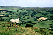
Sheep are a ubiquitous part of the moorland landscape. Their grazing helps to maintain the open wild landscape that is needed for many other plants and animals to thrive.
The limestone belt
Limestone weathers down quickly to produce nutrient rich alkaline soils on well drained rocks. Gouging by glacial meltwaters has left spectacular valleys along whose floors run attractive streams. The limestone streams with their nutrient rich waters support an abundance of aquatic invertebrates such as insect larvae and crustaceans. These in turn support such fish as troutTrout
Trout is the name for a number of species of freshwater and saltwater fish belonging to the Salmoninae subfamily of the family Salmonidae. Salmon belong to the same family as trout. Most salmon species spend almost all their lives in salt water...
and grayling
Grayling (species)
The grayling is a species of freshwater fish in the salmon family of order Salmoniformes. It is the type species of its genus. Native to the Palearctic ecozone, the grayling is widespread throughout northern Europe, from the United Kingdom and France to the Ural Mountains in Russia...
. Insects which emerge from the water in summer are also a rich source of food for birds. Grey wagtail
Grey Wagtail
The Grey Wagtail is a small member of the wagtail family, Motacillidae. The species looks similar to the Yellow Wagtail but has the yellow on its underside restricted to the throat and vent. Breeding males have a black throat...
s, swallows
Barn Swallow
The Barn Swallow is the most widespread species of swallow in the world. It is a distinctive passerine bird with blue upperparts, a long, deeply forked tail and curved, pointed wings. It is found in Europe, Asia, Africa and the Americas...
and spotted flycatcher
Spotted Flycatcher
The Spotted Flycatcher, Muscicapa striata, is a small passerine bird in the Old World flycatcher family. It breeds in most of Europe and western Asia, and is migratory, wintering in Africa and south western Asia. It is declining in parts of its range....
s are commonly seen. Dipper
White-throated Dipper
The White-throated Dipper , also known as the European Dipper or just Dipper is an aquatic passerine bird found in Europe, Middle East, Central Asia and the Indian Subcontinent. The species is divided into several subspecies, based primarily on colour differences, particularly of the pectoral band...
s and kingfishers are also typical. The otter
European Otter
The European Otter , also known as the Eurasian otter, Eurasian river otter, common otter and Old World otter, is a European and Asian member of the Lutrinae or otter subfamily, and is typical of freshwater otters....
, after a period of decline, is starting to recolonise the rivers and streams.
Farndale is famous for its wild daffodils in spring. Sheltered woodlands dominated by sessile oak
Sessile Oak
Quercus petraea , the Sessile Oak, also known as the Durmast Oak, is a species of oak native to most of Europe, and into Anatolia.-Description:...
s can be found to the south of the high ground. These woodland areas are the home of pied flycatchers, sparrow hawks and wood warbler
Wood Warbler
The Wood Warbler is a common and widespread leaf warbler which breeds throughout northern and temperate Europe, and just into the extreme west of Asia in the southern Ural Mountains...
s. Roe and fallow deer
Fallow Deer
The Fallow Deer is a ruminant mammal belonging to the family Cervidae. This common species is native to western Eurasia, but has been introduced widely elsewhere. It often includes the rarer Persian Fallow Deer as a subspecies , while others treat it as an entirely different species The Fallow...
can also be found here. The woodlands and south facing grasslands on the limestone belt provide a good habitat for many butterflies.
The fertile alkaline soils support an abundance of wild flowers. Bluebell
Common Bluebell
Hyacinthoides non-scripta, commonly known as the common bluebell, is a spring-flowering bulbous perennial plant. -Taxonomy:...
s and primrose
Primula vulgaris
Primula vulgaris is a species of Primula native to western and southern Europe , northwest Africa , and southwest Asia...
s grow in the hedgerows in spring and rarer plants such as the wood vetch and orchids are also to be found.
Adder
Vipera berus
Vipera berus, the common European adder or common European viper, is a venomous viper species that is extremely widespread and can be found throughout most of Western Europe and all the way to Far East Asia. Known by a host of common names including Common adder and Common viper, adders have been...
s are widespread throughout the national park. On the moors they eat common lizards and around the hedgerows and woodland edges they feed on mice and voles.
The Limestone grasslands support a wide variety of wild flowers, and many rarer butterflies can be seen. Pearl-bordered Fritillary
Pearl-bordered Fritillary
The Pearl-bordered Fritillary is a butterfly of the Nymphalidae family.It is orange with black spots on the upperside of its wing and has a wingspan of 38–46 mm. On the underside of the wings there is a row of silver pearly markings along the edge, which give the species its name...
, Duke of Burgundy Fritillary, Marbled White, Dingy Skipper
Dingy Skipper
The Dingy Skipper, Erynnis tages, is a butterfly of the Hesperiidae family. It ranges from Europe across Asia Minor and Central Asia to the Amur region.Erynnis tages favours open grassy habitats up to 2,000 metres above sea level...
and Grayling
Grayling
-Fish:*Grayling , Thymallus thymallus*Grayling , generically, any fish of the genus Thymallus in the family Salmonidae*Australian grayling , a fish in the family Retropinnidae...
are just some of species that inhabit the national park.
The coast
The cliffs and sandy bays of the coast offer an assortment of seashore habitats. The spectacular scenery where the Cleveland Hills meet the sea has been designated as a Heritage CoastHeritage Coast
A Heritage Coast is a strip of UK coastline designated by the Countryside Agency in England and the Countryside Council for Wales as having notable natural beauty or scientific significance.- Designated coastline :...
. The cliff at Boulby, at 690 feet (210.3 m), is the highest point on the east coast of England. Here the Jurassic strata of shales, clays and ironstones are displayed with superb clarity. There are also fine exposures of Jurassic rocks with their characteristic fossils around Robin Hoods Bay and Ravenscar.
Rocky shores offer an abundance of seaweeds in zones of different types which are more and less tolerant of exposure to the air and salt or clear water. Rock pools contain sea anemone
Sea anemone
Sea anemones are a group of water-dwelling, predatory animals of the order Actiniaria; they are named after the anemone, a terrestrial flower. Sea anemones are classified in the phylum Cnidaria, class Anthozoa, subclass Zoantharia. Anthozoa often have large polyps that allow for digestion of larger...
s, blennies, crab
Crab
True crabs are decapod crustaceans of the infraorder Brachyura, which typically have a very short projecting "tail" , or where the reduced abdomen is entirely hidden under the thorax...
s and molluscs.
Sandy shores harbour a variety of plants and animals which are buried in the sand. Birds such as curlews
Eurasian Curlew
The Eurasian Curlew, Numenius arquata, is a wader in the large family Scolopacidae. It is one of the most widespread of the curlews, breeding across temperate Europe and Asia...
and oyster catcher
Eurasian Oystercatcher
The Eurasian Oystercatcher Haematopus ostralegus, also known as the Common Pied Oystercatcher, or just Oystercatcher, is a wader in the oystercatcher bird family Haematopodidae. It is the most widespread of the oystercatchers, with three races breeding in western Europe, central Eurasia,...
s are to be seen prodding the sand to find these creatures for food. A few cormorant
Great Cormorant
The Great Cormorant , known as the Great Black Cormorant across the Northern Hemisphere, the Black Cormorant in Australia and the Black Shag further south in New Zealand, is a widespread member of the cormorant family of seabirds...
s and fulmar
Northern Fulmar
The Northern Fulmar, Fulmarus glacialis, Fulmar, or Arctic Fulmar is a highly abundant sea bird found primarily in subarctic regions of the north Atlantic and north Pacific oceans. Fulmars come in one of two color morphs: a light one which is almost entirely white, and a dark one which is...
s breed along the coast where stonechat
European Stonechat
The European Stonechat is a small passerine bird that was formerly classed as a subspecies of the Common Stonechat. Long considered a member of the thrush family Turdidae, genetic evidence has placed it and its relatives in the Old World flycatcher family Muscicapidae.It is 11.5–13 cm long and...
s and rock pipit
Rock Pipit
The Rock Pipit, Anthus petrosus, is a small passerine bird species which breeds on rocky coasts of western Europe northwards from Brittany. It is mainly resident in Ireland, Great Britain and France, in the west of its range, but the Scandinavian and Russian populations migrate south in winter;...
s can also be spotted. Herring gulls are the commonest breeding birds and are an interesting sight nesting in the chimneys of coastal towns.
History
There are records of 12,000 archaeological sites and features in the North York Moors National Park of which 700 are scheduled ancient monumentScheduled Ancient Monument
In the United Kingdom, a scheduled monument is a 'nationally important' archaeological site or historic building, given protection against unauthorized change. The various pieces of legislation used for legally protecting heritage assets from damage and destruction are grouped under the term...
s. Radio carbon dating of pollen grains preserved in the moorland peat provides a record of the actual species of plants that existed at various periods in the past.
About 10,000 years ago the cold climate of the ice age ameliorated and temperatures rose above growing point of 5.5 °C.Plant life was gradually re-established and animals and humans also returned.
Mesolithic
Around 8,000BC Britain was still part of the European land mass and communities of Middle Stone Age people migrated to England and began to inhabit the North York Moors. Relics of this early hunting, gathering and fishing community have been found as a widespread scattering of flint tools and the barbed flint flakes used in arrows and spears.Neolithic
By 5000 BC global sea levels had risen, the North Sea existed and Britain was cut off from mainland Europe. During the New Stone Age, which lasted from around 4500 to 2000 BC, the population increased and agriculture was adopted. These early farmers were the first to destroy the forest cover of the moors. Their settlements were concentrated in the fertile parts of the limestone belt and these areas have been continuously farmed ever since. The Neolithic farmers grew crops, kept animals, made pottery and were highly skilled at making stone implements. They buried their dead in long low burial mounds.Bronze Age
Around 2000 BC the early Bronze Age Beaker People were inhabiting the area. During a 1,400 year period these people inhabited all areas of the moors and finally destroyed much of the original forest. The climate was relatively warmer and drier at this time so it was possible to live on the high moors throughout the year. When a piece of land was exhausted of nutrients, these people moved on, leaving behind land that was incapable of supporting anything but a heathland vegetation. There are about 3,000 Bronze Age burial mounds on the moors.Iron Age
The Iron Age dates from about 600 BC. There are remains of two promontory hillforts at Boltby Scar and Rudston Scar and a collection of circular stone hut foundations on Percy Rigg. Other evidence of Iron Age occupation is scarce, having been obliterated by subsequent agricultural activity.Roman
By AD 71 the Roman army had reached Yorkshire where they established a fort at Malton. From here a number of roads radiated. One of these roads was Wades Causeway, which led north-eastwards over the Vale of Pickering and across the moors to the North Sea coast. There are Roman camps at Cawthorn and Lease Rigg near Grosmont and there are signal stations along the coast at Filey, Scarborough, Ravenscar, Goldsborough and Hunt Cliff. The Romans left Britain in AD 410.Anglo-Saxon and Viking
After the departure of the Romans, Germanic tribes arrived and settled in the area. These Angles, Saxons and Jutes gave many of the place names to villages on the moors They worshipped a number of gods, notably WodenWoden
Woden or Wodan is a major deity of Anglo-Saxon and Continental Germanic polytheism. Together with his Norse counterpart Odin, Woden represents a development of the Proto-Germanic god *Wōdanaz....
. However, Christianity came to Yorkshire when King Edwin of Northumbria was baptised in AD 627 at York. Christian monasteries were established at Lastingham in 654 and Whitby in 657. A nunnery was built at Hackness in 680.
In the ninth century Viking
Viking
The term Viking is customarily used to refer to the Norse explorers, warriors, merchants, and pirates who raided, traded, explored and settled in wide areas of Europe, Asia and the North Atlantic islands from the late 8th to the mid-11th century.These Norsemen used their famed longships to...
raiders began to attack the Yorkshire coast and in 867 these Danes destroyed the religious houses at Whitby, Lastingham and Hackness and after battle set up a new Danish kingdom based at York. The Danes settled in the area and later themselves became Christian. They introduced their language, elements of which still remain in the local dialect, and renamed a number of settlements.
The Middle Ages
King William I of England and his Norman barons took control of the nation in 1066. Central to the imposition of Norman rule was the building of castles. There are well-preserved castle ruins at Helmsley, Pickering and Scarborough and others existed at Ayton, Danby, Mulgrave and Whorlton. In the eleventh and twelfth centuries monasteries were established on the moors at Whitby AbbeyWhitby Abbey
Whitby Abbey is a ruined Benedictine abbey overlooking the North Sea on the East Cliff above Whitby in North Yorkshire, England. It was disestablished during the Dissolution of the Monasteries under the auspices of Henry VIII...
, Rievaulx Abbey
Rievaulx Abbey
Rievaulx Abbey is a former Cistercian abbey headed by the Abbot of Rievaulx. It is located in Rievaulx , near Helmsley in North Yorkshire, England.It was one of the wealthiest abbeys in England and was dissolved by Henry VIII of England in 1538...
, Byland Abbey
Byland Abbey
Byland Abbey is a ruined abbey and a small village in the Ryedale district of North Yorkshire, England at .-History:It was founded as a Savigniac abbey in January 1135 and was absorbed by the Cistercian order in 1147. It wasn't an easy start for the community who had had to move five times before...
and Mount Grace Priory
Mount Grace Priory
Mount Grace Priory, in the parish of East Harlsey, North Yorkshire, England is today the best preserved and most accessible of the ten medieval Carthusian houses in England....
. Gifts of land and money were bestowed on these establishments and the monastic orders became notable landowners, eventually owning about a third of the land in the area. The abbeys managed their land as sheep farms and became very rich on the profits. They continued to take in land from the waste and what remained of the forest and in the process gave the moors the distinctive landscape that still remains. Being envious of the wealth of the monasteries, Henry VIII of England closed them down, and confiscated and sold off their property. This was bought by individual people, some rich but some who had been tenants of the monasteries, and became privately owned land.
Post-mediaeval
In many areas of the moors and their associated dales the settlements took the form of isolated farms and hamlets rather than villages. Very few had an open field system of agriculture so Enclosure Acts were rarer than in other parts of England. The seventeenth century saw a major acceleration in the reclaiming of marginal waste land and in the eighteenth century forward looking landlords attempted to improve their lands using drainage schemes and fertilisation measures.The 19th century
In the 19th century railways were built from Pickering to Whitby (1836), Middlesbrough to Whitby (1868) and Scarborough to Whitby (1884).Locally sourced iron ore has been processed on the North York Moors from medieval times. In the 19th century it became a boom industry. Dozens of ironstone mines and several short-lived blast furnaces were constructed. Between 1856 and 1926 high-grade magnetic ironstone was mined in Rosedale. A railway was built around the top of the dale to serve the mines, and kilns were built to process the ore. In two decades the population of the valley rose from 558 to nearly 3000.Poor-quality coal
Coal
Coal is a combustible black or brownish-black sedimentary rock usually occurring in rock strata in layers or veins called coal beds or coal seams. The harder forms, such as anthracite coal, can be regarded as metamorphic rock because of later exposure to elevated temperature and pressure...
was mined in many places on the moors from the 18th century to the early 20th century.
The North York Moors is the only source for British jet
Jet (lignite)
Jet is a geological material and is considered to be a minor gemstone. Jet is not considered a true mineral, but rather a mineraloid as it has an organic origin, being derived from decaying wood under extreme pressure....
. It has been mined in the area from prehistoric times but the industry grew in the middle of the 19th century in response to a fashion for the jewellery produced from it. In the 1880s cheap imports produced a decline in the industry which was focused on Whitby. The remains of alum quarries are to be found to the north of the area and along the coast. Alum
Alum
Alum is both a specific chemical compound and a class of chemical compounds. The specific compound is the hydrated potassium aluminium sulfate with the formula KAl2.12H2O. The wider class of compounds known as alums have the related empirical formula, AB2.12H2O.-Chemical properties:Alums are...
was important to the textile industry because it was used as a mordant or fixative for dyes that were used to colour cloth. The industry thrived in the region from the early 17th century until 1871. Its decline came when chemical dyes were discovered. The scars of industrial activity on the moors make it an interesting area in which to pursue industrial archaeology.
Economy
Tourism
Tourism is travel for recreational, leisure or business purposes. The World Tourism Organization defines tourists as people "traveling to and staying in places outside their usual environment for not more than one consecutive year for leisure, business and other purposes".Tourism has become a...
and agriculture
Agriculture
Agriculture is the cultivation of animals, plants, fungi and other life forms for food, fiber, and other products used to sustain life. Agriculture was the key implement in the rise of sedentary human civilization, whereby farming of domesticated species created food surpluses that nurtured the...
.
Agriculture
For over a thousand years the basis of the economy in the North York Moors was agriculture. The rural scene, which attracts millions of visitors to the park each year, has been formed and maintained by generations of farmers. The 1996 Agricultural Census recorded a total workforce of 2,913 employed on 1,342 working farms. Sheep and cattle provide the prime source of farm income. The dale farms have rights to graze sheep on the open moor. The rights to moorland grazing are often essential to the economic viability of a farm. In recent years agriculture in Britain has suffered economic setbacks and the viability of hill farmingHill farming
Hill farming is extensive farming in upland areas, primarily rearing sheep, although historically cattle was often reared more intensively.Cattle farming is usually restricted by a scarcity of winter fodder, and sheep stocks, grazing at about 2 hectares per head, are often taken to lowland areas...
has become questionable. A number of environmental schemes to improve farm incomes have been devised but the industry continues to decline.
Agricultural use of the moors is shared with grouse shooting as a means of gaining financial return from the vast expanse of heather. There is richer farmland across the southern limestone belt, where there are arable and mixed farms as well as the livestock farms. The main arable crops are barley, wheat, oilseed rape, potatoes, and sugar beets. There is also some intensive production of pigs and poultry.
Tourism
Many visitors to the moors are engaged in outdoor pursuits, particularly walkingHillwalking
In the British Isles, the terms hillwalking or fellwalking are commonly used to describe the recreational outdoor activity of walking on hills and mountains, often with the intention of visiting their summits...
; the parks have a network of rights-of-way almost 2300 km (1400 miles) in length, and most of the areas of open moorland will be open access under the Countryside and Rights of Way Act 2000
Countryside and Rights of Way Act 2000
The Countryside and Rights of Way Act 2000 is a UK Act of Parliament which came into force on 30 November 2000.As of September 2007, not all sections of the Countryside and Rights of Way Act have yet come into force...
. Popular named walks include the Cleveland Way
Cleveland Way
The Cleveland Way is a National Trail in ancient Cleveland in Northern England. It runs 110 miles from Helmsley to Filey, skirting the North York Moors National Park.-History:The trail was opened in 1969...
, which circles the moors, and has a section along the coast; and the Lyke Wake Walk
Lyke Wake Walk
The Lyke Wake Walk was started by a local farmer, Bill Cowley, in the North Riding of Yorkshire, England, in 1955. He claimed that one could walk over the North York Moors from east to west on heather all the way except for crossing one or two roads and he issued a challenge that walkers took up...
, which leads directly across the heart of the moors. The area also offers opportunities for cycling
Cycling
Cycling, also called bicycling or biking, is the use of bicycles for transport, recreation, or for sport. Persons engaged in cycling are cyclists or bicyclists...
, mountain biking
Mountain biking
Mountain biking is a sport which consists of riding bicycles off-road, often over rough terrain, using specially adapted mountain bikes. Mountain bikes share similarities with other bikes, but incorporate features designed to enhance durability and performance in rough terrain.Mountain biking can...
, and horse-riding, including a circular long distance bridleroute created around the North York Moors which can be accessed at a number of locations. The steep escarpments that define the edges of the park on three sides are used by several gliding
Gliding
Gliding is a recreational activity and competitive air sport in which pilots fly unpowered aircraft known as gliders or sailplanes using naturally occurring currents of rising air in the atmosphere to remain airborne. The word soaring is also used for the sport.Gliding as a sport began in the 1920s...
clubs.
Entertainment
The moors have not changed much in the past 50 years, and are often used as a backdrop to British televisionTelevision
Television is a telecommunication medium for transmitting and receiving moving images that can be monochrome or colored, with accompanying sound...
programmes and films.The series Heartbeat and the scenes of The Hogsmeade Station in the Harry Potter movies were filmed in Goathland
Goathland
Goathland is a village and civil parish in the Scarborough district of North Yorkshire, England. It is in the North York Moors national park situated due north of Pickering, off the A169 to Whitby...
. Dalby Forest
Dalby Forest
Dalby Forest is a forest located on the southern slopes of the North York Moors National Park in North Yorkshire, England. It is maintained by the UK Forestry Commission...
is also host to many forms of entertainment throughout the year including outdoor concerts.
Towns
There are few major settlements within, or around, the National Park: HelmsleyHelmsley
Helmsley is a market town and civil parish in the Ryedale district of North Yorkshire, England. The town is located at the point where the valleys of Bilsdale and Ryedale leave the higher moorland and join the flat Vale of Pickering. It is situated on the River Rye and lies on the A170 road, east...
, Pickering
Pickering, North Yorkshire
Pickering is an ancient market town and civil parish in the Ryedale district of the county of North Yorkshire, England, on the border of the North York Moors National Park. It sits at the foot of the Moors, overlooking the Vale of Pickering to the south...
, Kirkbymoorside
Kirkbymoorside
Kirkbymoorside is a small market town and civil parish in the Ryedale district of North Yorkshire, England which lies approximately 25 miles north of York midway between Pickering and Helmsley, and has a population of approximately 3,000.-History:...
, Guisborough
Guisborough
Guisborough is a market town and civil parish within the unitary authority of Redcar and Cleveland and the ceremonial county of North Yorkshire, England....
, Stokesley
Stokesley
Stokesley is a small market town and civil parish in the Hambleton district of North Yorkshire, England. It lies on the River Leven. Stokesley is located about two miles south of the boundary of the borough of Middlesbrough and ten miles south of Middlesbrough town centre. Stokesley is located...
, Northallerton
Northallerton
Northallerton is an affluent market town and civil parish in the Hambleton district of North Yorkshire, England. It lies in the Vale of Mowbray and at the northern end of the Vale of York. It has a population of 15,741 according to the 2001 census...
and Whitby
Whitby
Whitby is a seaside town, port and civil parish in the Scarborough borough of North Yorkshire, England. Situated on the east coast of Yorkshire at the mouth of the River Esk, Whitby has a combined maritime, mineral and tourist heritage, and is home to the ruins of Whitby Abbey where Caedmon, the...
. The moors are within a reasonable distance of Redcar
Redcar
Redcar is a seaside resort in the north east of England, and a major town in the unitary authority of Redcar and Cleveland in the ceremonial county of North Yorkshire. It lies east-northeast of Middlesbrough by the North Sea coast...
and form part of East Cleveland. The moors are also within 20 minutes driving time from central Middlesbrough
Middlesbrough
Middlesbrough is a large town situated on the south bank of the River Tees in north east England, that sits within the ceremonial county of North Yorkshire...
and Scarborough.
- KilburnKilburn, North YorkshireKilburn is a small village in North Yorkshire, England that is known for two reasons: the White Horse, and the Mouseman.The White Horse is a figure cut into the hillside to the north of the village, and visible for many miles around on a clear day....
- CastletonCastleton, North YorkshireCastleton is a village on the River Esk, part of the civil parish of Danby in the county of North Yorkshire in England. It can be found about 15 miles south-east of Middlesbrough, in the North York Moors. There was once a medieval castle sited on Castle Hill....
- GoathlandGoathlandGoathland is a village and civil parish in the Scarborough district of North Yorkshire, England. It is in the North York Moors national park situated due north of Pickering, off the A169 to Whitby...
- Grosmont
- HelmsleyHelmsleyHelmsley is a market town and civil parish in the Ryedale district of North Yorkshire, England. The town is located at the point where the valleys of Bilsdale and Ryedale leave the higher moorland and join the flat Vale of Pickering. It is situated on the River Rye and lies on the A170 road, east...
- Hutton-le-HoleHutton-le-HoleHutton-le-Hole is a very small village and civil parish in the Ryedale district of North Yorkshire, England, about seven miles north west of Pickering. Hutton-le-Hole is a honeypot village...
- KirkbymoorsideKirkbymoorsideKirkbymoorside is a small market town and civil parish in the Ryedale district of North Yorkshire, England which lies approximately 25 miles north of York midway between Pickering and Helmsley, and has a population of approximately 3,000.-History:...
- Osmotherley
- PickeringPickering, North YorkshirePickering is an ancient market town and civil parish in the Ryedale district of the county of North Yorkshire, England, on the border of the North York Moors National Park. It sits at the foot of the Moors, overlooking the Vale of Pickering to the south...
- Robin Hood's BayRobin Hood's BayRobin Hood’s Bay is a small fishing village and a bay located five miles south of Whitby and 15 miles north of Scarborough on the coast of North Yorkshire, England. Bay Town, its local name, is in the ancient chapelry of Fylingdales in the wapentake of Whitby Strand.-Toponymy:The origin of the name...
- WhitbyWhitbyWhitby is a seaside town, port and civil parish in the Scarborough borough of North Yorkshire, England. Situated on the east coast of Yorkshire at the mouth of the River Esk, Whitby has a combined maritime, mineral and tourist heritage, and is home to the ruins of Whitby Abbey where Caedmon, the...
- SwainbySwainbySwainby is a village in the Hambleton district of North Yorkshire, England. It is 8 miles north east of Northallerton on the A172. The small market town of Stokesley is only 5 miles away....
Attractions
- North Yorkshire Moors RailwayNorth Yorkshire Moors RailwayThe North Yorkshire Moors Railway is a heritage railway in North Yorkshire, England. First opened in 1836 as the Whitby and Pickering Railway, the railway was planned in 1831 by George Stephenson as a means of opening up trade routes inland from the then important seaport of Whitby. The line...
- Byland AbbeyByland AbbeyByland Abbey is a ruined abbey and a small village in the Ryedale district of North Yorkshire, England at .-History:It was founded as a Savigniac abbey in January 1135 and was absorbed by the Cistercian order in 1147. It wasn't an easy start for the community who had had to move five times before...
- Cleveland WayCleveland WayThe Cleveland Way is a National Trail in ancient Cleveland in Northern England. It runs 110 miles from Helmsley to Filey, skirting the North York Moors National Park.-History:The trail was opened in 1969...
National trail (long distance footpath) - Lyke Wake WalkLyke Wake WalkThe Lyke Wake Walk was started by a local farmer, Bill Cowley, in the North Riding of Yorkshire, England, in 1955. He claimed that one could walk over the North York Moors from east to west on heather all the way except for crossing one or two roads and he issued a challenge that walkers took up...
(long distance footpath) - Forge ValleyForge ValleyForge Valley is a nature reserve on the East Ayton / Hackness road. The valley follows the route of the River Derwent and was formed by melting ice water at the end of the last ice age....
NNR National Nature ReserveNational Nature ReserveFor details of National nature reserves in the United Kingdom see:*National Nature Reserves in England*National Nature Reserves in Northern Ireland*National Nature Reserves in Scotland*National Nature Reserves in Wales... - Farndale LNRFarndaleFarndale is a valley located in the North York Moors National Park in North Yorkshire, England. The nearest town is Kirkbymoorside located some 5 miles to the south. Pickering is some 13 miles to the south east and Helmsley 12 miles to the south west. Farndale is surrounded by some of the most...
Local Nature ReserveLocal Nature ReserveLocal nature reserve or LNR is a designation for nature reserves in the United Kingdom. The designation has its origin in the recommendations of the Wild Life Conservation Special Committee which established the framework for nature conservation in the United Kingdom and suggested a national suite... - Helmsley CastleHelmsley CastleHelmsley Castle is a medieval castle situated in the market town of Helmsley, North Yorkshire, England.-History:...
- Yorkshire Wildlife TrustYorkshire Wildlife TrustThe Yorkshire Wildlife Trust is a wildlife trust covering the traditional county of Yorkshire, England.The Trust is part of the UK-wide partnership of 47 Wildlife Trusts.It was formed in 1946, as the Yorkshire Naturalists’ Trust, essentially to preserve its first nature reserve Askham Bog on the...
Reserves: Ashberry Pastures, Bridestones, Ellerburn Bank, Fen Bog, Garbutt Wood, Hagg wood Marsh, Hayburn Wyke, LittlebeckLittlebeck, North YorkshireLittlebeck is a hamlet, near Whitby, in North Yorkshire, England. It stands on the Little Beck - a minor tributary of the River Esk.The hamlet is located in the bottom of a deep valley, with road names such as "Blue Bank", "Goathland Banks" and "Lousy Hill Lane" giving an indication of the local...
. - Rievaulx AbbeyRievaulx AbbeyRievaulx Abbey is a former Cistercian abbey headed by the Abbot of Rievaulx. It is located in Rievaulx , near Helmsley in North Yorkshire, England.It was one of the wealthiest abbeys in England and was dissolved by Henry VIII of England in 1538...
- River SevenRiver SevenThe River Seven is a river in North Yorkshire, England.The River Seven rises on Danby High Moor, in the middle of the North York Moors, and flows south for about 15 miles or 25 km to meet the River Rye, at Brawby....
, River DoveRiver Dove, North YorkshireThe River Dove is a river the county of North Yorkshire, England, and is a tributary of the River Rye, itself a tributary of the River Derwent. It is the drainage basin of the moorland of Farndale, Stocksdale, Baysdale, Greenhow and Westerdale. It is formed by the confluence of Blakey Gill and West...
, River RyeRiver Rye, YorkshireThe River Rye is a river in the English county of North Yorkshire. It rises just south of the Cleveland Hills, east of Osmotherley, and flows through Hawnby, Rievaulx, Helmsley, Nunnington, West and East Ness, Butterwick, Brawby, and Ryton, before joining the River Derwent at near Malton.On some...
, River Seph, River Esk - Rosedale AbbeyRosedale AbbeyRosedale Abbey is a village located in a spectacular valley in the centre of Rosedale, North Yorkshire, England, midway between Pickering and Castleton in an area of rolling hillsides and stunning scenery...
- Flamingo Land Theme Park and ZooFlamingo Land Theme Park and ZooFlamingo Land is a theme park and resort located in North Yorkshire, England. It attracts about 1.8 million visitors per year. Flamingo Land is also the 12th most visited theme park in Europe.Some of the major attractions at Flamingo Land include:...
- Eden Camp MuseumEden Camp MuseumEden Camp Modern History Theme Museum is a large Second World War-related museum near Malton in North Yorkshire in England.It occupies a former Second World War prisoner-of-war camp of 33 huts. After the prisoners left, the camp was used for storage and then abandoned. Its grounds then became...