

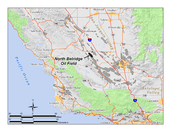
North Belridge Oil Field
Encyclopedia
Oil field
An oil field is a region with an abundance of oil wells extracting petroleum from below ground. Because the oil reservoirs typically extend over a large area, possibly several hundred kilometres across, full exploitation entails multiple wells scattered across the area...
along California State Route 33
California State Route 33
State Route 33 is a north–south state highway in the U.S. state of California. SR 33 replaced part of U.S. Route 399 in 1964 during the "great renumbering" of routes. In the unincorporated sections of Kern County it is known as the West Side Highway...
in the northwestern portion of Kern County, California
Kern County, California
Spreading across the southern end of the California Central Valley, Kern County is the fifth-largest county by population in California. Its economy is heavily linked to agriculture and to petroleum extraction, and there is a strong aviation and space presence. Politically, it has generally...
, about 45 miles west of Bakersfield
Bakersfield, California
Bakersfield is a city near the southern end of the San Joaquin Valley in Kern County, California. It is roughly equidistant between Fresno and Los Angeles, to the north and south respectively....
. It is contiguous with the larger South Belridge Oil Field
South Belridge Oil Field
The South Belridge Oil Field is a large oil field in northwestern Kern County, San Joaquin Valley, California, about forty miles west of Bakersfield...
to the southeast, in a region of highly productive and mature fields. Discovered in 1912, it has had a cumulative production of 136,553,000 barrels of oil, and retains 27,443,000 barrels in reserve, as of the end of 2006, making it the 40th largest oil field in the state.
Setting
The oil field is located along the west side of State Route 33California State Route 33
State Route 33 is a north–south state highway in the U.S. state of California. SR 33 replaced part of U.S. Route 399 in 1964 during the "great renumbering" of routes. In the unincorporated sections of Kern County it is known as the West Side Highway...
, beginning about four miles south of its junction with State Route 46
California State Route 46
State Route 46 is an east–west state highway in the U.S. state of California. It is a major crossing of the Coast Ranges, connecting SR 1 on the Central Coast near Cambria and US 101 in Paso Robles with SR 99 at Famoso in the San Joaquin Valley. East of Paso Robles, where it carried U.S...
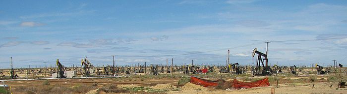
. It is about five miles long by one mile across, paralleling the highway on the southwest. The low Antelope Hills run adjacent to the field on the southwest, and the entire area slopes gently down to the northeast, towards the San Joaquin Valley; agricultural fields and orchards begin on the other side of Highway 33 from the field. Elevations on the field range from about 600 to 700 feet above sea level, while the floor of the valley to the northeast is around 250 feet. The main production area of the field is almost completely flat.
The North Belridge Oil Field is part of a the larger Belridge Producing Complex of Aera Energy LLC, which includes also the much larger oil fields of South Belridge
South Belridge Oil Field
The South Belridge Oil Field is a large oil field in northwestern Kern County, San Joaquin Valley, California, about forty miles west of Bakersfield...
, Lost Hills
Lost Hills Oil Field
The Lost Hills Oil Field is a large oil field in the Lost Hills Range, north of the town of Lost Hills in western Kern County, California, in the United States.-Production:...
, and Cymric
Cymric Oil Field
The Cymric Oil Field is a large oil field in Kern County, California in the United States. While only the 14th-largest oil field in California in total size, in terms of total remaining reserves it ranks fifth, with the equivalent of over still in the ground...
, all in northwestern Kern County. Other nearby oil fields include the small Antelope Hills and McDonald Anticline fields several miles to the southwest, and the large Lost Hills Oil Field
Lost Hills Oil Field
The Lost Hills Oil Field is a large oil field in the Lost Hills Range, north of the town of Lost Hills in western Kern County, California, in the United States.-Production:...
to the northeast, adjacent to the town of Lost Hills
Lost Hills, California
Lost Hills is a census-designated place in Kern County, California, United States. Lost Hills is located west-northwest of Bakersfield, at an elevation of 305 feet...
.
The climate in the North Belridge area is arid to semi-arid, with an average annual rainfall of five to six inches (152 mm), almost all in the winter months. Temperatures in the summer routinely top 100 degrees Fahrenheit; occasional freezes occur in the winter. Native vegetation in the vicinity of the field is mostly grassland and sparse scrub, although most of the vegetation has been removed from the area of most active operations, with the land in these central areas now almost completely barren except for oil rigs, drilling pads, and associated equipment.
Geology
The North Belridge Field, like the South Belridge and the others nearby (CymricCymric Oil Field
The Cymric Oil Field is a large oil field in Kern County, California in the United States. While only the 14th-largest oil field in California in total size, in terms of total remaining reserves it ranks fifth, with the equivalent of over still in the ground...
, Monument Junction, McKittrick
McKittrick Oil Field
The McKittrick Oil Field is a large oil and gas field in western Kern County, California. The town of McKittrick overlies the northeastern portion of the oil field...
, Antelope Hills, and others) is near the western margin of the huge San Joaquin Basin,a region of extensive sedimentary rocks of varying porosity and permeability, containing anticlinal folds and copious quantities of petroleum, much of which has been extracted in the early and middle 20th century. The San Andreas Fault
San Andreas Fault
The San Andreas Fault is a continental strike-slip fault that runs a length of roughly through California in the United States. The fault's motion is right-lateral strike-slip...
, the boundary of the Pacific and North American plates, borders the basin on the west; it is about ten miles from the North Belridge Field, on the other side of the Temblor Range
Temblor Range
The Temblor Range is a mountain range within the California Coast Ranges, at the southwestern extremity of the San Joaquin Valley in California in the United States. It runs in a northwest-southeasterly direction along the borders of Kern County and San Luis Obispo County. The name of the range is...
.
In the North Belridge Field, most oil is trapped in anticlinal
Anticline
In structural geology, an anticline is a fold that is convex up and has its oldest beds at its core. The term is not to be confused with antiform, which is a purely descriptive term for any fold that is convex up. Therefore if age relationships In structural geology, an anticline is a fold that is...
formations. There are eight separate pools within the field. The following list gives them in order by depth from top to bottom, along with the year of discovery for each:
- Tulare-Etchegoin (1917)
- Diatomite (1978)
- Fractured Shale (1912)
- Temblor Sand (1930)
- Carneros (1966)
- R Sand (1939)
- Bloemer/Belridge 64/Gibson (1932)
- Y Sand (1942)
The age range of the pools and their corresponding geologic formations is from Pliocene
Pliocene
The Pliocene Epoch is the period in the geologic timescale that extends from 5.332 million to 2.588 million years before present. It is the second and youngest epoch of the Neogene Period in the Cenozoic Era. The Pliocene follows the Miocene Epoch and is followed by the Pleistocene Epoch...
-Miocene
Miocene
The Miocene is a geological epoch of the Neogene Period and extends from about . The Miocene was named by Sir Charles Lyell. Its name comes from the Greek words and and means "less recent" because it has 18% fewer modern sea invertebrates than the Pliocene. The Miocene follows the Oligocene...
for the uppermost members, to Eocene
Eocene
The Eocene Epoch, lasting from about 56 to 34 million years ago , is a major division of the geologic timescale and the second epoch of the Paleogene Period in the Cenozoic Era. The Eocene spans the time from the end of the Palaeocene Epoch to the beginning of the Oligocene Epoch. The start of the...
for the oceanic Y Sand, which is at a depth of over 8500 feet. The fourth pool – the Temblor Sand – is within the Monterey Formation
Monterey Formation
The Monterey Formation is an extensive Miocene oil-rich geological sedimentary formation in California, with massive outcroppings of the formation in areas of the California Coast Ranges, Peninsular Ranges, and on some of California's off-shore islands...
, the wide-ranging unit throughout much of coastal California which is the probable source rock
Source rock
In petroleum geology, source rock refers to rocks from which hydrocarbons have been generated or are capable of being generated. They form one of the necessary elements of a working petroleum system. They are organic-rich sediments that may have been deposited in a variety of environments including...
for much of the state's oil. The Oligocene portions of the stratigraphy, including the Bloemer/Belridge 64/Gibson pools, are an old submarine fan, cut off from its source units by movement of the plates along the San Andreas Fault.
Oil viscosity and quality from the field is widely variable. Greka's
Greka Energy
Greka Energy, currently also known as HVI Cat Canyon Inc. is a private United States oil and gas company operating principally in southern and central California, centered on Santa Barbara County...
lease produces mostly heavy oil, with an API of around 13 and a high sulfur content, which it uses either as feedstock for its asphalt refinery in Santa Maria (when the price of oil is low) or sells on the open market (when the price is high). Some of the pools produce light oil with an API as high as 52, for example the "R Sand", at which production peaked in 1951.
History, production, and operations
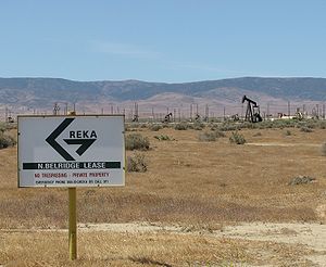
In 1979, Shell Oil acquired Belridge Oil Company, the long-time operator of the field, and maintained most of the production until 1997, at which time Aera Energy LLC, a joint venture of Shell and Mobil Oil Company, took over. However the North Belridge component of the giant field had several small independent operators, most of which have either left or have been acquired by larger companies. Current operators on the field as of 2008 include Aera Energy LLC
Aera Energy LLC
Aera Energy LLC is a natural gas, oil exploration and production company jointly owned by Shell and ExxonMobil headquartered in Bakersfield, California...
; American Energy Operations, Inc.; and Greka Energy
Greka Energy
Greka Energy, currently also known as HVI Cat Canyon Inc. is a private United States oil and gas company operating principally in southern and central California, centered on Santa Barbara County...
. In 2008 Aera was the largest operator, with approximately 1,300 active oil wells. American Energy had approximately 150, and Greka Energy 73. American Energy produces from the Dow Chanslor lease, which straddles the boundary between the North and South Belridge fields, while Greka maintains a group of production wells along Highway 33 in the northeast portion, in the Belridge, Gibson and McPhail leases.
Several enhanced recovery
Enhanced oil recovery
Enhanced Oil Recovery is a generic term for techniques for increasing the amount of crude oil that can be extracted from an oil field...
methods have been employed at the North Belridge Field, including cyclic steam
Steam injection (oil industry)
Steam injection is an increasingly common method of extracting heavy oil. It is considered an enhanced oil recovery method and is the main type of thermal stimulation of oil reservoirs. There are several different forms of the technology, with the two main ones being Cyclic Steam Stimulation and...
(the "huff and puff" method, on the heavy oil in the Tulare pool); steam flooding; gas injection (on the Temblor Sands and the Y Sand); and waterflooding.
Over 2,800 wells had been drilled on the field since its discovery in 1912.