

North American Monsoon
Encyclopedia
The North American monsoon, variously known as the Southwest United States monsoon
, the Mexican monsoon, or the Arizona monsoon, is experienced as a pronounced increase in rainfall from an extremely dry June to a rainy July over large areas of the southwestern United States
and northwestern Mexico
. These summer rains typically last until mid-September when a drier regime is reestablished over the region. Geographically, the NA monsoon precipitation region is centered over the Sierra Madre Occidental
in the Mexican states of Sinaloa
, Durango
, Sonora
and Chihuahua.
 The North American Monsoon is not as strong or persistent as its Indian counterpart, mainly because the Mexican Plateau
is not as high or as large as the Tibetan Plateau
in Asia. However, the North American Monsoon shares most of the basic characteristics of its Indian counterpart. There is a shift in wind patterns in summer which occurs as Mexico and the southwest U.S. warm under intense solar heating. As this happens, the flow reverses. The prevailing winds start to flow from moist ocean areas into dry land areas.
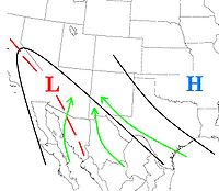
The North American monsoon is associated with an area of high pressure
called the subtropical ridge
that moves northward during the summer months and a thermal low
(a trough of low pressure which develops from intense surface heating) over the Mexican Plateau and the Desert Southwest of the United States. The monsoon begins in late May to early June in southern Mexico and quickly spreads along the western slopes of the Sierra Madre Occidental, reaching Arizona
and New Mexico
in early July. The monsoon extends into the southwest United States as it matures in mid July when an area of high pressure, called the monsoon or subtropical ridge, develops in the upper atmosphere over the Four Corners region, creating an easterly to southeasterly wind flow aloft.
Pulses of low level moisture are transported primarily from the Gulf of California
and eastern Pacific
. The Gulf of California, a narrow body of water surrounded by mountains, is particularly important for low-level moisture transport into Arizona and Sonora. Upper level moisture is also transported into the region, mainly from the Gulf of Mexico
by easterly winds aloft. Once the forests of the Sierra Madre Occidental green up from the initial monsoon rains, evaporation and plant transpiration
can add additional moisture to the atmosphere which will then flow into Arizona. Finally, if the southern Plains of the U.S. are unusually wet and green during the early summer months, that area can also serve as a moisture source.
As precipitable water values rise in early summer, brief but often torrential thunderstorms can occur, especially over mountainous terrain. This activity is occasionally enhanced by the passage of tropical waves and the entrainment
of the remnants of tropical cyclones.
Monsoons play a vital role in managing wildfire
threat by providing moisture at higher elevations and feeding desert streams. Heavy monsoon rain can lead to excess winter plant growth, in turn a summer wildfire risk. A lack of monsoon rain can hamper summer seeding, reducing excess winter plant growth but worsening drought.
Flash flood
ing is a serious danger during the monsoon season. Dry washes can become raging rivers in an instant, even when no storms are visible as a storm can cause a flash flood tens of miles away (never camp in a dry wash in the desert). Lightning strikes are also a significant danger. Because it is dangerous to be caught in the open when these storms suddenly appear, many golf courses in Arizona have thunderstorm warning systems.
The North American Monsoon circulation pattern typically develops in late May or early June over southwest Mexico. By mid to late summer, thunderstorm
s increase over the "core" region of the southwest U.S. and northwest Mexico, including the U.S. and Mexican states of Arizona, New Mexico, Sonora, Chihuahua, Sinaloa and Durango. The monsoon typically arrives in mid to late June over northwest Mexico, and early July over the southwest U.S. Once the monsoon is underway, mountain ranges, including the Sierra Madre Occidental and the Mogollon Rim provide a focusing mechanism for the daily development of thunderstorms. Thus much of the monsoon rainfall occurs in mountainous terrain. For example, monsoon rainfall in the Sierra Madre Occidental typically ranges from 10 to 15 inches. Since the southwest U.S. is at the northern fringe of the monsoon, precipitation is less and tends to be more variable. Areas further west of the core monsoon region, namely California and Baja California, typically receive only spotty monsoon-related rainfall. In those areas, the intense solar heating isn't strong enough to overcome a continual supply of cold water from the North Pacific Ocean moving down the west coast of North America. Winds do turn toward the land in these areas, but the cool moist air actually stabilizes the atmosphere. The monsoon pushes as far west as the Peninsular Ranges
and Transverse Ranges
of southern California, but rarely reaches the coastal strip. As shown in the panorama below, a wall of thunderstorms, only a half-hour's drive away, is a common sight from the sunny skies along the coast during the monsoon.
This monsoon ridge is almost as strong as the one which develops over Asia during the summer. However, since the lower level moisture flow is not as persistent as in the Indian monsoon, the upper level steering pattern and disturbances around the ridge are critical for influencing where thunderstorms develop on any given day. The exact strength and position of the subtropical ridge also governs how far north the tropical easterly winds aloft can spread. If the ridge is too close to a particular area, the sinking air at its center suppresses thunderstorms and can result in a significant monsoon "break." If the ridge is too far away or too weak, the east winds around the high are inadequate to bring tropical moisture into the mountains of Mexico and southwest U.S. However, if the ridge sets up in a few key locations, widespread and potentially severe thunderstorms can develop.
s which have very different spatial/temporal distribution characteristics. The difficulty in understanding the variability of summertime convective activity in the southwestern U.S. and northwestern Mexico results from the complex interactions between atmospheric circulation features at both the synoptic
(100 to 1000 km spatially, 1 day to 1 week, temporally) and mesoscale
(several km to 100 km, hours to one day temporally) and the extremely varied topography. The larger-scale atmospheric motions may control the distribution of water vapor and the general stability or instability (that is, the tendency to form storms) in the atmosphere; nevertheless, local topographic effects are critical to the geographic and even temporal distribution of convective activity.
Monsoon
Monsoon is traditionally defined as a seasonal reversing wind accompanied by corresponding changes in precipitation, but is now used to describe seasonal changes in atmospheric circulation and precipitation associated with the asymmetric heating of land and sea...
, the Mexican monsoon, or the Arizona monsoon, is experienced as a pronounced increase in rainfall from an extremely dry June to a rainy July over large areas of the southwestern United States
Southwestern United States
The Southwestern United States is a region defined in different ways by different sources. Broad definitions include nearly a quarter of the United States, including Arizona, California, Colorado, Nevada, New Mexico, Oklahoma, Texas and Utah...
and northwestern Mexico
Mexico
The United Mexican States , commonly known as Mexico , is a federal constitutional republic in North America. It is bordered on the north by the United States; on the south and west by the Pacific Ocean; on the southeast by Guatemala, Belize, and the Caribbean Sea; and on the east by the Gulf of...
. These summer rains typically last until mid-September when a drier regime is reestablished over the region. Geographically, the NA monsoon precipitation region is centered over the Sierra Madre Occidental
Sierra Madre Occidental
The Sierra Madre Occidental is a mountain range in western Mexico.-Setting:The range runs north to south, from just south of the Sonora–Arizona border southeast through eastern Sonora, western Chihuahua, Sinaloa, Durango, Zacatecas, Nayarit, Jalisco, Aguascalientes to Guanajuato, where it joins...
in the Mexican states of Sinaloa
Sinaloa
Sinaloa officially Estado Libre y Soberano de Sinaloa is one of the 31 states which, with the Federal District, comprise the 32 Federal Entities of Mexico. It is divided in 18 municipalities and its capital city is Culiacán Rosales....
, Durango
Durango
Durango officially Estado Libre y Soberano de Durango is one of the 31 states which, with the Federal District, comprise the 32 Federal Entities of Mexico. The state is located in Northwest Mexico. With a population of 1,632,934, it has Mexico's second-lowest population density, after Baja...
, Sonora
Sonora
Sonora officially Estado Libre y Soberano de Sonora is one of the 31 states which, with the Federal District, comprise the 32 Federal Entities of Mexico. It is divided into 72 municipalities; the capital city is Hermosillo....
and Chihuahua.
Causes and effects of North American Monsoon
Mexican Plateau
The Central Mexican Plateau, also known as the Mexican Altiplano or Altiplanicie Mexicana, is a large arid-to-semiarid plateau that occupies much of northern and central Mexico...
is not as high or as large as the Tibetan Plateau
Tibetan Plateau
The Tibetan Plateau , also known as the Qinghai–Tibetan Plateau is a vast, elevated plateau in Central Asia covering most of the Tibet Autonomous Region and Qinghai, in addition to smaller portions of western Sichuan, southwestern Gansu, and northern Yunnan in Western China and Ladakh in...
in Asia. However, the North American Monsoon shares most of the basic characteristics of its Indian counterpart. There is a shift in wind patterns in summer which occurs as Mexico and the southwest U.S. warm under intense solar heating. As this happens, the flow reverses. The prevailing winds start to flow from moist ocean areas into dry land areas.
The North American monsoon is associated with an area of high pressure
High pressure area
A high-pressure area is a region where the atmospheric pressure at the surface of the planet is greater than its surrounding environment. Winds within high-pressure areas flow outward due to the higher density air near their center and friction with land...
called the subtropical ridge
Subtropical ridge
The subtropical ridge is a significant belt of high pressure situated around the latitudes of 30°N in the Northern Hemisphere and 30°S in the Southern Hemisphere. It is characterized by mostly calm winds, which acts to reduce air quality under its axis by causing fog overnight, and haze during...
that moves northward during the summer months and a thermal low
Thermal low
Thermal lows, or heat lows, are non-frontal low-pressure areas that occur over the continents in the subtropics such as near the Sonoran Desert, the Mexican plateau, Sahara, South America over northwest Argentina, Australia, the Iberian peninsula, and Tibetan plateau during the warm season as the...
(a trough of low pressure which develops from intense surface heating) over the Mexican Plateau and the Desert Southwest of the United States. The monsoon begins in late May to early June in southern Mexico and quickly spreads along the western slopes of the Sierra Madre Occidental, reaching Arizona
Arizona
Arizona ; is a state located in the southwestern region of the United States. It is also part of the western United States and the mountain west. The capital and largest city is Phoenix...
and New Mexico
New Mexico
New Mexico is a state located in the southwest and western regions of the United States. New Mexico is also usually considered one of the Mountain States. With a population density of 16 per square mile, New Mexico is the sixth-most sparsely inhabited U.S...
in early July. The monsoon extends into the southwest United States as it matures in mid July when an area of high pressure, called the monsoon or subtropical ridge, develops in the upper atmosphere over the Four Corners region, creating an easterly to southeasterly wind flow aloft.
Pulses of low level moisture are transported primarily from the Gulf of California
Gulf of California
The Gulf of California is a body of water that separates the Baja California Peninsula from the Mexican mainland...
and eastern Pacific
Pacific Ocean
The Pacific Ocean is the largest of the Earth's oceanic divisions. It extends from the Arctic in the north to the Southern Ocean in the south, bounded by Asia and Australia in the west, and the Americas in the east.At 165.2 million square kilometres in area, this largest division of the World...
. The Gulf of California, a narrow body of water surrounded by mountains, is particularly important for low-level moisture transport into Arizona and Sonora. Upper level moisture is also transported into the region, mainly from the Gulf of Mexico
Gulf of Mexico
The Gulf of Mexico is a partially landlocked ocean basin largely surrounded by the North American continent and the island of Cuba. It is bounded on the northeast, north and northwest by the Gulf Coast of the United States, on the southwest and south by Mexico, and on the southeast by Cuba. In...
by easterly winds aloft. Once the forests of the Sierra Madre Occidental green up from the initial monsoon rains, evaporation and plant transpiration
Evapotranspiration
Evapotranspiration is a term used to describe the sum of evaporation and plant transpiration from the Earth's land surface to atmosphere. Evaporation accounts for the movement of water to the air from sources such as the soil, canopy interception, and waterbodies...
can add additional moisture to the atmosphere which will then flow into Arizona. Finally, if the southern Plains of the U.S. are unusually wet and green during the early summer months, that area can also serve as a moisture source.
As precipitable water values rise in early summer, brief but often torrential thunderstorms can occur, especially over mountainous terrain. This activity is occasionally enhanced by the passage of tropical waves and the entrainment
Entrainment (meteorology)
Entrainment is a phenomenon of the atmosphere which occurs when a turbulent flow captures a non-turbulent flow. It is typically used to refer to the capture of a wind flow of high moisture content, or in the case of tropical cyclones, the capture of drier air....
of the remnants of tropical cyclones.
Monsoons play a vital role in managing wildfire
Wildfire
A wildfire is any uncontrolled fire in combustible vegetation that occurs in the countryside or a wilderness area. Other names such as brush fire, bushfire, forest fire, desert fire, grass fire, hill fire, squirrel fire, vegetation fire, veldfire, and wilkjjofire may be used to describe the same...
threat by providing moisture at higher elevations and feeding desert streams. Heavy monsoon rain can lead to excess winter plant growth, in turn a summer wildfire risk. A lack of monsoon rain can hamper summer seeding, reducing excess winter plant growth but worsening drought.
Flash flood
Flash flood
A flash flood is a rapid flooding of geomorphic low-lying areas—washes, rivers, dry lakes and basins. It may be caused by heavy rain associated with a storm, hurricane, or tropical storm or meltwater from ice or snow flowing over ice sheets or snowfields...
ing is a serious danger during the monsoon season. Dry washes can become raging rivers in an instant, even when no storms are visible as a storm can cause a flash flood tens of miles away (never camp in a dry wash in the desert). Lightning strikes are also a significant danger. Because it is dangerous to be caught in the open when these storms suddenly appear, many golf courses in Arizona have thunderstorm warning systems.
Patterns of monsoonal rainfall
Rainfall during the monsoon is not continuous. It varies considerably, depending on a variety of factors. There are usually distinct "burst" periods of heavy rain during the monsoon, and "break" periods with little or no rain. Monsoon precipitation, however, accounts for a substantial portion of annual precipitation in northwest Mexico and the Southwest U.S. Most of these areas receive over half their annual precipitation from the monsoon.The North American Monsoon circulation pattern typically develops in late May or early June over southwest Mexico. By mid to late summer, thunderstorm
Thunderstorm
A thunderstorm, also known as an electrical storm, a lightning storm, thundershower or simply a storm is a form of weather characterized by the presence of lightning and its acoustic effect on the Earth's atmosphere known as thunder. The meteorologically assigned cloud type associated with the...
s increase over the "core" region of the southwest U.S. and northwest Mexico, including the U.S. and Mexican states of Arizona, New Mexico, Sonora, Chihuahua, Sinaloa and Durango. The monsoon typically arrives in mid to late June over northwest Mexico, and early July over the southwest U.S. Once the monsoon is underway, mountain ranges, including the Sierra Madre Occidental and the Mogollon Rim provide a focusing mechanism for the daily development of thunderstorms. Thus much of the monsoon rainfall occurs in mountainous terrain. For example, monsoon rainfall in the Sierra Madre Occidental typically ranges from 10 to 15 inches. Since the southwest U.S. is at the northern fringe of the monsoon, precipitation is less and tends to be more variable. Areas further west of the core monsoon region, namely California and Baja California, typically receive only spotty monsoon-related rainfall. In those areas, the intense solar heating isn't strong enough to overcome a continual supply of cold water from the North Pacific Ocean moving down the west coast of North America. Winds do turn toward the land in these areas, but the cool moist air actually stabilizes the atmosphere. The monsoon pushes as far west as the Peninsular Ranges
Peninsular Ranges
The Peninsular Ranges are a group of mountain ranges, in the Pacific Coast Ranges, which stretch from southern California in the United States to the southern tip of Mexico's Baja California peninsula; they are part of the North American Coast Ranges that run along the Pacific coast from Alaska...
and Transverse Ranges
Transverse Ranges
The Transverse Ranges are a group of mountain ranges of southern California, in the Pacific Coast Ranges physiographic region that runs along the Pacific coast from Alaska to Mexico in North America. The Transverse Ranges begin at the southern end of the California Coast Ranges and lie between...
of southern California, but rarely reaches the coastal strip. As shown in the panorama below, a wall of thunderstorms, only a half-hour's drive away, is a common sight from the sunny skies along the coast during the monsoon.
This monsoon ridge is almost as strong as the one which develops over Asia during the summer. However, since the lower level moisture flow is not as persistent as in the Indian monsoon, the upper level steering pattern and disturbances around the ridge are critical for influencing where thunderstorms develop on any given day. The exact strength and position of the subtropical ridge also governs how far north the tropical easterly winds aloft can spread. If the ridge is too close to a particular area, the sinking air at its center suppresses thunderstorms and can result in a significant monsoon "break." If the ridge is too far away or too weak, the east winds around the high are inadequate to bring tropical moisture into the mountains of Mexico and southwest U.S. However, if the ridge sets up in a few key locations, widespread and potentially severe thunderstorms can develop.
Monsoonal variability
Unlike the Pacific region of the United States and the west coast of Baja California, precipitation in the NA monsoon is not associated with large-scale mid-latitude cyclones, but with thunderstormThunderstorm
A thunderstorm, also known as an electrical storm, a lightning storm, thundershower or simply a storm is a form of weather characterized by the presence of lightning and its acoustic effect on the Earth's atmosphere known as thunder. The meteorologically assigned cloud type associated with the...
s which have very different spatial/temporal distribution characteristics. The difficulty in understanding the variability of summertime convective activity in the southwestern U.S. and northwestern Mexico results from the complex interactions between atmospheric circulation features at both the synoptic
Synoptic scale meteorology
The synoptic scale in meteorology is a horizontal length scale of the order of 1000 kilometres or more. This corresponds to a horizontal scale typical of mid-latitude depressions...
(100 to 1000 km spatially, 1 day to 1 week, temporally) and mesoscale
Mesoscale meteorology
Mesoscale meteorology is the study of weather systems smaller than synoptic scale systems but larger than microscale and storm-scale cumulus systems. Horizontal dimensions generally range from around 5 kilometers to several hundred kilometers...
(several km to 100 km, hours to one day temporally) and the extremely varied topography. The larger-scale atmospheric motions may control the distribution of water vapor and the general stability or instability (that is, the tendency to form storms) in the atmosphere; nevertheless, local topographic effects are critical to the geographic and even temporal distribution of convective activity.