
Nooksack River
Encyclopedia
The Nooksack River is a river
in the northwest part of the U.S. state
of Washington. It drains an area of the Cascade Range
around Mount Baker
, near the Canadian
border. The lower river flows through a fertile agricultural area before emptying into Bellingham Bay and, via the Strait of Juan de Fuca
and the Strait of Georgia
, the Pacific Ocean
. The river begins in three main forks, the North Fork, Middle Fork, and South Fork. The North Fork is sometimes considered the main river. Including the North Fork, the Nooksack is approximately 75 miles (120.7 km) long. All three forks originate in the Mount Baker Wilderness
.
, north of Mount Shuksan
in the western part of North Cascades National Park
. It flows generally west, passing north of Mount Baker
. For most of its course the North Fork is paralleled by State Route 542 (also called the Mount Baker Highway).
Flowing west from the Nooksack Cirque, the river picks up large creeks such as Price Creek, a short creek draining Price Lake, as well as Ruth Creek, before flowing under the uppermost highway bridge.
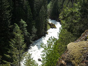 At Nooksack Falls
the river flows through a narrow valley and drops freely 88 feet (26.8 m) into a deep rocky river canyon. The falls are viewable from the forested cover near the cliff edge. A small parking lot nearby contains a kiosk with information about the falls and a hydroelectric project.
Continuing to flow west, the North Fork receives several tributaries including Wells Creek
, which joins the river right at the base of the falls as well as Glacier Creek, and Canyon Creek, before the river turns briefly south. The Middle Fork and South Fork join within a few miles of one another. The Middle Fork joins first, creating the Nooksack River proper. The South Fork joins just east of Deming
in the Nooksack Indian Reservation
.
.
, then northwest and north, reentering Whatcom County and flowing by Acme
.
and Lynden
. Near Everson, the river is at risk of floods breaching the right bank, allowing flow into lower lands to the north, through Sumas River
and into Canada. At Lynden the river turns southwest and then, near Ferndale
, south, to enter the north side of Bellingham Bay
at the Lummi Indian Reservation
, approximately 3 miles (4.8 km) west of Bellingham
.
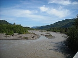
The river is subject to flooding due to high rainfall amounts and some of the deepest snow packs in the country, sometimes triggered by a Pineapple Express
, a weather pattern that brings central Pacific wind and rain to the northwest. One such storm flooded the city of Everson
on November 7, 2006.
near its source and at Nooksack Falls. The river is also partially blocked with a low diversion dam on the Middle Fork by the city of Bellingham to divert water into Lake Whatcom
, Bellingham's drinking water supply.
In the late 19th century, most of the stream flow of the Nooksack River near its mouth flowed through the present channel of the short Lummi River
to Lummi Bay, northwest of Bellingham Bay. Near the turn of the century, a log jam plugged the channel to Lummi Bay, forcing the river to change its channel to the present one. The accumulation of the new river delta has been an ongoing field of research regarding the new wetland
s it has created while no longer resupplying the previous delta on Lummi Bay, except during high flow conditions.
River
A river is a natural watercourse, usually freshwater, flowing towards an ocean, a lake, a sea, or another river. In a few cases, a river simply flows into the ground or dries up completely before reaching another body of water. Small rivers may also be called by several other names, including...
in the northwest part of the U.S. state
U.S. state
A U.S. state is any one of the 50 federated states of the United States of America that share sovereignty with the federal government. Because of this shared sovereignty, an American is a citizen both of the federal entity and of his or her state of domicile. Four states use the official title of...
of Washington. It drains an area of the Cascade Range
Cascade Range
The Cascade Range is a major mountain range of western North America, extending from southern British Columbia through Washington and Oregon to Northern California. It includes both non-volcanic mountains, such as the North Cascades, and the notable volcanoes known as the High Cascades...
around Mount Baker
Mount Baker
Mount Baker , also known as Koma Kulshan or simply Kulshan, is an active glaciated andesitic stratovolcano in the Cascade Volcanic Arc and the North Cascades of Washington State in the United States. It is the second-most active volcano in the range after Mount Saint Helens...
, near the Canadian
Canada
Canada is a North American country consisting of ten provinces and three territories. Located in the northern part of the continent, it extends from the Atlantic Ocean in the east to the Pacific Ocean in the west, and northward into the Arctic Ocean...
border. The lower river flows through a fertile agricultural area before emptying into Bellingham Bay and, via the Strait of Juan de Fuca
Strait of Juan de Fuca
The Strait of Juan de Fuca is a large body of water about long that is the Salish Sea outlet to the Pacific Ocean...
and the Strait of Georgia
Strait of Georgia
The Strait of Georgia or the Georgia Strait is a strait between Vancouver Island and the mainland coast of British Columbia, Canada. It is approximately long and varies in width from...
, the Pacific Ocean
Pacific Ocean
The Pacific Ocean is the largest of the Earth's oceanic divisions. It extends from the Arctic in the north to the Southern Ocean in the south, bounded by Asia and Australia in the west, and the Americas in the east.At 165.2 million square kilometres in area, this largest division of the World...
. The river begins in three main forks, the North Fork, Middle Fork, and South Fork. The North Fork is sometimes considered the main river. Including the North Fork, the Nooksack is approximately 75 miles (120.7 km) long. All three forks originate in the Mount Baker Wilderness
Mount Baker Wilderness
Mount Baker Wilderness in northern Washington, USA,contains . Its eastern border is shared with the boundary of the North Cascades National Park for a distance of 40 miles . The Wilderness extends from State Route 20 north to the Canadian border...
.
North Fork
The North Fork Nooksack River rises at the Nooksack Cirque in central Whatcom CountyWhatcom County, Washington
Whatcom County is a county located in the U.S. state of Washington. Its name ultimately derives from the Lummi word Xwotʼqom, meaning "noisy water." As of 2010, the population was 201,140. The county seat is at Bellingham, which is also the county's largest city...
, north of Mount Shuksan
Mount Shuksan
Mount Shuksan is a glaciated massif in the North Cascades National Park. Shuksan rises in Whatcom County, Washington immediately to the east of Mount Baker, and south of the Canadian border. The mountain's name Shuksan is derived from the Lummi word [šéqsən], said to mean "high peak". The highest...
in the western part of North Cascades National Park
North Cascades National Park
North Cascades National Park is a U.S. National Park located in the state of Washington. The park is the largest of the three National Park Service units that comprise the North Cascades National Park Service Complex. Several national wilderness areas and British Columbia parkland adjoin the...
. It flows generally west, passing north of Mount Baker
Mount Baker
Mount Baker , also known as Koma Kulshan or simply Kulshan, is an active glaciated andesitic stratovolcano in the Cascade Volcanic Arc and the North Cascades of Washington State in the United States. It is the second-most active volcano in the range after Mount Saint Helens...
. For most of its course the North Fork is paralleled by State Route 542 (also called the Mount Baker Highway).
Flowing west from the Nooksack Cirque, the river picks up large creeks such as Price Creek, a short creek draining Price Lake, as well as Ruth Creek, before flowing under the uppermost highway bridge.
Nooksack Falls
Nooksack Falls is a waterfall along the North Fork of the Nooksack River in Whatcom County, Washington. The water flows through a narrow valley and drops freely 88 feet into a deep rocky river canyon. The falls are viewable from the forested cover near the cliffs edge. The falls are a short 2/3...
the river flows through a narrow valley and drops freely 88 feet (26.8 m) into a deep rocky river canyon. The falls are viewable from the forested cover near the cliff edge. A small parking lot nearby contains a kiosk with information about the falls and a hydroelectric project.
Continuing to flow west, the North Fork receives several tributaries including Wells Creek
Wells Creek
Wells Creek is a swift creek in Whatcom County, Washington. It is a tributary of the Nooksack River, joining the river just below Nooksack Falls. It is best known for having six major waterfalls along its course. Wells Creek was named for Hamilton C. Wells who prospected the area in the 1880s...
, which joins the river right at the base of the falls as well as Glacier Creek, and Canyon Creek, before the river turns briefly south. The Middle Fork and South Fork join within a few miles of one another. The Middle Fork joins first, creating the Nooksack River proper. The South Fork joins just east of Deming
Deming, Washington
Deming is a census-designated place in Whatcom County, Washington, United States. Named for its first postmaster, George Deming, its population was 353 at the 2010 census.-Geography:Deming is located at ....
in the Nooksack Indian Reservation
Nooksack (tribe)
The Nooksack are a Native American people in northwestern Washington state in the United States. The tribe lives in the mainland northwest corner of the state near the small town of Deming, Washington , and has over 1,800 enrolled members.In 1971, the tribe was ceded a one acre reservation after...
.
Middle Fork
The Middle Fork Nooksack River, about 20 miles (32.2 km) long, originates on the southern slopes of Mount Baker near Baker Pass. It flows generally northwest between Mount Baker and Twin Sisters MountainTwin Sisters Mountain
Twin Sisters Mountain, commonly called the Twin Sisters, is a mountain in the U.S. state of Washington. Part of the Cascade Range, it lies just southwest of Mount Baker. Of its two main peaks, South Twin is higher, at...
.
South Fork
The South Fork Nooksack River, about 50 miles (80.5 km) long, rises in southern Whatcom County, east of Twin Sisters Mountain near Bell Pass and Lake Wiseman. It flows briefly south, entering Skagit CountySkagit County, Washington
Skagit County is a county in the U.S. state of Washington. It is named after the Skagit Indian tribe. As of 2010, the population was 116,901. It is included in the Mount Vernon-Anacortes, Washington, Metropolitan Statistical Area...
, then northwest and north, reentering Whatcom County and flowing by Acme
Acme, Washington
Acme is a census-designated place in Whatcom County, Washington, United States. The population was 246 at the 2010 census.Acme is located in the South Fork Valley between the northern Cascade Mountains and Lake Whatcom...
.
Nooksack River
After the Middle and South Forks join, the combined river flows northwest, emerging from the mountains and flowing past EversonEverson, Washington
Everson is a city in Whatcom County, Washington, United States. The population was 2,481 at the 2010 census.Everson and the nearby city of Nooksack lie near the foothills of the Cascade mountains in Northwest Washington. Located on the banks of the Nooksack River, the businesses support the...
and Lynden
Lynden, Washington
Lynden is the second largest city in Whatcom County. Named and established in 1874 on the site of the Nooksack Indian village Squahalish , the town of Lynden began as a pioneer settlement headed by Holden and Phoebe Judson and is today home to one of the largest Dutch American communities in the...
. Near Everson, the river is at risk of floods breaching the right bank, allowing flow into lower lands to the north, through Sumas River
Sumas River
The Sumas River is a tributary of the Fraser River in the Canadian province of British Columbia and the U.S. state of Washington.-Course:The Sumas River originates in Whatcom County, Washington just north of the Nooksack River and west of Sumas Mountain...
and into Canada. At Lynden the river turns southwest and then, near Ferndale
Ferndale, Washington
-Demographics:As of the census of 2009, there were 11,681 people, 3,901 households, and 2,303 families residing in the city. The population density was 1,409.1 people per square mile . There were 3,292 housing units at an average density of 529.7 per square mile...
, south, to enter the north side of Bellingham Bay
Bellingham Bay
Bellingham Bay is a bay located on the northern Pacific coast of Washington state in the United States. It is separated from the Strait of Georgia on the west by the Lummi Peninsula, Portage Island, and Lummi Island. It is bordered on the east by Bellingham, Washington, to the south-east by the...
at the Lummi Indian Reservation
Lummi
The Lummi , governed by the Lummi Nation, are a Native American tribe of the Coast Salish ethnolinguistic group in western Washington state in the United States...
, approximately 3 miles (4.8 km) west of Bellingham
Bellingham, Washington
Bellingham is the largest city in, and the county seat of, Whatcom County in the U.S. state of Washington. It is the twelfth-largest city in the state. Situated on Bellingham Bay, Bellingham is protected by Lummi Island, Portage Island, and the Lummi Peninsula, and opens onto the Strait of Georgia...
.
The river is subject to flooding due to high rainfall amounts and some of the deepest snow packs in the country, sometimes triggered by a Pineapple Express
Pineapple Express
Pineapple Express is a non-technical term for a meteorological phenomenon characterized by a strong and persistent flow of atmospheric moisture and associated heavy rainfall from the waters adjacent to the Hawaiian Islands and extending to any location along the Pacific coast of North America...
, a weather pattern that brings central Pacific wind and rain to the northwest. One such storm flooded the city of Everson
Everson, Washington
Everson is a city in Whatcom County, Washington, United States. The population was 2,481 at the 2010 census.Everson and the nearby city of Nooksack lie near the foothills of the Cascade mountains in Northwest Washington. Located on the banks of the Nooksack River, the businesses support the...
on November 7, 2006.
River modifications
The river once supplied hydroelectricityHydroelectricity
Hydroelectricity is the term referring to electricity generated by hydropower; the production of electrical power through the use of the gravitational force of falling or flowing water. It is the most widely used form of renewable energy...
near its source and at Nooksack Falls. The river is also partially blocked with a low diversion dam on the Middle Fork by the city of Bellingham to divert water into Lake Whatcom
Lake Whatcom
Lake Whatcom Reservoir is located in Whatcom County, Washington. It is the drinking water source for approximately 85,000 residents in the City of Bellingham as well as Whatcom County. It is approximately 10 miles total in length and 1 mile in width at its widest...
, Bellingham's drinking water supply.
In the late 19th century, most of the stream flow of the Nooksack River near its mouth flowed through the present channel of the short Lummi River
Lummi River
The Lummi River is the current name for a river channel that was, prior to the beginning of the 20th century, the main outflow channel for the Nooksack River, emptying into Lummi Bay rather than Bellingham Bay, as the current channel of the Nooksack River does...
to Lummi Bay, northwest of Bellingham Bay. Near the turn of the century, a log jam plugged the channel to Lummi Bay, forcing the river to change its channel to the present one. The accumulation of the new river delta has been an ongoing field of research regarding the new wetland
Wetland
A wetland is an area of land whose soil is saturated with water either permanently or seasonally. Wetlands are categorised by their characteristic vegetation, which is adapted to these unique soil conditions....
s it has created while no longer resupplying the previous delta on Lummi Bay, except during high flow conditions.