

Nonnebakken
Encyclopedia
Odense
The city of Odense is the third largest city in Denmark.Odense City has a population of 167,615 and is the main city of the island of Funen...
, Denmark
Denmark
Denmark is a Scandinavian country in Northern Europe. The countries of Denmark and Greenland, as well as the Faroe Islands, constitute the Kingdom of Denmark . It is the southernmost of the Nordic countries, southwest of Sweden and south of Norway, and bordered to the south by Germany. Denmark...
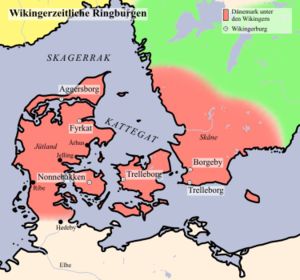
. It is the site of one of Denmark's six former Viking ring castles
Viking ring castles
Trelleborg is a collective name for six Viking Age circular forts, located in Denmark and the southern part of modern Sweden. Five of them have been dated to the reign of the Harold Bluetooth of Denmark...
, built during the reign of Sweyn Forkbeard
Sweyn I of Denmark
Sweyn I Forkbeard was king of Denmark and England, as well as parts of Norway. His name appears as Swegen in the Anglo-Saxon Chronicle and he is also known in English as Svein, Swein, Sven the Dane, and Tuck.He was a Viking leader and the father of Cnut the Great...
, who had forced his father Harold Bluetooth to leave the country and seek refuge by the Jomsvikings
Jomsvikings
The Jomsvikings were a possibly-legendary company of Viking mercenaries or brigands of the 10th century and 14th century AD, dedicated to the worship of such deities as Odin and Thor. They were staunchly pagan, but they reputedly would fight for any lord able to pay their substantial fees, and...
on Wollin (modern Poland) around 975. The fort enabled its occupier command of the Odense River
Odense River
The Odense River is a river located on the island of Funen, in central Denmark. It is about 60 kilometers long and is named after the Funish capital, Odense, which it passes through. Boats can be rented by the river, offering a scenic ride to Fruens Bøge...
passing next to the hill.
The name refers to the Benedictine Nunnery located on the site at earlier times. To the end of the 12th century the Nuns left the site to build a new Church in Dalum to the southeast, now a suburb of Odense.
The earthworks can still be recognized in the panorama of Odense in the "Civitates Orbis Terrarum" from Georg Braun
Georg Braun
Georg Braun was a topo-geographer. From 1572 to 1617 he edited the Civitates orbis terrarum, which contains 546 prospects, bird's-eye views, and maps of cities from all around the world....
and Frans Hogenberg. The engraving is in volume 5, that was finished in 1598 (although first published in 1612-18 in Cologne?), on plate 30, that was made in 1593 from information contributed by Heinrich Rantzau
Heinrich Rantzau
Heinrich Rantzau or Ranzow was a German humanist writer and statesman, a prolific astrologer and an associate of Tycho Brahe. He was son of Johan Rantzau....
or from sketches he gave in order. It also appears on the panorama of Odense published by Braunius in 1593.
The archaeological remains of the fort took heavy damage when a building for the Odd Fellow lodge
Masonic Lodge
This article is about the Masonic term for a membership group. For buildings named Masonic Lodge, see Masonic Lodge A Masonic Lodge, often termed a Private Lodge or Constituent Lodge, is the basic organisation of Freemasonry...
was constructed on the site during the late nineteenth century.
The site was excavated by the Fyns Stiftsmuseum. The castle had a diameter of 120 m and dates to 980-1000, similar to the other Viking ring castles.
Excavation and finds
Although finds have been reported from 1775 and 1889 the extent of the whole structure was first determined in 1953. The next major gain in Information was when in 1988 trenches where dug for laying cables. A ditch with pointed bottom was observed during the excavations. It was at least four meters wide and two meters deep with a berm of maximal 10 to 12 meters. The later filling could be dated to the time of the abbey. The profil of a ditch with pointed bottom eight meters wide and some four meters deep was excavated in the northeast and the northwest. During excavations prior to larger digings for heating pipes in 1995/97/98 a ditch eleven meters wide and three meters deep was observed. A spade made of oak was found that was dated with dendrochronology to the "functioning" time of the structure. Excavations in 2002 revealed parts of the abbey.Literature
External links
- Fund og Fortidsminder (Central register of cultural history) with a list of all activities on the site. .
- History (pdf) of the local Odd Fellows Lodge with information about the place in earlier times.
- The history of Odense page at http://www.museum.odense.dk includes Braunius' 1593 engraving showing the site of Nonnebakken south of the river opposite the medieval city.