
Niger State
Encyclopedia
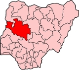
Niger State is a state in the western part of Nigeria
and the largest state
in the country. The state capital is Minna
, and other major cities are Bida, Kontagora
, and Suleja
. It was formed in 1976 when the then North-Western State
was bifurcated
into Niger State and Sokoto State
.
The state is named for the River Niger. Two of Nigeria's major hydroelectric power stations, the Kainji Dam
and the Shiroro Dam, are located in Niger State; also situated there is Kainji National Park, the largest National Park of Nigeria, which contains Kainji Lake
, the Borgu Game Reserve
and the Zugurma Game Reserve
.
on 13 January 2007, the state has adopted sharia law as the code of law, even though the population of the state has been historically evenly divided between Muslims and Christians.
Nigeria
Nigeria , officially the Federal Republic of Nigeria, is a federal constitutional republic comprising 36 states and its Federal Capital Territory, Abuja. The country is located in West Africa and shares land borders with the Republic of Benin in the west, Chad and Cameroon in the east, and Niger in...
and the largest state
States of Nigeria
Nigeria is currently divided into 36 states and Abuja, the federal capital territory. The states are further divided into 774 Local Government Areas....
in the country. The state capital is Minna
Minna
Minna is a city in west central Nigeria. It's the capital of Niger State, one of Nigeria's 36 federal states, and is the headquarters of Chanchaga Local Government Area.- Geography :...
, and other major cities are Bida, Kontagora
Kontagora
Kontagora is a major town on the south bank of the Kontagora River in north-west Niger State, Nigeria. It is the capital city of the Kontagora Emirate....
, and Suleja
Suleja
Suleja is a city in Niger State, Nigeria, pop. local government area, 216,578,just north of Abuja, capital of the Suleja Emirate. It is sometimes confused with the nearby city of Abuja, due to its proximity, and the fact that it was originally called Abuja before the Nigerian government adopted...
. It was formed in 1976 when the then North-Western State
North-Western State
North-Western State is a former administrative division of Nigeria. It was created on 27 May 1967 from parts of the Northern Region and existed until 3 February 1976, when it was divided into two states - Niger and Sokoto. The city of Sokoto was the capital of North-Western State.-North-Western...
was bifurcated
Bifurcation
Bifurcation means the splitting of a main body into two parts.Bifurcation or Bifurcated may refer to:*Bifurcation , the division of issues in a trial for example the division of a page into two parts....
into Niger State and Sokoto State
Sokoto State
Sokoto State is located in the extreme northwest of Nigeria, near to the confluence of the Sokoto River and the Rima River. As of 2005 it has an estimated population of more than 4.2 million...
.
The state is named for the River Niger. Two of Nigeria's major hydroelectric power stations, the Kainji Dam
Kainji Dam
Kainji Dam is a dam across the Niger River in western Nigeria. Construction of the dam began in 1964 and was completed in 1968. The total cost was estimated at $209 million, with one-quarter of this amount used to resettle people displaced by the construction of the dam and its reservoir,...
and the Shiroro Dam, are located in Niger State; also situated there is Kainji National Park, the largest National Park of Nigeria, which contains Kainji Lake
Kainji Lake
Kainji Lake, in western Nigeria, is a reservoir on the Niger River, formed by the Kainji Dam. It was formed in 1968 and is a part of Niger State and Kebbi State. Kainji Lake National Park , situated around the lake, is Nigeria's oldest National Park, established in 1976.-Dam:The Kainji Dam is...
, the Borgu Game Reserve
Borgu Game Reserve
The Borgu Game Reserve is a section of the Kainji National Park, in the Borgu Local Government Area of Niger State and Baruten LocalGovernment Area of Kwara State, Nigeria....
and the Zugurma Game Reserve
Zugurma Game Reserve
The Zugurma Game Reserve is a section of the Kainji National Park, in the Mariga Local Government Area of Niger State, Nigeria.It is bordered by the Kontagora River to the northwest and the Manyara River to the north, and covers an area of 138,500 hectares....
.
Government
Like the majority of Nigerian states, it is governed by a Governor and a House of Assembly. Under the administration of Mu'azu Babangida AliyuMu'azu Babangida Aliyu
Mu’azu Babangida Aliyu is a senior civil servant who was elected governor of Niger State, Nigeria in April 2007.He was reelected on 26 April 2011.-Background:...
on 13 January 2007, the state has adopted sharia law as the code of law, even though the population of the state has been historically evenly divided between Muslims and Christians.
Administrative subdivisions
Niger State is divided into 25 Local Government Areas.- AgaieAgaieAgaie is a Local Government Area in Niger State, Nigeria. Its headquarters are in the town of Agaie on the A124 highway.It has an area of 1,903 km² and a population of 132,907 at the 2006 census.The postal code of the area is 911.-History:...
- AgwaraAgwaraAgwara is a Local Government Area in Niger State, Nigeria. Its headquarters are in the town of Agwara.It has an area of 1,538 km² and a population of 57,413 at the 2006 census.The postal code of the area is 923....
- Bida
- Borgu
- BossoBosso, NigeriaBosso is a Local Government Area in Niger State, Nigeria. Its headquarters are in the town of Maikunkele.It has an area of 1,592 km² and a population of 147,359 at the 2006 census.The postal code of the area is 920....
- ChanchagaChanchagaChanchaga is a Local Government Area in Niger State, Nigeria. Its headquarters are in the state capital of Minna which occupies much of the LGA.It has an area of 72 km² and a population of 201,429 at the 2006 census.The postal code of the area is 920....
- EdatiEdatiEdati is a Local Government Area in Niger State, Nigeria. Its headquarters are in the town of Enagi in the west of the area on the A124 highway at. The LGA consists of two areas, separated by the Kaduna River....
- GbakoGbakoGbako is a Local Government Area in Niger State, Nigeria. Its headquarters are in the town of Lemu in the north of the area at. The Kaduna River forms its western boundary.It has an area of 1,753 km² and a population of 127,466 at the 2006 census....
- GuraraGuraraGurara is a Local Government Area in Niger State, Nigeria, adjoining the Federal Capital Territory. Its headquarters are in the town of Gawu.Major inhabitants are the Gwari people. The Gurara water falls is found here....
- KatchaKatcha, NigeriaKatcha is a Local Government Area in Niger State, Nigeria. Its headquarters are in the town of Badeggi on the A124 highway in the west of the area at.It has an area of 1,681 km² and a population of 122,176 at the 2006 census....
- KontagoraKontagoraKontagora is a major town on the south bank of the Kontagora River in north-west Niger State, Nigeria. It is the capital city of the Kontagora Emirate....
- LapaiLapaiLapai is a Local Government Area in Niger State, Nigeria, adjoining the Federal Capital Territory. Its headquarters are in the town of Lapai on the A124 highway in the west of the area at....
- LavunLavunLavun is a Local Government Area in Niger State, Nigeria. Its headquarters are in the town of Kutigi in the south of the area at. The Kaduna River forms the eastern border of the LGA....
- MagamaMagama, NigeriaMagama redirects here. For the town in Mauritania see MaghamaMagama is a Local Government Area in Niger State, Nigeria. Its headquarters are in the town of Nasko in the west of the area....
- MarigaMariga, NigeriaMariga is a Local Government Area in Niger State, Nigeria. Its headquarters are in the town of Bangi in the north of the area.It has an area of 5,552 km² and a population of 199,430 at the 2006 census.The postal code of the area is 922....
- MasheguMasheguMashegu is a Local Government Area in Niger State, Nigeria. Its headquarters are in the town of Mashegu in the east of the area. Mashegu is bounded by the Niger River in the west and the Kaduna River in the northeast....
- MokwaMokwaMokwa is a Local Government Area in Niger State, Nigeria. Its headquarters are in the town of Mokwa on the A1 highway in the west of the area....
- Munya
- PaikoroPaikoroPaikoro is a Local Government Area in Niger State, Nigeria. Its headquarters are in the town of Paiko about 25 km south of the state capital Minna.It has an area of 2,066 km² and a population of 158,086 at the 2006 census....
- RafiRafi, NigeriaRafi is a Local Government Area in Niger State, Nigeria. Its headquarters are in the town of Kagara on the A125 highway. The southern border of the area is the Kaduna River.It has an area of 3,680 km² and a population of 181,929 at the 2006 census....
- RijauRijauRijau is a Local Government Area in Niger State, Nigeria. Its headquarters are in the town of Rijau.It has an area of 3,196 km² and a population of 176,053 at the 2006 census.The postal code of the area is 923....
- ShiroroShiroroShiroro is a Local Government Area in Niger State, Nigeria. Its headquarters are in the town of Kuta.It has an area of 5,015 km² and a population of 235,404 at the 2006 census.The postal code of the area is 921....
- SulejaSulejaSuleja is a city in Niger State, Nigeria, pop. local government area, 216,578,just north of Abuja, capital of the Suleja Emirate. It is sometimes confused with the nearby city of Abuja, due to its proximity, and the fact that it was originally called Abuja before the Nigerian government adopted...
- TafaTafaTafa is a Local Government Area in Niger State, Nigeria, adjoining the Federal Capital Territory. Its headquarters are in the town of Wuse.It has an area of 222 km² and a population of 83,544 at the 2006 census.The postal code of the area is 910....
- WushishiWushishiWushishi is a Local Government Area in Niger State, Nigeria. Its headquarters are in the town of Wushishi.It has an area of 1,879 km² and a population of 81,783 at the 2006 census.The postal code of the area is 922....