

Newtown, Chester
Encyclopedia
Newtown is an area of Chester
, Cheshire
, England
.
 Newtown is located to the north-east of Chester
, and can be found just outside Chester city walls
and to the east of St Werburgh's Cathederal and the Phoenix Tower
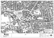
. The main layout of streets came about because of the canal location in the late 1790s and the position of the cattle market, at the centre of the community and on Newtown's doorstep .
The position of Newtown, north-east of the City of Chester, within sight of Saint Werburgh's
Cathederal Chester, and bounded by the Shropshire Union Canal, the Cattle Market and the two Chester Railway stations
, (General and Northgate), meant that Newtown, Boughton
and Hoole
in Chester, were responsible for providing the vast majority of workers and therefore in turn, the vast amount of Chester's wealth production throughout the Industrial Revolution
of the late 18th century.
From about 1793 when the canal at Chester was finished, through to the late 1950s, when the last canalside flour mill closed, Newtown had been increasing in size and importance to the Chester economy. The area supported a thriving community of artisans and working class families who lived mainly in "two-up-two-down" terraced housing with no bathroom and an outside toilet.
Because of the location of the canal and later, due to the great railway building of the 1830s and 1840s in Great Britain, Chester (Newtown), along with Liverpool
and Manchester
became the hub of northern English commerce.
The canal was the 'motorway' of its day and narrowboats carried produce and supplies to and from North Wales (Coal, Slate, Gypsum or Lead Ore). Finished lead (for roofing, water pipes/ and sewerage) produced in the huge Leadworks factory in Edgerton Street Newtown was exported all over the country. Grain arrived from Cheshire farmland and was processed in the large graneries on the banks of the canal at Newtown and Boughton
; and salt, (for preserving food such as fish and meat), came in from Northwich
.
The canal flows into the river Dee, and provided access to the port facilities at Crane Wharf and the sea, and other ports such as the Port of Liverpool
.
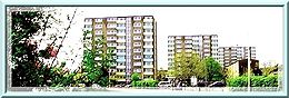 The two large Chester & District Housing Trust run estates, referred to as 'The Saints' Area' and 'Francis Street Flats', are a mixture of sheltered accommodation and normal family occupancy. The 'saints' area has three large 1960s-built tower blocks (St Annes, St Oswalds and St Georges), along with many low-rise houses and maisonettes. On the opposite side of 'Oswald's Way' There are a further 3 tower blocks, namely, Heygarth Heights, Thackery Towers and Rowlands Heights, all built in the 1970's. These properties were built on an area which used to contain the old 'back-to-back' terraced houses; housing workers from the two railway stations, 'The Northgate Station
' and 'The Chester General Station
' and the Royal Mail and the old Chester Cattle Market.
St Oswald's Way virtually dissects the 'old' Newtown in half, and runs almost exactly along the route of what was 'Back Brook Street'. There are still some surviving buildings which used to form part of the bottom end of the street (the top end being the Cattle Market end) - notably, number 24 Back Brook Street. In addition, the backs of the old vegetable and butchers shops can still be seen.
Brook Street, is a local shopping area with a Post Office and shops, pubs and restaurants.
The Newtown area also contains Indian & Chinese restaurants, housing, a small 'arts' cinema and pubs.
Brook Street used to be the main route into Chester from the north. It leads to the railway station, and another area of Newtown, (Francis Street), which has three further 1970's-built 'high-rise' tower blocks and more C&DHT social housing along with private housing.
 Newtown forms part of the City of Chester and West Cheshire in the ceremonial county
of Cheshire
. Chester and West Cheshire came into force in April 2009, when the Local Government and Public Involvement in Health Act was enacted, and replaced the boroughs of Ellesmere Port and Neston
, Vale Royal
and Chester District
. The equivalent unitary authority in the other half of the county is called Cheshire East
. The decision to create the Cheshire West and Chester unitary authority was announced on 25 July 2007 following a consultation period, in which a proposal to create a single Cheshire unitary authority was rejected. Also See:City of Chester (UK Parliament constituency).
Chester
Chester is a city in Cheshire, England. Lying on the River Dee, close to the border with Wales, it is home to 77,040 inhabitants, and is the largest and most populous settlement of the wider unitary authority area of Cheshire West and Chester, which had a population of 328,100 according to the...
, Cheshire
Cheshire
Cheshire is a ceremonial county in North West England. Cheshire's county town is the city of Chester, although its largest town is Warrington. Other major towns include Widnes, Congleton, Crewe, Ellesmere Port, Runcorn, Macclesfield, Winsford, Northwich, and Wilmslow...
, England
England
England is a country that is part of the United Kingdom. It shares land borders with Scotland to the north and Wales to the west; the Irish Sea is to the north west, the Celtic Sea to the south west, with the North Sea to the east and the English Channel to the south separating it from continental...
.
History
Chester
Chester is a city in Cheshire, England. Lying on the River Dee, close to the border with Wales, it is home to 77,040 inhabitants, and is the largest and most populous settlement of the wider unitary authority area of Cheshire West and Chester, which had a population of 328,100 according to the...
, and can be found just outside Chester city walls
Chester city walls
.Chester city walls consist of a defensive structure built to protect the city of Chester in Cheshire, England. Their construction was started by the Romans when they established the fortress of Deva Victrix between 70 and 80 AD. It originated with a rampart of earth and turf surmounted by a...
and to the east of St Werburgh's Cathederal and the Phoenix Tower
Phoenix Tower, Chester
Phoenix Tower stands at the northeast corner of the city walls in Chester, England. The tower has been designated by English Heritage as a Grade I listed building. It has also been known as Newton Tower and King Charles' Tower.-History:...
. The main layout of streets came about because of the canal location in the late 1790s and the position of the cattle market, at the centre of the community and on Newtown's doorstep .
Origins
Newtown is an area of Chester located less than 5 minutes' walk east from the City Walls.The position of Newtown, north-east of the City of Chester, within sight of Saint Werburgh's
Werburgh
Werburh or Wærburh is an English saint and the patron saint of Chester....
Cathederal Chester, and bounded by the Shropshire Union Canal, the Cattle Market and the two Chester Railway stations
Chester railway station
Chester railway station is a railway station in Newtown in the city of Chester, England. It is currently operated by Arriva Trains Wales, although Merseyrail, Northern Rail and Virgin Trains also run services from the station. It is situated to the north-east of the city centre...
, (General and Northgate), meant that Newtown, Boughton
Boughton, Cheshire
Boughton is a neighbourhood to the east of Chester city centre, part of the unitary authority of Cheshire West and Chester and the ceremonial county of Cheshire, England...
and Hoole
Hoole
Hoole is a suburb in the east of Chester, in the unitary authority of Cheshire West and Chester and the ceremonial county of Cheshire, England.-History:The settlement was first mentioned in the Register of the Abbey of Saint Werburgh in 1119...
in Chester, were responsible for providing the vast majority of workers and therefore in turn, the vast amount of Chester's wealth production throughout the Industrial Revolution
Industrial Revolution
The Industrial Revolution was a period from the 18th to the 19th century where major changes in agriculture, manufacturing, mining, transportation, and technology had a profound effect on the social, economic and cultural conditions of the times...
of the late 18th century.
From about 1793 when the canal at Chester was finished, through to the late 1950s, when the last canalside flour mill closed, Newtown had been increasing in size and importance to the Chester economy. The area supported a thriving community of artisans and working class families who lived mainly in "two-up-two-down" terraced housing with no bathroom and an outside toilet.
Because of the location of the canal and later, due to the great railway building of the 1830s and 1840s in Great Britain, Chester (Newtown), along with Liverpool
Liverpool
Liverpool is a city and metropolitan borough of Merseyside, England, along the eastern side of the Mersey Estuary. It was founded as a borough in 1207 and was granted city status in 1880...
and Manchester
Manchester
Manchester is a city and metropolitan borough in Greater Manchester, England. According to the Office for National Statistics, the 2010 mid-year population estimate for Manchester was 498,800. Manchester lies within one of the UK's largest metropolitan areas, the metropolitan county of Greater...
became the hub of northern English commerce.
The canal was the 'motorway' of its day and narrowboats carried produce and supplies to and from North Wales (Coal, Slate, Gypsum or Lead Ore). Finished lead (for roofing, water pipes/ and sewerage) produced in the huge Leadworks factory in Edgerton Street Newtown was exported all over the country. Grain arrived from Cheshire farmland and was processed in the large graneries on the banks of the canal at Newtown and Boughton
Boughton, Cheshire
Boughton is a neighbourhood to the east of Chester city centre, part of the unitary authority of Cheshire West and Chester and the ceremonial county of Cheshire, England...
; and salt, (for preserving food such as fish and meat), came in from Northwich
Northwich
Northwich is a town and civil parish in the unitary authority of Cheshire West and Chester and the ceremonial county of Cheshire, England. It lies in the heart of the Cheshire Plain, at the confluence of the rivers Weaver and Dane...
.
The canal flows into the river Dee, and provided access to the port facilities at Crane Wharf and the sea, and other ports such as the Port of Liverpool
Port of Liverpool
The Port of Liverpool is the name for the enclosed 7.5 mile dock system that runs from Brunswick Dock in Liverpool to Seaforth Dock, Seaforth, on the east side of the River Mersey and the Birkenhead Docks between Birkenhead and Wallasey on the west side of the river...
.
Present day (2010)
Chester Northgate railway station
Chester Northgate is a former railway station in Chester, Cheshire that was a terminus for the Cheshire Lines Committee and Great Central Railway...
' and 'The Chester General Station
Chester railway station
Chester railway station is a railway station in Newtown in the city of Chester, England. It is currently operated by Arriva Trains Wales, although Merseyrail, Northern Rail and Virgin Trains also run services from the station. It is situated to the north-east of the city centre...
' and the Royal Mail and the old Chester Cattle Market.
St Oswald's Way virtually dissects the 'old' Newtown in half, and runs almost exactly along the route of what was 'Back Brook Street'. There are still some surviving buildings which used to form part of the bottom end of the street (the top end being the Cattle Market end) - notably, number 24 Back Brook Street. In addition, the backs of the old vegetable and butchers shops can still be seen.
Brook Street, is a local shopping area with a Post Office and shops, pubs and restaurants.
The Newtown area also contains Indian & Chinese restaurants, housing, a small 'arts' cinema and pubs.
Brook Street used to be the main route into Chester from the north. It leads to the railway station, and another area of Newtown, (Francis Street), which has three further 1970's-built 'high-rise' tower blocks and more C&DHT social housing along with private housing.
Local politics
Ceremonial counties of England
The ceremonial counties are areas of England to which are appointed a Lord Lieutenant, and are defined by the government as counties and areas for the purposes of the Lieutenancies Act 1997 with reference to the metropolitan and non-metropolitan counties of England and Lieutenancies Act 1997...
of Cheshire
Cheshire
Cheshire is a ceremonial county in North West England. Cheshire's county town is the city of Chester, although its largest town is Warrington. Other major towns include Widnes, Congleton, Crewe, Ellesmere Port, Runcorn, Macclesfield, Winsford, Northwich, and Wilmslow...
. Chester and West Cheshire came into force in April 2009, when the Local Government and Public Involvement in Health Act was enacted, and replaced the boroughs of Ellesmere Port and Neston
Ellesmere Port and Neston
Ellesmere Port and Neston was, from 1974 to 2009, a local government district with borough status in Cheshire, England. It covered the southern part of the Wirral Peninsula, namely that part which is not included in the Metropolitan Borough of Wirral....
, Vale Royal
Vale Royal
Vale Royal was, from 1974 to 2009, a local government district with borough status in Cheshire, England. It contained the towns of Northwich, Winsford and Frodsham.-Creation:...
and Chester District
Chester (district)
Chester was a non-metropolitan local government district of Cheshire, England, with the status of a city and a borough.Apart from Chester itself, which was the principal settlement, the district covered a large rural area...
. The equivalent unitary authority in the other half of the county is called Cheshire East
Cheshire East
Cheshire East is a unitary authority area with borough status in the ceremonial county of Cheshire, England.The borough was established in April 2009 as part of the 2009 structural changes to local government in England, by virtue of an order under the Local Government and Public Involvement in...
. The decision to create the Cheshire West and Chester unitary authority was announced on 25 July 2007 following a consultation period, in which a proposal to create a single Cheshire unitary authority was rejected. Also See:City of Chester (UK Parliament constituency).