
Newark Bay
Encyclopedia
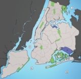
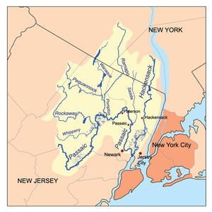
Newark Bay is a tidal bay
at the confluence
of the Passaic
and Hackensack
Rivers in northeastern New Jersey
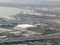
. It is home to the Port Newark-Elizabeth Marine Terminal
, the largest container shipping facility in Port of New York and New Jersey
, 3rd largest and one of busiest in the United States
. An estuary
, it is periodically dredged to accommodate ocean-going container ship
s.
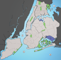
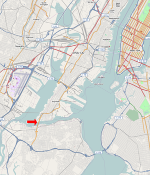
1.2 miles. It is enclosed on the west by the cities of Newark
and Elizabeth
, and on the east by Jersey City
and Bayonne
. At the south is Staten Island, New York and at the north Kearny Point and Droyer's Point
mark the mouth of the Hackensack. Shooters Island
is a bird sanctuary where the borders of Staten Island, Bayonne
and Elizabeth
meet at one point.
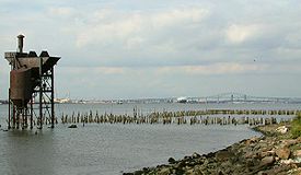
The southern tip of Bergen Neck
, known as Bergen Point, juts into the bay and lent its name to the former Bergen Point Lighthouse. Built offshore in 1849 it was demolished and replaced with a skeletal tower in the mid 20th century.
The Atlantic Ocean
at Sandy Hook
and Rockaway Point is approximately 11 miles away and reached by tidal strait
s dredged to maintain shipping lanes. Newark Bay is connected to Upper New York Bay
by the Kill Van Kull
and to Raritan Bay
by the Arthur Kill
. The names of the channels reflect the period of Dutch colonialization
. The area around the bay was called Achter Kol, which translates as behind or beyond the ridge and refers to Bergen Hill
. The emergence of the Hudson Palisades begins on Bergen Neck
, the peninsula between the bay and the Hudson River. Kill
in Dutch
means stream or channel. During the British colonial era the bay was known as Cull bay.
Kill van Kull literally translates as channel from the ridge. Arthur Kill is an anglicisation
of achter kill meaning back channel, which would speak to its location behind Staten Island.
Many of the maritime and distribution facilities along the bay are part of Foreign Trade Zone 49
which carries the Newark Bay Extension
of the New Jersey Turnpike
. The Lehigh Valley Railroad Bridge
is a vertical lift bridge north of the Casciano is now used by CSX Transportation
for freight shipment, including the notable Juice Train
. Central Railroad of New Jersey
's Newark Bay Bridge crossed the bay from 1864 to connect its Communipaw Terminal
. Last used in 1978, it was determined to be a hazard to maritime navigation and demolished in the 1980s.
is the site of the first English speaking European settlement (1675) in New Jersey
, its port at the southern end of the bay a major maritme hub during the colonial era. Jersey Gardens
, an outlet mall, has been located north of Elizabethport since 1999. There are plans to construct a mixed used community adjacent to it along the bay.
The western edge of Newark Bay was originally shallow tidal wetlands covering approximately 12 square miles (31.1 km²). In 1910s the City of Newark began excavating an angled shipping channel
in the northeastern quadrant of the wetland which formed the basis of Port Newark. Work on the channel and terminal facilities on its north side accelerated during World War I
, when the federal government took control of Port Newark. During the war there were close to 25,000 troops stationed at the Newark Bay Shipyard.
The City decided to expand the port at the end of the war.
The Port Authority of New York and New Jersey
was formed in 1921 and the Newark Bay Channels were authorized by the Rivers and Harbors Act
s in 1922. Shipping operations languished after the war, and in 1927, the City of Newark started construction of Newark Liberty International Airport
on the northwest quadrant of the wetlands which lay between Port Newark and the edge of the developed city. Port Authority took over the operations of Port Newark and the Newark Airport in 1948 and began modernizing and expanding both facilities southward. In 1958, the Port Authority dredged another shipping channel which straightened the course of Bound Brook, the tidal inlet
forming the boundary between Newark and Elizabeth. Dredged materials was used to create new upland south of the new Elizabeth Channel, where the Port Authority constructed the Elizabeth Marine Terminal. The first shipping facility to open upon the Elizabeth Channel was the new 90 acres (36.4 ha) Sea-Land Container Terminal
, which was the prototype for virtually every other container terminal constructed thereafter.
The Ironbound
is an industrial area along the bay which becomes residential farther inland near Downtown Newark
.
Kearny Works and Federal Shipbuilding and Drydock Company
, the shipyards of which operated from 1917 to 1949 and played a prominent role in both World War I
and World War II
.
 While there was some martime development on the eastern banks of the bay closer Bergen Point most of the eastern shore abuts residential and recreational areas. The Hackensack RiverWalk
is a partially completed linear park
greenway
intended to link the string of parks along its banks and that of the Hackensack River
from the Bayonne Bridge
to the Hackensack Meadowlands in Secaucus
and North Bergen
. In Bayonne much of the bay has not seen bulkhead
development, and hence has a natural shore line. The city's largest parks are its shores. At Droyer's Point
recreational and residential development have included a promenade.
is a container
port facility located at the northwestern corner of Staten Island
at the entrance to the Arthur Kill. Nearby is Port Ivory
, named for the Ivory Soap
plant once located there. To the east is the residential neighborhood of Mariners Harbor
which overlooks the bay. In the first half of the 20th century, Bethlehem Steel
maintained a plant which built military transports during World War I and World War II. Currently, tugboat
companies and number of smaller dry docks operate along the shore.
 Both the tributaries, particularly the Passaic River, have sections which are lined with heavy industry. Some industrial facilities discharged wastes into the tributaries during the nineteenth and twentieth centuries, prior to passage to the 1972 Clean Water Act
. High levels of PCBs and dioxin have been detected in the bay. It also has high levels of mercury
, copper
and other toxic chemicals.
While illegal discharges of chemical waste have been stopped, crab
bing is illegal and fishing
is limited due to chemicals that remain in the sediment
.
Bay
A bay is an area of water mostly surrounded by land. Bays generally have calmer waters than the surrounding sea, due to the surrounding land blocking some waves and often reducing winds. Bays also exist as an inlet in a lake or pond. A large bay may be called a gulf, a sea, a sound, or a bight...
at the confluence
Confluence
Confluence, in geography, describes the meeting of two or more bodies of water.Confluence may also refer to:* Confluence , a property of term rewriting systems...
of the Passaic
Passaic River
The Passaic River is a mature surface river, approximately 80 mi long, in northern New Jersey in the United States. The river in its upper course flows in a highly circuitous route, meandering through the swamp lowlands between the ridge hills of rural and suburban northern New Jersey,...
and Hackensack
Hackensack River
The Hackensack River is a river, approximately 45 miles long, in the U.S. states of New York and New Jersey, emptying into Newark Bay, a back chamber of New York Harbor. The watershed of the river includes part of the suburban area outside New York City just west of the lower Hudson River,...
Rivers in northeastern New Jersey
Gateway Region
The Gateway Region is located in the northeastern part of State of New Jersey in the United States of America. The area encompasses Bergen, Essex, Hudson, Passaic, Union and Middlesex counties...
. It is home to the Port Newark-Elizabeth Marine Terminal
Port Newark-Elizabeth Marine Terminal
Port Newark-Elizabeth Marine Terminal is a major component of the Port of New York and New Jersey. Located on the Newark Bay it serves as the principal container ship facility for goods entering and leaving New York-Newark metropolitan area, and the northeastern quadrant of North America...
, the largest container shipping facility in Port of New York and New Jersey
Port of New York and New Jersey
The Port of New York and New Jersey comprises the waterways in the estuary of the New York-Newark metropolitan area with a port district encompassing an approximate area within a radius of the Statue of Liberty National Monument...
, 3rd largest and one of busiest in the United States
United States
The United States of America is a federal constitutional republic comprising fifty states and a federal district...
. An estuary
Estuary
An estuary is a partly enclosed coastal body of water with one or more rivers or streams flowing into it, and with a free connection to the open sea....
, it is periodically dredged to accommodate ocean-going container ship
Container ship
Container ships are cargo ships that carry all of their load in truck-size intermodal containers, in a technique called containerization. They form a common means of commercial intermodal freight transport.-History:...
s.
Geography
Newark Bay is rectangular, approximately 5.5 miles (8.9 km) long, varying in width from 0.6 to1.2 miles. It is enclosed on the west by the cities of Newark
Newark, New Jersey
Newark is the largest city in the American state of New Jersey, and the seat of Essex County. As of the 2010 United States Census, Newark had a population of 277,140, maintaining its status as the largest municipality in New Jersey. It is the 68th largest city in the U.S...
and Elizabeth
Elizabeth, New Jersey
Elizabeth is a city in Union County, New Jersey, United States. As of the 2010 United States Census, the city had a total population of 124,969, retaining its ranking as New Jersey's fourth largest city with an increase of 4,401 residents from its 2000 Census population of 120,568...
, and on the east by Jersey City
Jersey City, New Jersey
Jersey City is the seat of Hudson County, New Jersey, United States.Part of the New York metropolitan area, Jersey City lies between the Hudson River and Upper New York Bay across from Lower Manhattan and the Hackensack River and Newark Bay...
and Bayonne
Bayonne, New Jersey
Bayonne is a city in Hudson County, New Jersey, United States. Located in the Gateway Region, Bayonne is a peninsula that is situated between Newark Bay to the west, the Kill van Kull to the south, and New York Bay to the east...
. At the south is Staten Island, New York and at the north Kearny Point and Droyer's Point
Droyer's Point
Droyer's Point is a section of Jersey City, New Jersey at Newark Bay.-Geography:In the southwestern part of the of the city, Droyer's Point is located on the Newark Bay. Its eastern perimeter is New Jersey Route 440. The point is entered from the highway's intersection with Danforth Avenue...
mark the mouth of the Hackensack. Shooters Island
Shooters Island
Shooters Island is a uninhabited island at the southern end of Newark Bay, along the north shore of Staten Island. The boundary between the states of New York and New Jersey runs through the island, with a small portion on the north end of the island belonging to the cities of Bayonne and...
is a bird sanctuary where the borders of Staten Island, Bayonne
Bayonne, New Jersey
Bayonne is a city in Hudson County, New Jersey, United States. Located in the Gateway Region, Bayonne is a peninsula that is situated between Newark Bay to the west, the Kill van Kull to the south, and New York Bay to the east...
and Elizabeth
Elizabeth, New Jersey
Elizabeth is a city in Union County, New Jersey, United States. As of the 2010 United States Census, the city had a total population of 124,969, retaining its ranking as New Jersey's fourth largest city with an increase of 4,401 residents from its 2000 Census population of 120,568...
meet at one point.
The southern tip of Bergen Neck
Bergen Neck
Bergen Neck is a name for the peninsula between the Upper New York Bay and the Newark Bay in the Hudson County, New Jersey municipalities of Bayonne and Jersey City...
, known as Bergen Point, juts into the bay and lent its name to the former Bergen Point Lighthouse. Built offshore in 1849 it was demolished and replaced with a skeletal tower in the mid 20th century.
The Atlantic Ocean
Atlantic Ocean
The Atlantic Ocean is the second-largest of the world's oceanic divisions. With a total area of about , it covers approximately 20% of the Earth's surface and about 26% of its water surface area...
at Sandy Hook
Sandy Hook
Sandy Hook is a barrier spit along the Atlantic coast of New JerseySandy Hook may also refer to:-Places:United States* Sandy Hook , a village in the town of Newtown, Connecticut* Sandy Hook, Kentucky, a city in Elliott County...
and Rockaway Point is approximately 11 miles away and reached by tidal strait
Strait
A strait or straits is a narrow, typically navigable channel of water that connects two larger, navigable bodies of water. It most commonly refers to a channel of water that lies between two land masses, but it may also refer to a navigable channel through a body of water that is otherwise not...
s dredged to maintain shipping lanes. Newark Bay is connected to Upper New York Bay
Upper New York Bay
Upper New York Bay, or Upper Bay, is the traditional heart of the Port of New York and New Jersey, and often called New York Harbor. It is enclosed by the New York City boroughs of Manhattan, Brooklyn, and Staten Island and the Hudson County, New Jersey municipalities of Jersey City and Bayonne.It...
by the Kill Van Kull
Kill Van Kull
The Kill Van Kull is a tidal strait between Staten Island, New York and Bayonne, New Jersey in the United States. Approximately long and wide, it connects Newark Bay with Upper New York Bay. The Robbins Reef Light marks the eastern end of the Kill, Bergen Point its western end...
and to Raritan Bay
Raritan Bay
Raritan Bay is a bay located at the southern portion of Lower New York Bay between the U.S. states of New York and New Jersey and is part of the New York Bight. The bay is bounded on the northwest by New York's Staten Island, on the west by Perth Amboy, New Jersey, on the south by the Raritan...
by the Arthur Kill
Arthur Kill
The Arthur Kill is a tidal strait separating Staten Island, New York from mainland New Jersey, USA, and a major navigational channel of the Port of New York and New Jersey. Kill is from the Middle Dutch word kille, meaning "riverbed" or "water channel"...
. The names of the channels reflect the period of Dutch colonialization
New Netherland
New Netherland, or Nieuw-Nederland in Dutch, was the 17th-century colonial province of the Republic of the Seven United Netherlands on the East Coast of North America. The claimed territories were the lands from the Delmarva Peninsula to extreme southwestern Cape Cod...
. The area around the bay was called Achter Kol, which translates as behind or beyond the ridge and refers to Bergen Hill
Bergen Hill
Bergen Hill refers to the lower Hudson Palisades in New Jersey, USA, where they emerge on Bergen Neck, which in turn is the peninsula between the Hackensack and Hudson River, and their bays. In Hudson County, it reaches a height of 260 feet.-Rail:...
. The emergence of the Hudson Palisades begins on Bergen Neck
Bergen Neck
Bergen Neck is a name for the peninsula between the Upper New York Bay and the Newark Bay in the Hudson County, New Jersey municipalities of Bayonne and Jersey City...
, the peninsula between the bay and the Hudson River. Kill
Kill (body of water)
As a body of water, a kill is a creek. The word comes from the Middle Dutch kille, meaning "riverbed" or "water channel." The modern Dutch term is kil....
in Dutch
Dutch language
Dutch is a West Germanic language and the native language of the majority of the population of the Netherlands, Belgium, and Suriname, the three member states of the Dutch Language Union. Most speakers live in the European Union, where it is a first language for about 23 million and a second...
means stream or channel. During the British colonial era the bay was known as Cull bay.
Kill van Kull literally translates as channel from the ridge. Arthur Kill is an anglicisation
Anglicisation
Anglicisation, or anglicization , is the process of converting verbal or written elements of any other language into a form that is more comprehensible to an English speaker, or, more generally, of altering something such that it becomes English in form or character.The term most often refers to...
of achter kill meaning back channel, which would speak to its location behind Staten Island.
Many of the maritime and distribution facilities along the bay are part of Foreign Trade Zone 49
Foreign trade zone
A foreign-trade zone in the United States is a geographical area, in United States Ports of Entry Ports of Entry, where commercial merchandise, both domestic and foreign receives the same Customs treatment it would if it were outside the commerce of the United States...
Bridges
The bay is spanned by the Vincent R. Casciano Memorial BridgeNewark Bay Bridge
The Newark Bay Bridge is a steel through arch bridge that is continuous across three spans. It crosses Newark Bay and connects the cities of Newark and Bayonne in New Jersey...
which carries the Newark Bay Extension
Interstate 78 in New Jersey
Interstate 78 is an east–west route stretching from Union Township, Lebanon County, Pennsylvania to New York City. In New Jersey, I-78 is called the Phillipsburg–Newark Expressway and the Newark Bay Extension of the New Jersey Turnpike...
of the New Jersey Turnpike
New Jersey Turnpike
The New Jersey Turnpike is a toll road in New Jersey, maintained by the New Jersey Turnpike Authority. According to the International Bridge, Tunnel and Turnpike Association, the Turnpike is the nation's sixth-busiest toll road and is among one of the most heavily traveled highways in the United...
. The Lehigh Valley Railroad Bridge
Lehigh Valley Railroad Bridge
The Lehigh Valley Railroad Bridge is a vertical lift bridge spanning the Newark Bay in northeastern New Jersey. It is used by CSX Transportation travelling through the North Jersey Shared Assets Area of the United States rail network along the National Docks Secondary line. The bridge is just north...
is a vertical lift bridge north of the Casciano is now used by CSX Transportation
CSX Transportation
CSX Transportation operates a Class I railroad in the United States known as the CSX Railroad. It is the main subsidiary of the CSX Corporation. The company is headquartered in Jacksonville, Florida, and owns approximately 21,000 route miles...
for freight shipment, including the notable Juice Train
Juice Train
"Juice Train" is the popular name for famous unit trains of Tropicana fresh orange juice operated by railroads in the United States....
. Central Railroad of New Jersey
Central Railroad of New Jersey
The Central Railroad of New Jersey , commonly known as the Jersey Central Lines or CNJ, was a Class I railroad with origins in the 1830s, lasting until 1976 when it was absorbed into Conrail with the other bankrupt railroads of the Northeastern United States...
's Newark Bay Bridge crossed the bay from 1864 to connect its Communipaw Terminal
Communipaw Terminal
Central Railroad of New Jersey Terminal, sometimes known as Communipaw Terminal was the Central Railroad of New Jersey's waterfront passenger terminal at the mouth of the Hudson River at the Upper New York Bay in Jersey City, New Jersey.-Designation:...
. Last used in 1978, it was determined to be a hazard to maritime navigation and demolished in the 1980s.
Elizabethport to the Ironbound
ElizabethElizabeth, New Jersey
Elizabeth is a city in Union County, New Jersey, United States. As of the 2010 United States Census, the city had a total population of 124,969, retaining its ranking as New Jersey's fourth largest city with an increase of 4,401 residents from its 2000 Census population of 120,568...
is the site of the first English speaking European settlement (1675) in New Jersey
New Jersey
New Jersey is a state in the Northeastern and Middle Atlantic regions of the United States. , its population was 8,791,894. It is bordered on the north and east by the state of New York, on the southeast and south by the Atlantic Ocean, on the west by Pennsylvania and on the southwest by Delaware...
, its port at the southern end of the bay a major maritme hub during the colonial era. Jersey Gardens
Jersey Gardens
Jersey Gardens is a two-level indoor outlet mall in Elizabeth, New Jersey. The mall opened on October 21, 1999, and is the largest outlet mall in New Jersey, and much closer to New York City than its largest outlet mall competitor, Woodbury Common....
, an outlet mall, has been located north of Elizabethport since 1999. There are plans to construct a mixed used community adjacent to it along the bay.
The western edge of Newark Bay was originally shallow tidal wetlands covering approximately 12 square miles (31.1 km²). In 1910s the City of Newark began excavating an angled shipping channel
Channel (geography)
In physical geography, a channel is the physical confine of a river, slough or ocean strait consisting of a bed and banks.A channel is also the natural or human-made deeper course through a reef, sand bar, bay, or any shallow body of water...
in the northeastern quadrant of the wetland which formed the basis of Port Newark. Work on the channel and terminal facilities on its north side accelerated during World War I
World War I
World War I , which was predominantly called the World War or the Great War from its occurrence until 1939, and the First World War or World War I thereafter, was a major war centred in Europe that began on 28 July 1914 and lasted until 11 November 1918...
, when the federal government took control of Port Newark. During the war there were close to 25,000 troops stationed at the Newark Bay Shipyard.
The City decided to expand the port at the end of the war.
The Port Authority of New York and New Jersey
Port Authority of New York and New Jersey
The Port Authority of New York and New Jersey is a bi-state port district, established in 1921 through an interstate compact, that runs most of the regional transportation infrastructure, including the bridges, tunnels, airports, and seaports, within the Port of New York and New Jersey...
was formed in 1921 and the Newark Bay Channels were authorized by the Rivers and Harbors Act
Rivers and Harbors Act
Rivers and Harbors Act may refer to one of many pieces of legislation and appropriations passed by the United States Congress since the first such legislation in 1824. At that time congress appropriated $75,000 to improve navigation on the Ohio and Mississippi rivers by removing sandbars, snags,...
s in 1922. Shipping operations languished after the war, and in 1927, the City of Newark started construction of Newark Liberty International Airport
Newark Liberty International Airport
Newark Liberty International Airport , first named Newark Metropolitan Airport and later Newark International Airport, is an international airport within the city limits of both Newark and Elizabeth, New Jersey, United States...
on the northwest quadrant of the wetlands which lay between Port Newark and the edge of the developed city. Port Authority took over the operations of Port Newark and the Newark Airport in 1948 and began modernizing and expanding both facilities southward. In 1958, the Port Authority dredged another shipping channel which straightened the course of Bound Brook, the tidal inlet
Inlet
An inlet is a narrow body of water between islands or leading inland from a larger body of water, often leading to an enclosed body of water, such as a sound, bay, lagoon or marsh. In sea coasts an inlet usually refers to the actual connection between a bay and the ocean and is often called an...
forming the boundary between Newark and Elizabeth. Dredged materials was used to create new upland south of the new Elizabeth Channel, where the Port Authority constructed the Elizabeth Marine Terminal. The first shipping facility to open upon the Elizabeth Channel was the new 90 acres (36.4 ha) Sea-Land Container Terminal
Container terminal
A container terminal is a facility where cargo containers are transshipped between different transport vehicles, for onward transportation. The transshipment may be between container ships and land vehicles, for example trains or trucks, in which case the terminal is described as a maritime...
, which was the prototype for virtually every other container terminal constructed thereafter.
The Ironbound
Ironbound
The Ironbound is a large working-class neighborhood in Newark, New Jersey. This close-knit, multi-ethnic community covers approximately four square miles . Historically, the area was called "Dutch Neck," "Down Neck," or simply "the Neck," because of the way the Passaic River curved to form what...
is an industrial area along the bay which becomes residential farther inland near Downtown Newark
Downtown Newark
Downtown Newark is Newark, New Jersey's major central business, retail, and cultural district. It is located at a bend in the Passaic River.Downtown is the site of the original Puritan settlement of Newark. The first settlers, led by Robert Treat, landed not far from the present site of the New...
.
Kearny Point
The Kearny Point peninsula is site of the River Terminal, a massive distribution facility. It comprises the former Western ElectricWestern Electric
Western Electric Company was an American electrical engineering company, the manufacturing arm of AT&T from 1881 to 1995. It was the scene of a number of technological innovations and also some seminal developments in industrial management...
Kearny Works and Federal Shipbuilding and Drydock Company
Federal Shipbuilding and Drydock Company
The Federal Shipbuilding and Drydock Company was a United States shipyard, active from 1917 to 1949. During World War II, it built ships as part of the U.S. Government's Emergency Shipbuilding Program. Operated by a subsidiary of the United States Steel Corporation, the shipyard was located at...
, the shipyards of which operated from 1917 to 1949 and played a prominent role in both World War I
World War I
World War I , which was predominantly called the World War or the Great War from its occurrence until 1939, and the First World War or World War I thereafter, was a major war centred in Europe that began on 28 July 1914 and lasted until 11 November 1918...
and World War II
World War II
World War II, or the Second World War , was a global conflict lasting from 1939 to 1945, involving most of the world's nations—including all of the great powers—eventually forming two opposing military alliances: the Allies and the Axis...
.
Bergen Point to Droyer's Point
Hackensack RiverWalk
Hackensack RiverWalk a is partially constructed greenway along the Newark Bay and Hackensack River on the west side of the Bergen Neck peninsula in Hudson County, New Jersey...
is a partially completed linear park
Linear park
A linear park is a park that is much longer than wide. It is often formed as a part of a rails-to-trails conversion of railroad beds to rail trail recreational use...
greenway
Greenway (landscape)
A greenway is a long, narrow piece of land, often used for recreation and pedestrian and bicycle user traffic, and sometimes for streetcar, light rail or retail uses.- Terminology :...
intended to link the string of parks along its banks and that of the Hackensack River
Hackensack River
The Hackensack River is a river, approximately 45 miles long, in the U.S. states of New York and New Jersey, emptying into Newark Bay, a back chamber of New York Harbor. The watershed of the river includes part of the suburban area outside New York City just west of the lower Hudson River,...
from the Bayonne Bridge
Bayonne Bridge
The Bayonne Bridge is the fourth longest steel arch bridge in the world, and was the longest in the world at the time of its completion. It connects Bayonne, New Jersey with Staten Island, New York, spanning the Kill Van Kull. Despite popular belief, it is not a national landmark.The bridge was...
to the Hackensack Meadowlands in Secaucus
Secaucus, New Jersey
Secaucus is a town in Hudson County, New Jersey. As of the 2010 United States Census, the town population was 16,264. Located within the New Jersey Meadowlands, it is the most suburban of the county's municipalities, though large parts of the town are dedicated to light manufacturing, retail, and...
and North Bergen
North Bergen, New Jersey
North Bergen is a township in Hudson County, New Jersey, United States. As of the United States 2010 Census, the township had a total population of 60,773. Originally founded in 1843, the town was much diminished in territory by a series of secessions. Situated on the Hudson Palisades, it is one...
. In Bayonne much of the bay has not seen bulkhead
Bulkhead (barrier)
A bulkhead is a retaining wall, such as a bulkhead within a ship or a watershed retaining wall. It may also be used in mines, to contain flooding.Certain bulkheads, e.g., at the Hudson River are of historical and architectural value....
development, and hence has a natural shore line. The city's largest parks are its shores. At Droyer's Point
Droyer's Point
Droyer's Point is a section of Jersey City, New Jersey at Newark Bay.-Geography:In the southwestern part of the of the city, Droyer's Point is located on the Newark Bay. Its eastern perimeter is New Jersey Route 440. The point is entered from the highway's intersection with Danforth Avenue...
recreational and residential development have included a promenade.
Howland Hook
The Howland Hook Marine TerminalHowland Hook Marine Terminal
The Howland Hook Marine Terminal is a container port facility in the Port of New York and New Jersey located in northwestern Staten Island in New York City...
is a container
Container ship
Container ships are cargo ships that carry all of their load in truck-size intermodal containers, in a technique called containerization. They form a common means of commercial intermodal freight transport.-History:...
port facility located at the northwestern corner of Staten Island
Staten Island
Staten Island is a borough of New York City, New York, United States, located in the southwest part of the city. Staten Island is separated from New Jersey by the Arthur Kill and the Kill Van Kull, and from the rest of New York by New York Bay...
at the entrance to the Arthur Kill. Nearby is Port Ivory
Port Ivory, Staten Island
Port Ivory is a coastal area situated in the northwestern corner of Staten Island, New York City, New York, United States. It is located on Newark Bay near the entrances the Kill van Kull to the west and Arthur Kill to the east....
, named for the Ivory Soap
Ivory (soap)
The name "Ivory" refers to a series of products created by the Procter & Gamble Company , including varieties of a white and mildly fragranced bar soap, that became famous for its pure content and for floating in water. Over the years, the bar soap has been altered into other varieties...
plant once located there. To the east is the residential neighborhood of Mariners Harbor
Mariners Harbor, Staten Island
Mariners Harbor is a neighborhood located in the northwestern part of New York City, USA's borough of Staten Island. It is bordered by Lake Avenue to the east, Lisk Avenue to the south, Richmond Terrace to the north, and Holland Avenue to the west...
which overlooks the bay. In the first half of the 20th century, Bethlehem Steel
Bethlehem Steel
The Bethlehem Steel Corporation , based in Bethlehem, Pennsylvania, was once the second-largest steel producer in the United States, after Pittsburgh, Pennsylvania-based U.S. Steel. After a decline in the U.S...
maintained a plant which built military transports during World War I and World War II. Currently, tugboat
Tugboat
A tugboat is a boat that maneuvers vessels by pushing or towing them. Tugs move vessels that either should not move themselves, such as ships in a crowded harbor or a narrow canal,or those that cannot move by themselves, such as barges, disabled ships, or oil platforms. Tugboats are powerful for...
companies and number of smaller dry docks operate along the shore.
Pollution and marine life
Clean Water Act
The Clean Water Act is the primary federal law in the United States governing water pollution. Commonly abbreviated as the CWA, the act established the goals of eliminating releases of high amounts of toxic substances into water, eliminating additional water pollution by 1985, and ensuring that...
. High levels of PCBs and dioxin have been detected in the bay. It also has high levels of mercury
Mercury (element)
Mercury is a chemical element with the symbol Hg and atomic number 80. It is also known as quicksilver or hydrargyrum...
, copper
Copper
Copper is a chemical element with the symbol Cu and atomic number 29. It is a ductile metal with very high thermal and electrical conductivity. Pure copper is soft and malleable; an exposed surface has a reddish-orange tarnish...
and other toxic chemicals.
While illegal discharges of chemical waste have been stopped, crab
Crab
True crabs are decapod crustaceans of the infraorder Brachyura, which typically have a very short projecting "tail" , or where the reduced abdomen is entirely hidden under the thorax...
bing is illegal and fishing
Fishing
Fishing is the activity of trying to catch wild fish. Fish are normally caught in the wild. Techniques for catching fish include hand gathering, spearing, netting, angling and trapping....
is limited due to chemicals that remain in the sediment
Sediment
Sediment is naturally occurring material that is broken down by processes of weathering and erosion, and is subsequently transported by the action of fluids such as wind, water, or ice, and/or by the force of gravity acting on the particle itself....
.
See also
- Geography of New York-New Jersey Harbor Estuary
- Marine life of New York-New Jersey Harbor Estuary
- Newark Bay, New Jersey rail accident
- Timeline of Jersey City area railroadsTimeline of Jersey City area railroadsFor the purposes of this article, the Jersey City area goes north to Edgewater , south to Bayonne, and includes Kearny Junction and Harrison but not Newark...
- List of bridges, tunnels, and cuts in Hudson County, New Jersey
External links
- "Fishing for Answers in an Urban Estuary" - Teaching Guide About Newark Bay for Elementary Schools (NJDEP)
- New York-New Jersey Harbor Estuary Program - US EPA
- US EPA: Newark Bay Study 2004
- US Army Corps of Engineers: Newark Bay