
New York State Route 9A
Encyclopedia
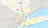
New York State Route 9A (NY 9A) is a state highway
in the vicinity of New York City
, New York
, United States
. Its southern terminus is at the northern end of the Brooklyn–Battery Tunnel in New York City, where it intersects with both Interstate 478 (I-478) and FDR Drive. The northern terminus of NY 9A is at U.S. Route 9 (US 9) in Peekskill
. It is predominantly an alternate route of US 9 between New York City and Peekskill; however, in New York City, it is a major route of its own as it runs along the West Side Highway
and Henry Hudson Parkway
. In Westchester County
, NY 9A follows the Briarcliff–Peekskill Parkway.
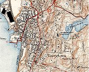
The origins of NY 9A date back to the 1920s when an alternate route of then-NY 6 from Yonkers
to Tarrytown
was designated as New York State Route 6A. NY 6 was redesignated as US 9 in 1927; however, NY 6A was not renumbered to NY 9A until the 1930 renumbering of state highways in New York. NY 9A was extended south into New York City in 1934 and north to Ossining in the late 1930s. In 1933, the Briarcliff–Peekskill Parkway opened as New York State Route 404. All of NY 404 was incorporated into an extended NY 9A in the late 1940s. NY 9A was extended northward to Peekskill in 1967 following the completion of the Croton Expressway
and southward to the Brooklyn–Battery Tunnel between 1985 and 1995.
 Route 9A begins in lower Manhattan
at the north end of the Brooklyn-Battery Tunnel
(I-478) and heads north on the surface West Side Highway
and Henry Hudson Parkway
, crossing US 9 for the first time at the east end of the George Washington Bridge
. After crossing into the Bronx
via the Triborough Bridge and Tunnel Authority
-owned Henry Hudson Bridge
, Route 9A proceeds to leave the parkway at exit 23, joining US 9 on Broadway. The portions of NY 9A between 34th and 72nd Streets in Manhattan and from the Henry Hudson Parkway to the New York City line in the Bronx is maintained by the New York City Department of Transportation
. The concurrency between US 9 and NY 9A runs for 2.87 miles (4.62 km) within the city of Yonkers
. All of NY 9A within Yonkers is maintained by the city.
NY 9A separates from US 9 along Ashburton Avenue and heads north as Saw Mill River Road. It parallels the Saw Mill River Parkway
through Ardsley and Elmsford, to the west side of Hawthorne. The route meets the southbound New York State Thruway
(I-87
) at a partial interchange and later meets I-287
(the Cross Westchester Expressway) at a full interchange that provides a route to the northbound Thruway (I-87). NY 100
merges with NY 9A to form a 3.11 miles (5.01 km) concurrency carrying the names Saw Mill River Road and Briarcliff–Peekskill Parkway, parallel to the Taconic State Parkway
. NY 9A exits off this highway along the Briarcliff–Peekskill Parkway, while NY 100 continues straight as Saw Mill River Road. NY 9A merges to form a brief concurrency with US 9 as the Croton Expressway in Ossining
just south of the Croton River.
The second concurrency between US 9 and NY 9A runs for 0.65 mile (1 km), with Route 9A leaving the Croton Expressway at Croton Point Avenue in Croton-on-Hudson
. The highway heads north along Riverside Avenue and eventually joins old Albany Post Road
. After crossing US 9 once more in Cortlandt, Route 9A ends at the Welcher Avenue interchange
in southern Peekskill.
to Tarrytown
was assigned the NY 6A designation by 1926. This ran along the present alignment of NY 9A from Yonkers to north of Elmsford
, where it turned west on Old Saw Mill River Road, Neperan Road, County House Road and Bedford Road to end at NY 6 in Tarrytown. NY 6 was redesignated as US 9 when U.S. Highways were first posted in New York in 1927; however, NY 6A was not renumbered at this time. It was finally renumbered to NY 9A as part of the 1930 renumbering of state highways in New York.
 New York City
initially did not mark numbered routes within its limits. In 1932, the New York Automobile Club drafted a plan establishing alignments for several routes through the city. In this plan, NY 9A went south through the Bronx
and into Manhattan
on Broadway while US 9 used Riverdale Avenue north of 230th Street. As a result, the two routes would have had a short concurrency
across Spuyten Duyvil Creek
. NY 9A would have split to the south on Tenth Avenue
at 218th Street in order to join the Harlem River Drive
via Nagle Avenue and Dyckman Street. From there it would head west on 155th Street
to Amsterdam Avenue, where it would head south to 79th Street
, heading west there to rejoin US 9 at Riverside Drive. US 9 would have continued south through lower Manhattan
to Staten Island
via the Staten Island Ferry
; however, it is unclear whether NY 9A would have continued south with US 9 to lower Manhattan.
The New York Automobile Club released another plan in 1933. This plan made no changes to NY 9A; however, US 9 was changed to use Broadway all the way through the Bronx and to travel to New Jersey
by way of the Holland Tunnel
. In the final plan implemented in mid-December 1934, no route was assigned to the Harlem River Drive – Amsterdam Avenue corridor. Instead, NY 9A used what had been planned as US 9, splitting at Broadway and Dyckman Street. NY 9A ran south along the west side of Manhattan on Riverside Drive
and the West Side Elevated Highway
(detouring around an unfinished section via 57th Street
, Eleventh Avenue
and 48th Street) to end at the entrance and exit plazas of the Holland Tunnel. US 9 was shifted northward to enter New Jersey via the George Washington Bridge
.
, Saw Mill River Road originally followed the Saw Mill River Parkway
corridor from Eastview to Hawthorne
. Ca. 1931, this section of Saw Mill River Road was designated as part of NY 142, a route that began at NY 100
on the Greenburgh
– Mount Pleasant
town line and followed Grasslands Road, NY 9A, and Saw Mill River Road north to Hawthorne, where it rejoined NY 100. The route went unchanged until it was removed ca. 1938. Its former routing was split into two routes—an extended NY 141
north of NY 9A and the new NY 100C
along Grasslands Road—by 1940. Ca. 1939, NY 9A was extended northward from Tarrytown to Archville, a small hamlet midway between Tarrytown and Ossining, by way of Sleepy Hollow Road.
Farther north, a new highway was built around Ossining
from Saw Mill River Road (NY 100) in Briarcliff Manor
to US 9 north of Ossining. The highway, known as the Briarcliff–Peekskill Parkway, was completed in 1933 and initially designated as NY 404. In the late 1940s, NY 9A was altered to continue north along a slightly realigned Saw Mill River Road from NY 100C near Elmsford
to the south end of the Briarcliff–Peekskill Parkway in Briarcliff Manor. At this point, NY 9A left Saw Mill River Road and followed the parkway to its end at US 9, supplanting NY 404. The realignment created a 3 miles (5 km) overlap between NY 9A and NY 100 from Hawthorne to Briarcliff Manor and resulted in the truncation of NY 141 back to its previous terminus in Hawthorne.
 Construction on the Croton Expressway
, the only piece of the failed Hudson River Expressway project that was ever built, began in the mid-1960s. It became part of a realigned US 9 when it was completed in 1967. The former surface routing of US 9 along Albany Post Road
between Croton-on-Hudson
and Buchanan
became a northward extension of NY 9A, which reached the old alignment by way of an overlap with US 9 from the north end of the Briarcliff–Peekskill Parkway to Croton-on-Hudson.
replaced Riverside Drive
in the mid-1930s, NY 9A was moved onto it, eventually using the new parkway to where it crossed US 9 (Broadway) in the Bronx. Here, NY 9A exited the parkway and ran concurrent with US 9 to the split in Yonkers
. The Brooklyn–Battery Tunnel connecting Manhattan's Battery Park
to Brooklyn
was completed in 1950. By 1960, an extension of the West Side Elevated Highway south to the Manhattan tunnel portal became part of NY 27A
, which had ended in Brooklyn prior to the construction of the tunnel. On January 1, 1970, NY 27A was truncated on its western end to eastern Nassau County
while NY 27
was extended northward over NY 27A's former routing through the Battery Tunnel and the West Side Elevated Highway.
However, by 1973, NY 27 had been cut back to its interchange with the Gowanus Expressway in Brooklyn while I-478 was assigned to both the Battery Tunnel and all of the West Side Elevated Highway south of the Lincoln Tunnel
. NY 9A was cut back to the Lincoln Tunnel as a result. The extension of I-478 into Manhattan was eliminated following the collapse of part of the Elevated Highway in 1973, which led to the demolition of the highway south of 59th Street
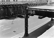
. Demolition was completed in 1989. The surface streets that the Elevated Highway had run atop of—West Street, 11th Avenue and 12th Avenue—became an extension of NY 9A at some point between 1985 and 1995. In early 1996, construction began on a project to convert this section of NY 9A into the West Side Highway
, a six-lane urban boulevard with a parkway-style median and decorative lightposts. The first of the project's seven segments—between Clarkson and Horatio Streets in the Greenwich Village neighborhood—was completed in 1998. The last of the project's pieces was completed in August 2001.
State highway
State highway, state road or state route can refer to one of three related concepts, two of them related to a state or provincial government in a country that is divided into states or provinces :#A...
in the vicinity of New York City
New York City
New York is the most populous city in the United States and the center of the New York Metropolitan Area, one of the most populous metropolitan areas in the world. New York exerts a significant impact upon global commerce, finance, media, art, fashion, research, technology, education, and...
, New York
New York
New York is a state in the Northeastern region of the United States. It is the nation's third most populous state. New York is bordered by New Jersey and Pennsylvania to the south, and by Connecticut, Massachusetts and Vermont to the east...
, United States
United States
The United States of America is a federal constitutional republic comprising fifty states and a federal district...
. Its southern terminus is at the northern end of the Brooklyn–Battery Tunnel in New York City, where it intersects with both Interstate 478 (I-478) and FDR Drive. The northern terminus of NY 9A is at U.S. Route 9 (US 9) in Peekskill
Peekskill, New York
Peekskill is a city in Westchester County, New York. It is situated on a bay along the east side of the Hudson River, across from Jones Point.This community was known to be an early American industrial center, primarily for its iron plow and stove products...
. It is predominantly an alternate route of US 9 between New York City and Peekskill; however, in New York City, it is a major route of its own as it runs along the West Side Highway
West Side Highway
The West Side Highway is a mostly surface section of New York State Route 9A that runs from West 72nd Street along the Hudson River to the southern tip of Manhattan. It replaced the West Side Elevated Highway, built between 1929 and 1951, which was shut down in 1973 due to neglect and lack of...
and Henry Hudson Parkway
Henry Hudson Parkway
The Henry Hudson Parkway is an long parkway in New York City. The southern terminus is at West 72nd Street in Manhattan, where the parkway continues south as the West Side Highway. It is often erroneously referred to as the West Side Highway throughout its entire course in Manhattan...
. In Westchester County
Westchester County, New York
Westchester County is a county located in the U.S. state of New York. Westchester covers an area of and has a population of 949,113 according to the 2010 Census, residing in 45 municipalities...
, NY 9A follows the Briarcliff–Peekskill Parkway.
The origins of NY 9A date back to the 1920s when an alternate route of then-NY 6 from Yonkers
Yonkers, New York
Yonkers is the fourth most populous city in the state of New York , and the most populous city in Westchester County, with a population of 195,976...
to Tarrytown
Tarrytown, New York
Tarrytown is a village in the town of Greenburgh in Westchester County, New York, United States. It is located on the eastern bank of the Hudson River, about north of midtown Manhattan in New York City, and is served by a stop on the Metro-North Hudson Line...
was designated as New York State Route 6A. NY 6 was redesignated as US 9 in 1927; however, NY 6A was not renumbered to NY 9A until the 1930 renumbering of state highways in New York. NY 9A was extended south into New York City in 1934 and north to Ossining in the late 1930s. In 1933, the Briarcliff–Peekskill Parkway opened as New York State Route 404. All of NY 404 was incorporated into an extended NY 9A in the late 1940s. NY 9A was extended northward to Peekskill in 1967 following the completion of the Croton Expressway
Croton Expressway
U.S. Route 9 is a part of the U.S. Highway System that runs from Laurel, Delaware, to Champlain, New York. In New York, US 9 extends from the George Washington Bridge in Manhattan to an interchange with Interstate 87 just south of the Canada – United States border in the town...
and southward to the Brooklyn–Battery Tunnel between 1985 and 1995.
Route description
Lower Manhattan
Lower Manhattan is the southernmost part of the island of Manhattan, the main island and center of business and government of the City of New York...
at the north end of the Brooklyn-Battery Tunnel
Brooklyn-Battery Tunnel
Interstate 478s entire length consists of the Brooklyn–Battery Tunnel and its approaches. Its south end is at Interstate 278, and its north end is at NY 9A ....
(I-478) and heads north on the surface West Side Highway
West Side Highway
The West Side Highway is a mostly surface section of New York State Route 9A that runs from West 72nd Street along the Hudson River to the southern tip of Manhattan. It replaced the West Side Elevated Highway, built between 1929 and 1951, which was shut down in 1973 due to neglect and lack of...
and Henry Hudson Parkway
Henry Hudson Parkway
The Henry Hudson Parkway is an long parkway in New York City. The southern terminus is at West 72nd Street in Manhattan, where the parkway continues south as the West Side Highway. It is often erroneously referred to as the West Side Highway throughout its entire course in Manhattan...
, crossing US 9 for the first time at the east end of the George Washington Bridge
George Washington Bridge
The George Washington Bridge is a suspension bridge spanning the Hudson River, connecting the Washington Heights neighborhood in the borough of Manhattan in New York City to Fort Lee, Bergen County, New Jersey. Interstate 95 and U.S. Route 1/9 cross the river via the bridge. U.S...
. After crossing into the Bronx
The Bronx
The Bronx is the northernmost of the five boroughs of New York City. It is also known as Bronx County, the last of the 62 counties of New York State to be incorporated...
via the Triborough Bridge and Tunnel Authority
Triborough Bridge and Tunnel Authority
MTA Bridges and Tunnels, legal name Triborough Bridge and Tunnel Authority, is a division of the Metropolitan Transportation Authority, that operates seven intrastate toll bridges and two tunnels in New York City...
-owned Henry Hudson Bridge
Henry Hudson Bridge
The Henry Hudson Bridge is a steel arch toll bridge in New York City across the Spuyten Duyvil Creek. It connects the Spuyten Duyvil section of The Bronx with the northern end of Manhattan to the south. On the Manhattan side, it touches Inwood Hill Park. The bridge was designed by David B. Steinman...
, Route 9A proceeds to leave the parkway at exit 23, joining US 9 on Broadway. The portions of NY 9A between 34th and 72nd Streets in Manhattan and from the Henry Hudson Parkway to the New York City line in the Bronx is maintained by the New York City Department of Transportation
New York City Department of Transportation
The New York City Department of Transportation is responsible for the management of much of New York City's transportation infrastructure...
. The concurrency between US 9 and NY 9A runs for 2.87 miles (4.62 km) within the city of Yonkers
Yonkers, New York
Yonkers is the fourth most populous city in the state of New York , and the most populous city in Westchester County, with a population of 195,976...
. All of NY 9A within Yonkers is maintained by the city.
NY 9A separates from US 9 along Ashburton Avenue and heads north as Saw Mill River Road. It parallels the Saw Mill River Parkway
Saw Mill River Parkway
The Saw Mill River Parkway is a north–south parkway that extends for through Westchester County, New York, in the United States. It begins at the border between Westchester County and the Bronx, where it continues into New York City as the Henry Hudson Parkway, and heads generally...
through Ardsley and Elmsford, to the west side of Hawthorne. The route meets the southbound New York State Thruway
New York State Thruway
The New York State Thruway is a system of limited-access highways located within the state of New York in the United States. The system, known officially as the Governor Thomas E. Dewey Thruway for former New York Governor Thomas E. Dewey, is operated by the New York State Thruway Authority and...
(I-87
Interstate 87
Interstate 87 is a Interstate Highway located entirely within New York State in the United States of America. I-87 is the longest intrastate Interstate highway in the Interstate Highway System. Its southern end is at the Bronx approaches of the Robert F. Kennedy Bridge in New York City...
) at a partial interchange and later meets I-287
Interstate 287
Interstate 287 is an auxiliary Interstate Highway in the U.S. states of New Jersey and New York. It is a partial beltway around New York City, serving the northern half of New Jersey and the counties of Rockland and Westchester in New York...
(the Cross Westchester Expressway) at a full interchange that provides a route to the northbound Thruway (I-87). NY 100
New York State Route 100
New York State Route 100 is a major north–south state highway in Westchester County, New York, in the United States. It begins parallel to Interstate 87 at a junction with the Cross County Parkway in the city of Yonkers and runs through most of the length of the county via the city of...
merges with NY 9A to form a 3.11 miles (5.01 km) concurrency carrying the names Saw Mill River Road and Briarcliff–Peekskill Parkway, parallel to the Taconic State Parkway
Taconic State Parkway
The Taconic State Parkway , is a divided highway between Kensico Dam and Chatham, the longest parkway in the U.S. state of New York. It follows a generally northward route midway between the Hudson River and the Connecticut and Massachusetts state lines...
. NY 9A exits off this highway along the Briarcliff–Peekskill Parkway, while NY 100 continues straight as Saw Mill River Road. NY 9A merges to form a brief concurrency with US 9 as the Croton Expressway in Ossining
Ossining (town), New York
Ossining is a town in Westchester County, New York, United States. The population was 37,674 at the 2010 census. It contains two villages, the Village of Ossining and part of Briarcliff Manor, the rest of which is located in the Town of Mount Pleasant....
just south of the Croton River.
The second concurrency between US 9 and NY 9A runs for 0.65 mile (1 km), with Route 9A leaving the Croton Expressway at Croton Point Avenue in Croton-on-Hudson
Croton-on-Hudson, New York
Croton-on-Hudson is a village in Westchester County, New York, United States. The population was 8,070 at the 2010 census. It is located in the town of Cortlandt, in New York City's northern suburbs...
. The highway heads north along Riverside Avenue and eventually joins old Albany Post Road
Albany Post Road
The Albany Post Road was a post road - a road used for mail delivery - in the U.S. state of New York. It connected the cities of New York and Albany along the east side of the Hudson River, a service now performed by US 9.The rough route was as follows:...
. After crossing US 9 once more in Cortlandt, Route 9A ends at the Welcher Avenue interchange
Interchange (road)
In the field of road transport, an interchange is a road junction that typically uses grade separation, and one or more ramps, to permit traffic on at least one highway to pass through the junction without directly crossing any other traffic stream. It differs from a standard intersection, at which...
in southern Peekskill.
Origins
Prior to the establishment of the U.S. Highway System, US 9 was designated as NY 6. An alternate route from YonkersYonkers, New York
Yonkers is the fourth most populous city in the state of New York , and the most populous city in Westchester County, with a population of 195,976...
to Tarrytown
Tarrytown, New York
Tarrytown is a village in the town of Greenburgh in Westchester County, New York, United States. It is located on the eastern bank of the Hudson River, about north of midtown Manhattan in New York City, and is served by a stop on the Metro-North Hudson Line...
was assigned the NY 6A designation by 1926. This ran along the present alignment of NY 9A from Yonkers to north of Elmsford
Elmsford, New York
Elmsford is a village in Westchester County, New York, United States. Roughly one mile square, the village is fully contained within the borders of the town of Greenburgh...
, where it turned west on Old Saw Mill River Road, Neperan Road, County House Road and Bedford Road to end at NY 6 in Tarrytown. NY 6 was redesignated as US 9 when U.S. Highways were first posted in New York in 1927; however, NY 6A was not renumbered at this time. It was finally renumbered to NY 9A as part of the 1930 renumbering of state highways in New York.
New York City
New York is the most populous city in the United States and the center of the New York Metropolitan Area, one of the most populous metropolitan areas in the world. New York exerts a significant impact upon global commerce, finance, media, art, fashion, research, technology, education, and...
initially did not mark numbered routes within its limits. In 1932, the New York Automobile Club drafted a plan establishing alignments for several routes through the city. In this plan, NY 9A went south through the Bronx
The Bronx
The Bronx is the northernmost of the five boroughs of New York City. It is also known as Bronx County, the last of the 62 counties of New York State to be incorporated...
and into Manhattan
Manhattan
Manhattan is the oldest and the most densely populated of the five boroughs of New York City. Located primarily on the island of Manhattan at the mouth of the Hudson River, the boundaries of the borough are identical to those of New York County, an original county of the state of New York...
on Broadway while US 9 used Riverdale Avenue north of 230th Street. As a result, the two routes would have had a short concurrency
Concurrency (road)
A concurrency, overlap, or coincidence in a road network is an instance of one physical road bearing two or more different highway, motorway, or other route numbers...
across Spuyten Duyvil Creek
Spuyten Duyvil Creek
Spuyten Duyvil Creek is a channel connecting the Hudson River to the Harlem River Ship Canal, and on to the Harlem River in New York City, separating the island of Manhattan from the Bronx and the rest of the mainland. The neighborhood named Spuyten Duyvil lies to the north of the creek.Spuyten...
. NY 9A would have split to the south on Tenth Avenue
Tenth Avenue (Manhattan)
Tenth Avenue, known as Amsterdam Avenue north of 59th Street, is a north-south thoroughfare on the West Side of Manhattan in New York City. It carries uptown traffic as far as West 110th Street, also known as Cathedral Parkway for the Cathedral Church of St. John the Divine...
at 218th Street in order to join the Harlem River Drive
Harlem River Drive
The Harlem River Drive is a north–south parkway in the New York City borough of Manhattan. It runs along the west bank of the Harlem River from the Triborough Bridge in East Harlem to 10th Avenue in Inwood, where the parkway continues north as Dyckman Street. The portion of the Harlem River Drive...
via Nagle Avenue and Dyckman Street. From there it would head west on 155th Street
155th Street (Manhattan)
155th Street is a major crosstown street in the Harlem neighborhood, in the New York City borough of Manhattan. It is the northernmost of the 155 crosstown streets mapped out in the Commissioner's Plan of 1811 that established the numbered street grid in Manhattan.155th Street starts on the West...
to Amsterdam Avenue, where it would head south to 79th Street
79th Street (Manhattan)
79th Street is a major two-way street in the Upper East Side and Upper West Side of the New York City borough of Manhattan. East 79th Street stretches from East End Avenue to Fifth Avenue on the Upper East Side, where it enters Central Park through Miners' Gate...
, heading west there to rejoin US 9 at Riverside Drive. US 9 would have continued south through lower Manhattan
Lower Manhattan
Lower Manhattan is the southernmost part of the island of Manhattan, the main island and center of business and government of the City of New York...
to Staten Island
Staten Island
Staten Island is a borough of New York City, New York, United States, located in the southwest part of the city. Staten Island is separated from New Jersey by the Arthur Kill and the Kill Van Kull, and from the rest of New York by New York Bay...
via the Staten Island Ferry
Staten Island Ferry
The Staten Island Ferry is a passenger ferry service operated by the New York City Department of Transportation that runs between the boroughs of Manhattan and Staten Island.-Overview:...
; however, it is unclear whether NY 9A would have continued south with US 9 to lower Manhattan.
The New York Automobile Club released another plan in 1933. This plan made no changes to NY 9A; however, US 9 was changed to use Broadway all the way through the Bronx and to travel to New Jersey
New Jersey
New Jersey is a state in the Northeastern and Middle Atlantic regions of the United States. , its population was 8,791,894. It is bordered on the north and east by the state of New York, on the southeast and south by the Atlantic Ocean, on the west by Pennsylvania and on the southwest by Delaware...
by way of the Holland Tunnel
Holland Tunnel
The Holland Tunnel is a highway tunnel under the Hudson River connecting the island of Manhattan in New York City with Jersey City, New Jersey at Interstate 78 on the mainland. Unusual for an American public works project, it is not named for a government official, politician, or local hero or...
. In the final plan implemented in mid-December 1934, no route was assigned to the Harlem River Drive – Amsterdam Avenue corridor. Instead, NY 9A used what had been planned as US 9, splitting at Broadway and Dyckman Street. NY 9A ran south along the west side of Manhattan on Riverside Drive
Riverside Drive (Manhattan)
Riverside Drive is a scenic north-south thoroughfare in the Manhattan borough of New York City. The boulevard runs on the west side of Manhattan, generally parallel to the Hudson River from 72nd Street to near the George Washington Bridge at 181st Street...
and the West Side Elevated Highway
West Side Elevated Highway
The West Side Elevated Highway was an elevated section of Route NY-9A running along the Hudson River in the New York City borough of Manhattan to the tip of the island.It was an elevated highway, one of the first urban freeways in the world, and served as a...
(detouring around an unfinished section via 57th Street
57th Street (Manhattan)
57th Street is one of New York City's major east-west thoroughfares, which runs east-west in the Midtown section of the borough of Manhattan, from the New York City Department of Sanitation's dock on the Hudson River at the West Side Highway to a small park overlooking the East River built on a...
, Eleventh Avenue
Eleventh Avenue (Manhattan)
Eleventh Avenue is a north-south thoroughfare on the far West Side of the borough of Manhattan in New York City, not far from the Hudson River. It carries downtown traffic only, south of West 44th Street, and two-way traffic north of it....
and 48th Street) to end at the entrance and exit plazas of the Holland Tunnel. US 9 was shifted northward to enter New Jersey via the George Washington Bridge
George Washington Bridge
The George Washington Bridge is a suspension bridge spanning the Hudson River, connecting the Washington Heights neighborhood in the borough of Manhattan in New York City to Fort Lee, Bergen County, New Jersey. Interstate 95 and U.S. Route 1/9 cross the river via the bridge. U.S...
.
Westchester County
In Westchester CountyWestchester County, New York
Westchester County is a county located in the U.S. state of New York. Westchester covers an area of and has a population of 949,113 according to the 2010 Census, residing in 45 municipalities...
, Saw Mill River Road originally followed the Saw Mill River Parkway
Saw Mill River Parkway
The Saw Mill River Parkway is a north–south parkway that extends for through Westchester County, New York, in the United States. It begins at the border between Westchester County and the Bronx, where it continues into New York City as the Henry Hudson Parkway, and heads generally...
corridor from Eastview to Hawthorne
Hawthorne, New York
Hawthorne is an unincorporated hamlet and census-designated place located in the town of Mount Pleasant in Westchester County, New York. The population was 4,586 at the 2010 census.-History:...
. Ca. 1931, this section of Saw Mill River Road was designated as part of NY 142, a route that began at NY 100
New York State Route 100
New York State Route 100 is a major north–south state highway in Westchester County, New York, in the United States. It begins parallel to Interstate 87 at a junction with the Cross County Parkway in the city of Yonkers and runs through most of the length of the county via the city of...
on the Greenburgh
Greenburgh, New York
Greenburgh is a town in the western part of Westchester County, New York, United States. The population was 88,400 at the 2010 census. Paul J. Feiner has been the Town Supervisor since 1991.-History:...
– Mount Pleasant
Mount Pleasant, New York
Mount Pleasant is a town in Westchester County, New York, in the United States. As of the 2010 census, the town population was 43,724.-Geography:...
town line and followed Grasslands Road, NY 9A, and Saw Mill River Road north to Hawthorne, where it rejoined NY 100. The route went unchanged until it was removed ca. 1938. Its former routing was split into two routes—an extended NY 141
New York State Route 141
New York State Route 141 is a north–south state highway in Westchester County, New York, in the United States. It extends for from an interchange with NY 9A in the hamlet of Hawthorne to an intersection with NY 117 in the village of Pleasantville...
north of NY 9A and the new NY 100C
New York State Route 100C
New York State Route 100C is an east–west spur route of NY 100 in Westchester County, New York, in the United States. It extends for along the Greenburgh – Mount Pleasant town line from an intersection with NY 9A to a junction with NY 100 and NY 100A...
along Grasslands Road—by 1940. Ca. 1939, NY 9A was extended northward from Tarrytown to Archville, a small hamlet midway between Tarrytown and Ossining, by way of Sleepy Hollow Road.
Farther north, a new highway was built around Ossining
Ossining (village), New York
Ossining is a village in Westchester County, New York, United States. The population was 25,060 at the 2010 census. As a village, it is located in the Town of Ossining.-Geography:Ossining borders the eastern shores of the widest part of the Hudson River....
from Saw Mill River Road (NY 100) in Briarcliff Manor
Briarcliff Manor, New York
Briarcliff Manor is a village in Westchester County in the state of New York. It is shared between the towns of Mount Pleasant and Ossining, and lies entirely within the ZIP code of 10510...
to US 9 north of Ossining. The highway, known as the Briarcliff–Peekskill Parkway, was completed in 1933 and initially designated as NY 404. In the late 1940s, NY 9A was altered to continue north along a slightly realigned Saw Mill River Road from NY 100C near Elmsford
Elmsford, New York
Elmsford is a village in Westchester County, New York, United States. Roughly one mile square, the village is fully contained within the borders of the town of Greenburgh...
to the south end of the Briarcliff–Peekskill Parkway in Briarcliff Manor. At this point, NY 9A left Saw Mill River Road and followed the parkway to its end at US 9, supplanting NY 404. The realignment created a 3 miles (5 km) overlap between NY 9A and NY 100 from Hawthorne to Briarcliff Manor and resulted in the truncation of NY 141 back to its previous terminus in Hawthorne.
Croton Expressway
U.S. Route 9 is a part of the U.S. Highway System that runs from Laurel, Delaware, to Champlain, New York. In New York, US 9 extends from the George Washington Bridge in Manhattan to an interchange with Interstate 87 just south of the Canada – United States border in the town...
, the only piece of the failed Hudson River Expressway project that was ever built, began in the mid-1960s. It became part of a realigned US 9 when it was completed in 1967. The former surface routing of US 9 along Albany Post Road
Albany Post Road
The Albany Post Road was a post road - a road used for mail delivery - in the U.S. state of New York. It connected the cities of New York and Albany along the east side of the Hudson River, a service now performed by US 9.The rough route was as follows:...
between Croton-on-Hudson
Croton-on-Hudson, New York
Croton-on-Hudson is a village in Westchester County, New York, United States. The population was 8,070 at the 2010 census. It is located in the town of Cortlandt, in New York City's northern suburbs...
and Buchanan
Buchanan, New York
Buchanan is a village located in the town of Cortlandt in Westchester County, New York. The population was 2,230 as of the 2010 census.The Indian Point nuclear power plant is located in Buchanan.-Geography:Buchanan is located at ....
became a northward extension of NY 9A, which reached the old alignment by way of an overlap with US 9 from the north end of the Briarcliff–Peekskill Parkway to Croton-on-Hudson.
New York City
As the Henry Hudson ParkwayHenry Hudson Parkway
The Henry Hudson Parkway is an long parkway in New York City. The southern terminus is at West 72nd Street in Manhattan, where the parkway continues south as the West Side Highway. It is often erroneously referred to as the West Side Highway throughout its entire course in Manhattan...
replaced Riverside Drive
Riverside Drive (Manhattan)
Riverside Drive is a scenic north-south thoroughfare in the Manhattan borough of New York City. The boulevard runs on the west side of Manhattan, generally parallel to the Hudson River from 72nd Street to near the George Washington Bridge at 181st Street...
in the mid-1930s, NY 9A was moved onto it, eventually using the new parkway to where it crossed US 9 (Broadway) in the Bronx. Here, NY 9A exited the parkway and ran concurrent with US 9 to the split in Yonkers
Yonkers, New York
Yonkers is the fourth most populous city in the state of New York , and the most populous city in Westchester County, with a population of 195,976...
. The Brooklyn–Battery Tunnel connecting Manhattan's Battery Park
Battery Park
Battery Park is a 25-acre public park located at the Battery, the southern tip of Manhattan Island in New York City, facing New York Harbor. The Battery is named for artillery batteries that were positioned there in the city's early years in order to protect the settlement behind them...
to Brooklyn
Brooklyn
Brooklyn is the most populous of New York City's five boroughs, with nearly 2.6 million residents, and the second-largest in area. Since 1896, Brooklyn has had the same boundaries as Kings County, which is now the most populous county in New York State and the second-most densely populated...
was completed in 1950. By 1960, an extension of the West Side Elevated Highway south to the Manhattan tunnel portal became part of NY 27A
New York State Route 27A
New York State Route 27A is a state highway extending from Massapequa in Nassau County to Oakdale in Suffolk County on Long Island, New York in the United States...
, which had ended in Brooklyn prior to the construction of the tunnel. On January 1, 1970, NY 27A was truncated on its western end to eastern Nassau County
Nassau County, New York
Nassau County is a suburban county on Long Island, east of New York City in the U.S. state of New York, within the New York Metropolitan Area. As of the 2010 census, the population was 1,339,532...
while NY 27
New York State Route 27
New York State Route 27 is an east–west long state highway extending from Interstate 278 in the New York City borough of Brooklyn to Montauk Point State Park on Long Island, New York, United States...
was extended northward over NY 27A's former routing through the Battery Tunnel and the West Side Elevated Highway.
However, by 1973, NY 27 had been cut back to its interchange with the Gowanus Expressway in Brooklyn while I-478 was assigned to both the Battery Tunnel and all of the West Side Elevated Highway south of the Lincoln Tunnel
Lincoln Tunnel
The Lincoln Tunnel is a long tunnel under the Hudson River, connecting Weehawken, New Jersey and the borough of Manhattan in New York City.-History:...
. NY 9A was cut back to the Lincoln Tunnel as a result. The extension of I-478 into Manhattan was eliminated following the collapse of part of the Elevated Highway in 1973, which led to the demolition of the highway south of 59th Street
59th Street (Manhattan)
59th Street in the New York City borough of Manhattan runs east-west, from York Avenue to the West Side Highway, with a discontinuity between Ninth Avenue/Columbus Avenue and Eighth Avenue/Central Park West for the Time Warner Center. Although it is bi-directional for most of its length, the...
. Demolition was completed in 1989. The surface streets that the Elevated Highway had run atop of—West Street, 11th Avenue and 12th Avenue—became an extension of NY 9A at some point between 1985 and 1995. In early 1996, construction began on a project to convert this section of NY 9A into the West Side Highway
West Side Highway
The West Side Highway is a mostly surface section of New York State Route 9A that runs from West 72nd Street along the Hudson River to the southern tip of Manhattan. It replaced the West Side Elevated Highway, built between 1929 and 1951, which was shut down in 1973 due to neglect and lack of...
, a six-lane urban boulevard with a parkway-style median and decorative lightposts. The first of the project's seven segments—between Clarkson and Horatio Streets in the Greenwich Village neighborhood—was completed in 1998. The last of the project's pieces was completed in August 2001.
Major intersections
See also
- U.S. Route 9 Business (now Route 139Route 139 (New Jersey)Route 139 is a state highway in Jersey City, New Jersey, extending the Pulaski Skyway east to the Holland Tunnel. The western portion of the route is a two level highway that is charted by the New Jersey Department of Transportation as two separate roadways: The lower roadway between U.S...
), which continued Route 9A back to its parent in Jersey City, New JerseyJersey City, New JerseyJersey City is the seat of Hudson County, New Jersey, United States.Part of the New York metropolitan area, Jersey City lies between the Hudson River and Upper New York Bay across from Lower Manhattan and the Hackensack River and Newark Bay...
External links
- Briarcliff-Peekskill Parkway @ NYCROADS.com Includes formerly proposed extension off of NYS Route 9A.
- NY 9A (Greater New York Roads)