
New York State Route 481
Encyclopedia
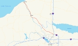
New York State Route 481 (NY 481) is a state highway in Central New York
in the United States
. The southern terminus of the route is at an interchange with Interstate 81
(I-81) in North Syracuse
, where the highway continues southeastward as I-481
. Its northern terminus is located at an intersection with NY 104
in Oswego
about two blocks from Lake Ontario
. In between, NY 481 serves the communities of Clay
, Phoenix
and Fulton
along the Oswego River
. NY 481 is one of two state routes in the Syracuse
area that serves as an extension of an Interstate Highway; the other is NY 690
.
From its southern terminus to the Fulton city line, NY 481 is a four-lane limited-access highway with a handful of interchanges. It enters Fulton as a four-lane undivided highway, but gradually narrows to two lanes as it heads through the northern portion of the city. North of Fulton, NY 481 becomes a four-lane divided highway
and proceeds to the outskirts of Oswego, where it reverts back into a two-lane roadway. NY 481 also serves as a faster alternate to NY 48
from the Syracuse area to downtown Oswego. Both travel along the Oswego River, with NY 481 on the eastern side and NY 48 on the western side.
NY 481 was commissioned in 1970 from North Syracuse to Fulton and extended northward to Oswego in 1982. The portion of the route north of Fulton was designated as NY 20 from 1924 to 1927 and NY 57
from 1927 to 1982. The segment of NY 481 south of Fulton follows a newer facility that was built in the 1970s.
at I-81 (running north to Watertown and south to Syracuse
) and I-481 (continuing east in a loop around Syracuse). This is about a mile to the north of Syracuse Hancock International Airport
. NY 481 begins as an extension of I-481 as it is a four-lane expressway with a handful of interchanges for about the first 20 miles (32 km) of its run. NY 481 crosses U.S. Route 11
(US 11) almost immediately, passing just south of the former site of Penn-Can Mall
. NY 481 then enters the town of Clay
, where it meets NY 31
in the center of a large area of retail shopping, including several strip malls and the Great Northern Mall
.
NY 481 continues northward, mostly through farmland, crossing the Oneida River
and the Erie Canal
at the boundary between Oswego
and Onondaga
counties. Just across the county line, NY 481 has an exit for NY 264
about a mile north of Phoenix
in rural Schroeppel
. The junction with NY 264 is the last interchange on the route. However, NY 481 remains limited-access up to the Fulton city line, where it intersects County Route 57 (CR 57) at-grade. The first 0.28 miles of NY 481 in the city of Fulton starting at the south city line is maintained by the city.
In Fulton, NY 481 travels slowly through the center of town along several predominantly two-lane city streets, and constitutes the main north–south route through that town. Bridges across the Oswego River
may be seen to the west when the road crosses Broadway and Oneida Street. North of the city, NY 481 expands to a four-lane divided highway once more.
The portion of NY 481 from Fulton to Oswego
closely parallels the Oswego River and contains several stretches of scenic beauty, mostly consisting of glimpses of locks
, rapids and small waterfalls through trees along the river. The views are slightly better coming from the north, since the waterfalls are more evident when coming from downstream. Here it closely parallels NY 48, which it is only separated from by the river itself.
NY 481 enters Oswego and becomes the two-lane East River Road, passing by a large post-modern structure which is the Oswego County
Public Safety Center (housing County offices, courts, and a Correctional Facility
). As NY 481 approaches its northern terminus at NY 104
, bridges across the Oswego River can be seen to the west at Bridge Street and Utica Street. East First Street, which NY 481 becomes upon entering downtown and becomes city maintained, continues north past NY 104 to Oswego Harbor on the shores of Lake Ontario
.
beginning at the community of Irving
, where route five
and route twenty merge with Old Lake Shore road, and continuing northeasterly until approximately one mile south of the town of Depew
, Erie county
, then continuing easterly across New York state to its terminus at the New York-Massachusetts border approximately two miles east of the town of New Lebanon
, Columbia county
." This highway never intersects any part of the Veterans Memorial Highway, though it does come within eight miles (13 km) of it at one point. The erroneous sign lies approximately 40 miles (64 km) north of that point.
and NY 690
also travels between Oswego, Fulton and Syracuse, but along the western side of the Oswego River. Although shorter in distance, this route travels through more built-up areas and is significantly slowed by reduced speed limits. This route is therefore more commonly used for trips from Oswego to Baldwinsville
or other points to the west of Syracuse.
to Oswego
via Fulton
on the eastern bank of the Oswego River
was originally designated as Route 34, an unsigned legislative route
, by the New York State Legislature in 1908. When the first set of posted routes in New York
were assigned in 1924, legislative Route 34 was designated as NY 20. NY 20 was redesignated as NY 57
in 1927 to avoid numerical duplication with the newly designated U.S. Route 20. The NY 57 corridor remained unchanged until the late 1950s when construction began on a new roadway to replace the existing two-lane, curvy routing of NY 57 between Fulton and Oswego. It was completed by 1960.
In the mid-1960s, construction began on a limited-access highway linking Fulton to I-81 in North Syracuse
. The under-construction highway, initially known as "Relocated Route 57", was designated as NY 481 on January 1, 1970. The NY 481 designation also extended north to NY 3
in Fulton by way of a short overlap with NY 57. The portion of the expressway between Fulton and NY 31
in Clay
was opened to traffic in the early 1970s while the rest was completed ca. 1973. NY 481 was extended northward to its present terminus in downtown Oswego when the NY 57 designation was eliminated in May 1982.
|-
|rowspan=6|Onondaga
|rowspan=3|North Syracuse
|rowspan=2|0.00
|
|
|Continuation beyond I-81
|-
|9N-S
|
|
|-
|0.50
|10
|
|Access to US 11 via Bear Road and Circle Drive
|-
|rowspan=3|Clay
|
|11
|Caughdenoy Road / Maple Road
|Northbound exit only
|-
|6.97
|12
|
|
|-
|rowspan=2 colspan=4 align="center"|Oneida River
|-
|rowspan=8|Oswego
|rowspan=4|Schroeppel
|-
|10.54
|13
|Phoenix
(CR 57A)
|Northbound exit and southbound entrance
|-
|13.04
|14
|
|
|-
|rowspan=2 colspan=4 align="center"|Begin at-grade intersections northbound and limited-access highway southbound
|-
|rowspan=3|Fulton
|-
|19.49
|
|
|Former routing of NY 57
|-
|20.62
|
|
|
|-
|Oswego
|31.79
|
|
|
Central New York
Central New York is a term used to broadly describe the central region of New York State, roughly including the following counties and cities:...
in the United States
United States
The United States of America is a federal constitutional republic comprising fifty states and a federal district...
. The southern terminus of the route is at an interchange with Interstate 81
Interstate 81 in New York
Interstate 81 is a part of the Interstate Highway System that runs from Dandridge, Tennessee, to the Canada – United States border at Wellesley Island in New York. In the U.S. state of New York, I-81 extends from the Pennsylvania state line southeast of Binghamton to the Canadian border...
(I-81) in North Syracuse
North Syracuse, New York
North Syracuse is a village in Onondaga County, New York, United States. The population was 6,863 at the 2000 census.The Village of North Syracuse is partly in the Town of Cicero, but is primarily within the Town of Clay. North Syracuse is north of the City of Syracuse.- History :The village was...
, where the highway continues southeastward as I-481
Interstate 481
Interstate 481 is an auxiliary Interstate Highway that serves as an eastern bypass of Syracuse, New York, in the United States. It begins at its parent, I-81, in the city's southern end and travels through the eastern Syracuse suburbs of Jamesville, DeWitt, and Cicero before rejoining I-81 in...
. Its northern terminus is located at an intersection with NY 104
New York State Route 104
New York State Route 104 is a long east–west state highway in Upstate New York, United States. It spans six counties and enters the vicinity of four cities—Niagara Falls, Lockport, Rochester, and Oswego—as it follows a routing largely parallel to that of the southern shoreline of Lake...
in Oswego
Oswego, New York
Oswego is a city in Oswego County, New York, United States. The population was 18,142 at the 2010 census. Oswego is located on Lake Ontario in north-central New York and promotes itself as "The Port City of Central New York"...
about two blocks from Lake Ontario
Lake Ontario
Lake Ontario is one of the five Great Lakes of North America. It is bounded on the north and southwest by the Canadian province of Ontario, and on the south by the American state of New York. Ontario, Canada's most populous province, was named for the lake. In the Wyandot language, ontarío means...
. In between, NY 481 serves the communities of Clay
Clay, New York
Clay is a town in Onondaga County, New York, USA. As of the 2000 census, the town had a total population of 58,805, making it Syracuse's largest suburb. The town was named after Henry Clay, statesman....
, Phoenix
Phoenix, New York
Phoenix is a village in Oswego County, New York, United States, about north of Syracuse. The population was 2,251 at the 2000 census. The name is derived from Alexander Phoenix...
and Fulton
Fulton, Oswego County, New York
Fulton is a small city in Oswego County, New York, United States. The population was 11,855 at the 2000 census. The city is named after Robert Fulton, inventor of the steamboat.The city of Fulton is located in the western part of the county....
along the Oswego River
Oswego River (New York)
The Oswego River is a river in upstate New York in the United States. This river is the second-largest river flowing into Lake Ontario. James Fenimore Cooper’s novel The Pathfinder, or The Inland Sea is set in the Oswego River valley...
. NY 481 is one of two state routes in the Syracuse
Syracuse, New York
Syracuse is a city in and the county seat of Onondaga County, New York, United States, the largest U.S. city with the name "Syracuse", and the fifth most populous city in the state. At the 2010 census, the city population was 145,170, and its metropolitan area had a population of 742,603...
area that serves as an extension of an Interstate Highway; the other is NY 690
New York State Route 690
New York State Route 690 is a state highway in Central New York. NY 690's southern terminus is at an interchange with the New York State Thruway and Interstate 690 in Van Buren. The northern terminus is at an intersection with NY 48 and NY 631 in Lysander...
.
From its southern terminus to the Fulton city line, NY 481 is a four-lane limited-access highway with a handful of interchanges. It enters Fulton as a four-lane undivided highway, but gradually narrows to two lanes as it heads through the northern portion of the city. North of Fulton, NY 481 becomes a four-lane divided highway
Divided Highway
Divided Highway is a compilation album by American rock band The Doobie Brothers, released in 2003. . All tracks are taken from the albums Cycles and Brotherhood .-Track listing:...
and proceeds to the outskirts of Oswego, where it reverts back into a two-lane roadway. NY 481 also serves as a faster alternate to NY 48
New York State Route 48
New York State Route 48 is a north–south state highway in Central New York in the United States. The southern terminus of the route is located at Interstate 690 exit 3 near the interchange between I-690 and the New York State Thruway in Van Buren, northwest of Syracuse...
from the Syracuse area to downtown Oswego. Both travel along the Oswego River, with NY 481 on the eastern side and NY 48 on the western side.
NY 481 was commissioned in 1970 from North Syracuse to Fulton and extended northward to Oswego in 1982. The portion of the route north of Fulton was designated as NY 20 from 1924 to 1927 and NY 57
New York State Route 57
New York State Route 57 was a major north–south state highway in Central New York, connecting downtown Syracuse to the Lake Ontario shoreline in Oswego. The southern terminus of the route was at U.S. Route 11 in Syracuse just north of downtown and a short distance east of Lake...
from 1927 to 1982. The segment of NY 481 south of Fulton follows a newer facility that was built in the 1970s.
Route description
NY 481 begins in North SyracuseNorth Syracuse, New York
North Syracuse is a village in Onondaga County, New York, United States. The population was 6,863 at the 2000 census.The Village of North Syracuse is partly in the Town of Cicero, but is primarily within the Town of Clay. North Syracuse is north of the City of Syracuse.- History :The village was...
at I-81 (running north to Watertown and south to Syracuse
Syracuse, New York
Syracuse is a city in and the county seat of Onondaga County, New York, United States, the largest U.S. city with the name "Syracuse", and the fifth most populous city in the state. At the 2010 census, the city population was 145,170, and its metropolitan area had a population of 742,603...
) and I-481 (continuing east in a loop around Syracuse). This is about a mile to the north of Syracuse Hancock International Airport
Syracuse Hancock International Airport
Syracuse Hancock International Airport is a joint civil-military public airport located northeast of Syracuse, in Onondaga County, New York, off of Interstate 81 near Mattydale, New York. The main terminal complex is located at the eastern end of Colonel Eileen Collins Boulevard.-History:In 1927...
. NY 481 begins as an extension of I-481 as it is a four-lane expressway with a handful of interchanges for about the first 20 miles (32 km) of its run. NY 481 crosses U.S. Route 11
U.S. Route 11 in New York
U.S. Route 11 is a part of the U.S. Highway System that runs from New Orleans, Louisiana, to the Canadian border at Rouses Point, New York...
(US 11) almost immediately, passing just south of the former site of Penn-Can Mall
Penn-Can Mall
The Penn-Can Mall is a mall in the town of Cicero, New York, north of Syracuse. It opened on March 28, 1976. It was the first enclosed mall on the north end of Syracuse, and the fourth mall to be built in the entire metropolitan area. It was constructed by the Winmar Company of Seattle, Washington,...
. NY 481 then enters the town of Clay
Clay, New York
Clay is a town in Onondaga County, New York, USA. As of the 2000 census, the town had a total population of 58,805, making it Syracuse's largest suburb. The town was named after Henry Clay, statesman....
, where it meets NY 31
New York State Route 31
New York State Route 31 is a state highway that extends for across western and central New York in the United States. The western terminus of the route is at an intersection with NY 104 in the city of Niagara Falls. Its eastern terminus is at a traffic circle with NY 26 in Vernon...
in the center of a large area of retail shopping, including several strip malls and the Great Northern Mall
Great Northern Mall
The Great Northern Mall is a regional shopping mall located in the Syracuse suburb of Clay, New York.In addition to its 80 stores, a food court, and a 10-screen Regal Cinemas multiplex, the mall is the pre-eminent shopping center for Syracuse's northern suburbs and Oswego County...
.
NY 481 continues northward, mostly through farmland, crossing the Oneida River
Oneida River
The Oneida River in central New York state flows from Oneida Lake to its confluence with the Seneca and Oswego rivers. The Oswego empties the water of the other two rivers into Lake Ontario....
and the Erie Canal
Erie Canal
The Erie Canal is a waterway in New York that runs about from Albany, New York, on the Hudson River to Buffalo, New York, at Lake Erie, completing a navigable water route from the Atlantic Ocean to the Great Lakes. The canal contains 36 locks and encompasses a total elevation differential of...
at the boundary between Oswego
Oswego County, New York
Oswego County is a county located in the U.S. state of New York. As of the 2010 Census, the estimated population was 122,109. The City of Oswego and the Village of Pulaski serve as the dual county seats in a two shire system of government...
and Onondaga
Onondaga County, New York
Onondaga County is a county located in the U.S. state of New York. As of the 2010 census, the population was 467,026. The county seat is Syracuse.Onondaga County is part of the Syracuse, NY Metropolitan Statistical Area....
counties. Just across the county line, NY 481 has an exit for NY 264
New York State Route 264
New York State Route 264 is a north–south state highway in Oswego County, New York, United States. It runs from an intersection with County Route 57 in the village of Phoenix north to a junction with NY 3 in the town of Palermo...
about a mile north of Phoenix
Phoenix, New York
Phoenix is a village in Oswego County, New York, United States, about north of Syracuse. The population was 2,251 at the 2000 census. The name is derived from Alexander Phoenix...
in rural Schroeppel
Schroeppel, New York
Schroeppel is a town in Oswego County, New York, United States. The population was 8,566 at the 2000 census. The name derives from the Schroeppel family, early land owners of the area.The Town of Schroeppel is in the southeast part of the county....
. The junction with NY 264 is the last interchange on the route. However, NY 481 remains limited-access up to the Fulton city line, where it intersects County Route 57 (CR 57) at-grade. The first 0.28 miles of NY 481 in the city of Fulton starting at the south city line is maintained by the city.
In Fulton, NY 481 travels slowly through the center of town along several predominantly two-lane city streets, and constitutes the main north–south route through that town. Bridges across the Oswego River
Oswego River (New York)
The Oswego River is a river in upstate New York in the United States. This river is the second-largest river flowing into Lake Ontario. James Fenimore Cooper’s novel The Pathfinder, or The Inland Sea is set in the Oswego River valley...
may be seen to the west when the road crosses Broadway and Oneida Street. North of the city, NY 481 expands to a four-lane divided highway once more.
The portion of NY 481 from Fulton to Oswego
Oswego, New York
Oswego is a city in Oswego County, New York, United States. The population was 18,142 at the 2010 census. Oswego is located on Lake Ontario in north-central New York and promotes itself as "The Port City of Central New York"...
closely parallels the Oswego River and contains several stretches of scenic beauty, mostly consisting of glimpses of locks
Lock (water transport)
A lock is a device for raising and lowering boats between stretches of water of different levels on river and canal waterways. The distinguishing feature of a lock is a fixed chamber in which the water level can be varied; whereas in a caisson lock, a boat lift, or on a canal inclined plane, it is...
, rapids and small waterfalls through trees along the river. The views are slightly better coming from the north, since the waterfalls are more evident when coming from downstream. Here it closely parallels NY 48, which it is only separated from by the river itself.
NY 481 enters Oswego and becomes the two-lane East River Road, passing by a large post-modern structure which is the Oswego County
Oswego County, New York
Oswego County is a county located in the U.S. state of New York. As of the 2010 Census, the estimated population was 122,109. The City of Oswego and the Village of Pulaski serve as the dual county seats in a two shire system of government...
Public Safety Center (housing County offices, courts, and a Correctional Facility
Prison
A prison is a place in which people are physically confined and, usually, deprived of a range of personal freedoms. Imprisonment or incarceration is a legal penalty that may be imposed by the state for the commission of a crime...
). As NY 481 approaches its northern terminus at NY 104
New York State Route 104
New York State Route 104 is a long east–west state highway in Upstate New York, United States. It spans six counties and enters the vicinity of four cities—Niagara Falls, Lockport, Rochester, and Oswego—as it follows a routing largely parallel to that of the southern shoreline of Lake...
, bridges across the Oswego River can be seen to the west at Bridge Street and Utica Street. East First Street, which NY 481 becomes upon entering downtown and becomes city maintained, continues north past NY 104 to Oswego Harbor on the shores of Lake Ontario
Lake Ontario
Lake Ontario is one of the five Great Lakes of North America. It is bounded on the north and southwest by the Canadian province of Ontario, and on the south by the American state of New York. Ontario, Canada's most populous province, was named for the lake. In the Wyandot language, ontarío means...
.
Official designations
By New York state statute, Route 481, as well as its continuation, Interstate 481, comprise the Veterans Memorial Highway. A sign on the northbound side of Route 481 near its southernmost point announces this. However, a sign on the southbound side of the highway, just after it leaves Fulton, erroneously announces that the highway is the Disabled American Veterans Memorial Highway. The same statute indicates that this is the designation of "that portion of United States route twentyU.S. Route 20
U.S. Route 20 is an east–west United States highway. As the "0" in its route number implies, US 20 is a coast-to-coast route. Spanning , it is the longest road in the United States, and the route sparsely parallels Interstate 90...
beginning at the community of Irving
Irving, New York
Irving is a hamlet located in Chautauqua County, New York, USA. It is located near the east town line and the eastern county line in the Town of Hanover. US Route 20 and New York State Route 5 pass through the hamlet, which is also next to Cattaraugus Creek; New York State Route 438 terminates just...
, where route five
New York State Route 5
New York State Route 5 is a state highway that extends for across the state of New York in the United States. It begins at the Pennsylvania state line in the Chautauqua County town of Ripley and passes through Buffalo, Syracuse, Utica, Schenectady, and several other smaller cities and...
and route twenty merge with Old Lake Shore road, and continuing northeasterly until approximately one mile south of the town of Depew
Depew, New York
Depew is a village in Erie County, New York, United States. The population was 16,629 at the 2000 census. It is part of the Buffalo–Niagara Falls Metropolitan Statistical Area...
, Erie county
Erie County, New York
Erie County is a county located in the U.S. state of New York. As of the 2010 census, the population was 919,040. The county seat is Buffalo. The county's name comes from Lake Erie, which in turn comes from the Erie tribe of American Indians who lived south and east of the lake before 1654.Erie...
, then continuing easterly across New York state to its terminus at the New York-Massachusetts border approximately two miles east of the town of New Lebanon
New Lebanon, New York
New Lebanon is a town in Columbia County, New York, U.S., southeast of Albany. In 1910, 1,378 people lived in New Lebanon, New York. The population was 2,454 at the 2000 census.The town of New Lebanon is in the northeast part of Columbia County...
, Columbia county
Columbia County, New York
Columbia County is a county located in the U.S. state of New York. As of the 2010 census, the population was 63,096. The county seat is Hudson. The name comes from the Latin feminine form of the name of Christopher Columbus, which was at the time of the formation of the county a popular proposal...
." This highway never intersects any part of the Veterans Memorial Highway, though it does come within eight miles (13 km) of it at one point. The erroneous sign lies approximately 40 miles (64 km) north of that point.
Alternate routes
A route combining NY 48New York State Route 48
New York State Route 48 is a north–south state highway in Central New York in the United States. The southern terminus of the route is located at Interstate 690 exit 3 near the interchange between I-690 and the New York State Thruway in Van Buren, northwest of Syracuse...
and NY 690
New York State Route 690
New York State Route 690 is a state highway in Central New York. NY 690's southern terminus is at an interchange with the New York State Thruway and Interstate 690 in Van Buren. The northern terminus is at an intersection with NY 48 and NY 631 in Lysander...
also travels between Oswego, Fulton and Syracuse, but along the western side of the Oswego River. Although shorter in distance, this route travels through more built-up areas and is significantly slowed by reduced speed limits. This route is therefore more commonly used for trips from Oswego to Baldwinsville
Baldwinsville, New York
Baldwinsville is a village in Onondaga County, New York, United States. The population was 7,053 at the 2000 census. It is part of the Syracuse Metropolitan Statistical Area....
or other points to the west of Syracuse.
History
The primary north–south roadway connecting SyracuseSyracuse, New York
Syracuse is a city in and the county seat of Onondaga County, New York, United States, the largest U.S. city with the name "Syracuse", and the fifth most populous city in the state. At the 2010 census, the city population was 145,170, and its metropolitan area had a population of 742,603...
to Oswego
Oswego, New York
Oswego is a city in Oswego County, New York, United States. The population was 18,142 at the 2010 census. Oswego is located on Lake Ontario in north-central New York and promotes itself as "The Port City of Central New York"...
via Fulton
Fulton, Oswego County, New York
Fulton is a small city in Oswego County, New York, United States. The population was 11,855 at the 2000 census. The city is named after Robert Fulton, inventor of the steamboat.The city of Fulton is located in the western part of the county....
on the eastern bank of the Oswego River
Oswego River (New York)
The Oswego River is a river in upstate New York in the United States. This river is the second-largest river flowing into Lake Ontario. James Fenimore Cooper’s novel The Pathfinder, or The Inland Sea is set in the Oswego River valley...
was originally designated as Route 34, an unsigned legislative route
Legislative route
In United States, a legislative route or legislative highway is a highway defined by laws passed in a state legislature. The numbering of such highways may or may not correspond to the numbers familiar to the public as part of the state, U.S. highway, and Interstate highway systems...
, by the New York State Legislature in 1908. When the first set of posted routes in New York
New York
New York is a state in the Northeastern region of the United States. It is the nation's third most populous state. New York is bordered by New Jersey and Pennsylvania to the south, and by Connecticut, Massachusetts and Vermont to the east...
were assigned in 1924, legislative Route 34 was designated as NY 20. NY 20 was redesignated as NY 57
New York State Route 57
New York State Route 57 was a major north–south state highway in Central New York, connecting downtown Syracuse to the Lake Ontario shoreline in Oswego. The southern terminus of the route was at U.S. Route 11 in Syracuse just north of downtown and a short distance east of Lake...
in 1927 to avoid numerical duplication with the newly designated U.S. Route 20. The NY 57 corridor remained unchanged until the late 1950s when construction began on a new roadway to replace the existing two-lane, curvy routing of NY 57 between Fulton and Oswego. It was completed by 1960.
In the mid-1960s, construction began on a limited-access highway linking Fulton to I-81 in North Syracuse
North Syracuse, New York
North Syracuse is a village in Onondaga County, New York, United States. The population was 6,863 at the 2000 census.The Village of North Syracuse is partly in the Town of Cicero, but is primarily within the Town of Clay. North Syracuse is north of the City of Syracuse.- History :The village was...
. The under-construction highway, initially known as "Relocated Route 57", was designated as NY 481 on January 1, 1970. The NY 481 designation also extended north to NY 3
New York State Route 3
New York State Route 3 is a major east–west state highway in New York, United States, that connects central New York to the North Country region near the Canadian border via Adirondack Park. The route extends for between its western terminus at an intersection with NY 104A in the Cayuga...
in Fulton by way of a short overlap with NY 57. The portion of the expressway between Fulton and NY 31
New York State Route 31
New York State Route 31 is a state highway that extends for across western and central New York in the United States. The western terminus of the route is at an intersection with NY 104 in the city of Niagara Falls. Its eastern terminus is at a traffic circle with NY 26 in Vernon...
in Clay
Clay, New York
Clay is a town in Onondaga County, New York, USA. As of the 2000 census, the town had a total population of 58,805, making it Syracuse's largest suburb. The town was named after Henry Clay, statesman....
was opened to traffic in the early 1970s while the rest was completed ca. 1973. NY 481 was extended northward to its present terminus in downtown Oswego when the NY 57 designation was eliminated in May 1982.
Major intersections
The segment of NY 481 between North Syracuse and Fulton is a limited-access highway. Exit numbers continue from I-481.|-
|rowspan=6|Onondaga
Onondaga County, New York
Onondaga County is a county located in the U.S. state of New York. As of the 2010 census, the population was 467,026. The county seat is Syracuse.Onondaga County is part of the Syracuse, NY Metropolitan Statistical Area....
|rowspan=3|North Syracuse
North Syracuse, New York
North Syracuse is a village in Onondaga County, New York, United States. The population was 6,863 at the 2000 census.The Village of North Syracuse is partly in the Town of Cicero, but is primarily within the Town of Clay. North Syracuse is north of the City of Syracuse.- History :The village was...
|rowspan=2|0.00
|
|
|Continuation beyond I-81
|-
|9N-S
|
|
|-
|0.50
|10
|
|Access to US 11 via Bear Road and Circle Drive
|-
|rowspan=3|Clay
Clay, New York
Clay is a town in Onondaga County, New York, USA. As of the 2000 census, the town had a total population of 58,805, making it Syracuse's largest suburb. The town was named after Henry Clay, statesman....
|
|11
|Caughdenoy Road / Maple Road
|Northbound exit only
|-
|6.97
|12
|
|
|-
|rowspan=2 colspan=4 align="center"|Oneida River
Oneida River
The Oneida River in central New York state flows from Oneida Lake to its confluence with the Seneca and Oswego rivers. The Oswego empties the water of the other two rivers into Lake Ontario....
|-
|rowspan=8|Oswego
Oswego County, New York
Oswego County is a county located in the U.S. state of New York. As of the 2010 Census, the estimated population was 122,109. The City of Oswego and the Village of Pulaski serve as the dual county seats in a two shire system of government...
|rowspan=4|Schroeppel
Schroeppel, New York
Schroeppel is a town in Oswego County, New York, United States. The population was 8,566 at the 2000 census. The name derives from the Schroeppel family, early land owners of the area.The Town of Schroeppel is in the southeast part of the county....
|-
|10.54
|13
|Phoenix
Phoenix, New York
Phoenix is a village in Oswego County, New York, United States, about north of Syracuse. The population was 2,251 at the 2000 census. The name is derived from Alexander Phoenix...
(CR 57A)
|Northbound exit and southbound entrance
|-
|13.04
|14
|
|
|-
|rowspan=2 colspan=4 align="center"|Begin at-grade intersections northbound and limited-access highway southbound
|-
|rowspan=3|Fulton
Fulton, Oswego County, New York
Fulton is a small city in Oswego County, New York, United States. The population was 11,855 at the 2000 census. The city is named after Robert Fulton, inventor of the steamboat.The city of Fulton is located in the western part of the county....
|-
|19.49
|
|
|Former routing of NY 57
New York State Route 57
New York State Route 57 was a major north–south state highway in Central New York, connecting downtown Syracuse to the Lake Ontario shoreline in Oswego. The southern terminus of the route was at U.S. Route 11 in Syracuse just north of downtown and a short distance east of Lake...
|-
|20.62
|
|
|
|-
|Oswego
Oswego, New York
Oswego is a city in Oswego County, New York, United States. The population was 18,142 at the 2010 census. Oswego is located on Lake Ontario in north-central New York and promotes itself as "The Port City of Central New York"...
|31.79
|
|
|