

New York State Route 35
Encyclopedia
New York State Route 35 (NY 35) is the principal east–west highway in the northern part of Westchester County, New York
, carrying average daily volumes
of around 16,500 vehicles. Its western terminus is at US 9 in Peekskill
, while its eastern terminus is at the Connecticut
state line in Lewisboro
, where it becomes that state's Route 35.
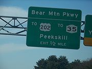 NY 35 begins in the city of Peekskill
at the point where US 6 and US 202 leave US 9 near the upper end of the Croton Expressway
. NY 35 travels east on Main Street (which also begins at that interchange), concurrent with both 6 and 202. US 202 and 35 depart from US 6 and turn onto South Division Street, then Crompond Road. The road within Peekskill is maintained by Westchester County
.
East of Peekskill, NY 35 and US 202 travel along the unfinished section of the Bear Mountain State Parkway
, and, in a way, connect them. The routes meet the Taconic State Parkway
at a newly widened diamond interchange
which immediately precedes the southern terminus of NY 132
in Yorktown
. In the hamlet
of Yorktown Heights
, 35 and 202 turn north onto Saw Mill River Road, picking up NY 118
.
Shortly after Saw Mill River Road crosses into the town of Somers
, Saw Mill River Road becomes Amawalk Road. NY 118 and US 202 depart 35 as they head north onto Tomahawk Street, while 35 heads east. After meeting NY 100
at the Pepsi Cola plant, the road name changes to Woods Bridge Road. In Katonah
the road name changes to Cross River Road. Immediately after, there is an interchange with Interstate 684 and the Saw Mill River Parkway
. Shortly thereafter is an intersection with NY 22
.
In Cross River, 35 forms a short concurrency with NY 121
, then meets with NY 124
and NY 123
in South Salem
. At the New York/Connecticut
state line (Westchester/Fairfield
counties), NY 35 continues into Connecticut as Route 35
, which connects with U.S. Route 7.
and Croton Avenue east of the city was originally designated as part of Route 2, an unsigned legislative route
, by the New York State Legislature in 1908. The route was realigned on March 1, 1921, to enter Peekskill on modern U.S. Route 9 (US 9) instead. In the 1930 renumbering of state highways in New York, various sections of what is now NY 35 were assigned state route designations. From Peekskill to Amawalk, it became part of NY 116
, which continued north from Amawalk on NY 100
(now NY 118
). The portion from Yorktown
to NY 22
in Katonah
via Bedford Road and Jay Street in Katonah was an extension of NY 132
. Lastly, the segment between NY 121
in Cross River and Smith Ridge Road east of South Salem
was designated as part of NY 123
.
In 1934, US 202 was created and routed along NY 116 from Peekskill to Somers
. Farther east, NY 123 was extended westward along current NY 35 to NY 22 northeast of Katonah ca. 1940. In the early 1940s, modern NY 35 in Westchester County
was established, extending across Upper Westchester County on parts of NY 116, NY 132, and NY 123. All three routes were truncated to their current termini at this time. The western terminus of NY 35 was set at US 9 in Peekskill, creating a long overlap with US 202 that still exists today. The number 35 was chosen to match the existing route number in Connecticut. In the 1950s, several plans to build an expressway
along the NY 35 corridor were studied, but none of these plans were built. NY 35 was moved onto its current alignment north of Katonah in the mid-1970s.
Westchester County, New York
Westchester County is a county located in the U.S. state of New York. Westchester covers an area of and has a population of 949,113 according to the 2010 Census, residing in 45 municipalities...
, carrying average daily volumes
Annual average daily traffic
Average Annual daily traffic, abbreviated AADT, is a measure used primarily in transportation planning and transportation engineering. It is the total volume of vehicle traffic of a highway or road for a year divided by 365 days. AADT is a useful and simple measurement of how busy the road is...
of around 16,500 vehicles. Its western terminus is at US 9 in Peekskill
Peekskill, New York
Peekskill is a city in Westchester County, New York. It is situated on a bay along the east side of the Hudson River, across from Jones Point.This community was known to be an early American industrial center, primarily for its iron plow and stove products...
, while its eastern terminus is at the Connecticut
Connecticut
Connecticut is a state in the New England region of the northeastern United States. It is bordered by Rhode Island to the east, Massachusetts to the north, and the state of New York to the west and the south .Connecticut is named for the Connecticut River, the major U.S. river that approximately...
state line in Lewisboro
Lewisboro, New York
Lewisboro is a town in Westchester County, New York, United States. The population was 12,411 at the 2010 census. The town is named after John Lewis.- History :...
, where it becomes that state's Route 35.
Route description
Peekskill, New York
Peekskill is a city in Westchester County, New York. It is situated on a bay along the east side of the Hudson River, across from Jones Point.This community was known to be an early American industrial center, primarily for its iron plow and stove products...
at the point where US 6 and US 202 leave US 9 near the upper end of the Croton Expressway
Croton Expressway
U.S. Route 9 is a part of the U.S. Highway System that runs from Laurel, Delaware, to Champlain, New York. In New York, US 9 extends from the George Washington Bridge in Manhattan to an interchange with Interstate 87 just south of the Canada – United States border in the town...
. NY 35 travels east on Main Street (which also begins at that interchange), concurrent with both 6 and 202. US 202 and 35 depart from US 6 and turn onto South Division Street, then Crompond Road. The road within Peekskill is maintained by Westchester County
Westchester County, New York
Westchester County is a county located in the U.S. state of New York. Westchester covers an area of and has a population of 949,113 according to the 2010 Census, residing in 45 municipalities...
.
East of Peekskill, NY 35 and US 202 travel along the unfinished section of the Bear Mountain State Parkway
Bear Mountain State Parkway
The Bear Mountain State Parkway is a part of the New York State highway system. It was built in 1932 but, unlike most other parkways in Westchester County, New York, it has barely been constructed upon since. It currently stands as an incomplete highway, with a western portion of and an eastern...
, and, in a way, connect them. The routes meet the Taconic State Parkway
Taconic State Parkway
The Taconic State Parkway , is a divided highway between Kensico Dam and Chatham, the longest parkway in the U.S. state of New York. It follows a generally northward route midway between the Hudson River and the Connecticut and Massachusetts state lines...
at a newly widened diamond interchange
Diamond interchange
A diamond interchange is a common type of road junction, used where a freeway crosses a minor road. The freeway itself is grade-separated from the minor road, one crossing the other over a bridge...
which immediately precedes the southern terminus of NY 132
New York State Route 132
New York State Route 132 is a long state highway located entirely within the Town of Yorktown in Westchester County, New York. The route acts as a connector between U.S. Route 202 and NY 35 in the south and U.S. Route 6 in the north...
in Yorktown
Yorktown, New York
Yorktown is a town in Westchester County, New York, in the suburbs of New York about north of midtown Manhattan. The town lies on the north border of Westchester County...
. In the hamlet
Hamlet (place)
A hamlet is usually a rural settlement which is too small to be considered a village, though sometimes the word is used for a different sort of community. Historically, when a hamlet became large enough to justify building a church, it was then classified as a village...
of Yorktown Heights
Yorktown Heights, New York
Yorktown Heights is a census-designated place in the town of Yorktown in Westchester County, New York, United States. The population was 1,781 at the 2010 census.-Geography:Yorktown Heights is located at ....
, 35 and 202 turn north onto Saw Mill River Road, picking up NY 118
New York State Route 118
New York State Route 118 is a north–south state highway that extends for in Downstate New York in the United States. Much of the highway is located within Westchester County; however, a small portion of the route near the northern terminus is situated in Putnam County...
.
Shortly after Saw Mill River Road crosses into the town of Somers
Somers, New York
Somers is a town located in northeastern Westchester County, New York, United States. As of the 2010 census, the town had a population of 20,434...
, Saw Mill River Road becomes Amawalk Road. NY 118 and US 202 depart 35 as they head north onto Tomahawk Street, while 35 heads east. After meeting NY 100
New York State Route 100
New York State Route 100 is a major north–south state highway in Westchester County, New York, in the United States. It begins parallel to Interstate 87 at a junction with the Cross County Parkway in the city of Yonkers and runs through most of the length of the county via the city of...
at the Pepsi Cola plant, the road name changes to Woods Bridge Road. In Katonah
Katonah, New York
Katonah, New York is one of three unincorporated hamlets within the town of Bedford, Westchester County, New York, United States.-History:Katonah is named for Chief Katonah, an American Indian from whom the land of Bedford was purchased by a group of English colonists...
the road name changes to Cross River Road. Immediately after, there is an interchange with Interstate 684 and the Saw Mill River Parkway
Saw Mill River Parkway
The Saw Mill River Parkway is a north–south parkway that extends for through Westchester County, New York, in the United States. It begins at the border between Westchester County and the Bronx, where it continues into New York City as the Henry Hudson Parkway, and heads generally...
. Shortly thereafter is an intersection with NY 22
New York State Route 22
New York State Route 22 is a north–south state highway in eastern New York in the United States. It runs parallel to the state's eastern edge from the outskirts of New York City to a short distance south of the Canadian border. At , it is the state's longest north–south route and...
.
In Cross River, 35 forms a short concurrency with NY 121
New York State Route 121
New York State Route 121 is a north–south state highway in New York, going from northern Westchester County to the village of Brewster in Putnam County.-Route description:...
, then meets with NY 124
New York State Route 124
New York State Route 124 is a long north–south state highway in the northern part of Westchester County, New York, in the United States. The route connects NY 137 in the hamlet of Pound Ridge to NY 35 near the hamlet of South Salem.-Route description:NY 124 begins at...
and NY 123
New York State Route 123
New York State Route 123 is a north–south state highway in the northern part of Westchester County, New York, in the United States...
in South Salem
South Salem, New York
South Salem is a hamlet in Lewisboro, Westchester County, New York. The county ranks second for wealthiest counties in New York State and the seventh wealthiest county nationally. In the town center is a post office, the town hall, a library and a recycling center.Notable residents have included...
. At the New York/Connecticut
Connecticut
Connecticut is a state in the New England region of the northeastern United States. It is bordered by Rhode Island to the east, Massachusetts to the north, and the state of New York to the west and the south .Connecticut is named for the Connecticut River, the major U.S. river that approximately...
state line (Westchester/Fairfield
Fairfield County, Connecticut
Fairfield County is a county located in the southwestern corner of the U.S. state of Connecticut. The county population is 916,829 according to the 2010 Census. There are currently 1,465 people per square mile in the county. It is the most populous county in the State of Connecticut and contains...
counties), NY 35 continues into Connecticut as Route 35
Route 35 (Connecticut)
Route 35 is a state highway in Connecticut, located entirely within the town of Ridgefield. Route 35 starts at the New York state line, where the road continues as New York State Route 35, and ends at U.S. Route 7. The road is often used as an alternative to the congested Route 7...
, which connects with U.S. Route 7.
History
The portion of modern NY 35 between PeekskillPeekskill, New York
Peekskill is a city in Westchester County, New York. It is situated on a bay along the east side of the Hudson River, across from Jones Point.This community was known to be an early American industrial center, primarily for its iron plow and stove products...
and Croton Avenue east of the city was originally designated as part of Route 2, an unsigned legislative route
Legislative route
In United States, a legislative route or legislative highway is a highway defined by laws passed in a state legislature. The numbering of such highways may or may not correspond to the numbers familiar to the public as part of the state, U.S. highway, and Interstate highway systems...
, by the New York State Legislature in 1908. The route was realigned on March 1, 1921, to enter Peekskill on modern U.S. Route 9 (US 9) instead. In the 1930 renumbering of state highways in New York, various sections of what is now NY 35 were assigned state route designations. From Peekskill to Amawalk, it became part of NY 116
New York State Route 116
New York State Route 116 is an east–west state highway in Westchester County, New York, in the United States. It extends for from an intersection with U.S. Route 202 in the hamlet of Somers to the Connecticut state line, where it becomes that state's Route 116...
, which continued north from Amawalk on NY 100
New York State Route 100
New York State Route 100 is a major north–south state highway in Westchester County, New York, in the United States. It begins parallel to Interstate 87 at a junction with the Cross County Parkway in the city of Yonkers and runs through most of the length of the county via the city of...
(now NY 118
New York State Route 118
New York State Route 118 is a north–south state highway that extends for in Downstate New York in the United States. Much of the highway is located within Westchester County; however, a small portion of the route near the northern terminus is situated in Putnam County...
). The portion from Yorktown
Yorktown, New York
Yorktown is a town in Westchester County, New York, in the suburbs of New York about north of midtown Manhattan. The town lies on the north border of Westchester County...
to NY 22
New York State Route 22
New York State Route 22 is a north–south state highway in eastern New York in the United States. It runs parallel to the state's eastern edge from the outskirts of New York City to a short distance south of the Canadian border. At , it is the state's longest north–south route and...
in Katonah
Katonah, New York
Katonah, New York is one of three unincorporated hamlets within the town of Bedford, Westchester County, New York, United States.-History:Katonah is named for Chief Katonah, an American Indian from whom the land of Bedford was purchased by a group of English colonists...
via Bedford Road and Jay Street in Katonah was an extension of NY 132
New York State Route 132
New York State Route 132 is a long state highway located entirely within the Town of Yorktown in Westchester County, New York. The route acts as a connector between U.S. Route 202 and NY 35 in the south and U.S. Route 6 in the north...
. Lastly, the segment between NY 121
New York State Route 121
New York State Route 121 is a north–south state highway in New York, going from northern Westchester County to the village of Brewster in Putnam County.-Route description:...
in Cross River and Smith Ridge Road east of South Salem
South Salem, New York
South Salem is a hamlet in Lewisboro, Westchester County, New York. The county ranks second for wealthiest counties in New York State and the seventh wealthiest county nationally. In the town center is a post office, the town hall, a library and a recycling center.Notable residents have included...
was designated as part of NY 123
New York State Route 123
New York State Route 123 is a north–south state highway in the northern part of Westchester County, New York, in the United States...
.
In 1934, US 202 was created and routed along NY 116 from Peekskill to Somers
Somers, New York
Somers is a town located in northeastern Westchester County, New York, United States. As of the 2010 census, the town had a population of 20,434...
. Farther east, NY 123 was extended westward along current NY 35 to NY 22 northeast of Katonah ca. 1940. In the early 1940s, modern NY 35 in Westchester County
Westchester County, New York
Westchester County is a county located in the U.S. state of New York. Westchester covers an area of and has a population of 949,113 according to the 2010 Census, residing in 45 municipalities...
was established, extending across Upper Westchester County on parts of NY 116, NY 132, and NY 123. All three routes were truncated to their current termini at this time. The western terminus of NY 35 was set at US 9 in Peekskill, creating a long overlap with US 202 that still exists today. The number 35 was chosen to match the existing route number in Connecticut. In the 1950s, several plans to build an expressway
Limited-access road
A limited-access road known by various terms worldwide, including limited-access highway, dual-carriageway and expressway, is a highway or arterial road for high-speed traffic which has many or most characteristics of a controlled-access highway , including limited or no access to adjacent...
along the NY 35 corridor were studied, but none of these plans were built. NY 35 was moved onto its current alignment north of Katonah in the mid-1970s.